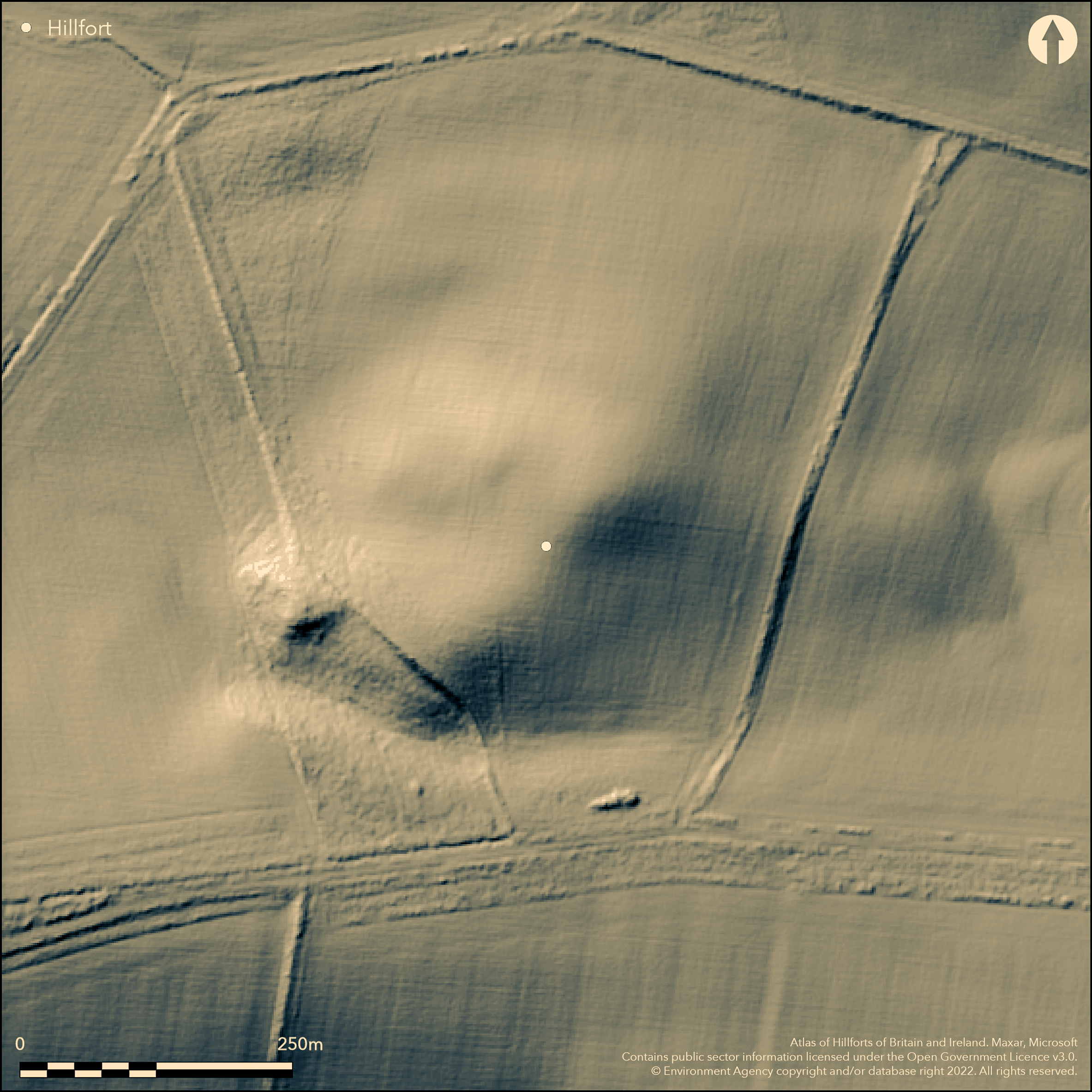
LiDAR 1m DTM Hillshade
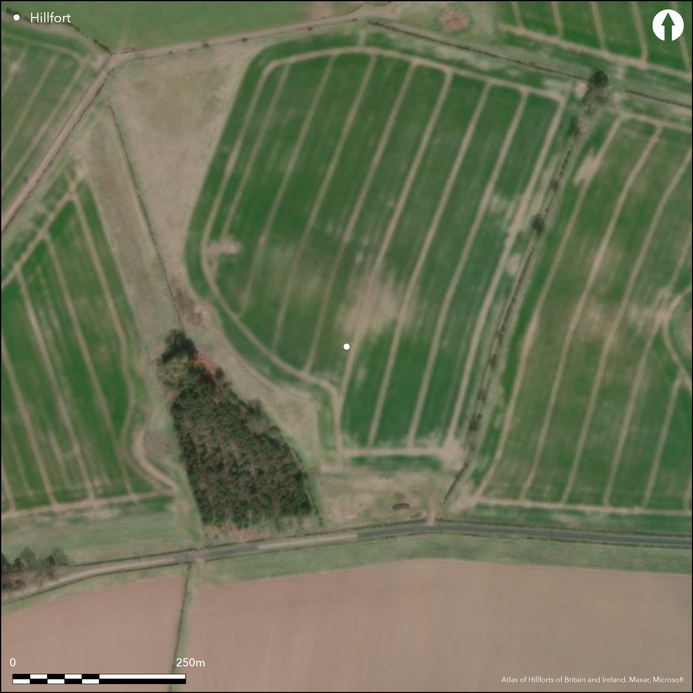
Satellite Imagery
LiDAR 1m DTM Hillshade
Satellite Imagery
Scroll left/right to view further images.
HER: Northumberland 12858 (None)
NMR: NT 93 NW 100 (1374897)
SM: None
NGR: NT 9429 3957
X: 394290 Y: 639570 (OSGB36)
The cropmarks of a large approximately oval-shaped enclosure, probably once a hillfort, 700m to the NW of Slainsfield. It occupies a prominent position at 110m OD on the summit of Broomie Knowe. The cropmarks show two broadly concentric ditches spaced 10-15m apart (Passmore and Waddington 2012, 74). It lies under woodland plantation in the SE but is estimated at 110m NW to SE by 140m transversely, enclosing approximately 0.98ha. The outer ditch is markedly broader than the inner ditch and might indicate the site developed over a number of years, as seen at Murton High Crags (Atlas No. 0586). The inner ditch cannot be traced around the southern perimeter. Three causeways are visible in the E, NE and NNE across the outer ditch, the one in the NNE having an out-turned ditch terminal in the NE. No internal features are recorded. The site was discovered as cropmarks on aerial photographs and does not appear to be recorded on OS mapping. Minimal investigations and undated.
Citizen Science: ✗
Reliability of Data: Confirmed
Reliability of Interpretation: Confirmed
X: -232912 Y: 7488989 (EPSG: 3857)
Longitude: -2.092287948321041 Latitude: 55.64966980318835 (EPSG:4326)
Country: England
Current County or Unitary Authority: Northumberland
Historic County: Northumberland
Current Parish/Community/Council/Townland: Ford
Inner ditch peters out on the S
| Extant | ✗ |
| Cropmark | ✓ |
| Likely Destroyed | ✗ |
Under woodland in the SE
| Woodland | ✗ |
| Commercial Forestry Plantation | ✓ |
| Parkland | ✗ |
| Pasture (Grazing) | ✗ |
| Arable | ✓ |
| Scrub/Bracken | ✗ |
| Bare Outcrop | ✗ |
| Heather/Moorland | ✗ |
| Heath | ✗ |
| Built-up | ✗ |
| Coastal Grassland | ✗ |
| Other | ✗ |
A hillfort lying on level ground at 110m OD on the summit of Broomie Knowe
| Contour Fort | ✗ |
| Partial Contour Fort | ✗ |
| Promontory Fort | ✗ |
| Hillslope Fort | ✗ |
| Level Terrain Fort | ✓ |
| Marsh Fort | ✗ |
| Multiple Enclosure Fort | ✗ |
| Hilltop | ✓ |
| Coastal Promontory | ✗ |
| Inland Promontory | ✗ |
| Valley Bottom | ✗ |
| Knoll/Hillock/Outcrop | ✗ |
| Ridge | ✗ |
| Cliff/Plateau-edge/Scarp | ✗ |
| Hillslope | ✗ |
| Lowland | ✗ |
| Spur | ✗ |
Dominant Topographic Feature: Summit of Broomie Knowe
| North | ✗ |
| Northeast | ✗ |
| East | ✗ |
| Southeast | ✗ |
| South | ✗ |
| Southwest | ✗ |
| West | ✗ |
| Northwest | ✗ |
| Level | ✓ |
Altitude: 110.0m
N/A
Undated - identified from aerial photographs only
Reliability: D - None
| Pre 1200BC | ✗ |
| 1200BC - 800BC | ✗ |
| 800BC - 400BC | ✗ |
| 400BC - AD50 | ✗ |
| AD50 - AD400 | ✗ |
| AD400 - AD 800 | ✗ |
| Post AD800 | ✗ |
| Unknown | ✓ |
| Pre Hillfort: | None |
| Post Hillfort: | None |
Mapped from the air as part of the Milfield Geoarchaeology Project. - archive object MD000293. Transcription in Passmore and Waddington (2012, 74)
| Other (None): | Transcription |
No internal feautes have been identfied
Springs and streams in the vicinity
| None | ✓ |
| Spring | ✗ |
| Stream | ✗ |
| Pool | ✗ |
| Flush | ✗ |
| Well | ✗ |
| Other | ✗ |
None
| No Known Features | ✓ |
| Round Stone Structures | ✗ |
| Rectangular Stone Structures | ✗ |
| Curvilinear Platforms | ✗ |
| Other Roundhouse Evidence | ✗ |
| Pits | ✗ |
| Quarry Hollows | ✗ |
| Other | ✗ |
None
| No Known Excavation | ✓ |
| Pits | ✗ |
| Postholes | ✗ |
| Roundhouses | ✗ |
| Rectangular Structures | ✗ |
| Roads/Tracks | ✗ |
| Quarry Hollows | ✗ |
| Other | ✗ |
| Nothing Found | ✗ |
None
| No Known Geophysics | ✓ |
| Pits | ✗ |
| Roundhouses | ✗ |
| Rectangular Structures | ✗ |
| Roads/Tracks | ✗ |
| Quarry Hollows | ✗ |
| Other | ✗ |
| Nothing Found | ✗ |
None
| No Known Finds | ✓ |
| Pottery | ✗ |
| Metal | ✗ |
| Metalworking | ✗ |
| Human Bones | ✗ |
| Animal Bones | ✗ |
| Lithics | ✗ |
| Environmental | ✗ |
| Other | ✗ |
None
| APs Not Checked | ✗ |
| None | ✓ |
| Roundhouses | ✗ |
| Rectangular Structures | ✗ |
| Pits | ✗ |
| Postholes | ✗ |
| Roads/Tracks | ✗ |
| Other | ✗ |
Three causeways are visible in the E, NE and NNE across the outer ditch, the the one in the NNE having an out-turned ditch terminal in the NE
| 3: | It is uncertain if 2 and 3 are original |
| 2: | None |
Guard Chambers: ✗
Chevaux de Frise: ✗
| 1. Out-turned (North east): | NNE; terminal out-turned on eastern side |
| 1. Simple Gap (North east): | NNE |
| 2. Simple Gap (North east): | None |
| 3. Simple Gap (East): | None |
Two broadly concentric ditches spaced 10-15m apart. Estimated at 110m NW to SE by 140m transversely, enclosing approximately 0.98ha. The outer ditch is markedly broader than the inner ditch and might indicate the site developed over a number of years. The inner ditch cannot be traced around the southern perimeter.
| Area 1: | 0.98ha. |
| Total: | 0.98ha. |
Total Footprint Area: Noneha.
None
| ✗ | None |
| ✗ | Ditches only |
| NE Quadrant: | 2 |
| SE Quadrant: | 2 |
| SW Quadrant: | 2 |
| NW Quadrant: | 2 |
| Total: | 2 |
| Partial Univallate | ✗ |
| Univallate | ✗ |
| Partial Bivallate | ✗ |
| Bivallate | ✓ |
| Partial Multivallate | ✗ |
| Multivallate | ✗ |
| Unknown | ✗ |
| Partial Univallate | ✗ |
| Univallate | ✗ |
| Partial Bivallate | ✗ |
| Bivallate | ✗ |
| Partial Multivallate | ✗ |
| Multivallate | ✗ |
None
| None | ✓ |
| Earthen Bank | ✗ |
| Stone Wall | ✗ |
| Rubble | ✗ |
| Wall-walk | ✗ |
| Evidence of Timber | ✗ |
| Vitrification | ✗ |
| Other Burning | ✗ |
| Palisade | ✗ |
| Counter Scarp Bank | ✗ |
| Berm | ✗ |
| Unfinished | ✗ |
| Other | ✗ |
None
| None | ✗ |
| Earthen Bank | ✗ |
| Stone Wall | ✗ |
| Murus Duplex | ✗ |
| Timber-framed | ✗ |
| Timber-laced | ✗ |
| Vitrification | ✗ |
| Other Burning | ✗ |
| Palisade | ✗ |
| Counter Scarp Bank | ✗ |
| Berm | ✗ |
| Unfinished | ✗ |
| No Known Excavation | ✓ |
| Other | ✗ |
| ✗ | None |
| ✓ | None |
Number of Ditches: 2
| ✗ | None |
Passmore, D.G. and Waddington, C. 2012. Archaeology and Environment in Northumberland. Till-Tweed studies, Vol 2. Oxbow
Atlas of Hillforts:
Wikidata:
This work is licensed under CC BY-SA 4.0

 and should be cited as:
Lock, Gary and Ralston, Ian. 2024. Atlas of Hillforts of Britain and Ireland. Available at: https://hillforts.arch.ox.ac.uk
Document Version 1.1