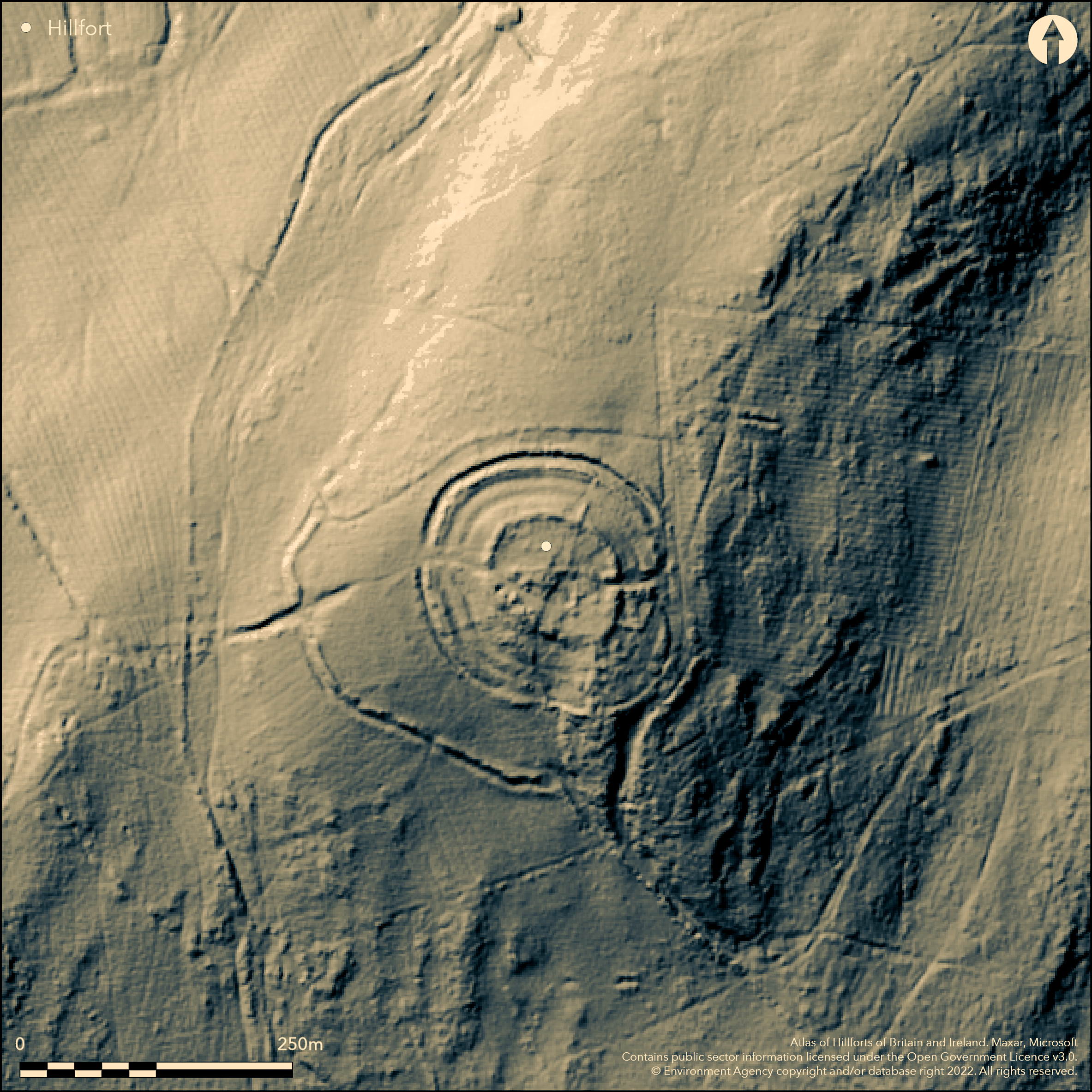
LiDAR 1m DTM Hillshade
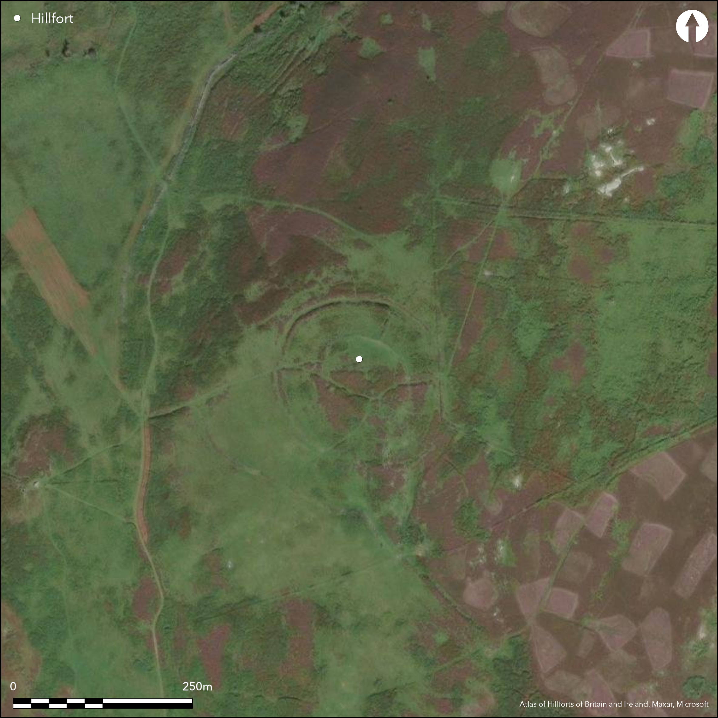
Satellite Imagery
LiDAR 1m DTM Hillshade
Satellite Imagery
Scroll left/right to view further images.
HER: Northumberland 10736 (None)
NMR: NZ 09 NE 2 (21173)
SM: 1017196
NGR: NZ 0548 9925
X: 405480 Y: 599250 (OSGB36)
Situated on a prominent spur of the Simonside Hills at 268m OD, a multivallate hillfort lying 700m to the S of Whittondean. The location offers commanding views across Coquetdale, Druridge Bay and Coquet Island and to the hillfort of Tosson Burgh (Atlas No. 0595). Sub-circular in plan, it measures 70m NW-SE by 45m transversely and comprises three earth and stone ramparts and two ditches. The inner enclosure is almost D-shaped measuring approximately 70m NW-SE by 45m transversely, enclosing 0.33ha. The innermost ditch ranges from 6-9m wide and 0.6-1.3m deep. The outermost ramparts are the most prominent with the V-shaped ditch measuring up to 9m wide and between 1.4-2.5m deep in places. A counterscarp bank lies beyond the outer ditch surviving up to 1.3m high. In the SW the outer ditch encroaches upon and crosses the alignment of the inner ditch, suggesting the inner ditch is not associated with the later phases of the fort (Topping 1993). An irregular berm between the two ramparts measuring 1.5-4.6m wide has been subdivided, possibly for use as a stock enclosure. Two hut circles lie within one of the divisions (Hedley 1889). Opposing embanked entrances lie in the E and W, the western entrance being 3.5m wide. It is marked with substantial facing stones where it cuts through the inner rampart although these are considered by Oswald et al. (2006) to be a later Roman Iron Age modification. The less well-preserved eastern entrance is 4.8m wide marked out by several large boulders. Internally the ground lies at two levels divided by a natural E-W scarp, with the N rising up to 1.3m above that in the S. Three stone founded huts 4.5-5.6m in diameter have been recorded and sub-circular depressions against the southern rampart are possibly further houses. In the SE the ramparts have been levelled and a Romano-British settlement comprising hut circles set within courtyards, abut the outer face of the inner rampart. Externally, a substantial earthwork on the S and W sides of the hillfort is possibly an outwork. The earthworks are considered to have had six phases of development (Oswald et al. 2006: 59, Figure 4.25). In phase 1 it comprised a single earth bank and ditch with an entrance in the W; phase 2 the original bank was enclosed by a larger bank and ditch; phase 3 the largest earth bank and ditch was created enclosing an area 140m across; phase 4 the D-shaped stone enclosure was constructed inside the phase 1 enclosure with an entrance in the E, marking a change in the how the hillfort was used. Phases 5 and 6 relate to the Romano-British settlement that overlie the Iron Age features. The site is recorded on 1856-65 OS mapping. A number of cup and ring-marked stones lie in the vicinity.
Citizen Science: ✗
Reliability of Data: Confirmed
Reliability of Interpretation: Confirmed
X: -213205 Y: 7417840 (EPSG: 3857)
Longitude: -1.9152558332837992 Latitude: 55.2873738340181 (EPSG:4326)
Country: England; None
Current County or Unitary Authority: Northumberland
Historic County: Northumberland
Current Parish/Community/Council/Townland: Brinkburn and Hesleyhurst; Hesleyhurst/Hollnghill, Whitton and Tosson/Hesleyhurst and Whtton and Tosson/Hollinghill
None
| Extant | ✓ |
| Cropmark | ✗ |
| Likely Destroyed | ✗ |
Upland heathland, bracken covered in summer
| Woodland | ✗ |
| Commercial Forestry Plantation | ✗ |
| Parkland | ✗ |
| Pasture (Grazing) | ✗ |
| Arable | ✗ |
| Scrub/Bracken | ✓ |
| Bare Outcrop | ✗ |
| Heather/Moorland | ✗ |
| Heath | ✓ |
| Built-up | ✗ |
| Coastal Grassland | ✗ |
| Other | ✗ |
A contour fort lying at 268m OD on the summit of a prominent spur of the Simonside Hills Garleigh Moor.
| Contour Fort | ✓ |
| Partial Contour Fort | ✗ |
| Promontory Fort | ✗ |
| Hillslope Fort | ✗ |
| Level Terrain Fort | ✗ |
| Marsh Fort | ✗ |
| Multiple Enclosure Fort | ✓ |
| Hilltop | ✓ |
| Coastal Promontory | ✗ |
| Inland Promontory | ✗ |
| Valley Bottom | ✗ |
| Knoll/Hillock/Outcrop | ✗ |
| Ridge | ✗ |
| Cliff/Plateau-edge/Scarp | ✗ |
| Hillslope | ✗ |
| Lowland | ✗ |
| Spur | ✓ |
Dominant Topographic Feature: Prominent spur
| North | ✗ |
| Northeast | ✗ |
| East | ✓ |
| Southeast | ✗ |
| South | ✗ |
| Southwest | ✗ |
| West | ✗ |
| Northwest | ✗ |
| Level | ✗ |
Altitude: 268.0m
Lies close to the junction of Hesleyhurst/Hollnghill, Whitton and Tosson/Hesleyhurst and Whtton and Tosson/Hollinghill parish boundaries
Boundary Type: Parish/Townland
Undated, presumed Iron Age based on morphology and continuing in use into the Roman Iron Age
Reliability: D - None
| Pre 1200BC | ✗ |
| 1200BC - 800BC | ✗ |
| 800BC - 400BC | ✗ |
| 400BC - AD50 | ✗ |
| AD50 - AD400 | ✗ |
| AD400 - AD 800 | ✗ |
| Post AD800 | ✗ |
| Unknown | ✓ |
| Pre Hillfort: | Stones displaying rock art present in the surrounding landscape |
| Post Hillfort: | Romano-British settlement activity and modification to Iron Age domestic features |
| Morphology/Earthwork/Typology: | None |
Recorded on 1856-65 OS mapping. General reference in Hope Dodds (1940); Archaeology Division Field Investigations in 1957 and 1971. RCHME 1:1000 earthwork survey for Northumberland National Park (MacKay and Topping 1990), ref. no. 662360. Scheduled
| 1st Identified Written Reference (1940): | None |
| Other (1957): | Field investigation |
| Other (1971): | Field investigation |
| Earthwork Survey (1990): | MacKay and Topping (1990) |
| Other (1999): | Scheduled |
| 1st Identified Map Depiction (None): | None |
Internally the ground lies at two levels divided by a natural E-W scarp, with the N rising up to 1.3m above that in the S. Three stone founded huts 4.5-5.6m in diameter have been recorded, sub-circular depressions against the southern rampart are possibly further houses. In the SE the ramparts have been levelled and a Romano-British settlement comprising hut circles set within courtyards, abuts the outer face of the inner rampart.
None
| None | ✓ |
| Spring | ✗ |
| Stream | ✗ |
| Pool | ✗ |
| Flush | ✗ |
| Well | ✗ |
| Other | ✗ |
Courtyards. Subcircular depressions.
| No Known Features | ✗ |
| Round Stone Structures | ✓ |
| Rectangular Stone Structures | ✗ |
| Curvilinear Platforms | ✗ |
| Other Roundhouse Evidence | ✓ |
| Pits | ✗ |
| Quarry Hollows | ✗ |
| Other | ✓ |
None
| No Known Excavation | ✓ |
| Pits | ✗ |
| Postholes | ✗ |
| Roundhouses | ✗ |
| Rectangular Structures | ✗ |
| Roads/Tracks | ✗ |
| Quarry Hollows | ✗ |
| Other | ✗ |
| Nothing Found | ✗ |
None
| No Known Geophysics | ✓ |
| Pits | ✗ |
| Roundhouses | ✗ |
| Rectangular Structures | ✗ |
| Roads/Tracks | ✗ |
| Quarry Hollows | ✗ |
| Other | ✗ |
| Nothing Found | ✗ |
None
| No Known Finds | ✓ |
| Pottery | ✗ |
| Metal | ✗ |
| Metalworking | ✗ |
| Human Bones | ✗ |
| Animal Bones | ✗ |
| Lithics | ✗ |
| Environmental | ✗ |
| Other | ✗ |
None
| APs Not Checked | ✓ |
| None | ✗ |
| Roundhouses | ✗ |
| Rectangular Structures | ✗ |
| Pits | ✗ |
| Postholes | ✗ |
| Roads/Tracks | ✗ |
| Other | ✗ |
Opposing embanked entrances in the E and W, the western entrance being 3.5m wide marked with substantial facing stones where the entrance cuts through the inner rampart. These are possibly a later Roman Iron Age modification (Oswald et al. 2006). The less well-preserved eastern entrance is 4.8m wide marked out by several large boulders.
| 2: | None |
| 2: | None |
Guard Chambers: ✗
Chevaux de Frise: ✗
| 1. Oblique (West): | Inner rampart (phase 1). |
| 1. Oblique (West): | Middle rampart (phase 2) |
| 1. Oblique (West): | Outer rampart (Phase 3) |
| 2. Simple Gap (East): | Phase 4 |
Sub-circular in plan measuring 70m NW-SE by 45m transversely. It comprises three earth and stone ramparts and two ditches. The inner enclosure is almost D-shaped measuring approximately 70m NW-SE by 45m transversely. The innermost ditch ranges from 6-9m wide and 0.6-1.3m deep. The outermost defences are the most prominent with the V-shaped ditch measuring up to 9m wide and between 1.4-2.5m deep in places. A counterscarp bank lies beyond the outer ditch surviving up to 1.3m high. In the SW, the outer ditch encroaches upon and crosses the alignment of the inner ditch, suggesting the inner ditch is not associated with the later phases of the fort (Topping 1993). An irregular berm between the two ramparts measuring 1.5-4.6m wide has been subdivided, possibly for use as a stock enclosure. Stones displaying rockart were broken up and used in the construction of the rampart (Oswald et al. 2006, 37)
| Area 1: | 0.33ha. |
| Total: | 0.33ha. |
Total Footprint Area: 1.74ha.
None
| ✓ | None |
| ✓ | None |
| NE Quadrant: | 3 |
| SE Quadrant: | 3 |
| SW Quadrant: | 3 |
| NW Quadrant: | 3 |
| Total: | 3 |
| Partial Univallate | ✗ |
| Univallate | ✗ |
| Partial Bivallate | ✗ |
| Bivallate | ✗ |
| Partial Multivallate | ✗ |
| Multivallate | ✓ |
| Unknown | ✗ |
| Partial Univallate | ✗ |
| Univallate | ✓ |
| Partial Bivallate | ✗ |
| Bivallate | ✓ |
| Partial Multivallate | ✗ |
| Multivallate | ✓ |
None
| None | ✗ |
| Earthen Bank | ✓ |
| Stone Wall | ✓ |
| Rubble | ✗ |
| Wall-walk | ✗ |
| Evidence of Timber | ✗ |
| Vitrification | ✗ |
| Other Burning | ✗ |
| Palisade | ✗ |
| Counter Scarp Bank | ✓ |
| Berm | ✗ |
| Unfinished | ✗ |
| Other | ✗ |
None
| None | ✗ |
| Earthen Bank | ✗ |
| Stone Wall | ✗ |
| Murus Duplex | ✗ |
| Timber-framed | ✗ |
| Timber-laced | ✗ |
| Vitrification | ✗ |
| Other Burning | ✗ |
| Palisade | ✗ |
| Counter Scarp Bank | ✗ |
| Berm | ✗ |
| Unfinished | ✗ |
| No Known Excavation | ✓ |
| Other | ✗ |
| ✗ | None |
| ✓ | None |
Number of Ditches: 2
| ✗ | None |
Dodds, M.H., 1940. A History of Northumberland, Volume 15 (Newcastle upon Tyne), 30-2.
Hedley, R.C. 1889. The Pre-Historic Camps of Northumberland, Lordenshaws or Lurganshaws. Archaeol Aeliana. New Series. Vol. 13, 226-29
Mackay, D. and Topping, P. 1990. Lordenshaws Hillfort and Environs, Northumberland. RCHME. Unpublished
Oswald, A. Ainsworth, S. and Pearson, T. 2006 Hillforts: Prehistoric Strongholds of Northumberland National Park. English Heritage
Topping, P. 1993 Lordenshaws Hillfort and its Environs. Archaeol Aeliana ser 5 - Vol: 21, 15-27
Welfare, H. 1991. Royal Commission on the Historic Monuments of England: Field Survey in Northumberland.RCHME. Newcastle-Upon-Tyne
Atlas of Hillforts:
Wikidata:
This work is licensed under CC BY-SA 4.0

 and should be cited as:
Lock, Gary and Ralston, Ian. 2024. Atlas of Hillforts of Britain and Ireland. Available at: https://hillforts.arch.ox.ac.uk
Document Version 1.1