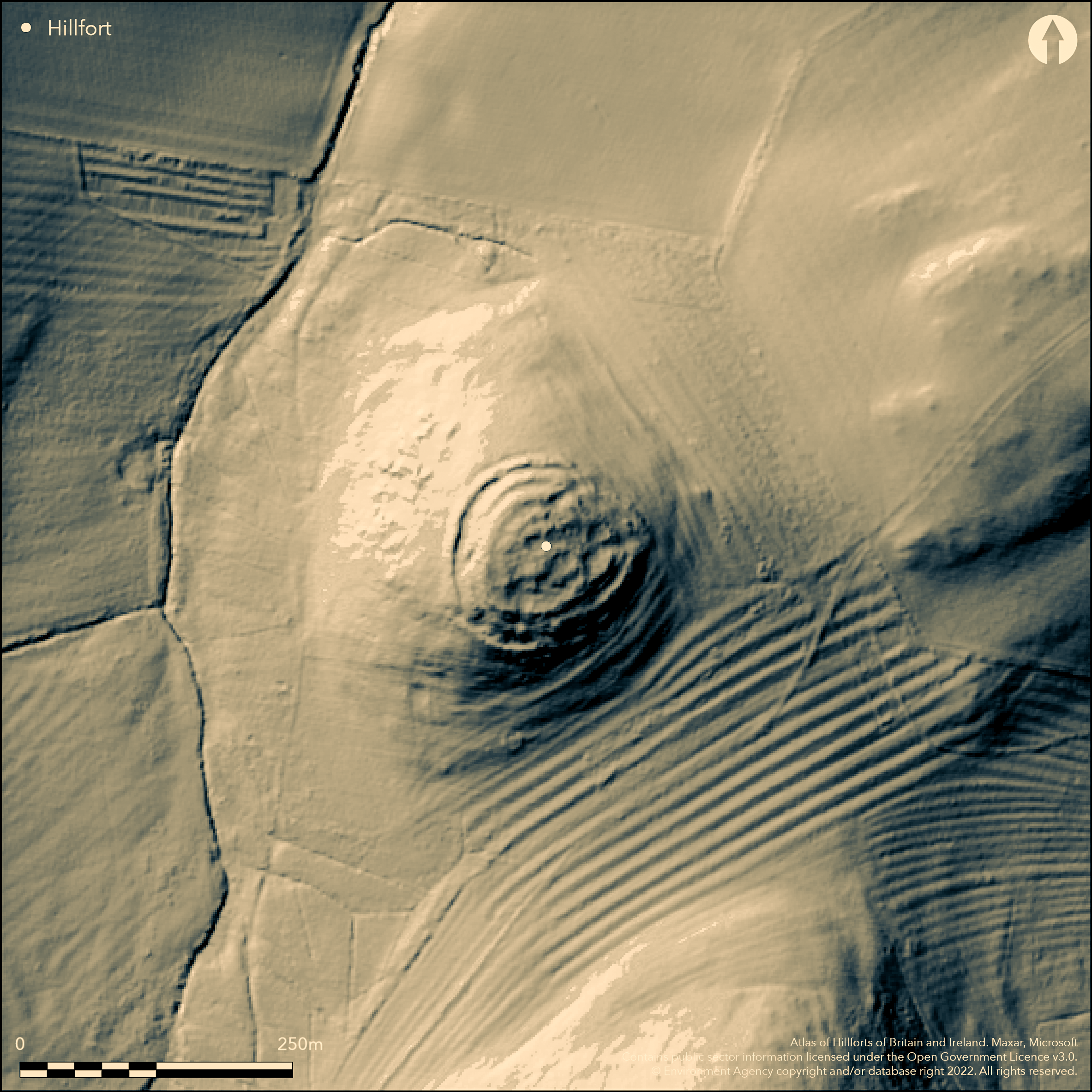
LiDAR 1m DTM Hillshade
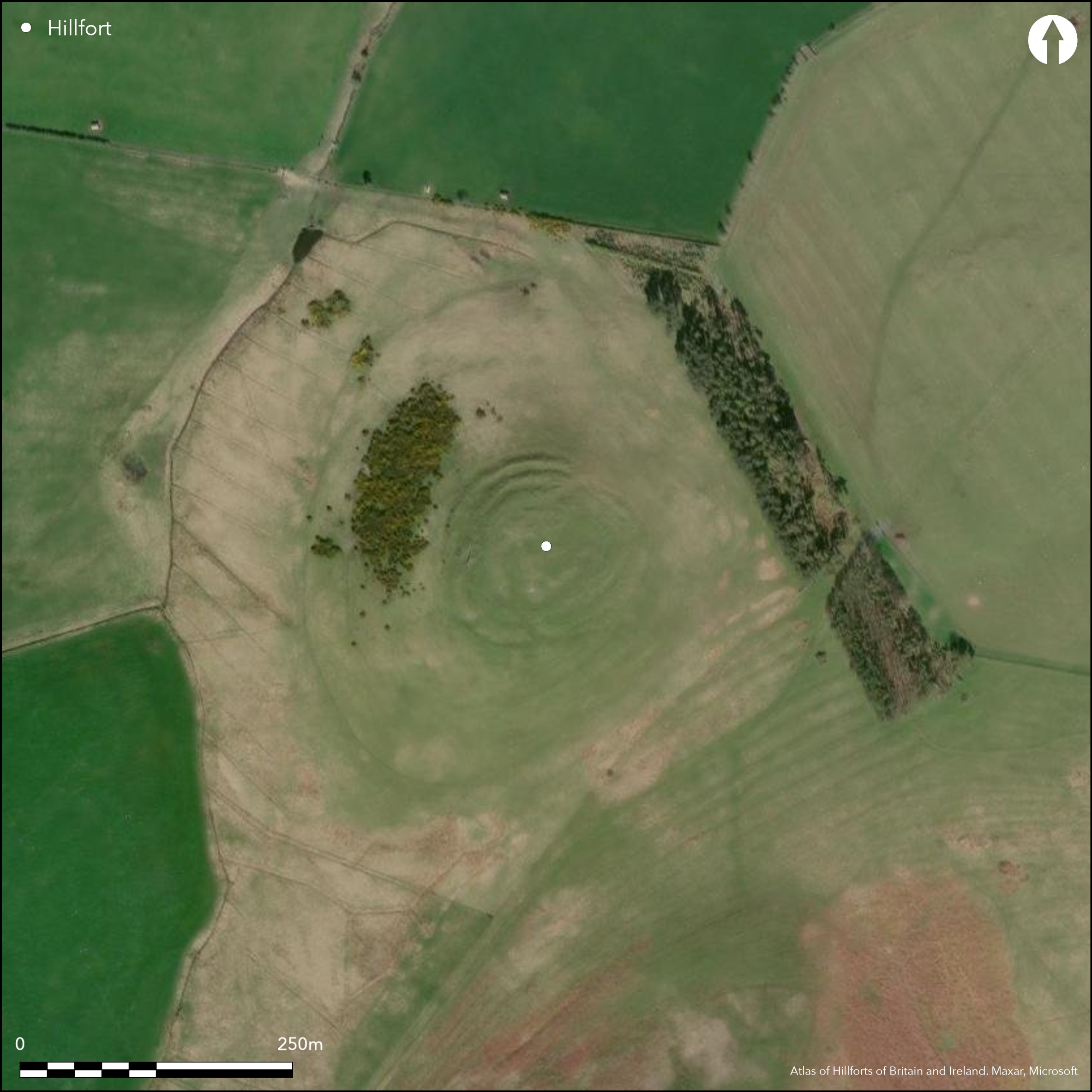
Satellite Imagery
LiDAR 1m DTM Hillshade
Satellite Imagery
Scroll left/right to view further images.
HER: Northumberland 3193 (None)
NMR: NU 01 SW 4 (5341)
SM: 1006542
NGR: NU 03142 14673
X: 403142 Y: 614673 (OSGB36)
A multivallate hillfort lying partially on the summit of Castle Knowe at 198m OD, 483m SW of Clinch. Oval in plan it measures 60m N-S by 75m E-W with steep slopes in the N and W. it is overlooked by Gibbs Hill (Atlas No. 4349) and West Hill (Atlas No. 0573). Three roughly concentric ramparts have been formed by scarping the natural slopes, enclosing 0.28ha and suggestions of two ditches. The middle and inner ramparts survive up to 2m high externally but only as faint scarps internally. They merge together in the W. The outer rampart stands 2.8m high externally and 0.9m internally in the W. Entrances lie in the E, N and S. Only the eastern entrance with inturned ramparts appears to be original, the other two are created by breaking obliquely through the ramparts. Within the interior seven or more hut circles with diameters of between 3.8 to 6.5m with a larger hut circle 8.5m in diameter near the centre. Four of the hut circles near the top of the knoll are partly rock-cut. Three intercutting huts indicate more than one phase of occupation. Some damage has occurred through quarrying. Shown on 1856-65 OS mapping. Minimal investigations, undated.
Citizen Science: ✗
Reliability of Data: Confirmed
Reliability of Interpretation: Confirmed
X: -217285 Y: 7444983 (EPSG: 3857)
Longitude: -1.9519005661237772 Latitude: 55.42598195684819 (EPSG:4326)
Country: England
Current County or Unitary Authority: Northumberland
Historic County: Northumberland
Current Parish/Community/Council/Townland: Ingram
None
| Extant | ✓ |
| Cropmark | ✗ |
| Likely Destroyed | ✗ |
None
| Woodland | ✗ |
| Commercial Forestry Plantation | ✗ |
| Parkland | ✗ |
| Pasture (Grazing) | ✓ |
| Arable | ✗ |
| Scrub/Bracken | ✗ |
| Bare Outcrop | ✗ |
| Heather/Moorland | ✗ |
| Heath | ✗ |
| Built-up | ✗ |
| Coastal Grassland | ✗ |
| Other | ✗ |
A partial contour fort lying on the north-westerly slope of Castle Knowe at approximately 198m OD
| Contour Fort | ✗ |
| Partial Contour Fort | ✓ |
| Promontory Fort | ✗ |
| Hillslope Fort | ✓ |
| Level Terrain Fort | ✗ |
| Marsh Fort | ✗ |
| Multiple Enclosure Fort | ✗ |
| Hilltop | ✓ |
| Coastal Promontory | ✗ |
| Inland Promontory | ✗ |
| Valley Bottom | ✗ |
| Knoll/Hillock/Outcrop | ✗ |
| Ridge | ✗ |
| Cliff/Plateau-edge/Scarp | ✗ |
| Hillslope | ✓ |
| Lowland | ✗ |
| Spur | ✗ |
Dominant Topographic Feature: Castle Knowe
| North | ✗ |
| Northeast | ✗ |
| East | ✗ |
| Southeast | ✗ |
| South | ✗ |
| Southwest | ✗ |
| West | ✗ |
| Northwest | ✓ |
| Level | ✗ |
Altitude: 198.0m
N/A
Undated, presumed Iron Age
Reliability: D - None
| Pre 1200BC | ✗ |
| 1200BC - 800BC | ✗ |
| 800BC - 400BC | ✗ |
| 400BC - AD50 | ✗ |
| AD50 - AD400 | ✗ |
| AD400 - AD 800 | ✗ |
| Post AD800 | ✗ |
| Unknown | ✓ |
| Pre Hillfort: | None |
| Post Hillfort: | Quarrying |
| Morphology/Earthwork/Typology: | None |
The site is recorded on 1856-65 OS mapping. General reference in MacLauchlan (1867), Field investigations in 1957, 1969 and 1976. 1988 included in the SE Cheviots Project. Scheduled.
| 1st Identified Written Reference (1867): | (MacLauchlan 1867) |
| Other (1934): | Scheduled |
| Other (1957): | Field investigation |
| Other (1969): | Field investigation |
| Other (1976): | Field investigation |
| Earthwork Survey (1988): | SE Cheviots Project |
| 1st Identified Map Depiction (None): | None |
Seven or more hut circles with diameters of between 3.8 to 6.5m with a larger hut circle 8.5m in diameter near the centre. Three intercutting huts indicate more than one phase of occupation.
None
| None | ✓ |
| Spring | ✗ |
| Stream | ✗ |
| Pool | ✗ |
| Flush | ✗ |
| Well | ✗ |
| Other | ✗ |
None
| No Known Features | ✗ |
| Round Stone Structures | ✓ |
| Rectangular Stone Structures | ✗ |
| Curvilinear Platforms | ✗ |
| Other Roundhouse Evidence | ✗ |
| Pits | ✗ |
| Quarry Hollows | ✗ |
| Other | ✗ |
None
| No Known Excavation | ✓ |
| Pits | ✗ |
| Postholes | ✗ |
| Roundhouses | ✗ |
| Rectangular Structures | ✗ |
| Roads/Tracks | ✗ |
| Quarry Hollows | ✗ |
| Other | ✗ |
| Nothing Found | ✗ |
None
| No Known Geophysics | ✓ |
| Pits | ✗ |
| Roundhouses | ✗ |
| Rectangular Structures | ✗ |
| Roads/Tracks | ✗ |
| Quarry Hollows | ✗ |
| Other | ✗ |
| Nothing Found | ✗ |
None
| No Known Finds | ✓ |
| Pottery | ✗ |
| Metal | ✗ |
| Metalworking | ✗ |
| Human Bones | ✗ |
| Animal Bones | ✗ |
| Lithics | ✗ |
| Environmental | ✗ |
| Other | ✗ |
None
| APs Not Checked | ✓ |
| None | ✗ |
| Roundhouses | ✗ |
| Rectangular Structures | ✗ |
| Pits | ✗ |
| Postholes | ✗ |
| Roads/Tracks | ✗ |
| Other | ✗ |
Possible entrances lie in the E, N and S although only the eastern entrance with slight in-turned ramparts appears to be original, the other two created later by breaking obliquely through the ramparts.
| 9: | None |
| 2: | None |
Guard Chambers: ✗
Chevaux de Frise: ✗
| 1. In-turned (East): | None |
| 1. In-turned (East): | None |
| 1. In-turned (East): | None |
Oval in plan it measures 60m N-S by 75m E-W. Three roughly concentric ramparts have been formed by scarping the natural slopes, suggestions of two ditches. The middle and inner ramparts survive up to 2m high externally but only as faint scarps internally. They merge together in the W. The outer rampart stands 2.8m high externally and 0.9m internally in the W.
| Area 1: | 0.28ha. |
| Total: | 0.28ha. |
Total Footprint Area: 0.9ha.
None
| ✗ | Whole site footprint estimated from satellite imagery |
| ✗ | None |
| NE Quadrant: | 3 |
| SE Quadrant: | 3 |
| SW Quadrant: | 3 |
| NW Quadrant: | 3 |
| Total: | 3 |
| Partial Univallate | ✗ |
| Univallate | ✗ |
| Partial Bivallate | ✗ |
| Bivallate | ✗ |
| Partial Multivallate | ✗ |
| Multivallate | ✓ |
| Unknown | ✗ |
| Partial Univallate | ✗ |
| Univallate | ✗ |
| Partial Bivallate | ✗ |
| Bivallate | ✗ |
| Partial Multivallate | ✗ |
| Multivallate | ✗ |
None
| None | ✗ |
| Earthen Bank | ✓ |
| Stone Wall | ✗ |
| Rubble | ✓ |
| Wall-walk | ✗ |
| Evidence of Timber | ✗ |
| Vitrification | ✗ |
| Other Burning | ✗ |
| Palisade | ✗ |
| Counter Scarp Bank | ✗ |
| Berm | ✗ |
| Unfinished | ✗ |
| Other | ✗ |
None
| None | ✗ |
| Earthen Bank | ✗ |
| Stone Wall | ✗ |
| Murus Duplex | ✗ |
| Timber-framed | ✗ |
| Timber-laced | ✗ |
| Vitrification | ✗ |
| Other Burning | ✗ |
| Palisade | ✗ |
| Counter Scarp Bank | ✗ |
| Berm | ✗ |
| Unfinished | ✗ |
| No Known Excavation | ✓ |
| Other | ✗ |
| ✗ | None |
| ✓ | None |
Number of Ditches: 2
| ✗ | None |
Jobey, G.1965. Hillforts and Settlements in Northumberland. Archaeol Aeliana (4th Series) 43
MacLauchlan, H. 1867. Notes not included in the memoirs already published on Roman roads in Northumberland (London), 55
Atlas of Hillforts:
Wikidata:
This work is licensed under CC BY-SA 4.0![]()
![]()
![]() and should be cited as:
and should be cited as:
Lock, Gary and Ralston, Ian. 2024. Atlas of Hillforts of Britain and Ireland. Available at: https://hillforts.arch.ox.ac.uk
Document Version 1.1