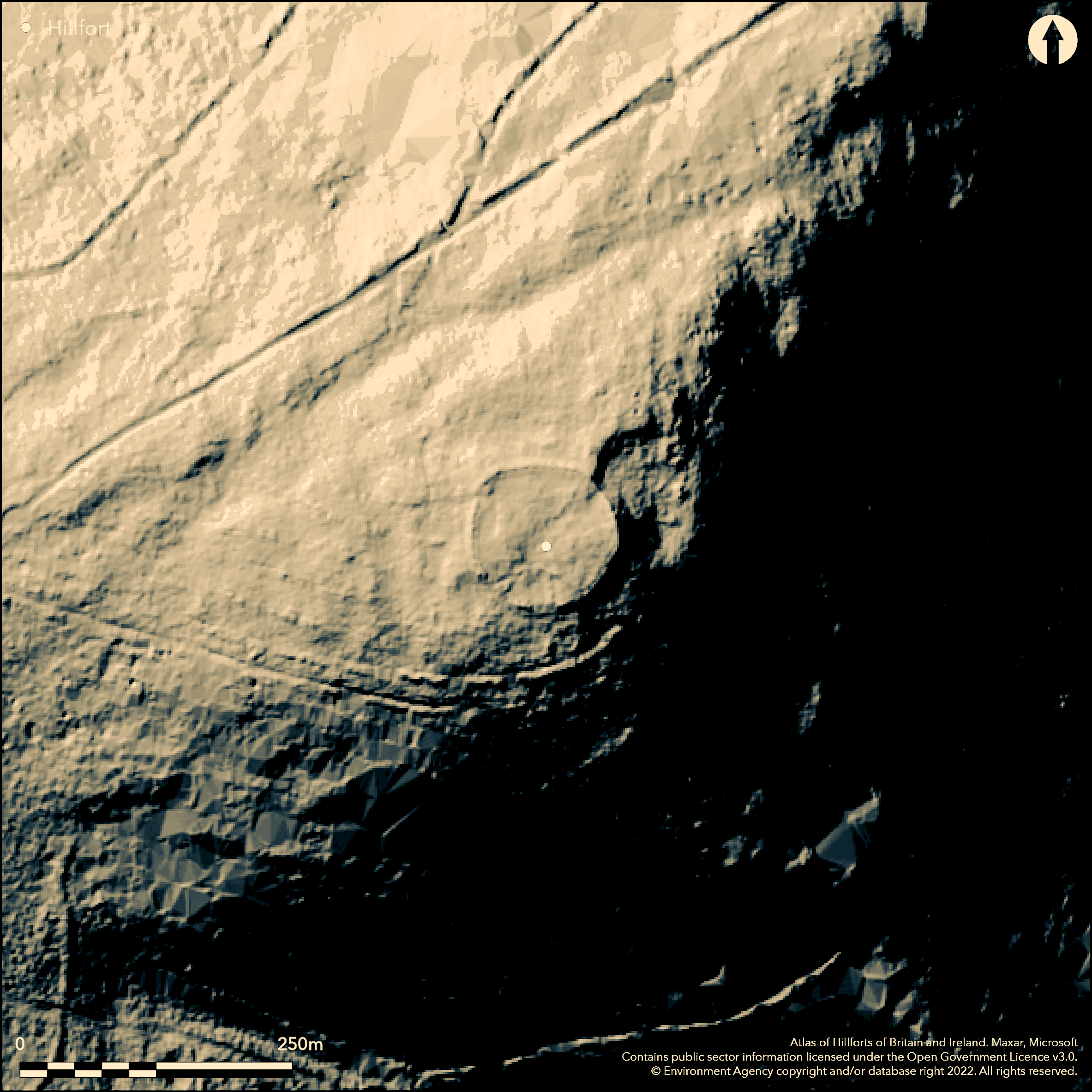
LiDAR 1m DTM Hillshade
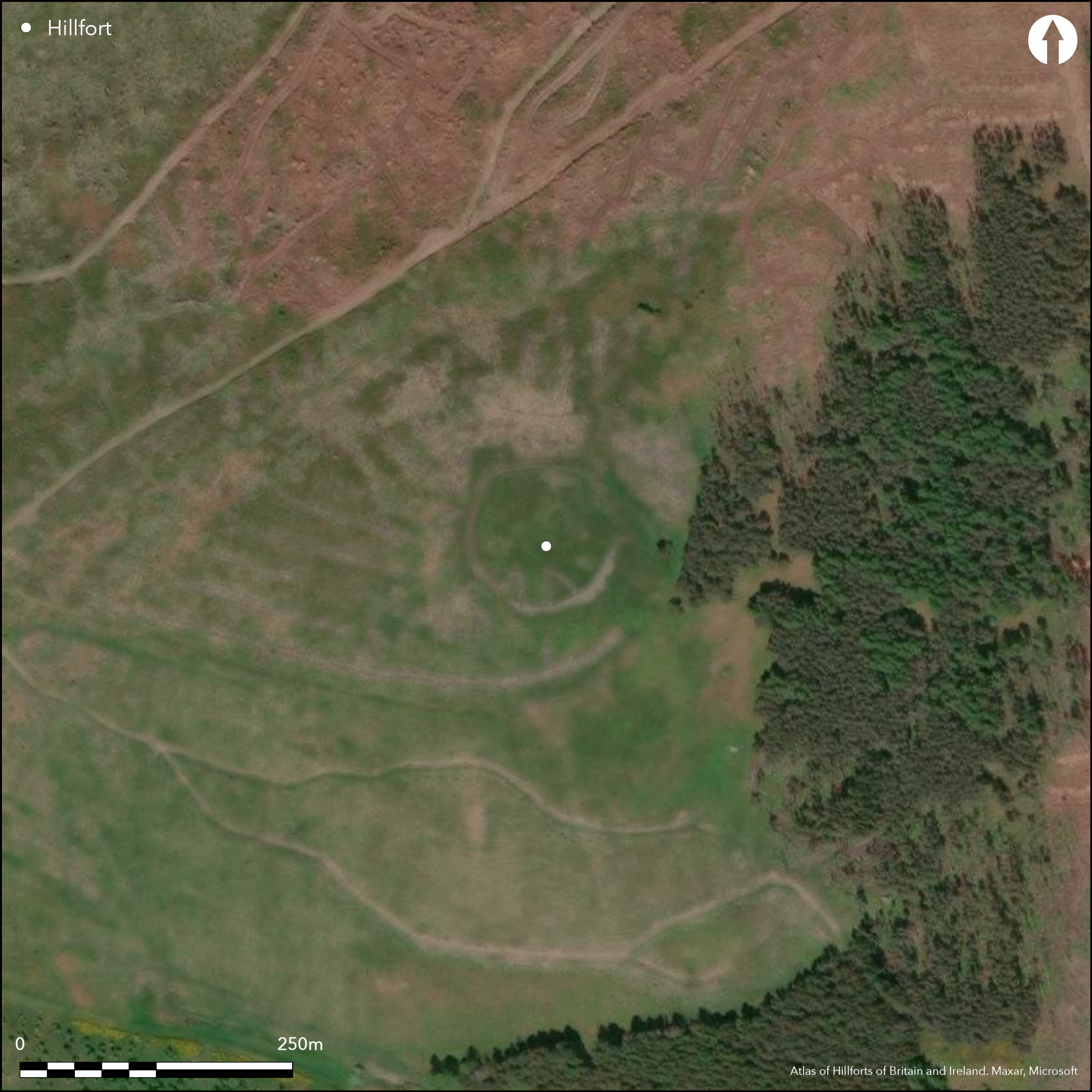
Satellite Imagery
LiDAR 1m DTM Hillshade
Satellite Imagery
Scroll left/right to view further images.
HER: Northumberland 569 (None)
NMR: NT 82 NE 5 (584)
SM: 1009529
NGR: NT 8842 2628
X: 388420 Y: 626280 (OSGB36)
A univallate hillfort lying 2.3km to the SW of Hethpool on the SE summit of Sinkside Hill. The enclosure is almost circular in plan comprising a single stone rampart measuring 72m N-S by 75m E-W enclosing 0.42ha. It lies on a level plateau at 329m OD on the W bank of the College Burn, where it commands extensive views to the N and S along the College Valley. The ground drops away steeply on all sides of the hill except in the SW where it extends towards a narrow saddle and is overlooked by higher ground. Today the ramparts survive mainly as core material 3.5m wide and a spread of tumbled stone. They are best preserved in the E and N where the internal wall stands at 0.9m high with a drystone external facing of large dressed stones which survives up to 5 courses. No evidence of a ditch. In the SE the ramparts have been overlain by medieval or later sheep pens, constructed with stone from the ramparts. A simple gap entrance 3m wide faced with large upright boulders set on edge at right angles to the rampart, lies in the NW. Timber and stone founded prehistoric hut circles with internal banks lie within the interior. The site is surrounded by coniferous woodland with the area around the hillfort left clear. A lack of grazing has led to the grass becoming tussocky, which might hide further internal features. It is scheduled as a defended enclosure. No excavation has taken place and it is undated. The hillfort is recorded on 1856-65 OS mapping. Scheduled as a defended settlement
Citizen Science: ✗
Reliability of Data: Confirmed
Reliability of Interpretation: Confirmed
X: -243233 Y: 7465444 (EPSG: 3857)
Longitude: -2.185001206587434 Latitude: 55.530147982133 (EPSG:4326)
Country: England
Current County or Unitary Authority: Northumberland
Historic County: Northumberland
Current Parish/Community/Council/Townland: Kirknewton
None
| Extant | ✓ |
| Cropmark | ✗ |
| Likely Destroyed | ✗ |
Tussocky grass
| Woodland | ✓ |
| Commercial Forestry Plantation | ✗ |
| Parkland | ✗ |
| Pasture (Grazing) | ✓ |
| Arable | ✗ |
| Scrub/Bracken | ✗ |
| Bare Outcrop | ✗ |
| Heather/Moorland | ✗ |
| Heath | ✗ |
| Built-up | ✗ |
| Coastal Grassland | ✗ |
| Other | ✓ |
A contour fort lying at 329m OD on level ground on the summit of Sinkside Hill.
| Contour Fort | ✓ |
| Partial Contour Fort | ✗ |
| Promontory Fort | ✗ |
| Hillslope Fort | ✗ |
| Level Terrain Fort | ✗ |
| Marsh Fort | ✗ |
| Multiple Enclosure Fort | ✗ |
| Hilltop | ✓ |
| Coastal Promontory | ✗ |
| Inland Promontory | ✗ |
| Valley Bottom | ✗ |
| Knoll/Hillock/Outcrop | ✗ |
| Ridge | ✗ |
| Cliff/Plateau-edge/Scarp | ✗ |
| Hillslope | ✗ |
| Lowland | ✗ |
| Spur | ✗ |
Dominant Topographic Feature: Summit of Sinkside Hill
| North | ✗ |
| Northeast | ✗ |
| East | ✗ |
| Southeast | ✗ |
| South | ✗ |
| Southwest | ✗ |
| West | ✗ |
| Northwest | ✗ |
| Level | ✓ |
Altitude: 329.0m
N/A
Undated, presumed Iron Age
Reliability: D - None
| Pre 1200BC | ✗ |
| 1200BC - 800BC | ✗ |
| 800BC - 400BC | ✗ |
| 400BC - AD50 | ✗ |
| AD50 - AD400 | ✗ |
| AD400 - AD 800 | ✗ |
| Post AD800 | ✗ |
| Unknown | ✓ |
| Pre Hillfort: | None |
| Post Hillfort: | Medieval or post medieval sheep stell |
| Morphology/Earthwork/Typology: | None |
Recorded on 1856-65 OS mapping, general reference in MacLauchlan (1919-22). Surveyed by Jobey 1965. Field investigation in 1967. English Heritage established two permanent survey markers, marked by brass rivets, using GPS survey as part of the Discovering our Hillfort Heritage Project. Scheduled
| Earthwork Survey (1965): | G. Jobey |
| Other (1967): | Field investigation |
| Other (1969): | Scheduled |
| 1st Identified Map Depiction (None): | None |
| 1st Identified Written Reference (None): | None |
| Other (None): | Established survey markers |
Timber and stone founded prehistoric hut circles with internal banks
College burn lies to the E
| None | ✓ |
| Spring | ✗ |
| Stream | ✗ |
| Pool | ✗ |
| Flush | ✗ |
| Well | ✗ |
| Other | ✗ |
None
| No Known Features | ✗ |
| Round Stone Structures | ✓ |
| Rectangular Stone Structures | ✗ |
| Curvilinear Platforms | ✗ |
| Other Roundhouse Evidence | ✓ |
| Pits | ✗ |
| Quarry Hollows | ✗ |
| Other | ✗ |
None
| No Known Excavation | ✓ |
| Pits | ✗ |
| Postholes | ✗ |
| Roundhouses | ✗ |
| Rectangular Structures | ✗ |
| Roads/Tracks | ✗ |
| Quarry Hollows | ✗ |
| Other | ✗ |
| Nothing Found | ✗ |
None
| No Known Geophysics | ✓ |
| Pits | ✗ |
| Roundhouses | ✗ |
| Rectangular Structures | ✗ |
| Roads/Tracks | ✗ |
| Quarry Hollows | ✗ |
| Other | ✗ |
| Nothing Found | ✗ |
None
| No Known Finds | ✓ |
| Pottery | ✗ |
| Metal | ✗ |
| Metalworking | ✗ |
| Human Bones | ✗ |
| Animal Bones | ✗ |
| Lithics | ✗ |
| Environmental | ✗ |
| Other | ✗ |
None
| APs Not Checked | ✓ |
| None | ✗ |
| Roundhouses | ✗ |
| Rectangular Structures | ✗ |
| Pits | ✗ |
| Postholes | ✗ |
| Roads/Tracks | ✗ |
| Other | ✗ |
In the NW, a simple gap entrance 3m wide faced with large upright boulders set on edge at right angles to the rampart.
| 1: | None |
| 2: | None |
Guard Chambers: ✗
Chevaux de Frise: ✗
| 1. Simple Gap (North west): | None |
Almost circular in plan comprising a single stone rampart measuring 72m N-S by 75m E-W enclosing 0.42ha. Today the ramparts survive mainly as core material 3.5m wide and a spread of tumbled stone. They are best preserved in the E and N where the the internal wall stands at 0.9m high with a drystone external facing of large dressed stones of up to 5 courses. No evidence of a ditch.
| Area 1: | 0.42ha. |
| Total: | 0.42ha. |
Total Footprint Area: 0.5ha.
None
| ✗ | Measured from satellite imagery |
| ✓ | Rebuilt in the area of the sheep stell |
| NE Quadrant: | 1 |
| SE Quadrant: | 1 |
| SW Quadrant: | 1 |
| NW Quadrant: | 1 |
| Total: | 1 |
| Partial Univallate | ✗ |
| Univallate | ✓ |
| Partial Bivallate | ✗ |
| Bivallate | ✗ |
| Partial Multivallate | ✗ |
| Multivallate | ✗ |
| Unknown | ✗ |
| Partial Univallate | ✗ |
| Univallate | ✗ |
| Partial Bivallate | ✗ |
| Bivallate | ✗ |
| Partial Multivallate | ✗ |
| Multivallate | ✗ |
None
| None | ✗ |
| Earthen Bank | ✗ |
| Stone Wall | ✓ |
| Rubble | ✗ |
| Wall-walk | ✗ |
| Evidence of Timber | ✗ |
| Vitrification | ✗ |
| Other Burning | ✗ |
| Palisade | ✗ |
| Counter Scarp Bank | ✗ |
| Berm | ✗ |
| Unfinished | ✗ |
| Other | ✗ |
None
| None | ✗ |
| Earthen Bank | ✗ |
| Stone Wall | ✗ |
| Murus Duplex | ✗ |
| Timber-framed | ✗ |
| Timber-laced | ✗ |
| Vitrification | ✗ |
| Other Burning | ✗ |
| Palisade | ✗ |
| Counter Scarp Bank | ✗ |
| Berm | ✗ |
| Unfinished | ✗ |
| No Known Excavation | ✓ |
| Other | ✗ |
| ✗ | None |
| ✗ | None |
Number of Ditches: None
| ✗ | None |
Hogg, A.H.A.1979. British Hill-Forts. An Index. British Archaeological Reports, British Series 62. 120
Jobey, G.1965. Hillforts and Settlements in Northumberland. Archaeol Aeliana (4th Series) 43
MacLauchlan, H. 1919-22. Notes on camps in the parishes of Branxton, Carham, Ford, Kirknewton and Wooler in Northumberland. Hist Berwickshire Natur Club , 468-69
Atlas of Hillforts:
Wikidata:
This work is licensed under CC BY-SA 4.0![]()
![]()
![]() and should be cited as:
and should be cited as:
Lock, Gary and Ralston, Ian. 2024. Atlas of Hillforts of Britain and Ireland. Available at: https://hillforts.arch.ox.ac.uk
Document Version 1.1