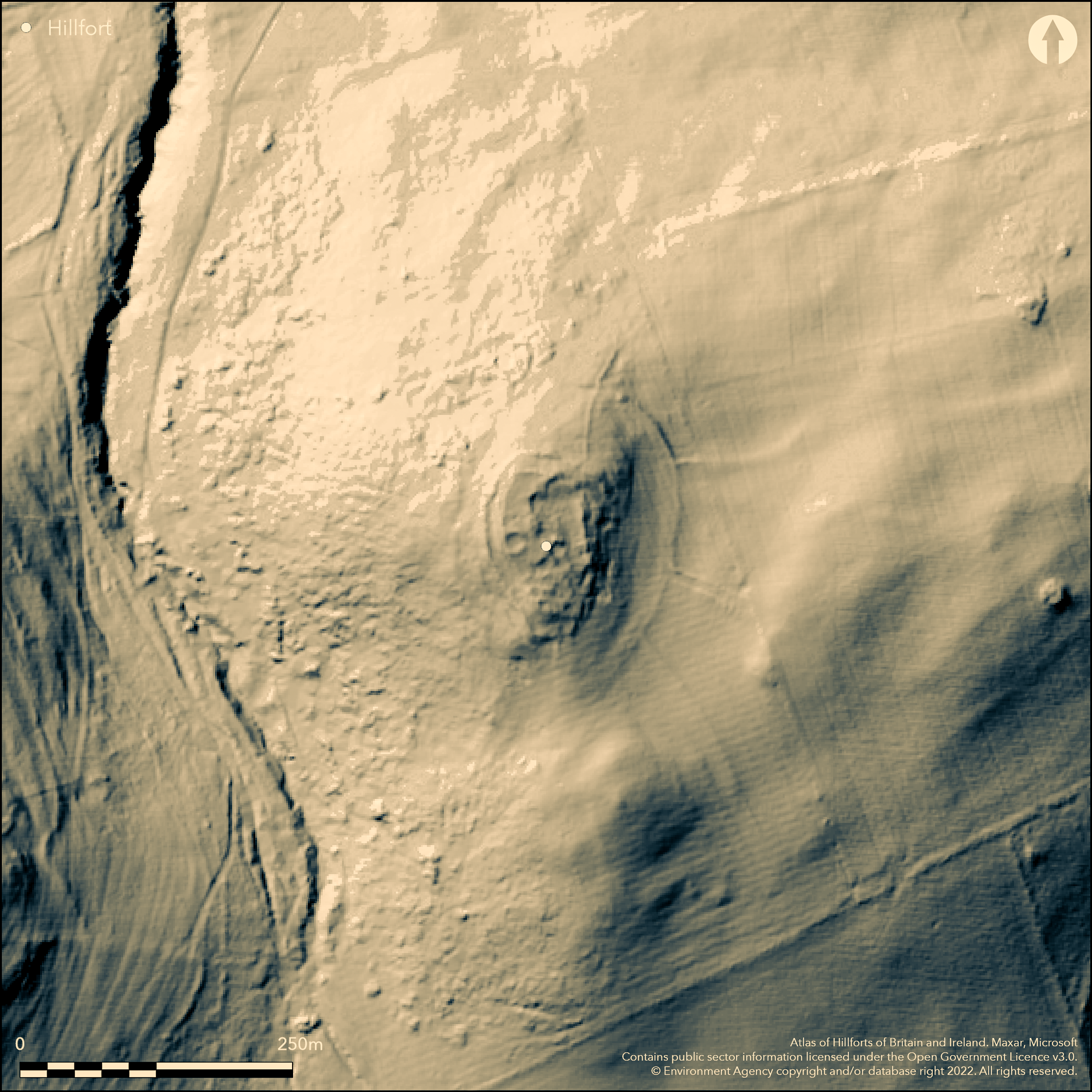
LiDAR 1m DTM Hillshade

Satellite Imagery
LiDAR 1m DTM Hillshade
Satellite Imagery
Scroll left/right to view further images.
HER: Northumberland 1429 (None)
NMR: NT 92 NW 43 (3028)
SM: 1006535
NGR: NT 9160 2979
X: 391610 Y: 629790 (OSGB36)
Lying 300m to the S of Kirknewton on the summit of St Gregory's Hill, a bivallate hillfort with overlying Romano-British settlement. The hillfort is sub-oval in plan enclosing approximately 0.2ha within the inner rampart and 0.4ha within the outer rampart. It lies on the summit of a small hill which drops away steeply in the N and W but with dead ground in the S and E and overlooked in the SW by West Hill (Atlas No. 0573) and in the SE by Yeavering Bell (Atlas No. 0568). The ramparts are of stone construction but stone robbing has reduced them to negative features in places. A survey by English Heritage in 2002 concluded that the inner rampart was a later feature. The inner rampart measures 5m wide and up to 0.4m high internally and 1.4m externally, now turfed covered with external facing stones exposed in the SE and NW. The outer rampart measures 6m wide, and 0.5m high internally and 1.8m externally. No evidence of ditches. An entrance in the NE probably dates to the Roman period associated with the enclosure in that area, the original probably lay in the S but was blocked in the Roman Iron Age and is now extensively robbed. Internally 12 stone-founded houses have been identified across two settlement areas, the boundaries of which lie across the ramparts. The most northerly of the settlements is probably later or longer lived (Oswald and McOmish 2002). A single large ring groove has also been recorded which is probably Iron Age in date. The foundations of medieval or later shepherds huts or pens lie in the S. Field systems within the environs of the hillfort are probably prehistoric. The site is shown on 1856-65 OS mapping. It is unexcavated but has undergone six large-scale analytical surveys beginning with MacLauchlan (1860). The most recent survey was carried our by English Heritage (ibid.) as part of the 'Discovering our Hillfort Heritage' Project.
Citizen Science: ✗
Reliability of Data: Confirmed
Reliability of Interpretation: Confirmed
X: -237620 Y: 7471663 (EPSG: 3857)
Longitude: -2.134572722231312 Latitude: 55.561752993214505 (EPSG:4326)
Country: England
Current County or Unitary Authority: Northumberland
Historic County: Northumberland
Current Parish/Community/Council/Townland: Kirknewton
In fair condition but badly robbed. Lies within the Northumberland National Park
| Extant | ✓ |
| Cropmark | ✗ |
| Likely Destroyed | ✗ |
None
| Woodland | ✗ |
| Commercial Forestry Plantation | ✗ |
| Parkland | ✗ |
| Pasture (Grazing) | ✓ |
| Arable | ✗ |
| Scrub/Bracken | ✗ |
| Bare Outcrop | ✗ |
| Heather/Moorland | ✗ |
| Heath | ✗ |
| Built-up | ✗ |
| Coastal Grassland | ✗ |
| Other | ✗ |
A contour fort lying on at 175m OD on the NW summit of St. Gregory's Hill
| Contour Fort | ✓ |
| Partial Contour Fort | ✗ |
| Promontory Fort | ✗ |
| Hillslope Fort | ✗ |
| Level Terrain Fort | ✗ |
| Marsh Fort | ✗ |
| Multiple Enclosure Fort | ✗ |
| Hilltop | ✓ |
| Coastal Promontory | ✗ |
| Inland Promontory | ✗ |
| Valley Bottom | ✗ |
| Knoll/Hillock/Outcrop | ✗ |
| Ridge | ✗ |
| Cliff/Plateau-edge/Scarp | ✗ |
| Hillslope | ✗ |
| Lowland | ✗ |
| Spur | ✗ |
Dominant Topographic Feature: NW summit of St. Gregory's Hill
| North | ✓ |
| Northeast | ✗ |
| East | ✗ |
| Southeast | ✗ |
| South | ✗ |
| Southwest | ✗ |
| West | ✗ |
| Northwest | ✓ |
| Level | ✗ |
Altitude: 175.0m
N/A
Undated, presumed Iron Age
Reliability: D - None
| Pre 1200BC | ✗ |
| 1200BC - 800BC | ✗ |
| 800BC - 400BC | ✗ |
| 400BC - AD50 | ✗ |
| AD50 - AD400 | ✗ |
| AD400 - AD 800 | ✗ |
| Post AD800 | ✗ |
| Unknown | ✓ |
| Pre Hillfort: | None |
| Post Hillfort: | Probable Roman settlement. An enclosure possibly a stock pen was appended to the E side of the hillfort after it fell into disuse. |
| Morphology/Earthwork/Typology: | None |
The site is shown on 1856-65 OS mapping. Surveyed by MacLauchlan 1860, Ordnance Survey (1860-1976), English Heritage survey 2002 (Oswald 2008, 3). Field investigations 1955 and 1976. Scheduled
| Other (1335): | Scheduled |
| 1st Identified Written Reference (1860): | Surveyed by MacLauchlan |
| Other (1955): | Field investigation |
| Other (1976): | Field investigation |
| Earthwork Survey (2002): | 'Discovering our Hillfort Heritage' Project |
| 1st Identified Map Depiction (None): | None |
Internally 12 stone-founded houses have been identified across two settlement areas, the boundaries of which lie across the ramparts. The most northerly of the settlements is probably later or longer lived (Oswald 2006). A single large ring groove has also been recorded, probably Iron Age in date. The foundations of medieval or later shepherds huts or pens lie in the S.
A small stream lies to the W of the hillfort
| None | ✓ |
| Spring | ✗ |
| Stream | ✗ |
| Pool | ✗ |
| Flush | ✗ |
| Well | ✗ |
| Other | ✗ |
Ring-groove house
| No Known Features | ✗ |
| Round Stone Structures | ✓ |
| Rectangular Stone Structures | ✗ |
| Curvilinear Platforms | ✗ |
| Other Roundhouse Evidence | ✗ |
| Pits | ✗ |
| Quarry Hollows | ✗ |
| Other | ✓ |
None
| No Known Excavation | ✓ |
| Pits | ✗ |
| Postholes | ✗ |
| Roundhouses | ✗ |
| Rectangular Structures | ✗ |
| Roads/Tracks | ✗ |
| Quarry Hollows | ✗ |
| Other | ✗ |
| Nothing Found | ✗ |
None
| No Known Geophysics | ✓ |
| Pits | ✗ |
| Roundhouses | ✗ |
| Rectangular Structures | ✗ |
| Roads/Tracks | ✗ |
| Quarry Hollows | ✗ |
| Other | ✗ |
| Nothing Found | ✗ |
None
| No Known Finds | ✓ |
| Pottery | ✗ |
| Metal | ✗ |
| Metalworking | ✗ |
| Human Bones | ✗ |
| Animal Bones | ✗ |
| Lithics | ✗ |
| Environmental | ✗ |
| Other | ✗ |
None
| APs Not Checked | ✓ |
| None | ✗ |
| Roundhouses | ✗ |
| Rectangular Structures | ✗ |
| Pits | ✗ |
| Postholes | ✗ |
| Roads/Tracks | ✗ |
| Other | ✗ |
The original entrance probably lay in the S but was blocked in the Roman Iron Age and is now extensively robbed. An entrance in the NE probably dates to the Roman period associated with the enclosure in that area.
| 2: | None |
| 2: | None |
Guard Chambers: ✗
Chevaux de Frise: ✗
| 1. Simple Gap (South): | None |
Bivallate with overlying Romano-British settlement. Sub-oval in plan enclosing approximately 0.2ha within the inner rampart and 0.4ha within the outer rampart. The ramparts are of stone construction but stone robbing has reduced them to negative features in places. The inner rampart is possibly later. The inner rampart measures 5m wide and up to 0.4m high internally and 1.4m externally, now turfed covered with external facing stones exposed in the SE and NW. The outer rampart measures 6m wide, and 0.5m high internally and 1.8m externally. No evidence of ditches.
| Area 1: | 0.2ha. |
| Area 2: | 0.4ha. |
| Total: | 0.4ha. |
Total Footprint Area: 0.4ha.
None
| ✓ | None |
| ✗ | None |
| NE Quadrant: | 2 |
| SE Quadrant: | 2 |
| SW Quadrant: | 2 |
| NW Quadrant: | 2 |
| Total: | 2 |
| Partial Univallate | ✗ |
| Univallate | ✗ |
| Partial Bivallate | ✗ |
| Bivallate | ✓ |
| Partial Multivallate | ✗ |
| Multivallate | ✗ |
| Unknown | ✗ |
| Partial Univallate | ✗ |
| Univallate | ✓ |
| Partial Bivallate | ✗ |
| Bivallate | ✗ |
| Partial Multivallate | ✗ |
| Multivallate | ✗ |
None
| None | ✗ |
| Earthen Bank | ✓ |
| Stone Wall | ✓ |
| Rubble | ✓ |
| Wall-walk | ✗ |
| Evidence of Timber | ✗ |
| Vitrification | ✗ |
| Other Burning | ✗ |
| Palisade | ✗ |
| Counter Scarp Bank | ✗ |
| Berm | ✗ |
| Unfinished | ✗ |
| Other | ✗ |
None
| None | ✗ |
| Earthen Bank | ✗ |
| Stone Wall | ✗ |
| Murus Duplex | ✗ |
| Timber-framed | ✗ |
| Timber-laced | ✗ |
| Vitrification | ✗ |
| Other Burning | ✗ |
| Palisade | ✗ |
| Counter Scarp Bank | ✗ |
| Berm | ✗ |
| Unfinished | ✗ |
| No Known Excavation | ✓ |
| Other | ✗ |
| ✗ | None |
| ✗ | None |
Number of Ditches: None
| ✗ | None |
Jobey, G.1965. Hillforts and Settlements in Northumberland. Archaeol Aeliana (4th Series) 43
MacLauchlan, H. 1919-22. Notes on camps in the parishes of Branxton, Carham, Ford, Kirknewton and Wooler in Northumberland. Hist Berwickshire Natur Club, 470
Oswald, A. Ainsworth, S. and Pearson, T 2006 Hillforts: Prehistoric Strongholds of Northumberland National Park. English Heritage
Oswald, A, Ainsworth, A and Pearson, T, 2008. Iron Age hillforts in their landscape contexts: a fresh look at the field evidence in the Northumberland cheviots', Archaeol Aeliana 5th series 37, 1-45
Oswald, A. and McOmish, D. 2002. Hillforts in the Northumberland National Park project: St Gregory's Hill Survey. English Heritage Report No: AI/1/2002. Unpublished
Atlas of Hillforts:
Wikidata:
This work is licensed under CC BY-SA 4.0![]()
![]()
![]() and should be cited as:
and should be cited as:
Lock, Gary and Ralston, Ian. 2024. Atlas of Hillforts of Britain and Ireland. Available at: https://hillforts.arch.ox.ac.uk
Document Version 1.1