LiDAR 1m DTM Hillshade
Satellite Imagery
LiDAR 1m DTM Hillshade
Satellite Imagery
Scroll left/right to view further images.
HER: Northumberland 1417 (None)
NMR: NT 92 NW 31 NT92NW 112 NT92NW 113 NT92NW 114 (2950)
SM: 1006534
NGR: NT 9097 2950
X: 390970 Y: 629500 (OSGB36)
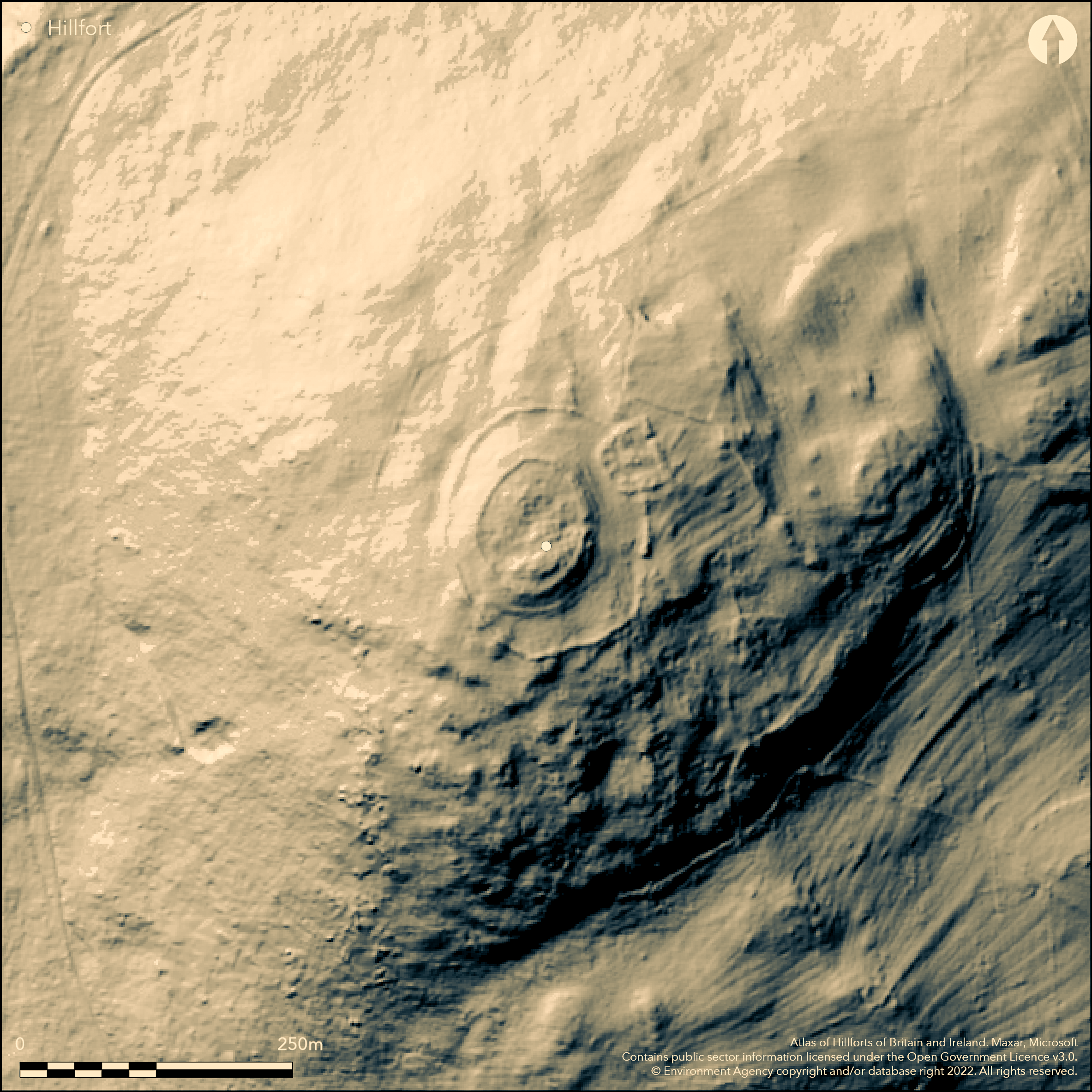
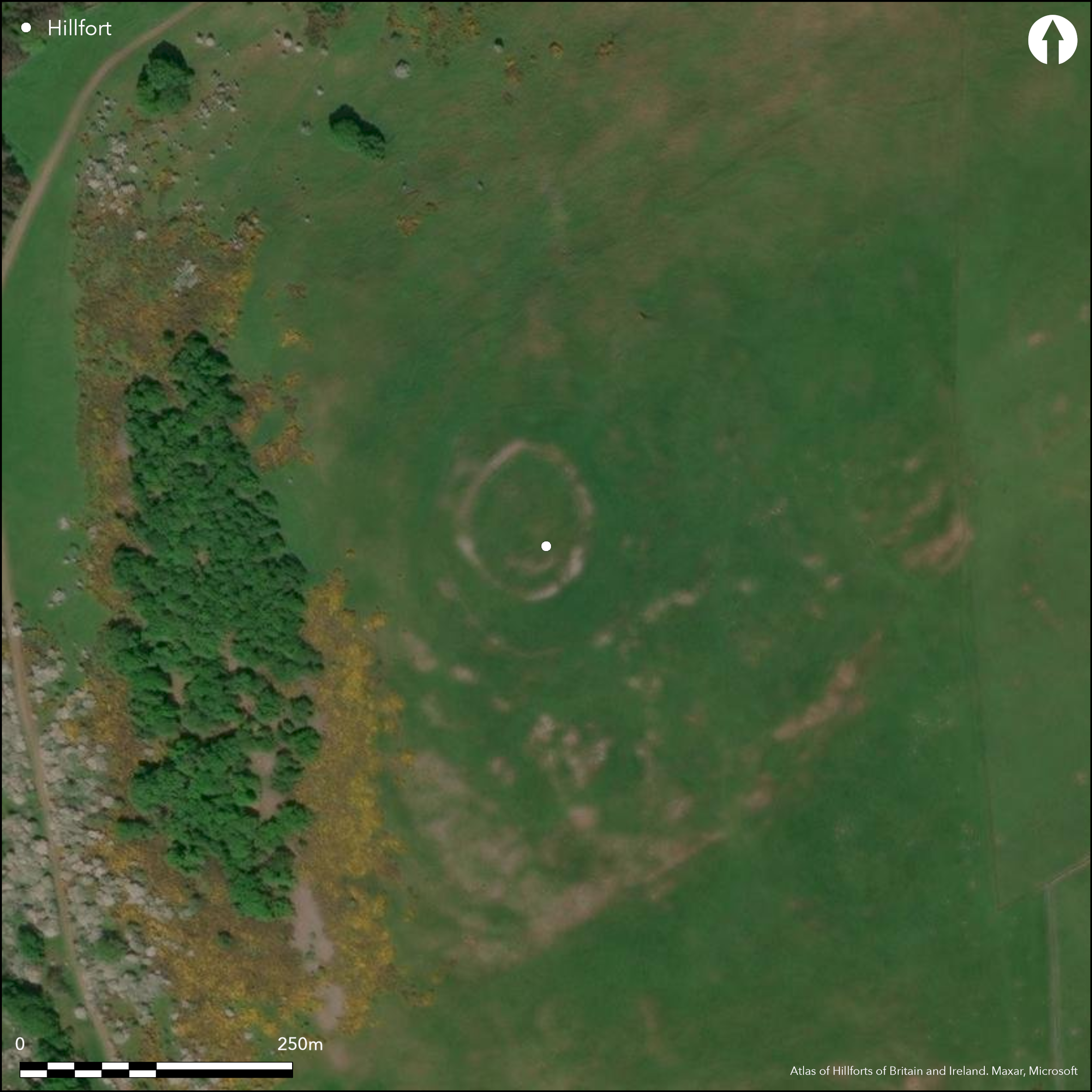
Lying 720m to the SW of Kirknewton, an Iron Age hillfort on the summit of West Hill. Sub oval in plan it was originally thought to be bivallate but the outer rampart is now considered to have been constructed in the Roman period from collapsed material from the inner rampart (Oswald 2004). It lies at 720m OD with steep natural slopes in the W and N offering views along the College Valley. The hillfort proper as defined by the inner enclosure measures 70m N-S by 60m E-W with an earth an stone rampart which encloses approximately 0.3ha. This rampart is approximately 3m wide increasing to 4.5m towards the entrance, which is a simple gap in the E. This circuit closely follows the contour of the hill around a small knoll, no evidence of a ditch. Earlier survey suggests a possible sub-circular banked and ditched enclosure underlies the hillfort (NT92NW 112), surviving as a ditch up to 1.8m wide and 0.3m deep with a slight internal bank interpreted as a palisade trench (Jobey 1964). The outer, much larger rampart runs down the N-facing slope and measures 130m N-S by 105m E-W with a rampart varying from 1.8m to 2.9m wide increasing to approximately 4.6m at the entrance which is also in the E. The earth and stone bank is revetted with large boulders set on edge. Three stone-founded hut circles and a rectilinear structure overlie the collapsed inner rampart (NT92NW 113) and are probably contemporary with the construction of the outer rampart. An Iron Age or Roman-British D-shaped enclosure (NT92NW 114) is superimposed across the circuit of the outer rampart in the NE. Four circular stone-founded buildings and two rectangular buildings have been recorded within the interior. The site is shown on 1856-65 OS mapping and was surveyed and drawn by Downman in 1909. No excavation, undated.
Citizen Science: ✗
Reliability of Data: Confirmed
Reliability of Interpretation: Confirmed
X: -238748 Y: 7471148 (EPSG: 3857)
Longitude: -2.1447102012294295 Latitude: 55.55913564302696 (EPSG:4326)
Country: England
Current County or Unitary Authority: Northumberland
Historic County: Northumberland
Current Parish/Community/Council/Townland: Kirknewton
Lies within the Northumberland National Park
| Extant | ✓ |
| Cropmark | ✗ |
| Likely Destroyed | ✗ |
None
| Woodland | ✗ |
| Commercial Forestry Plantation | ✗ |
| Parkland | ✗ |
| Pasture (Grazing) | ✓ |
| Arable | ✗ |
| Scrub/Bracken | ✗ |
| Bare Outcrop | ✗ |
| Heather/Moorland | ✗ |
| Heath | ✗ |
| Built-up | ✗ |
| Coastal Grassland | ✗ |
| Other | ✗ |
A contour fort lying at 202m OD encircling a knoll on the summit of West Hill
| Contour Fort | ✓ |
| Partial Contour Fort | ✗ |
| Promontory Fort | ✗ |
| Hillslope Fort | ✗ |
| Level Terrain Fort | ✗ |
| Marsh Fort | ✗ |
| Multiple Enclosure Fort | ✗ |
| Hilltop | ✗ |
| Coastal Promontory | ✗ |
| Inland Promontory | ✗ |
| Valley Bottom | ✗ |
| Knoll/Hillock/Outcrop | ✓ |
| Ridge | ✗ |
| Cliff/Plateau-edge/Scarp | ✗ |
| Hillslope | ✗ |
| Lowland | ✗ |
| Spur | ✗ |
Dominant Topographic Feature: Knoll on the summit of West Hill
| North | ✗ |
| Northeast | ✗ |
| East | ✗ |
| Southeast | ✗ |
| South | ✗ |
| Southwest | ✗ |
| West | ✓ |
| Northwest | ✗ |
| Level | ✗ |
Altitude: 202.0m
N/A
Undated presumed Iron Age. Possible earlier palisaded enclosure. Romano-British settlement.
Reliability: D - None
| Pre 1200BC | ✗ |
| 1200BC - 800BC | ✗ |
| 800BC - 400BC | ✗ |
| 400BC - AD50 | ✗ |
| AD50 - AD400 | ✗ |
| AD400 - AD 800 | ✗ |
| Post AD800 | ✗ |
| Unknown | ✓ |
| Pre Hillfort: | Possible palisade or ditched enclosure |
| Post Hillfort: | Romano-British settlement, Trig point |
| Morphology/Earthwork/Typology: | None |
Shown on 1856-65 OS mapping, the earthworks have been recorded by McLauchlan (1860), Downman 1909 and Jobey (c.1964). The site underwent a detailed analytical survey and reinterpretation in 1998 at the request of the Northumberland National Park Authority. Field investigation in 1955, 1969 and 1976. Scheduled
| 1st Identified Map Depiction (1856): | None |
| Earthwork Survey (1860): | McLauchlan |
| Earthwork Survey (1909): | E.A. Downman |
| Other (1935): | Scheduled |
| Other (1955): | Field investigation |
| Earthwork Survey (1964): | Jobey |
| Other (1969): | Field investigation |
| Other (1976): | Field investigation |
| Earthwork Survey (1998): | Analytical Survey 'Discovering our Hillfort Heritage' Project |
Three stone-founded hut circles and a rectilinear structure overlie the collapsed inner rampart (NT92NW 113) and are probably contemporary with the construction of the outer rampart.
College Burn to the W
| None | ✓ |
| Spring | ✗ |
| Stream | ✗ |
| Pool | ✗ |
| Flush | ✗ |
| Well | ✗ |
| Other | ✗ |
None
| No Known Features | ✗ |
| Round Stone Structures | ✓ |
| Rectangular Stone Structures | ✓ |
| Curvilinear Platforms | ✗ |
| Other Roundhouse Evidence | ✗ |
| Pits | ✗ |
| Quarry Hollows | ✗ |
| Other | ✗ |
None
| No Known Excavation | ✓ |
| Pits | ✗ |
| Postholes | ✗ |
| Roundhouses | ✗ |
| Rectangular Structures | ✗ |
| Roads/Tracks | ✗ |
| Quarry Hollows | ✗ |
| Other | ✗ |
| Nothing Found | ✗ |
None
| No Known Geophysics | ✓ |
| Pits | ✗ |
| Roundhouses | ✗ |
| Rectangular Structures | ✗ |
| Roads/Tracks | ✗ |
| Quarry Hollows | ✗ |
| Other | ✗ |
| Nothing Found | ✗ |
None
| No Known Finds | ✓ |
| Pottery | ✗ |
| Metal | ✗ |
| Metalworking | ✗ |
| Human Bones | ✗ |
| Animal Bones | ✗ |
| Lithics | ✗ |
| Environmental | ✗ |
| Other | ✗ |
None
| APs Not Checked | ✓ |
| None | ✗ |
| Roundhouses | ✗ |
| Rectangular Structures | ✗ |
| Pits | ✗ |
| Postholes | ✗ |
| Roads/Tracks | ✗ |
| Other | ✗ |
Single entrance in the E, simple gap
| 1: | None |
| 2: | None |
Guard Chambers: ✗
Chevaux de Frise: ✗
| 1. Simple Gap (East): | None |
The hillfort proper as defined by the inner enclosure measures 70m N-S by 60m E-W with an earth an stone rampart which encloses approximately 0.3ha. This rampart is approximately 3m wide increasing to 4.5m towards the entrance, which is a simple gap in the E. No evidence of a ditch. The possibly later bank encloses an area of 0.74ha exclusive of the hillfort (Gates and Deegan 2009, 157)
| Area 1: | 0.3ha. |
| Area 2: | 0.74ha. |
| Total: | 0.74ha. |
Total Footprint Area: 1.17ha.
None
| ✓ | Appears bivallate but outer rampart now believed to be later |
| ✓ | None |
| NE Quadrant: | 1 |
| SE Quadrant: | 1 |
| SW Quadrant: | 1 |
| NW Quadrant: | 1 |
| Total: | 1 |
| Partial Univallate | ✗ |
| Univallate | ✓ |
| Partial Bivallate | ✗ |
| Bivallate | ✗ |
| Partial Multivallate | ✗ |
| Multivallate | ✗ |
| Unknown | ✗ |
| Partial Univallate | ✗ |
| Univallate | ✓ |
| Partial Bivallate | ✗ |
| Bivallate | ✓ |
| Partial Multivallate | ✗ |
| Multivallate | ✗ |
None
| None | ✗ |
| Earthen Bank | ✓ |
| Stone Wall | ✓ |
| Rubble | ✓ |
| Wall-walk | ✗ |
| Evidence of Timber | ✗ |
| Vitrification | ✗ |
| Other Burning | ✗ |
| Palisade | ✓ |
| Counter Scarp Bank | ✗ |
| Berm | ✗ |
| Unfinished | ✗ |
| Other | ✗ |
None
| None | ✗ |
| Earthen Bank | ✗ |
| Stone Wall | ✗ |
| Murus Duplex | ✗ |
| Timber-framed | ✗ |
| Timber-laced | ✗ |
| Vitrification | ✗ |
| Other Burning | ✗ |
| Palisade | ✗ |
| Counter Scarp Bank | ✗ |
| Berm | ✗ |
| Unfinished | ✗ |
| No Known Excavation | ✓ |
| Other | ✗ |
| ✗ | None |
| ✗ | None |
Number of Ditches: None
| ✗ | None |
Gates, T and Deegan, A. 2009. Monuments in the Landscape in Passmore, D.G. and Waddington, C. (eds). Managing Archaeological Landscapes in Northumberland. Till-Tweed Studies, Vol 1. Oxbow, 125-171.
Jobey, G., 1964. Enclosed stone built settlements in North Northumberland. Archaeologia Aeliana (4th Series) 42
MacLauchlan, H. 1919-22. Notes on camps in the parishes of Branxton, Carham, Ford, Kirknewton and Wooler in Northumberland. Hist Berwickshire Natur Club, 469.
Oswald, A. 2004 An Iron Age hillfort in an evolving landscape:: analytical field survey on West Hill, Kirknewton. English Heritage. Unpublished.
Oswald, A.Jecock, M. and Ainsworth, S., 2000. An Iron Age hillfort and its environs on West Hill, Northumberland. Survey Report (English Heritage). Unpublished report
Oswald, A. Ainsworth, S. and Pearson, T 2006 Hillforts: Prehistoric Strongholds of Northumberland National Park. English Heritage
Oswald, A, Ainsworth, A and Pearson, T, 2008. 'Iron Age hillforts in their landscape contexts: a fresh look at the field evidence in the Northumberland cheviots', Archaeologia Aeliana 5th series 37, 1-45
Atlas of Hillforts:
Wikidata:
This work is licensed under CC BY-SA 4.0![]()
![]()
![]() and should be cited as:
and should be cited as:
Lock, Gary and Ralston, Ian. 2024. Atlas of Hillforts of Britain and Ireland. Available at: https://hillforts.arch.ox.ac.uk
Document Version 1.1