LiDAR 1m DTM Hillshade
Satellite Imagery
LiDAR 1m DTM Hillshade
Satellite Imagery
Scroll left/right to view further images.
HER: Northumberland 3743 (None)
NMR: NU 03 NE 13 (6071)
SM: 1006479
NGR: NU 05168 38893
X: 405168 Y: 638893 (OSGB36)
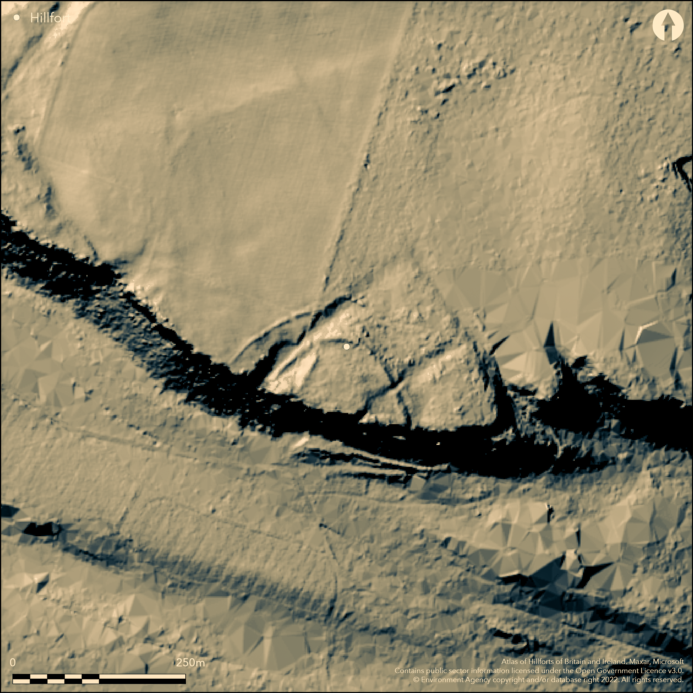
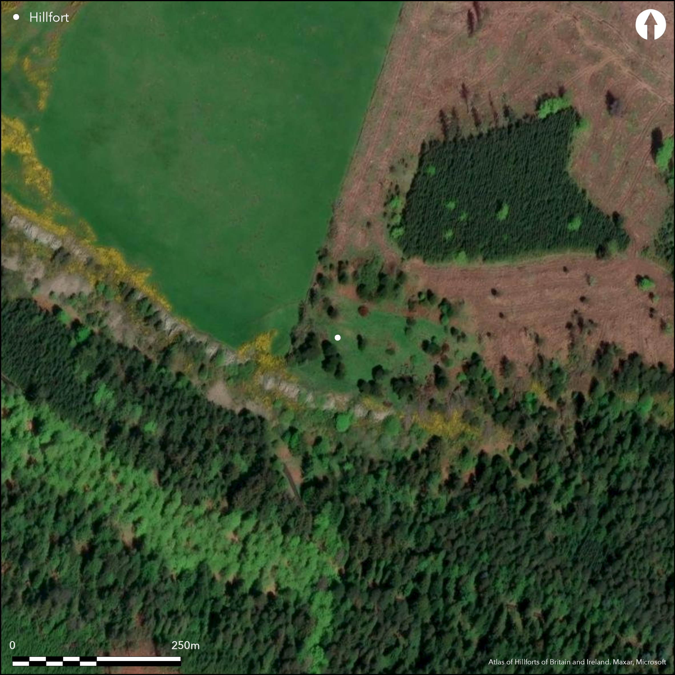
On steep crags at 152m OD overlooking Kyloe Woods, with views across to Lindisfarne, a cliff edge fort of 0.5ha. The site is enclosed by two concentric earth and stone ramparts in the N which curve to abut the edge of the steep rocky escarpment in the S and enclosing an area 109m E-W by 63m N-S. The ramparts are spaced approximately 25-30m apart with the inner rampart measuring 0.9-2m high and the outer rampart 0.6m. No evidence of ditches. Entrances lie in the NW and SE. One hut, visible as a scoop bounded by closely set orthostats has been identified within the interior. Tree planting has removed the evidence for further hut circles. A Neolithic axe head discovered in 1929 during quarrying was said to have fallen from the fort. On OS map (1856-65). Undated. Scheduled as Kyloe Hills promontory fort
Citizen Science: ✗
Reliability of Data: Confirmed
Reliability of Interpretation: Confirmed
X: -213672 Y: 7487790 (EPSG: 3857)
Longitude: -1.9194454239536431 Latitude: 55.643594957937545 (EPSG:4326)
Country: England; None
Current County or Unitary Authority: Northumberland
Historic County: Northumberland
Current Parish/Community/Council/Townland: Kyloe; Lowick
Some damage caused by afforestation but otherwise in good condition
| Extant | ✓ |
| Cropmark | ✗ |
| Likely Destroyed | ✗ |
None
| Woodland | ✓ |
| Commercial Forestry Plantation | ✗ |
| Parkland | ✗ |
| Pasture (Grazing) | ✗ |
| Arable | ✗ |
| Scrub/Bracken | ✓ |
| Bare Outcrop | ✗ |
| Heather/Moorland | ✗ |
| Heath | ✗ |
| Built-up | ✗ |
| Coastal Grassland | ✗ |
| Other | ✗ |
A cliff-edge fort lying on level ground at 152m OD with the terminals of the banks abutting a sheer scarp edge.
| Contour Fort | ✓ |
| Partial Contour Fort | ✗ |
| Promontory Fort | ✗ |
| Hillslope Fort | ✗ |
| Level Terrain Fort | ✓ |
| Marsh Fort | ✗ |
| Multiple Enclosure Fort | ✗ |
| Hilltop | ✗ |
| Coastal Promontory | ✗ |
| Inland Promontory | ✗ |
| Valley Bottom | ✗ |
| Knoll/Hillock/Outcrop | ✗ |
| Ridge | ✗ |
| Cliff/Plateau-edge/Scarp | ✓ |
| Hillslope | ✗ |
| Lowland | ✗ |
| Spur | ✗ |
Dominant Topographic Feature: Scarp edge
| North | ✗ |
| Northeast | ✓ |
| East | ✗ |
| Southeast | ✗ |
| South | ✗ |
| Southwest | ✗ |
| West | ✗ |
| Northwest | ✗ |
| Level | ✗ |
Altitude: 152.0m
Parish boundary between Kyloe and Lowick runs to the S
Boundary Type: Parish/Townland
Undated, presumed Iron Age
Reliability: D - None
| Pre 1200BC | ✗ |
| 1200BC - 800BC | ✗ |
| 800BC - 400BC | ✗ |
| 400BC - AD50 | ✗ |
| AD50 - AD400 | ✗ |
| AD400 - AD 800 | ✗ |
| Post AD800 | ✗ |
| Unknown | ✓ |
| Pre Hillfort: | A Neolithic axe head discovered in 1929 was said to have fallen from the fort and might indicate some earlier activity on the site |
| Post Hillfort: | None |
| Morphology/Earthwork/Typology: | None |
Shown on 1856-65 OS mapping. Surveyed by Jobey (1965). Field investigation in 1968; scheduled.
| Earthwork Survey (1965): | Jobey |
| Other (1968): | Field investigation |
| Other (1968): | Scheduled |
| 1st Identified Map Depiction (None): | None |
A probable hut has been identified from a scoop bounded by closely set orthostats. Tree planting has removed the evidence for further hut circles
A spring lies 500m to the N
| None | ✓ |
| Spring | ✗ |
| Stream | ✗ |
| Pool | ✗ |
| Flush | ✗ |
| Well | ✗ |
| Other | ✗ |
None
| No Known Features | ✗ |
| Round Stone Structures | ✓ |
| Rectangular Stone Structures | ✗ |
| Curvilinear Platforms | ✗ |
| Other Roundhouse Evidence | ✗ |
| Pits | ✗ |
| Quarry Hollows | ✗ |
| Other | ✗ |
None
| No Known Excavation | ✓ |
| Pits | ✗ |
| Postholes | ✗ |
| Roundhouses | ✗ |
| Rectangular Structures | ✗ |
| Roads/Tracks | ✗ |
| Quarry Hollows | ✗ |
| Other | ✗ |
| Nothing Found | ✗ |
None
| No Known Geophysics | ✓ |
| Pits | ✗ |
| Roundhouses | ✗ |
| Rectangular Structures | ✗ |
| Roads/Tracks | ✗ |
| Quarry Hollows | ✗ |
| Other | ✗ |
| Nothing Found | ✗ |
None
| No Known Finds | ✓ |
| Pottery | ✗ |
| Metal | ✗ |
| Metalworking | ✗ |
| Human Bones | ✗ |
| Animal Bones | ✗ |
| Lithics | ✗ |
| Environmental | ✗ |
| Other | ✗ |
None
| APs Not Checked | ✓ |
| None | ✗ |
| Roundhouses | ✗ |
| Rectangular Structures | ✗ |
| Pits | ✗ |
| Postholes | ✗ |
| Roads/Tracks | ✗ |
| Other | ✗ |
Entrances lie in the NW and SE, simple gaps
| 4: | None |
| 2: | None |
Guard Chambers: ✗
Chevaux de Frise: ✗
| 1. Simple Gap (North west): | Inner rampart |
| 1. Simple Gap (North west): | Outer rampart |
| 2. Simple Gap (South east): | Inner rampart |
| 2. Simple Gap (South east): | Outer rampart |
Two concentric earth and stone ramparts in the N which curve to abut the edge of the steep rocky escarpment in the S enclosing an area 109m E-W by 63m N-S. The ramparts are spaced approximately 25-30m apart with the inner rampart measuring 0.9-2m high and the outer rampart 0.6m. No evidence of ditches.
| Area 1: | 0.5ha. |
| Total: | 0.5ha. |
Total Footprint Area: Noneha.
None
| ✗ | None |
| ✗ | None |
| NE Quadrant: | 2 |
| SE Quadrant: | None |
| SW Quadrant: | None |
| NW Quadrant: | 2 |
| Total: | 2 |
| Partial Univallate | ✗ |
| Univallate | ✗ |
| Partial Bivallate | ✓ |
| Bivallate | ✗ |
| Partial Multivallate | ✗ |
| Multivallate | ✗ |
| Unknown | ✗ |
| Partial Univallate | ✗ |
| Univallate | ✗ |
| Partial Bivallate | ✗ |
| Bivallate | ✗ |
| Partial Multivallate | ✗ |
| Multivallate | ✗ |
None
| None | ✗ |
| Earthen Bank | ✓ |
| Stone Wall | ✗ |
| Rubble | ✓ |
| Wall-walk | ✗ |
| Evidence of Timber | ✗ |
| Vitrification | ✗ |
| Other Burning | ✗ |
| Palisade | ✗ |
| Counter Scarp Bank | ✗ |
| Berm | ✗ |
| Unfinished | ✗ |
| Other | ✗ |
None
| None | ✗ |
| Earthen Bank | ✗ |
| Stone Wall | ✗ |
| Murus Duplex | ✗ |
| Timber-framed | ✗ |
| Timber-laced | ✗ |
| Vitrification | ✗ |
| Other Burning | ✗ |
| Palisade | ✗ |
| Counter Scarp Bank | ✗ |
| Berm | ✗ |
| Unfinished | ✗ |
| No Known Excavation | ✓ |
| Other | ✗ |
| ✗ | None |
| ✗ | None |
Number of Ditches: None
| ✗ | None |
Hogg, A.H.A. 1979. British Hill-Forts. An Index. British Archaeological Reports, British Series 62. 125
Jobey, G.1965. Hillforts and Settlements in Northumberland. Archaeol Aeliana (4th Series) 43
Atlas of Hillforts:
Wikidata:
This work is licensed under CC BY-SA 4.0![]()
![]()
![]() and should be cited as:
and should be cited as:
Lock, Gary and Ralston, Ian. 2024. Atlas of Hillforts of Britain and Ireland. Available at: https://hillforts.arch.ox.ac.uk
Document Version 1.1