LiDAR 1m DTM Hillshade
Satellite Imagery
LiDAR 1m DTM Hillshade
Satellite Imagery
Scroll left/right to view further images.
HER: Northumberland 9740 (None)
NMR: NY 99 SW 11 (19700)
SM: 1007526
NGR: NY 9072 9383
X: 390720 Y: 593830 (OSGB36)
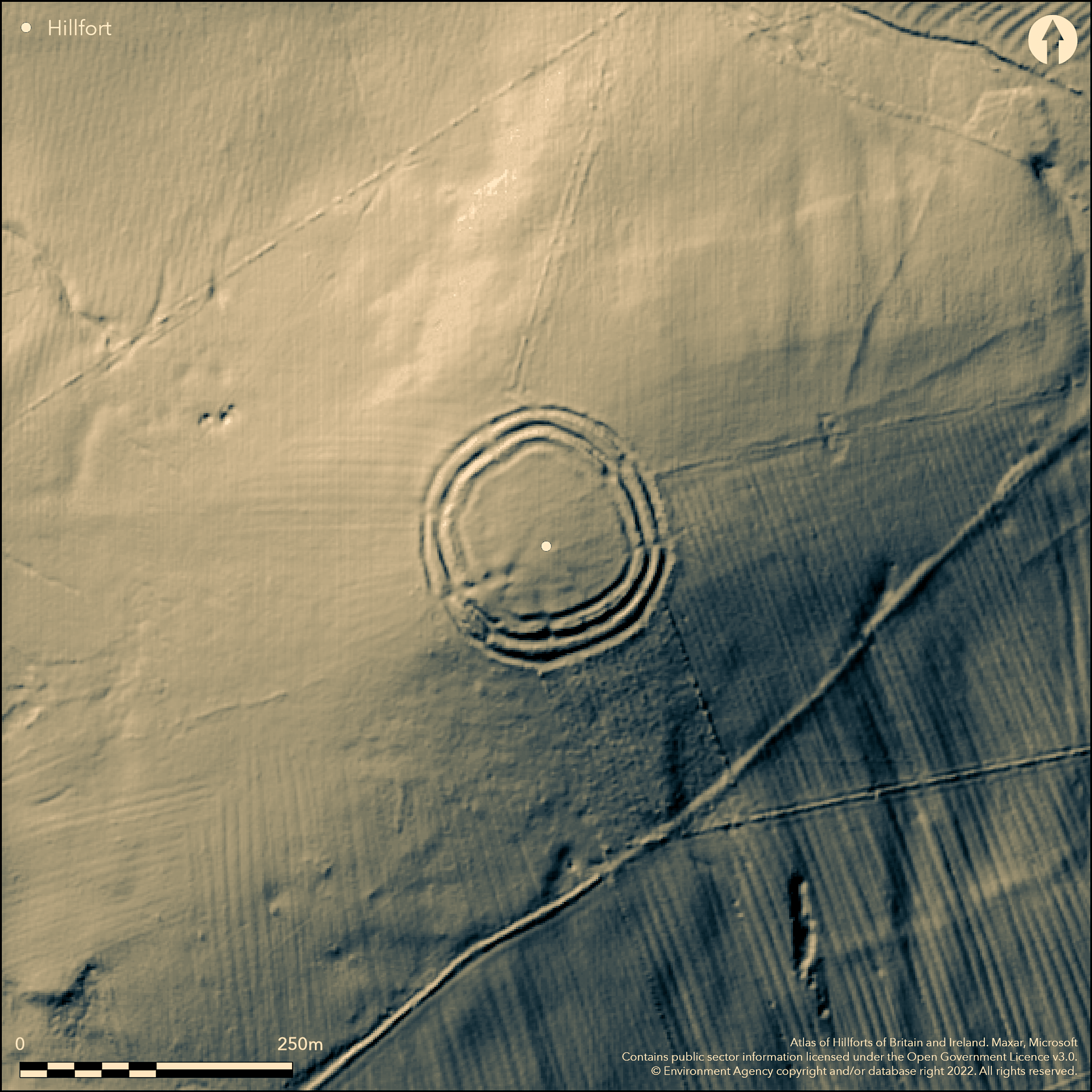
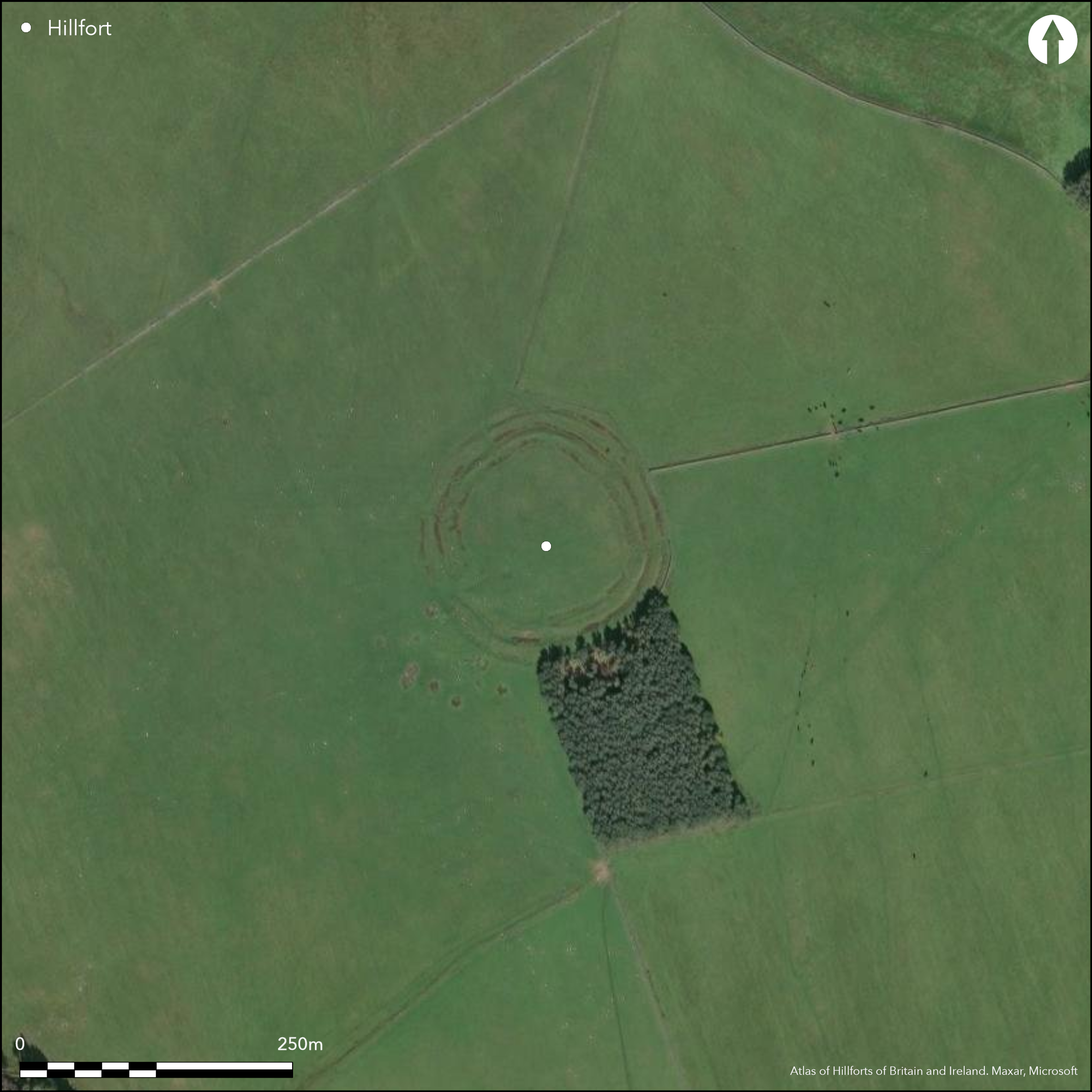
Lying 330m SW of Colwellhill at 261m OD, a multivallate hillfort on the summit of Camp Hill approximately 940m to the SE of Fawden Hill (Atlas No 0588). The hillfort is circular in plan measuring 83m in diameter and comprises three earth and stone banks and two medial ditches, enclosing 0.6ha. A further ditch lies internally which has probably resulted from scarping the inner rampart. The location offers extensive views in all directions, with steep slopes in all but the E. The inner bank measures 3-7m wide and 1m high, the middle bank 4-8m wide and 1m high and the outer bank 4m wide and averaging 2m high. The ditches measure 4-6m wide and 0.1-1m deep. Entrances lie in the NE and SW, 3m wide, with the one in the SW staggered and the inner rampart extending in the N to further defend the entrance. Four shallow scoops most probably represent the site of timber houses. The site is shown on 1856-65 OS mapping. No excavation has taken place and the site is undated. It survives in good condition. The site is scheduled as a defended settlement.
Citizen Science: ✗
Reliability of Data: Confirmed
Reliability of Interpretation: Confirmed
X: -239056 Y: 7408314 (EPSG: 3857)
Longitude: -2.1474755184062118 Latitude: 55.238610287184514 (EPSG:4326)
Country: England
Current County or Unitary Authority: Northumberland
Historic County: Northumberland
Current Parish/Community/Council/Townland: Otterburn
None
| Extant | ✓ |
| Cropmark | ✗ |
| Likely Destroyed | ✗ |
Some gorse on the ramparts
| Woodland | ✗ |
| Commercial Forestry Plantation | ✗ |
| Parkland | ✗ |
| Pasture (Grazing) | ✓ |
| Arable | ✗ |
| Scrub/Bracken | ✗ |
| Bare Outcrop | ✗ |
| Heather/Moorland | ✗ |
| Heath | ✗ |
| Built-up | ✗ |
| Coastal Grassland | ✗ |
| Other | ✗ |
A contour fort lying at 261m OD on level ground on the summit of Camp Hill.
| Contour Fort | ✓ |
| Partial Contour Fort | ✗ |
| Promontory Fort | ✗ |
| Hillslope Fort | ✗ |
| Level Terrain Fort | ✗ |
| Marsh Fort | ✗ |
| Multiple Enclosure Fort | ✗ |
| Hilltop | ✓ |
| Coastal Promontory | ✗ |
| Inland Promontory | ✗ |
| Valley Bottom | ✗ |
| Knoll/Hillock/Outcrop | ✗ |
| Ridge | ✗ |
| Cliff/Plateau-edge/Scarp | ✗ |
| Hillslope | ✗ |
| Lowland | ✗ |
| Spur | ✗ |
Dominant Topographic Feature: Summit of Camp Hill
| North | ✗ |
| Northeast | ✗ |
| East | ✗ |
| Southeast | ✓ |
| South | ✗ |
| Southwest | ✗ |
| West | ✗ |
| Northwest | ✓ |
| Level | ✗ |
Altitude: 261.0m
N/A
Undated, presumed Iron Age
Reliability: D - None
| Pre 1200BC | ✗ |
| 1200BC - 800BC | ✗ |
| 800BC - 400BC | ✗ |
| 400BC - AD50 | ✗ |
| AD50 - AD400 | ✗ |
| AD400 - AD 800 | ✗ |
| Post AD800 | ✗ |
| Unknown | ✓ |
| Pre Hillfort: | None |
| Post Hillfort: | None |
| Morphology/Earthwork/Typology: | None |
Reference in Hardy (1879), shown on 1856-65 OS mapping. It underwent field investigations in 1957 and 1970. Scheduled as a defended settlement
| 1st Identified Written Reference (1879): | None |
| Other (1957): | Field investigation |
| Other (1962): | Scheduled |
| Other (1970): | Field investigation |
| 1st Identified Map Depiction (None): | None |
Four shallow scoops most probably represent the site of timber houses.
Girsonfield Burn lies to the N and W
| None | ✓ |
| Spring | ✗ |
| Stream | ✗ |
| Pool | ✗ |
| Flush | ✗ |
| Well | ✗ |
| Other | ✗ |
Shallow scoops
| No Known Features | ✗ |
| Round Stone Structures | ✗ |
| Rectangular Stone Structures | ✗ |
| Curvilinear Platforms | ✗ |
| Other Roundhouse Evidence | ✓ |
| Pits | ✗ |
| Quarry Hollows | ✗ |
| Other | ✗ |
None
| No Known Excavation | ✓ |
| Pits | ✗ |
| Postholes | ✗ |
| Roundhouses | ✗ |
| Rectangular Structures | ✗ |
| Roads/Tracks | ✗ |
| Quarry Hollows | ✗ |
| Other | ✗ |
| Nothing Found | ✗ |
None
| No Known Geophysics | ✓ |
| Pits | ✗ |
| Roundhouses | ✗ |
| Rectangular Structures | ✗ |
| Roads/Tracks | ✗ |
| Quarry Hollows | ✗ |
| Other | ✗ |
| Nothing Found | ✗ |
None
| No Known Finds | ✓ |
| Pottery | ✗ |
| Metal | ✗ |
| Metalworking | ✗ |
| Human Bones | ✗ |
| Animal Bones | ✗ |
| Lithics | ✗ |
| Environmental | ✗ |
| Other | ✗ |
None
| APs Not Checked | ✓ |
| None | ✗ |
| Roundhouses | ✗ |
| Rectangular Structures | ✗ |
| Pits | ✗ |
| Postholes | ✗ |
| Roads/Tracks | ✗ |
| Other | ✗ |
Entrances lie in the NE and SW, 3m wide, with the one in the SW slightly staggered with an additional length of bank extending in the N to further defend the entrance
| 6: | Number of later breaks around the circuit |
| 2: | None |
Guard Chambers: ✗
Chevaux de Frise: ✗
| 1. Simple Gap (North east): | Inner rampart |
| 1. Simple Gap (North east): | Middle rampart |
| 1. Simple Gap (North east): | Outer rampart |
| 2. Oblique (South west): | Inner rampart. |
| 2. Oblique (South west): | Middle rampart |
| 2. Oblique (South west): | Outer rampart |
Circular in plan measuring 83m in diameter and comprising three earth and stone banks and two medial ditches. A further ditch lies internally which has probably resulted from scarping the inner rampart. The inner bank measures 3-7m wide and 1m high, the middle bank 4-8m wide and 1m high and the outer bank 4m wide and averaging 2m high. The ditches measure 4-6m wide and 0.1-1m deep.
| Area 1: | 0.6ha. |
| Total: | 0.6ha. |
Total Footprint Area: 1.4ha.
None
| ✗ | Areas estimated from satellite imagery |
| ✓ | None |
| NE Quadrant: | 3 |
| SE Quadrant: | 3 |
| SW Quadrant: | 3 |
| NW Quadrant: | 3 |
| Total: | 3 |
| Partial Univallate | ✗ |
| Univallate | ✗ |
| Partial Bivallate | ✗ |
| Bivallate | ✗ |
| Partial Multivallate | ✗ |
| Multivallate | ✓ |
| Unknown | ✗ |
| Partial Univallate | ✗ |
| Univallate | ✗ |
| Partial Bivallate | ✗ |
| Bivallate | ✗ |
| Partial Multivallate | ✗ |
| Multivallate | ✗ |
None
| None | ✗ |
| Earthen Bank | ✓ |
| Stone Wall | ✗ |
| Rubble | ✓ |
| Wall-walk | ✗ |
| Evidence of Timber | ✗ |
| Vitrification | ✗ |
| Other Burning | ✗ |
| Palisade | ✗ |
| Counter Scarp Bank | ✗ |
| Berm | ✗ |
| Unfinished | ✗ |
| Other | ✗ |
None
| None | ✗ |
| Earthen Bank | ✗ |
| Stone Wall | ✗ |
| Murus Duplex | ✗ |
| Timber-framed | ✗ |
| Timber-laced | ✗ |
| Vitrification | ✗ |
| Other Burning | ✗ |
| Palisade | ✗ |
| Counter Scarp Bank | ✗ |
| Berm | ✗ |
| Unfinished | ✗ |
| No Known Excavation | ✓ |
| Other | ✗ |
| ✗ | None |
| ✓ | None |
Number of Ditches: 3
| ✗ | None |
Hardy, J.1879-81. Hist Berwickshire Natur Club, 9, 461-2.
Hogg, A.H.A.1979. British Hill-Forts. An Index. British Archaeological Reports, British Series 62. 141
Atlas of Hillforts:
Wikidata:
This work is licensed under CC BY-SA 4.0![]()
![]()
![]() and should be cited as:
and should be cited as:
Lock, Gary and Ralston, Ian. 2024. Atlas of Hillforts of Britain and Ireland. Available at: https://hillforts.arch.ox.ac.uk
Document Version 1.1