LiDAR 1m DTM Hillshade
Satellite Imagery
LiDAR 1m DTM Hillshade
Satellite Imagery
Scroll left/right to view further images.
HER: Northumberland 2817 (None)
NMR: NU 00 SW 3 (4628)
SM: 1011267
NGR: NU 02346 00481
X: 402346 Y: 600481 (OSGB36)
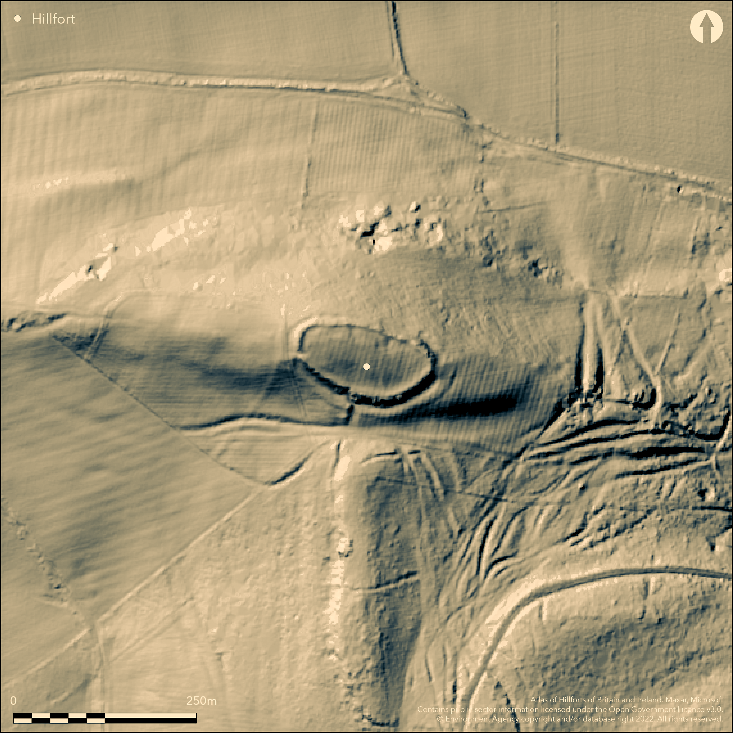
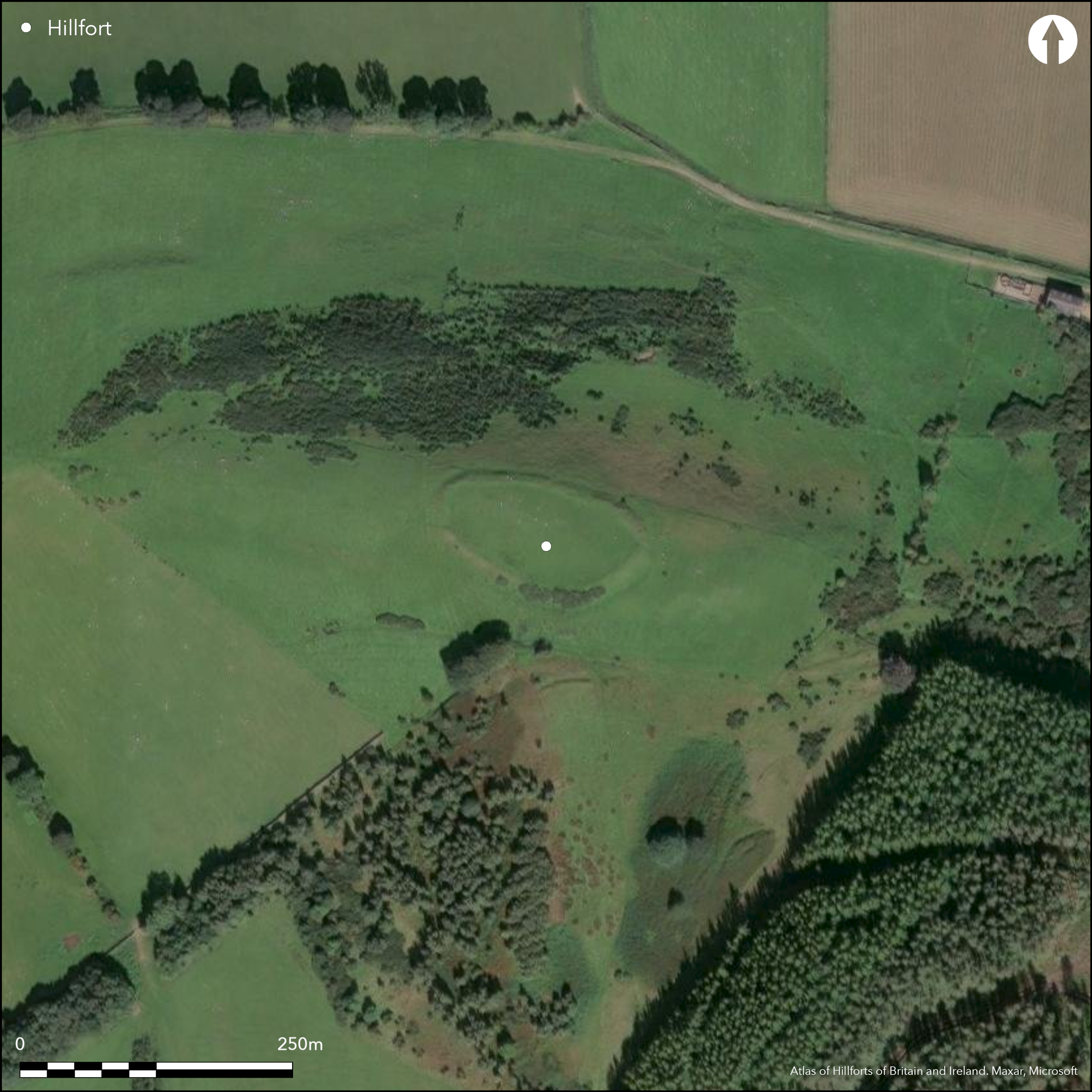
Lying 450m to the W of Great Tosson, an oval univallate hillfort of approximately 0.43ha. The site lies at 228m OD on the summit of a knoll at the N end of a promontory. The Coquet valley surrounds the promontory to the N, E and W. The enclosure measures 100m E-W by 45m N-S with a single rampart which was possibly formed by scarping the natural slopes from the inside, evidenced by the presence of a slight internal ditch. An external ditch up to 10m wide is visible on the S and SE sides where the rampart survives to a height of 2m above the bottom of the ditch. An entrance lies in the S where there is a break in the ditch and a staggered rampart with the SE terminal of the rampart curving slightly inwards. A holloway leads westwards from this entrance. A further 2.5m wide gap in the ramparts in the W and a causeway across the ditch and a lowering of the ramparts in the E might be further entrances. There is no visible evidence for internal occupation. Prehistoric finds are said to have been found on the hillside in the late 19th and early 20th centuries and a bronze axe was discovered within the enclosure by a workman in 1890, but no further information is available. Ploughing has occurred across the hillfort in the medieval or post medieval periods. The site is recorded on 1856-65 OS mapping and scheduled in 1932. It is undated but presumed iron Age.
Citizen Science: ✗
Reliability of Data: Confirmed
Reliability of Interpretation: Confirmed
X: -218697 Y: 7420008 (EPSG: 3857)
Longitude: -1.9645916850817604 Latitude: 55.298459754175894 (EPSG:4326)
Country: England
Current County or Unitary Authority: Northumberland
Historic County: Northumberland
Current Parish/Community/Council/Townland: Whitton and Tosson
None
| Extant | ✓ |
| Cropmark | ✗ |
| Likely Destroyed | ✗ |
Ploughed in the past
| Woodland | ✗ |
| Commercial Forestry Plantation | ✗ |
| Parkland | ✗ |
| Pasture (Grazing) | ✓ |
| Arable | ✗ |
| Scrub/Bracken | ✗ |
| Bare Outcrop | ✗ |
| Heather/Moorland | ✗ |
| Heath | ✗ |
| Built-up | ✗ |
| Coastal Grassland | ✗ |
| Other | ✗ |
A contour fort lying at 228m OD on the summit of a knoll on a northerly facing promontory
| Contour Fort | ✓ |
| Partial Contour Fort | ✗ |
| Promontory Fort | ✗ |
| Hillslope Fort | ✗ |
| Level Terrain Fort | ✗ |
| Marsh Fort | ✗ |
| Multiple Enclosure Fort | ✗ |
| Hilltop | ✗ |
| Coastal Promontory | ✗ |
| Inland Promontory | ✓ |
| Valley Bottom | ✗ |
| Knoll/Hillock/Outcrop | ✗ |
| Ridge | ✗ |
| Cliff/Plateau-edge/Scarp | ✗ |
| Hillslope | ✗ |
| Lowland | ✗ |
| Spur | ✗ |
Dominant Topographic Feature: Summit of a knoll
| North | ✓ |
| Northeast | ✗ |
| East | ✗ |
| Southeast | ✗ |
| South | ✗ |
| Southwest | ✗ |
| West | ✗ |
| Northwest | ✗ |
| Level | ✗ |
Altitude: 228.0m
N/A
Undated, presumed Iron Age
Reliability: D - None
| Pre 1200BC | ✗ |
| 1200BC - 800BC | ✓ |
| 800BC - 400BC | ✓ |
| 400BC - AD50 | ✓ |
| AD50 - AD400 | ✗ |
| AD400 - AD 800 | ✗ |
| Post AD800 | ✗ |
| Unknown | ✗ |
| Pre Hillfort: | None |
| Post Hillfort: | None |
Recorded on 1856-65 OS mapping. General reference in MacLauchlan (1867). Plan produced by Hedley (1892). Field investigations in 1957 and 1971. Scheduled
| 1st Identified Written Reference (1867): | None |
| Other (1892): | Plan (Hedley, 1892) |
| Other (1932): | Scheduled |
| Other (1957): | Field investigation |
| Other (1971): | Field investigation |
| 1st Identified Map Depiction (None): | None |
No internal features are known. Surface find of bronze axe. Interior cultivated in straight rigs
Wells and a small stream lie to the E of the hillfort
| None | ✓ |
| Spring | ✗ |
| Stream | ✗ |
| Pool | ✗ |
| Flush | ✗ |
| Well | ✗ |
| Other | ✗ |
None
| No Known Features | ✓ |
| Round Stone Structures | ✗ |
| Rectangular Stone Structures | ✗ |
| Curvilinear Platforms | ✗ |
| Other Roundhouse Evidence | ✗ |
| Pits | ✗ |
| Quarry Hollows | ✗ |
| Other | ✗ |
None
| No Known Excavation | ✓ |
| Pits | ✗ |
| Postholes | ✗ |
| Roundhouses | ✗ |
| Rectangular Structures | ✗ |
| Roads/Tracks | ✗ |
| Quarry Hollows | ✗ |
| Other | ✗ |
| Nothing Found | ✗ |
None
| No Known Geophysics | ✓ |
| Pits | ✗ |
| Roundhouses | ✗ |
| Rectangular Structures | ✗ |
| Roads/Tracks | ✗ |
| Quarry Hollows | ✗ |
| Other | ✗ |
| Nothing Found | ✗ |
Surface find of bronze axe
| No Known Finds | ✗ |
| Pottery | ✗ |
| Metal | ✓ |
| Metalworking | ✗ |
| Human Bones | ✗ |
| Animal Bones | ✗ |
| Lithics | ✗ |
| Environmental | ✗ |
| Other | ✗ |
None
| APs Not Checked | ✓ |
| None | ✗ |
| Roundhouses | ✗ |
| Rectangular Structures | ✗ |
| Pits | ✗ |
| Postholes | ✗ |
| Roads/Tracks | ✗ |
| Other | ✗ |
Entrance in the S where there is a break in the ditch and a staggered rampart with the SE terminal of the rampart curving slightly inwards. Further 2.5m wide gap in the ramparts in the W with a causeway across the ditch, and a lowering of the ramparts in the E might be further entrances.
| 3: | None |
| 2: | None |
Guard Chambers: ✗
Chevaux de Frise: ✗
| 1. In-turned (South): | SE terminal of the rampart curves slightly inwards |
| 1. Over-lapping (South): | None |
| 2. Other Forms (East): | Lowering of the ramparts only, but described in scheduling information as a possible entrance |
| 3. Simple Gap (West): | None |
Oval enclosure 100m E-W by 45m N-S with a single rampart which was possibly formed by scarping the natural slopes from the inside, evidenced by the presence of a slight internal ditch. An external ditch up to 10m wide is visible on the most vulnerable S and SE sides where the rampart survives to a height of 2m above the bottom of the ditch.
| Area 1: | 0.43ha. |
| Total: | 0.43ha. |
Total Footprint Area: Noneha.
None
| ✗ | None |
| ✓ | None |
| NE Quadrant: | 1 |
| SE Quadrant: | 1 |
| SW Quadrant: | 1 |
| NW Quadrant: | 1 |
| Total: | 1 |
| Partial Univallate | ✗ |
| Univallate | ✓ |
| Partial Bivallate | ✗ |
| Bivallate | ✗ |
| Partial Multivallate | ✗ |
| Multivallate | ✗ |
| Unknown | ✗ |
| Partial Univallate | ✗ |
| Univallate | ✗ |
| Partial Bivallate | ✗ |
| Bivallate | ✗ |
| Partial Multivallate | ✗ |
| Multivallate | ✗ |
None
| None | ✗ |
| Earthen Bank | ✓ |
| Stone Wall | ✗ |
| Rubble | ✗ |
| Wall-walk | ✗ |
| Evidence of Timber | ✗ |
| Vitrification | ✗ |
| Other Burning | ✗ |
| Palisade | ✗ |
| Counter Scarp Bank | ✗ |
| Berm | ✗ |
| Unfinished | ✗ |
| Other | ✗ |
None
| None | ✗ |
| Earthen Bank | ✗ |
| Stone Wall | ✗ |
| Murus Duplex | ✗ |
| Timber-framed | ✗ |
| Timber-laced | ✗ |
| Vitrification | ✗ |
| Other Burning | ✗ |
| Palisade | ✗ |
| Counter Scarp Bank | ✗ |
| Berm | ✗ |
| Unfinished | ✗ |
| No Known Excavation | ✓ |
| Other | ✗ |
| ✗ | None |
| ✓ | Slight internal ditch possibly created by scarping the rampart from the inside |
Number of Ditches: 2
| ✗ | None |
Hedley, R C. 1892. The Prehistoric Camps of Northumberland Archaeol Aeliana 2 ser 12 33-36
Hogg, A.H.A. 1947. A new list of the native sites of Northumberland. Proc Soc Antiq Newcastle (4th Series) 11, 167
Jobey, G.1965. Hillforts and Settlements in Northumberland. Archaeol Aeliana (4th Series) 43
MacLauchlan, H. 1867. Notes not included in the memoirs already published on Roman roads in Northumberland (Alnwick), 88
Atlas of Hillforts:
Wikidata:
This work is licensed under CC BY-SA 4.0![]()
![]()
![]() and should be cited as:
and should be cited as:
Lock, Gary and Ralston, Ian. 2024. Atlas of Hillforts of Britain and Ireland. Available at: https://hillforts.arch.ox.ac.uk
Document Version 1.1