LiDAR 1m DTM Hillshade
Satellite Imagery
LiDAR 1m DTM Hillshade
Satellite Imagery
Scroll left/right to view further images.
HER: Cornwall and Scilly MCO21 (2051)
NMR: SX 29 NW 6 (436509)
SM: 1010423
NGR: SX 2278 9746
X: 222800 Y: 97491 (OSGB36)
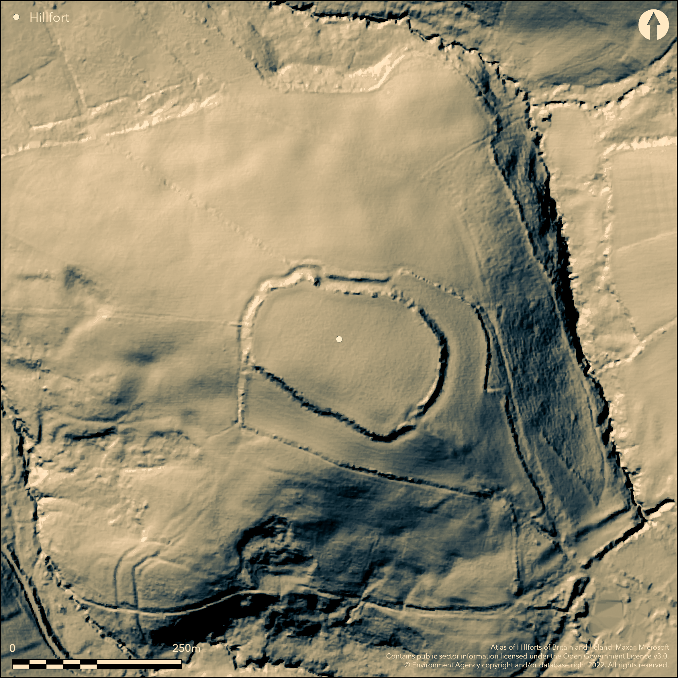
Univallate partial contour fort located on an isolated low hill with steep surrounding slopes except ridge on SE, and drops to upper tributaries of River Neet flowing towards Bude Bay 5km to the NW. Lies on Carboniferous Culm Measures, just beyond NW edge of low plateau between Rivers Ottery and Tamar, at junction with more deeply dissected coastal belt. Footprint c. 210m by 150m, with area c. 4.12ha, and featureless interior measures 182m WNW-ESE by 125m NNE-SSW, enclosing c. 2.27ha. Massive earth and rubble irregular rampart 8m wide and 3m high above outer ground level despite soil creep, with outer ditch to 10m wide and 1m deep, best preserved NW and SE ends. In NE and NW quadrants counterscarp bank to maximum 5m wide and 1.5m high. Entrance breaks occur in enclosure rampart and ditch circuit at NW end, c.5m wide, and SE end, c. 10m wide. Approach along ridge to SE crossed transversely by two, and possibly three, outworks similar to a promontory fort. One near to hillfort and centred 175m from SE entrance along the spur slope, comprises single rampart c. 8m wide, rising to maximum 1.5m high, running NE-SW in slight curve across the spur. Another outwork also includes a rampart on same axis, but centred 205m from the hillfort's SE entrance; this rampart is c. 8m wide and rises to maximum of 3m high. Broad outer ditch visible, c. 8m wide and 1.5m deep, extended at SW end by recent drainage cut. Both outworks cut by modern farm-track running NW from Ashbury Farm. Just outside entrance are faint indications of possible third outwork. Good preservation and prominent position resulted in mention and description in antiquarian records since early 19th century. Trees on ramparts, pasture interior, general good condition. On 1st Ed. OS map (1884). Undated.
Citizen Science: ✗
Reliability of Data: Confirmed
Reliability of Interpretation: Confirmed
X: -502424 Y: 6577163 (EPSG: 3857)
Longitude: -4.513352617943887 Latitude: 50.74984543779416 (EPSG:4326)
Country: England; None
Current County or Unitary Authority: Cornwall
Historic County: Cornwall
Current Parish/Community/Council/Townland: Week St Mary; Jacobstow
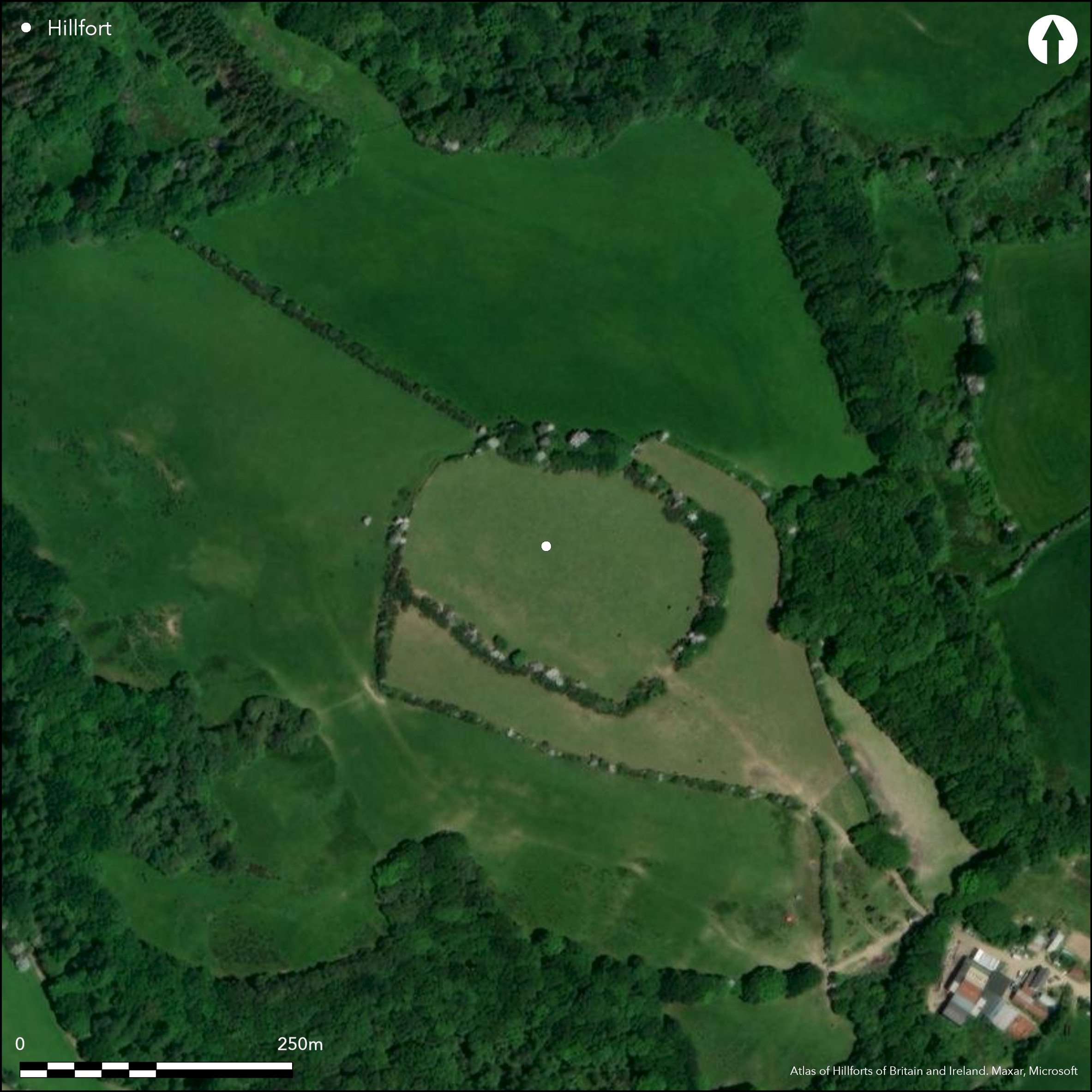
General good preservation, but SE entrance mutilated by quarrying. Both outworks cut by modern farm-track running NW from Ashbury Farm.
| Extant | ✓ |
| Cropmark | ✗ |
| Likely Destroyed | ✗ |
Trees on ramparts. Interior pasture. Farm track and quarrying.
| Woodland | ✓ |
| Commercial Forestry Plantation | ✗ |
| Parkland | ✗ |
| Pasture (Grazing) | ✓ |
| Arable | ✗ |
| Scrub/Bracken | ✗ |
| Bare Outcrop | ✗ |
| Heather/Moorland | ✗ |
| Heath | ✗ |
| Built-up | ✗ |
| Coastal Grassland | ✗ |
| Other | ✓ |
Univallate partial contour fort located on isolated low hill with steep surrounding slopes except ridge on SE and drops to upper tributaries of River Neet flowing towards Bude Bay 5km to NW.
| Contour Fort | ✗ |
| Partial Contour Fort | ✓ |
| Promontory Fort | ✗ |
| Hillslope Fort | ✗ |
| Level Terrain Fort | ✗ |
| Marsh Fort | ✗ |
| Multiple Enclosure Fort | ✗ |
| Hilltop | ✓ |
| Coastal Promontory | ✗ |
| Inland Promontory | ✗ |
| Valley Bottom | ✗ |
| Knoll/Hillock/Outcrop | ✗ |
| Ridge | ✗ |
| Cliff/Plateau-edge/Scarp | ✗ |
| Hillslope | ✗ |
| Lowland | ✗ |
| Spur | ✗ |
Dominant Topographic Feature: Low hill.
| North | ✗ |
| Northeast | ✗ |
| East | ✗ |
| Southeast | ✓ |
| South | ✗ |
| Southwest | ✗ |
| West | ✗ |
| Northwest | ✗ |
| Level | ✗ |
Altitude: 134.0m
Parish boundary 25m to W
Boundary Type: Parish/Townland
None
Reliability: D - None
| Pre 1200BC | ✗ |
| 1200BC - 800BC | ✗ |
| 800BC - 400BC | ✗ |
| 400BC - AD50 | ✗ |
| AD50 - AD400 | ✗ |
| AD400 - AD 800 | ✗ |
| Post AD800 | ✗ |
| Unknown | ✓ |
| Pre Hillfort: | None |
| Post Hillfort: | None |
On 1st Ed. OS map (1884). Mention and description in antiquarian records since early 19th century.
| 1st Identified Map Depiction (1884): | OS map |
| 1st Identified Written Reference (None): | Mention and description in antiquarian records since early 19th century. |
None
None
| None | ✓ |
| Spring | ✗ |
| Stream | ✗ |
| Pool | ✗ |
| Flush | ✗ |
| Well | ✗ |
| Other | ✗ |
None
| No Known Features | ✓ |
| Round Stone Structures | ✗ |
| Rectangular Stone Structures | ✗ |
| Curvilinear Platforms | ✗ |
| Other Roundhouse Evidence | ✗ |
| Pits | ✗ |
| Quarry Hollows | ✗ |
| Other | ✗ |
None
| No Known Excavation | ✓ |
| Pits | ✗ |
| Postholes | ✗ |
| Roundhouses | ✗ |
| Rectangular Structures | ✗ |
| Roads/Tracks | ✗ |
| Quarry Hollows | ✗ |
| Other | ✗ |
| Nothing Found | ✗ |
None
| No Known Geophysics | ✓ |
| Pits | ✗ |
| Roundhouses | ✗ |
| Rectangular Structures | ✗ |
| Roads/Tracks | ✗ |
| Quarry Hollows | ✗ |
| Other | ✗ |
| Nothing Found | ✗ |
None
| No Known Finds | ✓ |
| Pottery | ✗ |
| Metal | ✗ |
| Metalworking | ✗ |
| Human Bones | ✗ |
| Animal Bones | ✗ |
| Lithics | ✗ |
| Environmental | ✗ |
| Other | ✗ |
None
| APs Not Checked | ✓ |
| None | ✗ |
| Roundhouses | ✗ |
| Rectangular Structures | ✗ |
| Pits | ✗ |
| Postholes | ✗ |
| Roads/Tracks | ✗ |
| Other | ✗ |
Entrance breaks occur in enclosure rampart and ditch circuit at NW end, c. 5m wide, and SE end, c.10m wide, where out-turned.
| 4: | None |
| 2: | NW and SE possible original entrances. |
Guard Chambers: ✗
Chevaux de Frise: ✗
| 1. Out-turned (South east): | None |
| 2. Simple Gap (North west): | None |
Massive earth and rubble irregular rampart 8m wide and 3m high above outer ground level despite soil creep, with outer ditch to 10m wide and to 1m deep, best preserved around NW and SE ends. In NE and NW quadrants counterscarp bank survives to maximum 5m wide and 1.5m high. Entrance breaks occur in enclosure rampart and ditch circuit at the NW end, c. 5m wide, and SE end, c. 10m wide. Approach along ridge to SE crossed transversely by two, and possibly three, outworks similar to a cliff castle. One near to hillfort and centred 175m from SE entrance along the spur slope, comprises single rampart c. 8m wide, rising to maximum 1.5m high, running NE-SW in slight curve across the spur. Another outwork also includes a rampart on the same axis, but centred 205m from the hillfort's SE entrance; this rampart is c. 8m wide and rises to maximum of 3m high. Broad outer ditch visible, c. 8m wide and 1.5m deep, extended at SW end by recent drainage cut. Both outworks cut by modern farm-track running NW from Ashbury Farm.
| Area 1: | 2.27ha. |
| Total: | 2.27ha. |
Total Footprint Area: 4.12ha.
None
| ✗ | None |
| ✓ | None |
| NE Quadrant: | 1 |
| SE Quadrant: | 1 |
| SW Quadrant: | 1 |
| NW Quadrant: | 1 |
| Total: | 1 |
| Partial Univallate | ✗ |
| Univallate | ✓ |
| Partial Bivallate | ✗ |
| Bivallate | ✗ |
| Partial Multivallate | ✗ |
| Multivallate | ✗ |
| Unknown | ✗ |
| Partial Univallate | ✗ |
| Univallate | ✗ |
| Partial Bivallate | ✗ |
| Bivallate | ✗ |
| Partial Multivallate | ✗ |
| Multivallate | ✗ |
Massive earth and rubble rampart. In NE and NW quadrants counterscarp bank to maximum 5m wide and 1.5m high.
| None | ✗ |
| Earthen Bank | ✓ |
| Stone Wall | ✗ |
| Rubble | ✓ |
| Wall-walk | ✗ |
| Evidence of Timber | ✗ |
| Vitrification | ✗ |
| Other Burning | ✗ |
| Palisade | ✗ |
| Counter Scarp Bank | ✓ |
| Berm | ✗ |
| Unfinished | ✗ |
| Other | ✗ |
None
| None | ✗ |
| Earthen Bank | ✗ |
| Stone Wall | ✗ |
| Murus Duplex | ✗ |
| Timber-framed | ✗ |
| Timber-laced | ✗ |
| Vitrification | ✗ |
| Other Burning | ✗ |
| Palisade | ✗ |
| Counter Scarp Bank | ✗ |
| Berm | ✗ |
| Unfinished | ✗ |
| No Known Excavation | ✓ |
| Other | ✗ |
| ✗ | None |
| ✓ | None |
Number of Ditches: 1
| ✗ | None |
Henderson, C. 1925. East Cornwall Book, Unpublished manuscript at Royal Institution of Cornwall, 509.
Henderson, C. 1930. Parochial Antiquities of East Cornwall, Unpublished manuscript at Royal Institution of Cornwall, 590.
Lysons, D. and Lysons, S. 1814. Magna Britannia. Vol 3, Cornwall.
Polsue, J. ed. 1867-72, Lake's Parochial History of Cornwall.
Atlas of Hillforts:
Wikidata:
This work is licensed under CC BY-SA 4.0![]()
![]()
![]() and should be cited as:
and should be cited as:
Lock, Gary and Ralston, Ian. 2024. Atlas of Hillforts of Britain and Ireland. Available at: https://hillforts.arch.ox.ac.uk
Document Version 1.1