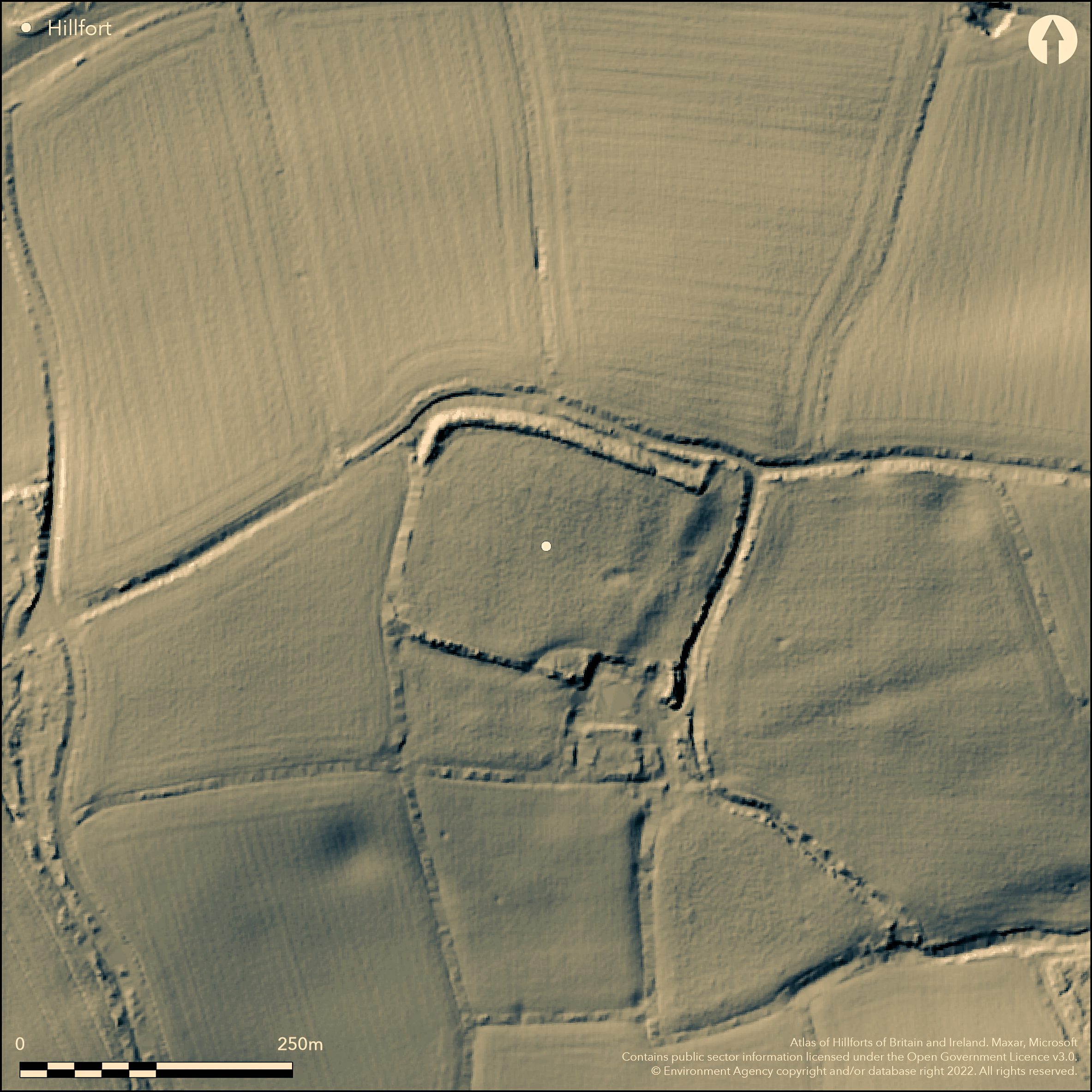
LiDAR 1m DTM Hillshade
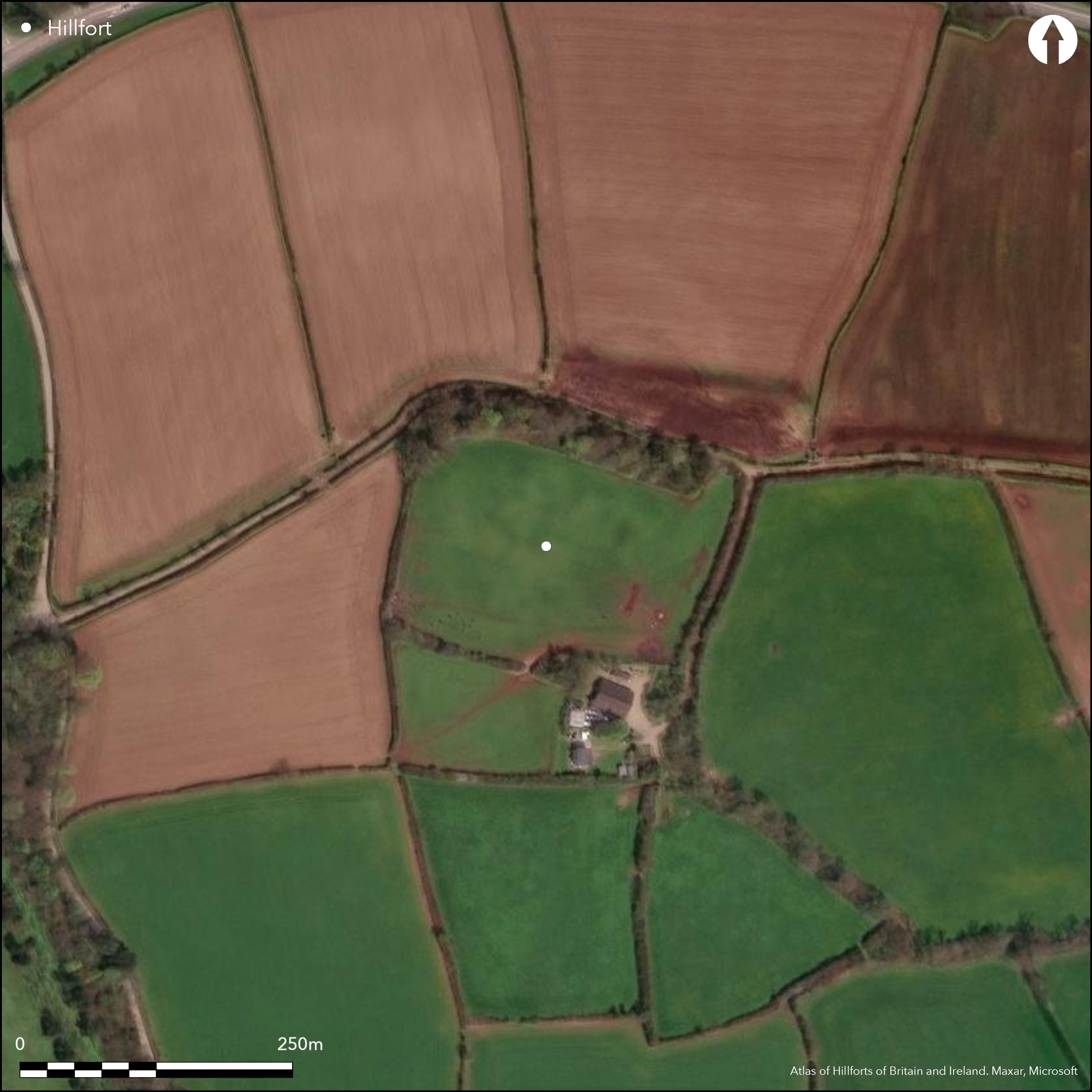
Satellite Imagery
LiDAR 1m DTM Hillshade
Satellite Imagery
Scroll left/right to view further images.
HER: Cornwall and Scilly MCO43 (23028)
NMR: SW 94 NW 2 (429711)
SM: 1016890
NGR: SW91884828
X: 191880 Y: 48280 (OSGB36)
Univallate, partial contour hillfort sited to E of spur crest on slight S-facing slope and on a ridgeway c. 2.5km W of River Fal, considered navigable in Roman period. Moderate slopes on all sides. Could still be traced as a rectangle with rounded corners in 1848. Sub-rectangular shape encloses 2ha. Rampart and ditch to N still substantial, former to 1.8m high and 10m wide, whilst those on W and S now modern field walls and hedgerows and on E a scarp reduced by cultivation. Remnants of rampart visible as thickenings of walls towards the middle of W wall and where S wall abuts the farmyard. S ditch now slight depression to S of the S wall. E rampart now gone to enlarge the field, but still can be seen as an irregular spread. Site has rounded corners, best on NW, but levelled on SE by farm buildings. Fronting ditch best on N where 8m wide and although filled-in still to 0.4m deep. Excavation shows this to have been 4.5m deep and already filled with silt material to 1.5m before any Roman pottery deposited. Ditch shows as slight depression elsewhere. Single E entrance where bank terminals curved and revetted in stone to form massive timber gateway with causeway over ditch. Later, in Romano-British period, this causeway overlain by well-made road out of site SE through Park Mears and S of Bartelever to River Fal (no traces now visible). Within site the road divided, forking to the NW and SW. Excavations in 1968-70 by Douch and Beard and earlier geophysics found a possibly pre-Roman circular building and pattern of sub-rectangular enclosures in interior. The earliest occupation of the hut dated to 1st century AD. During 2nd century building associated with metalworking before becoming the site of a midden. Finds from trench just inside E defences included coins, brooches, glass and pottery, all, apart from a few Iron Age sherds, 1st century to second half of 3rd century AD (most 60-130 AD). Excavations in the NW corner of the camp revealed postholes of a timber tower and stone revetting on the inside of the rampart, all, with above, suggesting Roman occupation of the site, possibly as a military fort. Irregular ridge also confirmed as remains of E rampart, with exterior ditch containing occupation levels and included iron slag associated with smithy. Inside rampart at NE corner inter-vallate road, postholes possibly representing stables and two hearths. Occupation beyond enclosure suggested by geophysics to include V-shaped ditch, to 1.2m deep, enclosures and pits opposite the E entrance. Possibly part of external vicus, native trading settlement or Roman-British village. On OS 1" map of 1813 and 1st Ed. OS 2500 map (1880).
Citizen Science: ✗
Reliability of Data: Confirmed
Reliability of Interpretation: Confirmed
X: -548097 Y: 6497976 (EPSG: 3857)
Longitude: -4.923641530285528 Latitude: 50.29760122027317 (EPSG:4326)
Country: England
Current County or Unitary Authority: Cornwall
Historic County: Cornwall
Current Parish/Community/Council/Townland: Probus
Much damaged and affected by farming operations and farm buildings.
| Extant | ✓ |
| Cropmark | ✗ |
| Likely Destroyed | ✓ |
Farmed.
| Woodland | ✗ |
| Commercial Forestry Plantation | ✗ |
| Parkland | ✗ |
| Pasture (Grazing) | ✓ |
| Arable | ✗ |
| Scrub/Bracken | ✗ |
| Bare Outcrop | ✗ |
| Heather/Moorland | ✗ |
| Heath | ✗ |
| Built-up | ✓ |
| Coastal Grassland | ✗ |
| Other | ✗ |
Univallate, partial contour hillfort sited to E of spur crest on slight S-facing slope and on a ridgeway c. 2.5km W of River Fal, considered navigable in Roman period. Moderate slopes on all sides.
| Contour Fort | ✗ |
| Partial Contour Fort | ✓ |
| Promontory Fort | ✗ |
| Hillslope Fort | ✗ |
| Level Terrain Fort | ✗ |
| Marsh Fort | ✗ |
| Multiple Enclosure Fort | ✗ |
Sited just to the east of a spur summit
| Hilltop | ✗ |
| Coastal Promontory | ✗ |
| Inland Promontory | ✗ |
| Valley Bottom | ✗ |
| Knoll/Hillock/Outcrop | ✗ |
| Ridge | ✗ |
| Cliff/Plateau-edge/Scarp | ✗ |
| Hillslope | ✗ |
| Lowland | ✗ |
| Spur | ✓ |
Dominant Topographic Feature: Spur
| North | ✗ |
| Northeast | ✗ |
| East | ✗ |
| Southeast | ✗ |
| South | ✓ |
| Southwest | ✗ |
| West | ✗ |
| Northwest | ✗ |
| Level | ✗ |
Altitude: 85.0m
N/A
Ceramic evidence indicates site occupied from Iron Age as South Western Decorated pottery was present.
Reliability: B - Medium
| Pre 1200BC | ✗ |
| 1200BC - 800BC | ✗ |
| 800BC - 400BC | ✗ |
| 400BC - AD50 | ✓ |
| AD50 - AD400 | ✓ |
| AD400 - AD 800 | ✗ |
| Post AD800 | ✗ |
| Unknown | ✗ |
| Pre Hillfort: | None |
| Post Hillfort: | None |
| Artefactual: | Predominantly pottery, coins, glass, pottery. |
Mention by W. Borlase 1754. On OS 1" map of 1813. On 1st Ed. OS map (1880). H. MacLauchlan saw site in 1848, and could still be traced as a rectangle with rounded corners. Geophysical Survey by Bartlett, A and David, A 1980. Excavation 1968-1970 by H.L Douch, H L and S.W.Beard. Field investigation Ordnance Survey 1977.
| 1st Identified Written Reference (1754): | W. Borlase. |
| 1st Identified Map Depiction (1813): | OS map |
| Other (1848): | Seen by H. MacLauchlan. |
| Other (1880): | OS 2500 map. |
| Other (1977): | Field investigation OS. |
| Geophysical Survey (1980): | A. Bartlett and A. David - no details. |
| Excavation (None): | H.L Douch, H L and S.W.Beard. |
Excavations in 1968-70 by Douch and Beard and earlier geophysics found a possibly pre-Roman circular building and pattern of sub-rectangular enclosures in interior. Finds from trench just inside E defences included coins, brooches, glass and pottery, all, apart from a few Iron Age sherds, 1st century to second half of 3rd century AD (most 60-130 AD). Iron slag associated with smithy. Excavations in the NW corner of the camp revealed post-holes of a timber tower.
None
| None | ✓ |
| Spring | ✗ |
| Stream | ✗ |
| Pool | ✗ |
| Flush | ✗ |
| Well | ✗ |
| Other | ✗ |
None
| No Known Features | ✓ |
| Round Stone Structures | ✗ |
| Rectangular Stone Structures | ✗ |
| Curvilinear Platforms | ✗ |
| Other Roundhouse Evidence | ✗ |
| Pits | ✗ |
| Quarry Hollows | ✗ |
| Other | ✗ |
Excavations in 1968-70 by Douch and Beard and earlier geophysics found a possibly pre-Roman circular building and pattern of sub-rectangular enclosures in interior. Excavations in the NW corner of the camp revealed post-holes of a timber tower.
| No Known Excavation | ✗ |
| Pits | ✗ |
| Postholes | ✓ |
| Roundhouses | ✓ |
| Rectangular Structures | ✗ |
| Roads/Tracks | ✗ |
| Quarry Hollows | ✗ |
| Other | ✓ |
| Nothing Found | ✗ |
Excavations in 1968-70 by Douch and Beard and earlier geophysics found a possibly pre-Roman circular building and pattern of sub-rectangular enclosures in interior.
| No Known Geophysics | ✗ |
| Pits | ✗ |
| Roundhouses | ✓ |
| Rectangular Structures | ✗ |
| Roads/Tracks | ✗ |
| Quarry Hollows | ✗ |
| Other | ✓ |
| Nothing Found | ✗ |
Finds from trench just inside E defences included coins, brooches, glass and pottery, all, apart from a few Iron Age sherds, 1st century to second half of 3rd century AD (most 60-130 AD). Iron slag associated with smithy. Thus, the ceramic evidence indicates site in occupation from Iron Age as South Western Decorated pottery was present. Samian and coin evidence indicate further occupation from the Neronian-Early Flavius period, as appropriate for a Roman military site.
| No Known Finds | ✗ |
| Pottery | ✓ |
| Metal | ✓ |
| Metalworking | ✓ |
| Human Bones | ✗ |
| Animal Bones | ✗ |
| Lithics | ✗ |
| Environmental | ✗ |
| Other | ✓ |
None
| APs Not Checked | ✓ |
| None | ✗ |
| Roundhouses | ✗ |
| Rectangular Structures | ✗ |
| Pits | ✗ |
| Postholes | ✗ |
| Roads/Tracks | ✗ |
| Other | ✗ |
Single E entrance where bank terminals curved and revetted in stone to form massive timber gateway with causeway over ditch. Later, in Romano-British period, this causeway overlain by well-made road which can be traced out of site SE through Park Mears and S of Bartelever to River Fal.
| 1: | None |
| 2: | None |
Guard Chambers: ✗
Chevaux de Frise: ✗
| 1. In-turned (East): | Causeway over ditch. |
Rampart and ditch to N still substantial, former to 1.8m high and 10m wide, whist those on W and S now modern field walls and hedgerows and on E a scarp reduced by cultivation. Remnants of rampart visible as thickenings of walls towards the middle of the W wall and where S wall abuts the farmyard. S ditch now slight depression to S of the S wall. E rampart now gone to enlarge the filed, but still can be seen as an irregular spread. Site has rounded corners, best on NW, but levelled on SE by farm buildings. The fronting ditch best on N where 8m wide and although filled in still to 0.4m deep. Excavation shows this to have been 4.5m deep and already filled with silt material to 1.5m before any Roman pottery deposited. Ditch shows as slight depression elsewhere. Irregular ridge in interior confirmed as remains of E rampart, with exterior ditch containing occupation levels.
| Area 1: | 2.0ha. |
| Total: | 2.0ha. |
Total Footprint Area: Noneha.
None
| ✗ | None |
| ✓ | None |
| NE Quadrant: | 1 |
| SE Quadrant: | 1 |
| SW Quadrant: | 1 |
| NW Quadrant: | 1 |
| Total: | 1 |
| Partial Univallate | ✗ |
| Univallate | ✓ |
| Partial Bivallate | ✗ |
| Bivallate | ✗ |
| Partial Multivallate | ✗ |
| Multivallate | ✗ |
| Unknown | ✗ |
| Partial Univallate | ✗ |
| Univallate | ✗ |
| Partial Bivallate | ✗ |
| Bivallate | ✗ |
| Partial Multivallate | ✗ |
| Multivallate | ✗ |
None
| None | ✗ |
| Earthen Bank | ✓ |
| Stone Wall | ✗ |
| Rubble | ✗ |
| Wall-walk | ✗ |
| Evidence of Timber | ✗ |
| Vitrification | ✗ |
| Other Burning | ✗ |
| Palisade | ✗ |
| Counter Scarp Bank | ✗ |
| Berm | ✗ |
| Unfinished | ✗ |
| Other | ✗ |
Excavation shows ditch to have been 4.5m deep and already filled with silt material to 1.5m before any Roman pottery deposited. Irregular ridge also confirmed as remains of E rampart, with exterior ditch containing occupation levels. Also revetting on inside of rampart.
| None | ✗ |
| Earthen Bank | ✓ |
| Stone Wall | ✓ |
| Murus Duplex | ✗ |
| Timber-framed | ✗ |
| Timber-laced | ✗ |
| Vitrification | ✗ |
| Other Burning | ✗ |
| Palisade | ✗ |
| Counter Scarp Bank | ✗ |
| Berm | ✗ |
| Unfinished | ✗ |
| No Known Excavation | ✗ |
| Other | ✓ |
| ✗ | None |
| ✓ | The fronting ditch best on N where 8m wide and although filled in still to 0.4m deep. Excavation shows this to have been 4.5m deep and already filled with silt material to 1.5m before any Roman pottery deposited. Ditch shows as slight depression elsewhere. |
Number of Ditches: 1
| ✗ | None |
Borlase, W. 1754. Antiquities Historical and Monumental of the County of Cornwall, 334.
Carlyon, P. M. 1987. Finds from the Earthwork at Carvossa, Cornish Archaeol, 26, 103-141.
Douch, H. L and Beard, S. W. 1970. Excavations at Carvossa, Probus 1968-1970, Cornish Archaeology, 9, 93-97.
Fox, A and Ravenhill, W. L. D. 1972. The Roman Fort at Nanstallon, Cornwall, Britannia, 3, 56-111.
Gilbert, G. ed. 1838. The Parochial History of Cornwall, 362, 366.
Hitchins, F. and Drew, S. eds. 1824. The History of Cornwall, 568.
Maclaughlan, H. 1849. Notes on Restormel Castle, J Royal Inst Cornwall, 32. 23-24.
Polsue, J. ed. 1867-72. Lake's Parochial History of Cornwall, Vol4, 100.
Quinnell, H 1986. Cornwall During The Iron Age And The Roman Period, Cornish Archaeol , 25, 111-134.
[6] SCO4139 - Bibliographic reference: Polsue, J (Editor). 1867-72. Lake's Parochial History of Cornwall. VOL 4, 100.
Atlas of Hillforts:
Wikidata:
This work is licensed under CC BY-SA 4.0

 and should be cited as:
Lock, Gary and Ralston, Ian. 2024. Atlas of Hillforts of Britain and Ireland. Available at: https://hillforts.arch.ox.ac.uk
Document Version 1.1