LiDAR 1m DTM Hillshade
Satellite Imagery
LiDAR 1m DTM Hillshade
Satellite Imagery
Scroll left/right to view further images.
HER: Cornwall and Scilly MCO50-52 (17991)
NMR: SX 07 SW 7 (431839)
SM: 1010439
NGR: SX0185073650
X: 201850 Y: 73650 (OSGB36)
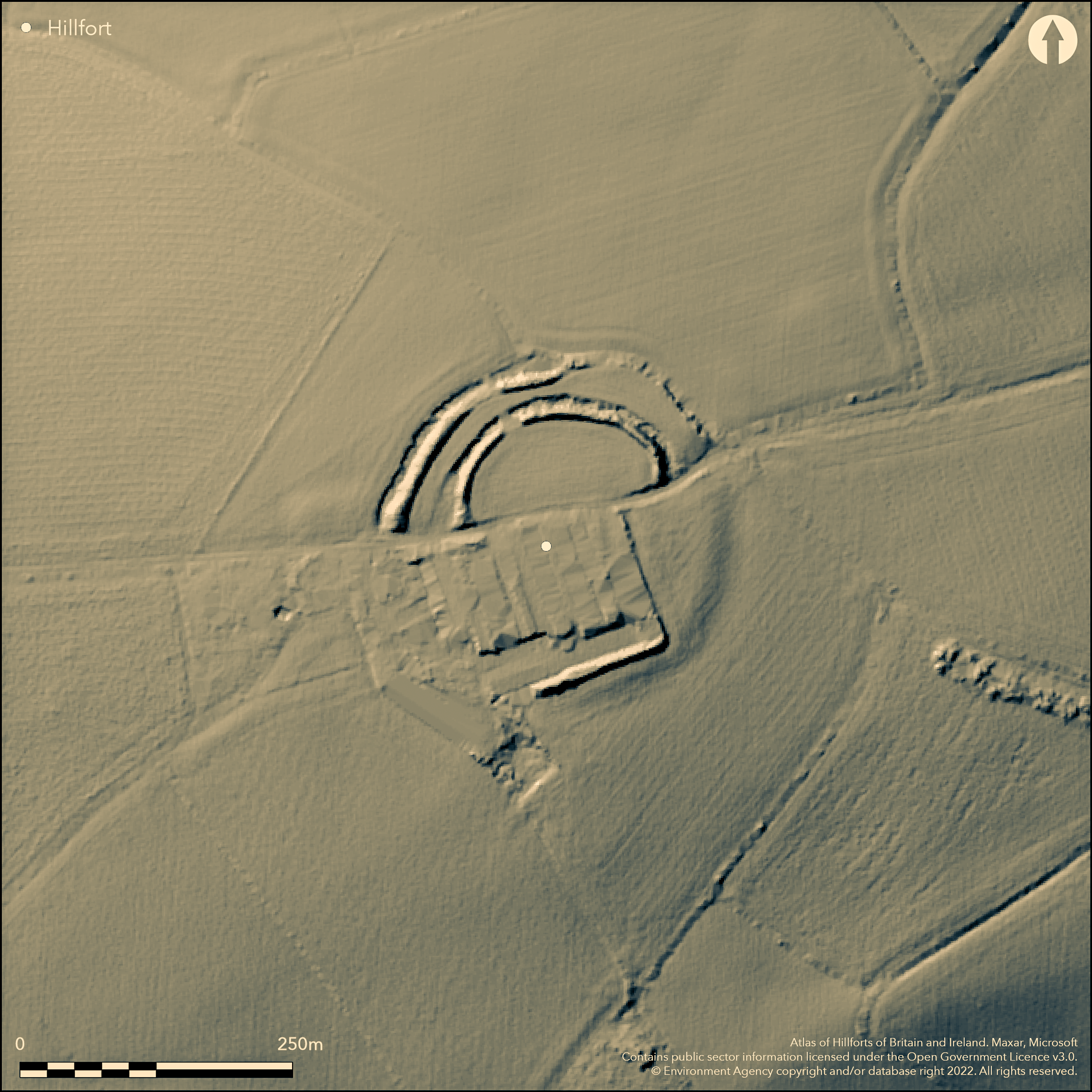
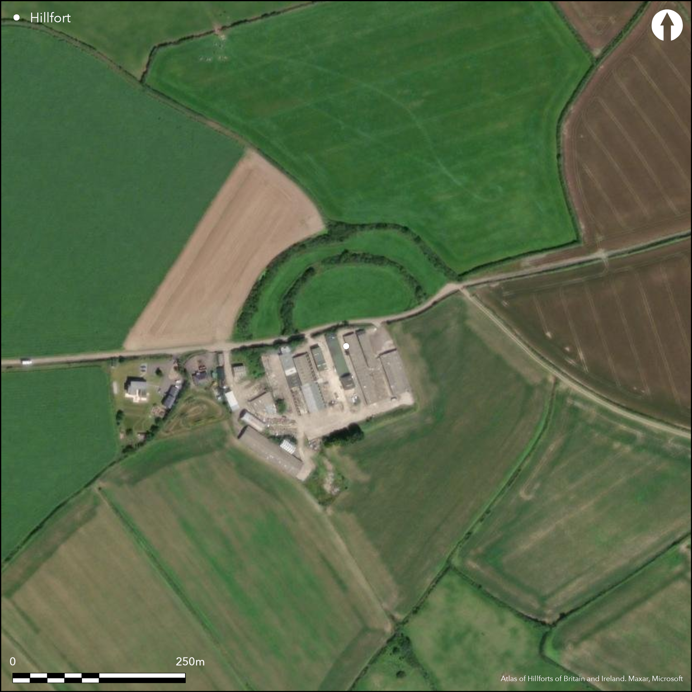
Contour, bivallate, contour hillfort located on summit of low hill in rolling coastal belt between River Camel estuary and Bodmin Moor. Gentle slopes on all sides, dropping to the River Allen on SE side. 3.75km E of head of Camel estuary and close to crossing point of two major cross-country routes: NW-SE across Cornwall using Camel and Fowey valleys, and NE-SW route along N Cornwall avoiding high ground of Bodmin Moor. Sub-circular shape measuring c. 127m by 117m and enclosing c. 5ha. Two massive earth and rubble ramparts and ditches formerly surrounded site, but SW and part SE quadrants now destroyed by farm buildings, although line of rampart can be traced. NNE sector of outer rampart also levelled. Inner rampart to 10m wide and 2m high, with outer ditch 10m wide and 2m deep. Outer rampart running concentric with inner and of similar proportions. Wide gap c. 9m to 18m between inner ditch and outer rampart. Breaks on W and ENE sides, where ditches stop, possible entrances. Break on NNW side, but here ditch continues across gap. Surviving N part of sub-rectangular outwork covering possible W entrance with another, now destroyed, outwork covering possible ENE entrance. Excavations 1974-76 of 210 sq.m adjacent to ploughed down S inner rampart revealed long sequence of timber buildings, including four-post structures and a seven-post framed for the ring beam of a 9m diameter round house. Cornish La Tène decorated pottery (Glastonbury Ware) associated with all structural phases, with a little Cordoned Ware from latter levels. All material for pottery originated from the Lizard. C14 dates suggest occupation from 3rd century BC and, in addition, dates of 930 and 840 BC +- 70, with lugged sherd suggest occupation, possibly within an enclosure, during late Bronze Age. Two small sherds 5th and 6th century AD. Amphora found at plough-soil base suggest post-Roman activity. Slag indicates metal working. Much damaged by farm located on site. On 1st Ed OS map (1881).
Citizen Science: ✗
Reliability of Data: Confirmed
Reliability of Interpretation: Confirmed
X: -534025 Y: 6538385 (EPSG: 3857)
Longitude: -4.797227590554764 Latitude: 50.52892580572799 (EPSG:4326)
Country: England; None
Current County or Unitary Authority: Cornwall
Historic County: Cornwall
Current Parish/Community/Council/Townland: Egloshayle; St. Kew
SW and part SE quadrants now destroyed by cultivation and farm buildings, although line of rampart can be traced. NNE sector of outer rampart also levelled. On Heritage at Risk Register (2015).
| Extant | ✓ |
| Cropmark | ✗ |
| Likely Destroyed | ✓ |
Farmed.
| Woodland | ✗ |
| Commercial Forestry Plantation | ✗ |
| Parkland | ✗ |
| Pasture (Grazing) | ✓ |
| Arable | ✗ |
| Scrub/Bracken | ✗ |
| Bare Outcrop | ✗ |
| Heather/Moorland | ✗ |
| Heath | ✗ |
| Built-up | ✓ |
| Coastal Grassland | ✗ |
| Other | ✗ |
Contour sub-circular hillfort on summit of low hill in rolling coastal belt between River Camel estuary and Bodmin Moor. Gentle slopes on all sides, dropping to the River Allen on SE side. 3.75km E of head of Camel estuary and close to crossing point of two major cross-country routes: NW-SE across Cornwall using Camel and Fowey valleys, and NE-SW route along N Cornwall avoiding high ground of Bodmin Moor.
| Contour Fort | ✓ |
| Partial Contour Fort | ✗ |
| Promontory Fort | ✗ |
| Hillslope Fort | ✗ |
| Level Terrain Fort | ✗ |
| Marsh Fort | ✗ |
| Multiple Enclosure Fort | ✗ |
| Hilltop | ✓ |
| Coastal Promontory | ✗ |
| Inland Promontory | ✗ |
| Valley Bottom | ✗ |
| Knoll/Hillock/Outcrop | ✗ |
| Ridge | ✗ |
| Cliff/Plateau-edge/Scarp | ✗ |
| Hillslope | ✗ |
| Lowland | ✗ |
| Spur | ✗ |
Dominant Topographic Feature: Summit of low hill.
| North | ✗ |
| Northeast | ✗ |
| East | ✗ |
| Southeast | ✗ |
| South | ✗ |
| Southwest | ✗ |
| West | ✗ |
| Northwest | ✗ |
| Level | ✓ |
Altitude: 95.0m
On Parish boundary with St. Kew
Boundary Type: Parish/Townland
C14 dates suggest occupation of the hillfort from the 3rd century BC. In addition dates of 930 and 840 BC +- 70, together with a lugged sherd, also suggest some occupation, possibly within an enclosure, during the late Bronze Age.
Reliability: B - Medium
| Pre 1200BC | ✗ |
| 1200BC - 800BC | ✓ |
| 800BC - 400BC | ✗ |
| 400BC - AD50 | ✓ |
| AD50 - AD400 | ✗ |
| AD400 - AD 800 | ✗ |
| Post AD800 | ✗ |
| Unknown | ✗ |
| Pre Hillfort: | None |
| Post Hillfort: | None |
| Artefactual: | Sherd. |
| C14: | C14 dates suggest occupation of the hillfort from the 3rd century BC and earlier. |
On 1st Ed OS map (1881). Field investigation Ordnance Survey 1972. Trial excavation by P.T. Tredigian 1974. Excavation by H. Miles 1975-76. Watching Brief, Cornwall Archaeological Unit 2011.
| 1st Identified Written Reference (1478): | Early reference - no details. |
| 1st Identified Map Depiction (1881): | OS map. |
| Other (1972): | Field investigation OS. |
| Excavation (1974): | Trial excavation by P.T. Tredigian. |
| Other (1978): | Visit by Hillfort Study Group |
| Other (2011): | Watching Brief, Cornwall Archaeological Unit. |
| Excavation (None): | H. Miles. |
Inner ditch and rampart sectioned, ditch being cut 2.8m into bedrock with primary silt at base. Inner rampart, probably at least two phases, survived only as 0.2m thick disturbed layer of soil and shillet sealing beneath it, in the old land surface, pit containing charcoal. Trial strip between two ramparts produced curved gullies not found in interior. Excavations of 210 sq.m adjacent to ploughed down S inner rampart revealed long sequence of timber buildings, including four-post structures and a seven post framed for the ring beam of a 9m diameter round house. In old land surface, pit containing charcoal. Excavations 1974-76 produced Cornish La Tene decorated pottery (Glastonbury Ware) associated with all structural phases, with a little Cordoned Ware from latter levels. All this material for pottery originated from the Lizard. Amphora also. Plant remains and pollen. Slag indicating metal working.
None
| None | ✓ |
| Spring | ✗ |
| Stream | ✗ |
| Pool | ✗ |
| Flush | ✗ |
| Well | ✗ |
| Other | ✗ |
None
| No Known Features | ✓ |
| Round Stone Structures | ✗ |
| Rectangular Stone Structures | ✗ |
| Curvilinear Platforms | ✗ |
| Other Roundhouse Evidence | ✗ |
| Pits | ✗ |
| Quarry Hollows | ✗ |
| Other | ✗ |
Inner ditch and rampart sectioned, ditch being cut 2.8m into bedrock with primary silt at base. Inner rampart, probably at least two phases, survived only as 0.2m thick disturbed layer of soil and shillet sealing beneath it, in the old land surface, pit containing charcoal. Trial strip between two ramparts produced curved gullies not found in interior. Excavations of 210 sq.m adjacent to ploughed down S inner rampart revealed long sequence of timber buildings, including four-post structures and a seven post framed for the ring beam of a 9m diameter round house.
| No Known Excavation | ✗ |
| Pits | ✓ |
| Postholes | ✗ |
| Roundhouses | ✓ |
| Rectangular Structures | ✓ |
| Roads/Tracks | ✗ |
| Quarry Hollows | ✗ |
| Other | ✓ |
| Nothing Found | ✗ |
None
| No Known Geophysics | ✓ |
| Pits | ✗ |
| Roundhouses | ✗ |
| Rectangular Structures | ✗ |
| Roads/Tracks | ✗ |
| Quarry Hollows | ✗ |
| Other | ✗ |
| Nothing Found | ✗ |
In old land surface, pit containing charcoal. Excavations 1974-76 produced Cornish La Tène decorated pottery (Glastonbury Ware) associated with all structural phases, with a little Cordoned Ware from latter levels. All this material for pottery originated from the Lizard. Amphora also. 165 possible slingstones. Plant remains and pollen. Slag indicating metal working.
| No Known Finds | ✗ |
| Pottery | ✓ |
| Metal | ✗ |
| Metalworking | ✓ |
| Human Bones | ✗ |
| Animal Bones | ✗ |
| Lithics | ✓ |
| Environmental | ✓ |
| Other | ✗ |
None
| APs Not Checked | ✓ |
| None | ✗ |
| Roundhouses | ✗ |
| Rectangular Structures | ✗ |
| Pits | ✗ |
| Postholes | ✗ |
| Roads/Tracks | ✗ |
| Other | ✗ |
Breaks on W and ENE sides, where ditches stop, possible entrances. Break on NNW side, but here ditch continues across gap. Surviving N part of sub-rectangular outwork covering possible W entrance with another, now destroyed, outwork covering possible ENE entrance
| 3: | Break on NNW side possibly not original as here ditch continues across gap. |
| 2: | Possible E and W entrances |
Guard Chambers: ✗
Chevaux de Frise: ✗
| 1. Simple Gap (West): | None |
| 1. Outworks (West): | None |
| 2. Simple Gap (North east): | None |
| 2. Outworks (North east): | None |
Two massive earth and rubble ramparts and ditches formerly surrounded site, but SW and part SE quadrants now destroyed by farm buildings NNE sector of outer rampart also levelled. and Site measures 127m by117m, inner rampart to 10m wide and 2m high, with outer ditch 10m wide and 2m deep. Outer rampart running concentric with inner and of similar proportions . Wide gap of 9m to 18m between inner ditch and outer rampart. Surviving N part of sub-rectangular outwork covering possible W entrance with another, now destroyed, outwork covering ENE entrance.
| Area 1: | 5.0ha. |
| Total: | 5.0ha. |
Total Footprint Area: Noneha.
None
| ✓ | Phased construction. Possibly univallate? |
| ✗ | SW and part SE quadrants now destroyed by farm buildings. NNE sector of outer rampart also levelled. |
| NE Quadrant: | 2 |
| SE Quadrant: | 2 |
| SW Quadrant: | 0 |
| NW Quadrant: | 2 |
| Total: | 2 |
| Partial Univallate | ✗ |
| Univallate | ✗ |
| Partial Bivallate | ✓ |
| Bivallate | ✗ |
| Partial Multivallate | ✗ |
| Multivallate | ✗ |
| Unknown | ✗ |
| Partial Univallate | ✗ |
| Univallate | ✓ |
| Partial Bivallate | ✗ |
| Bivallate | ✗ |
| Partial Multivallate | ✗ |
| Multivallate | ✗ |
None
| None | ✗ |
| Earthen Bank | ✓ |
| Stone Wall | ✗ |
| Rubble | ✓ |
| Wall-walk | ✗ |
| Evidence of Timber | ✗ |
| Vitrification | ✗ |
| Other Burning | ✗ |
| Palisade | ✗ |
| Counter Scarp Bank | ✗ |
| Berm | ✗ |
| Unfinished | ✗ |
| Other | ✗ |
Earth and rubble ramparts.
| None | ✗ |
| Earthen Bank | ✓ |
| Stone Wall | ✓ |
| Murus Duplex | ✗ |
| Timber-framed | ✗ |
| Timber-laced | ✗ |
| Vitrification | ✗ |
| Other Burning | ✗ |
| Palisade | ✗ |
| Counter Scarp Bank | ✗ |
| Berm | ✗ |
| Unfinished | ✗ |
| No Known Excavation | ✗ |
| Other | ✗ |
| ✗ | None |
| ✓ | None |
Number of Ditches: 2
| ✗ | None |
Miles, H. et al 1977. Excavations at Killibury hillfort, Cornish Archaeol, 16, 89-121.
Page, W. ed. 1906. The Victoria History of the County of Cornwall, 1, London: James Street, 459.
Taylor S.R. 2011. Benbole Farm Solar Array Electricity Cable Trenching, Unpublished assessment and evaluation Report No 11R084, Cornwall Archaeological Unit, Cornwall County Council,
Atlas of Hillforts:
Wikidata:
This work is licensed under CC BY-SA 4.0![]()
![]()
![]() and should be cited as:
and should be cited as:
Lock, Gary and Ralston, Ian. 2024. Atlas of Hillforts of Britain and Ireland. Available at: https://hillforts.arch.ox.ac.uk
Document Version 1.1