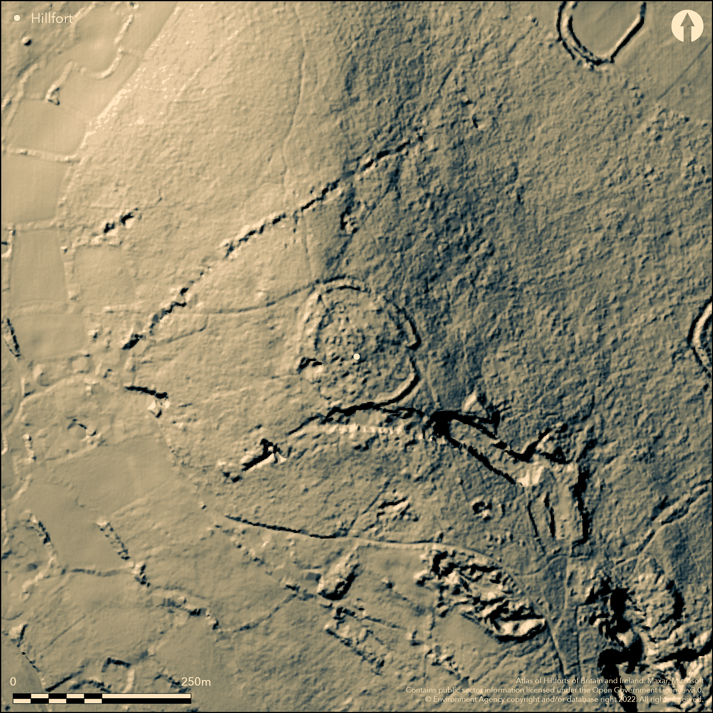
LiDAR 1m DTM Hillshade
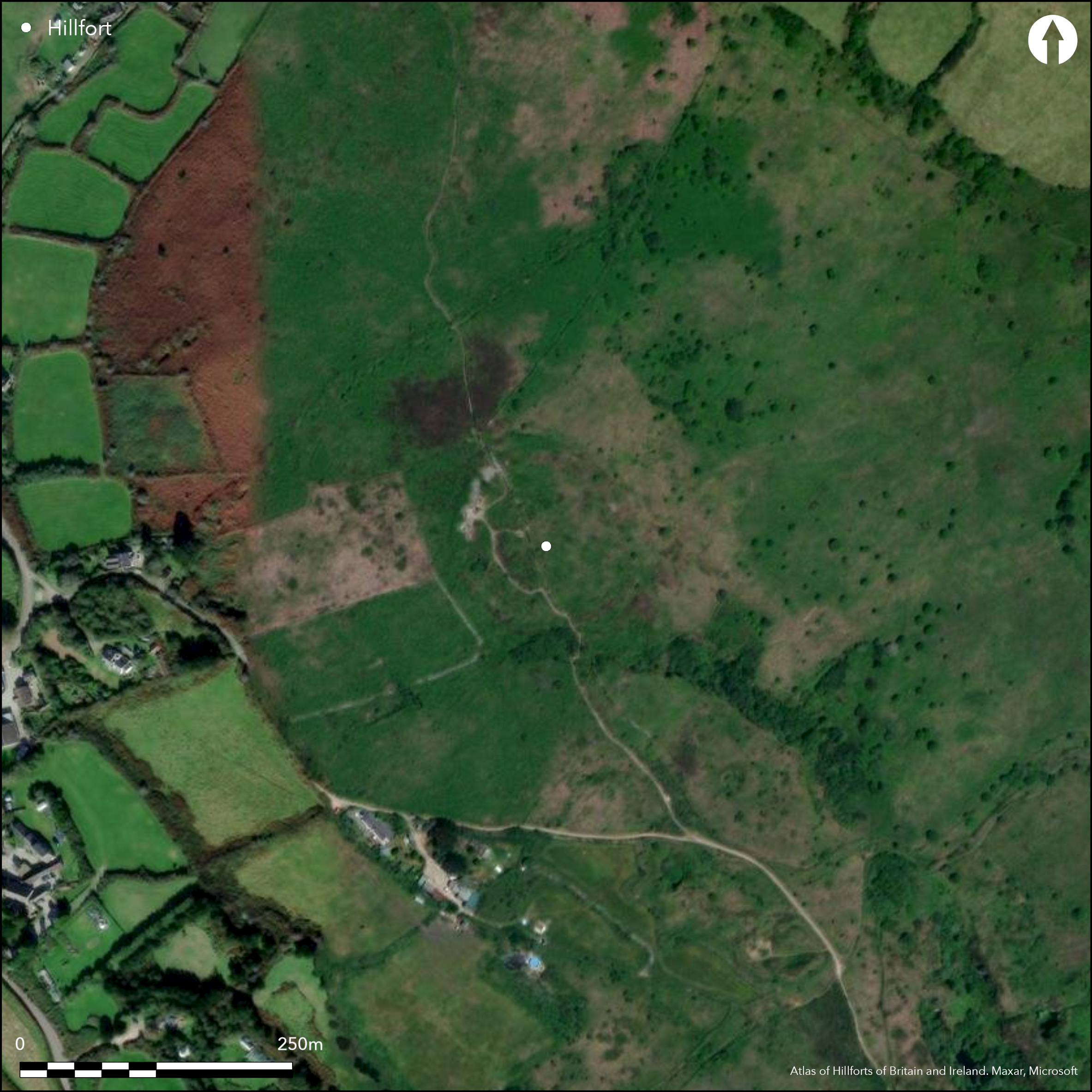
Satellite Imagery
LiDAR 1m DTM Hillshade
Satellite Imagery
Scroll left/right to view further images.
HER: Cornwall and Scilly MCO53 (29247)
NMR: SW 53 SE 8 (424956)
SM: 1007293
NGR: SW5994330040
X: 159943 Y: 30040 (OSGB36)
Bivallate, stone walled, partial contour hillfort located on prominent Tregonning Hill, one of two granite hills in area. Steep surrounding slopes to N, E, W, moderate along ridge of hill to SE. Oval shape enclosing c. 0.7ha. Two concentric stone ramparts and ditches, to 2.6m high where outer wall best preserved on N and S, with outer ditch to 0.6m deep, all partly cut by later mining. Much of ramparts tumbled with extensive quarrying over area. Multi-period landscape includes Castle Pencaire, barrows, two rounds to NE and E, field system between hillfort and the rounds, 18th century watch house, extensive mineral working and prospecting pits, and part of china clay works where William Cookworthy discovered china clay. Also listed war memorial and OS Trig Point within hillfort. Outer rampart best and up to 2.6m high on N and S, with outer ditch 0.6m deep. Aerial photographs suggest potential internal structures and hut circles, but many small circular later quarry pits throughout interior and these 15-20 'hut circles' could be the result of this later activity. Possible E entrance and inturned entrance on SW, but this latter questioned. Noted by antiquarians as traditionally 'the home of giants'. Field systems possibly contemporary with hillfort and two rounds; also with possible medieval connotations. Very overgrown moorland site with scrub. On 1st Ed. OS map (1878). Undated.
Citizen Science: ✗
Reliability of Data: Confirmed
Reliability of Interpretation: Confirmed
X: -596648 Y: 6467380 (EPSG: 3857)
Longitude: -5.359779551165996 Latitude: 50.12170780224752 (EPSG:4326)
Country: England; None
Current County or Unitary Authority: Cornwall
Historic County: Cornwall
Current Parish/Community/Council/Townland: Breage; Germoe
Ramparts tumbled and site extensively quarried over area. On Heritage at Risk Register (2015).
| Extant | ✓ |
| Cropmark | ✗ |
| Likely Destroyed | ✓ |
Very overgrown moorland site with scrub. Quarried over. Listed war memorial and OS Trig Point within hillfort.
| Woodland | ✗ |
| Commercial Forestry Plantation | ✗ |
| Parkland | ✗ |
| Pasture (Grazing) | ✗ |
| Arable | ✗ |
| Scrub/Bracken | ✗ |
| Bare Outcrop | ✗ |
| Heather/Moorland | ✓ |
| Heath | ✗ |
| Built-up | ✗ |
| Coastal Grassland | ✗ |
| Other | ✓ |
Bivallate, stone walled, partial contour hillfort located on prominent Tregonning Hill, one of two granite hills in area. Steep surrounding slopes to N, E, W, moderate along ridge of hill to SE.
| Contour Fort | ✗ |
| Partial Contour Fort | ✓ |
| Promontory Fort | ✗ |
| Hillslope Fort | ✗ |
| Level Terrain Fort | ✗ |
| Marsh Fort | ✗ |
| Multiple Enclosure Fort | ✗ |
Situated on the top north-western part of Tregonning Hill
| Hilltop | ✓ |
| Coastal Promontory | ✗ |
| Inland Promontory | ✗ |
| Valley Bottom | ✗ |
| Knoll/Hillock/Outcrop | ✗ |
| Ridge | ✗ |
| Cliff/Plateau-edge/Scarp | ✗ |
| Hillslope | ✗ |
| Lowland | ✗ |
| Spur | ✗ |
Dominant Topographic Feature: Hill top
| North | ✗ |
| Northeast | ✗ |
| East | ✗ |
| Southeast | ✗ |
| South | ✗ |
| Southwest | ✗ |
| West | ✗ |
| Northwest | ✗ |
| Level | ✓ |
Altitude: 194.0m
Boundary Type: Parish/Townland
None.
Reliability: D - None
| Pre 1200BC | ✗ |
| 1200BC - 800BC | ✗ |
| 800BC - 400BC | ✗ |
| 400BC - AD50 | ✗ |
| AD50 - AD400 | ✗ |
| AD400 - AD 800 | ✗ |
| Post AD800 | ✗ |
| Unknown | ✓ |
| Pre Hillfort: | Castle Pencaire, barrows. |
| Post Hillfort: | Listed war memorial and OS Trig Point within hillfort. |
First mentioned by Leland 1540. On estate map of 1770 site called Loben Rath - possibly from 'Lom Rath', 'the deserted castle'. Described by Thomas 1851 - no details. On 1st Ed. OS map (1878). Field investigation Ordnance Survey 1971.
| 1st Identified Written Reference (1540): | First mentioned by Leland. |
| 1st Identified Map Depiction (1770): | Estate map. |
| Other (1851): | Described by Thomas - no details. |
| Other (1878): | OS map. |
| Other (1971): | Field investigation OS. |
Aerial photographs suggest potential internal structures and hut circles, but many small circular later quarry pits throughout the interior and these 15-20 'hut circles' could be result of this later activity.
None
| None | ✓ |
| Spring | ✗ |
| Stream | ✗ |
| Pool | ✗ |
| Flush | ✗ |
| Well | ✗ |
| Other | ✗ |
Small circular later quarry pits throughout the interior, but the 15-20 'hut circles' could be result of this later activity.
| No Known Features | ✗ |
| Round Stone Structures | ✗ |
| Rectangular Stone Structures | ✗ |
| Curvilinear Platforms | ✓ |
| Other Roundhouse Evidence | ✗ |
| Pits | ✗ |
| Quarry Hollows | ✓ |
| Other | ✗ |
None
| No Known Excavation | ✓ |
| Pits | ✗ |
| Postholes | ✗ |
| Roundhouses | ✗ |
| Rectangular Structures | ✗ |
| Roads/Tracks | ✗ |
| Quarry Hollows | ✗ |
| Other | ✗ |
| Nothing Found | ✗ |
None
| No Known Geophysics | ✓ |
| Pits | ✗ |
| Roundhouses | ✗ |
| Rectangular Structures | ✗ |
| Roads/Tracks | ✗ |
| Quarry Hollows | ✗ |
| Other | ✗ |
| Nothing Found | ✗ |
None
| No Known Finds | ✓ |
| Pottery | ✗ |
| Metal | ✗ |
| Metalworking | ✗ |
| Human Bones | ✗ |
| Animal Bones | ✗ |
| Lithics | ✗ |
| Environmental | ✗ |
| Other | ✗ |
Aerial photographs suggest potential internal structures and hut circles, but many small circular later quarry pits throughout the interior and these 15-20 'hut circles' could be result of this later activity.
| APs Not Checked | ✗ |
| None | ✗ |
| Roundhouses | ✓ |
| Rectangular Structures | ✗ |
| Pits | ✗ |
| Postholes | ✗ |
| Roads/Tracks | ✗ |
| Other | ✓ |
Possible E entrance, but possible in-turned entrance on SW, but this has been questioned.
| 2: | None |
| 2: | None |
Guard Chambers: ✗
Chevaux de Frise: ✗
| 1. Simple Gap (East): | None |
| 2. In-turned (South west): | Questioned. |
Site enclosed by two concentric stone ramparts and ditches, to 2.6m high where outer wall best preserved on N and S, with the outer ditch to 0.6m deep, all partly cut by later mining activity. Much of ramparts tumbled with extensive quarrying over area.
| Area 1: | 0.7ha. |
| Total: | 0.7ha. |
Total Footprint Area: Noneha.
None
| ✗ | None |
| ✓ | None |
| NE Quadrant: | 2 |
| SE Quadrant: | 2 |
| SW Quadrant: | 2 |
| NW Quadrant: | 2 |
| Total: | 2 |
| Partial Univallate | ✗ |
| Univallate | ✗ |
| Partial Bivallate | ✗ |
| Bivallate | ✓ |
| Partial Multivallate | ✗ |
| Multivallate | ✗ |
| Unknown | ✗ |
| Partial Univallate | ✗ |
| Univallate | ✗ |
| Partial Bivallate | ✗ |
| Bivallate | ✗ |
| Partial Multivallate | ✗ |
| Multivallate | ✗ |
None
| None | ✗ |
| Earthen Bank | ✗ |
| Stone Wall | ✓ |
| Rubble | ✓ |
| Wall-walk | ✗ |
| Evidence of Timber | ✗ |
| Vitrification | ✗ |
| Other Burning | ✗ |
| Palisade | ✗ |
| Counter Scarp Bank | ✗ |
| Berm | ✗ |
| Unfinished | ✗ |
| Other | ✗ |
None
| None | ✗ |
| Earthen Bank | ✗ |
| Stone Wall | ✗ |
| Murus Duplex | ✗ |
| Timber-framed | ✗ |
| Timber-laced | ✗ |
| Vitrification | ✗ |
| Other Burning | ✗ |
| Palisade | ✗ |
| Counter Scarp Bank | ✗ |
| Berm | ✗ |
| Unfinished | ✗ |
| No Known Excavation | ✓ |
| Other | ✗ |
| ✗ | None |
| ✓ | Possibly two. |
Number of Ditches: 2
| ✗ | None |
Hencken, H.O. 1932. The Archaeology of Cornwall and Scilly, 142-143, 216, 297.
Hitchins, F. and Drew, S. eds. 1824. The History of Cornwall, Vol 2, 108-109.
Lysons, D. and Lysons, S. 1814. Magna Britannia, Vol III, Cornwall, CCXLIX.
Page, W. ed. 1906. The Victoria History of the County of Cornwall, 1, London: James Street, 460.
Polsue, J. ed. 1867-72. Lake's Parochial History of Cornwall, Vol 1, 136.
Atlas of Hillforts:
Wikidata:
This work is licensed under CC BY-SA 4.0

 and should be cited as:
Lock, Gary and Ralston, Ian. 2024. Atlas of Hillforts of Britain and Ireland. Available at: https://hillforts.arch.ox.ac.uk
Document Version 1.1