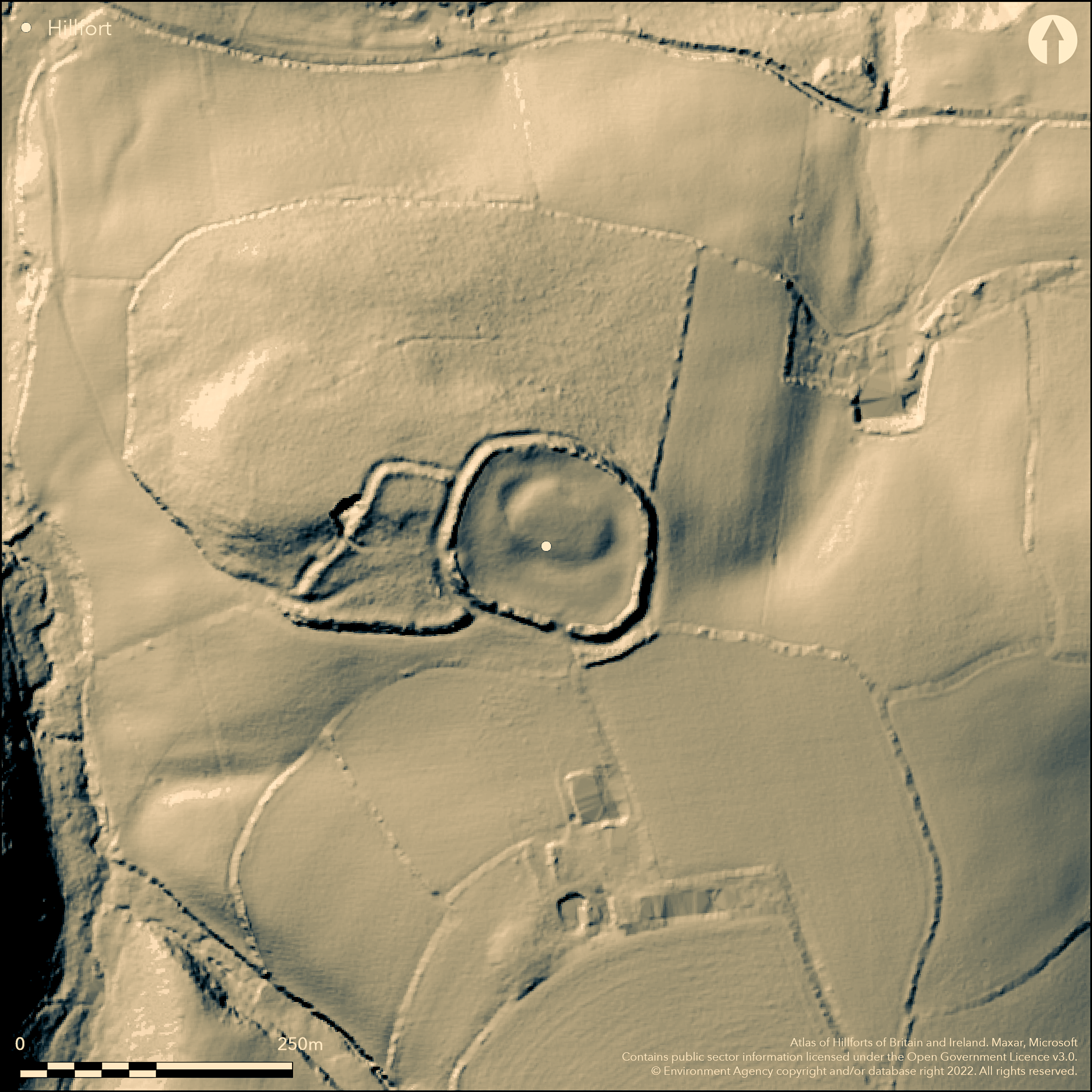
LiDAR 1m DTM Hillshade
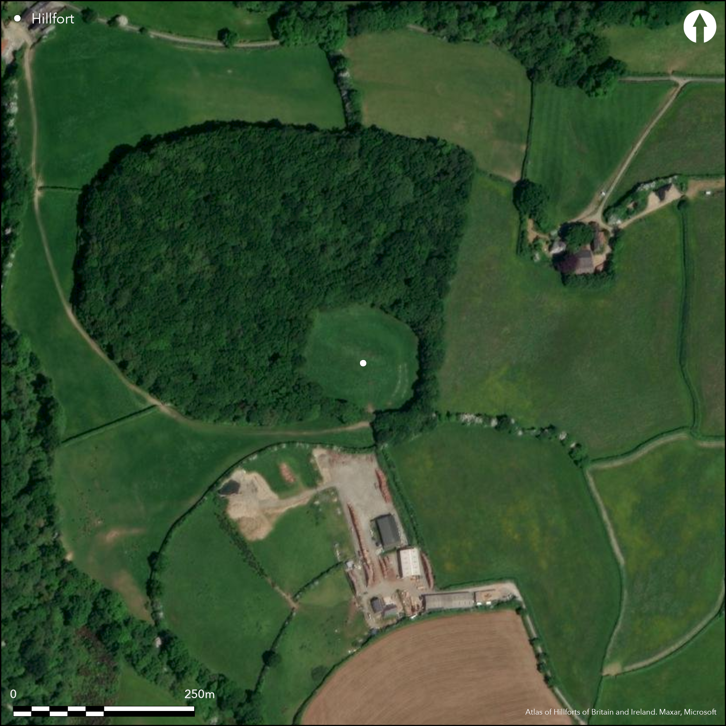
Satellite Imagery
LiDAR 1m DTM Hillshade
Satellite Imagery
Scroll left/right to view further images.
HER: Cornwall and Scilly MCO67 (17572)
NMR: SX 28 SE 5 (436246)
SM: 1004243
NGR: SX 2895 8462
X: 228959 Y: 84629 (OSGB36)
Unusual, complex, multiple enclosure hillfort sited on summit ridge directly overlooking steep valley of River Kensey. Oval inner enclosed area, with surrounding oval middle enclosure and, to W, outer enclosure forming roughly-triangular annexe. Total area enclosed c. 1.4ha. Inner enclosure c. 50m by 30m with 2m, high raised platform, with wide and mostly buried ditch to 16m wide and has having causewayed entrance, 6m wide, to W. Middle enclosure c. 110m by 100m with rampart to 5m high above partly buried outer ditch with 1m high counterscarp bank. Inner side of rampart part cut to form field boundary. To W simple causewayed entrance leads to outer annexe c. 140m by 120m. The annexe (0.5ha) has bank to 2.5m high and 0.6m deep outer ditch. Simple entrance approached by hollow way at SW corner. Quarry cuts into rampart and outer ditch. To N track follows line of the ditch. First described by Lake in 1872. Partial excavations by O.B. Peter 1902 found spindle whorls, ground stone hammer or mace head, flint, nodules of iron pyrites and sea pebbles. Trench dug near foot of inner slope of annexe rampart found foundations of two walls, hearth with blackened stones and stone and clay 'oven'. In wall, rubble wheel-turned fragment of blackened vessel, possibly post-Roman. Occupation debris also suggested Neolithic or Bronze Age settlement, with possible medieval reuse of annexe revealed by medieval hut. Interior pasture. Banks under woodland to N and W, tree and scrub growth to E and S (lesser). Damaged, but parts survive well. On 1st Ed. OS map (1884).
Citizen Science: ✗
Reliability of Data: Confirmed
Reliability of Interpretation: Confirmed
X: -492051 Y: 6557180 (EPSG: 3857)
Longitude: -4.42017104276704 Latitude: 50.63613059212188 (EPSG:4326)
Country: England
Current County or Unitary Authority: Cornwall
Historic County: Cornwall
Current Parish/Community/Council/Townland: St Thomas the Apostle Rural
Quarry and plough damage. Inner side of middle rampart part cut to form field boundary. Also part early excavation and S entrance damage, but generally survives well. N rampart particularly fine.
| Extant | ✓ |
| Cropmark | ✗ |
| Likely Destroyed | ✗ |
Interior pasture. Banks under woodland to N and W, tree and scrub growth to E and S (lesser). Quarrying.
| Woodland | ✓ |
| Commercial Forestry Plantation | ✗ |
| Parkland | ✗ |
| Pasture (Grazing) | ✓ |
| Arable | ✗ |
| Scrub/Bracken | ✗ |
| Bare Outcrop | ✗ |
| Heather/Moorland | ✗ |
| Heath | ✗ |
| Built-up | ✗ |
| Coastal Grassland | ✗ |
| Other | ✓ |
Unusual, complex, multiple enclosure hillfort sited on summit ridge directly overlooking steep valley of River Kensey.
| Contour Fort | ✗ |
| Partial Contour Fort | ✗ |
| Promontory Fort | ✗ |
| Hillslope Fort | ✗ |
| Level Terrain Fort | ✗ |
| Marsh Fort | ✗ |
| Multiple Enclosure Fort | ✓ |
| Hilltop | ✗ |
| Coastal Promontory | ✗ |
| Inland Promontory | ✗ |
| Valley Bottom | ✗ |
| Knoll/Hillock/Outcrop | ✗ |
| Ridge | ✓ |
| Cliff/Plateau-edge/Scarp | ✗ |
| Hillslope | ✗ |
| Lowland | ✗ |
| Spur | ✗ |
Dominant Topographic Feature: Ridge
| North | ✗ |
| Northeast | ✗ |
| East | ✗ |
| Southeast | ✗ |
| South | ✗ |
| Southwest | ✗ |
| West | ✗ |
| Northwest | ✗ |
| Level | ✓ |
Altitude: 153.0m
N/A
Finds indicate Iron Age occupation.
Reliability: B - Medium
| Pre 1200BC | ✗ |
| 1200BC - 800BC | ✗ |
| 800BC - 400BC | ✗ |
| 400BC - AD50 | ✓ |
| AD50 - AD400 | ✗ |
| AD400 - AD 800 | ✗ |
| Post AD800 | ✗ |
| Unknown | ✗ |
| Pre Hillfort: | None |
| Post Hillfort: | None |
| Artefactual: | General finds dating. |
On 1st Ed. OS map (1884). First described in 'Lake's Parochial History of Cornwall' in 1872. Partial excavations by O.B. Peter c. 1902. Field investigation Ordnance Survey 1974.
| 1st Identified Written Reference (1872): | Lake's parochial history description. |
| 1st Identified Map Depiction (1884): | OS map. |
| Other (1974): | Field investigation OS. |
| Excavation (None): | O.B. Peter. |
Excavation found spindle whorls, ground stone hammer or mace head, flint, nodules of iron pyrites and sea pebbles. Trench dug near foot of inner slope of annexe rampart, under cart track leading to the quarry, found foundations of two walls, hearth with blackened stones and stone and clay 'oven'. In wall, rubble wheel-turned fragment of blackened vessel, possibly post-Roman. Occupation debris also suggested Neolithic or Bronze Age settlement, with possible medieval reuse of annexe revealed by medieval hut.
None
| None | ✓ |
| Spring | ✗ |
| Stream | ✗ |
| Pool | ✗ |
| Flush | ✗ |
| Well | ✗ |
| Other | ✗ |
None
| No Known Features | ✓ |
| Round Stone Structures | ✗ |
| Rectangular Stone Structures | ✗ |
| Curvilinear Platforms | ✗ |
| Other Roundhouse Evidence | ✗ |
| Pits | ✗ |
| Quarry Hollows | ✗ |
| Other | ✗ |
Trench dug near foot of inner slope of annexe rampart, under cart track leading to the quarry, found foundations of two walls, hearth with blackened stones and stone and clay 'oven'.
| No Known Excavation | ✗ |
| Pits | ✗ |
| Postholes | ✗ |
| Roundhouses | ✗ |
| Rectangular Structures | ✗ |
| Roads/Tracks | ✗ |
| Quarry Hollows | ✗ |
| Other | ✓ |
| Nothing Found | ✗ |
None
| No Known Geophysics | ✓ |
| Pits | ✗ |
| Roundhouses | ✗ |
| Rectangular Structures | ✗ |
| Roads/Tracks | ✗ |
| Quarry Hollows | ✗ |
| Other | ✗ |
| Nothing Found | ✗ |
Excavation found spindle whorls, ground stone hammer or mace head, flint, nodules of iron pyrites and sea pebbles. Trench dug near foot of inner slope of annexe rampart, under cart track leading to the quarry, had foundations of two walls, hearth with blackened stones and stone and clay 'oven'. In wall rubble wheel-turned fragment of blackened vessel, possibly post-Roman. Occupation debris also suggested Neolithic or Bronze Age settlement, with possible medieval reuse of annexe revealed by medieval hut.
| No Known Finds | ✗ |
| Pottery | ✓ |
| Metal | ✗ |
| Metalworking | ✗ |
| Human Bones | ✗ |
| Animal Bones | ✗ |
| Lithics | ✓ |
| Environmental | ✗ |
| Other | ✓ |
None
| APs Not Checked | ✓ |
| None | ✗ |
| Roundhouses | ✗ |
| Rectangular Structures | ✗ |
| Pits | ✗ |
| Postholes | ✗ |
| Roads/Tracks | ✗ |
| Other | ✗ |
Inner enclosure has causewayed entrance, 6m wide, to W. Middle enclosure has to W simple causewayed entrance leading to outer annexe. Annexe has simple entrance to outside approached by a hollow way at SW corner.
| 3: | None |
| 2: | None |
Guard Chambers: ✗
Chevaux de Frise: ✗
| 1. Simple Gap (West): | Inner enclosure causewayed entrance. |
| 2. Simple Gap (West): | Middle enclosure simple causewayed entrance leading to outer annexe. |
Inner enclosure c. 50m by 30m with 2m high raised platform, with wide and mostly buried ditch to16m wide and has having causewayed entrance, 6m wide, to W. Middle enclosure c.110m by 100m with rampart to 5m high above partly buried outer ditch with 1m high counterscarp bank. Inner side of rampart part cut to form field boundary. To W simple causewayed entrance leads to outer annexe c. 140m by 120m. The annexe, to 0.5ha, has bank to 2.5m high and 0.6m deep outer ditch.
| Area 1: | 1.4ha. |
| Total: | 1.4ha. |
Total Footprint Area: Noneha.
None
| ✗ | Total area enclosed c. 1.4ha (main enclosures c. 0.9ha, annexe of 0.5ha) |
| ✓ | Annexe rampart not included. |
| NE Quadrant: | 2 |
| SE Quadrant: | 2 |
| SW Quadrant: | 2 |
| NW Quadrant: | 2 |
| Total: | 2 |
| Partial Univallate | ✗ |
| Univallate | ✗ |
| Partial Bivallate | ✗ |
| Bivallate | ✓ |
| Partial Multivallate | ✗ |
| Multivallate | ✗ |
| Unknown | ✗ |
| Partial Univallate | ✗ |
| Univallate | ✗ |
| Partial Bivallate | ✗ |
| Bivallate | ✗ |
| Partial Multivallate | ✗ |
| Multivallate | ✗ |
Counterscarp to middle enclosure.
| None | ✗ |
| Earthen Bank | ✓ |
| Stone Wall | ✗ |
| Rubble | ✗ |
| Wall-walk | ✗ |
| Evidence of Timber | ✗ |
| Vitrification | ✗ |
| Other Burning | ✗ |
| Palisade | ✗ |
| Counter Scarp Bank | ✓ |
| Berm | ✗ |
| Unfinished | ✗ |
| Other | ✗ |
Trench dug near foot of inner slope of annexe rampart found foundations of two walls, hearth with blackened stones and stone and clay 'oven'.
| None | ✗ |
| Earthen Bank | ✗ |
| Stone Wall | ✗ |
| Murus Duplex | ✗ |
| Timber-framed | ✗ |
| Timber-laced | ✗ |
| Vitrification | ✗ |
| Other Burning | ✗ |
| Palisade | ✗ |
| Counter Scarp Bank | ✗ |
| Berm | ✗ |
| Unfinished | ✗ |
| No Known Excavation | ✗ |
| Other | ✓ |
| ✗ | None |
| ✓ | Annexe ditch included. |
Number of Ditches: 3
| ✓ | To W simple causewayed entrance leads to outer annexe c. 140m by 120m. The annexe, to 0.5ha, has bank to 2.5m high and 0.6m deep outer ditch. Simple entrance approached by a hollow way at SW corner. Trench dug near foot of inner slope of annexe rampart, under cart track leading to the quarry, had foundations of two walls, hearth with blackened stones and stone and clay 'oven'. In wall rubble wheel-turned fragment of blackened vessel, possibly post-Roman. Occupation debris also suggested Neolithic or Bronze Age settlement with possible medieval reuse of annexe revealed by medieval hut. Middle enclosure has to W simple causewayed entrance leading to outer annexe. |
Anon 1872. A complete parochial history of the County of Cornwall, London and Truro: J. C. Hotten and W. Lake.
Hencken, H.O. 1932. The Archaeology of Cornwall and Scilly, 128, 309.
Page, W. ed. 1906. The Victoria History of the County of Cornwall, 1, London: James Street, 464.
Peter, O.B. 1902. The ancient earth-fenced town and village sites of Cornwall, J Royal Inst Cornwall, 15, 116-17.
Atlas of Hillforts:
Wikidata:
This work is licensed under CC BY-SA 4.0

 and should be cited as:
Lock, Gary and Ralston, Ian. 2024. Atlas of Hillforts of Britain and Ireland. Available at: https://hillforts.arch.ox.ac.uk
Document Version 1.1