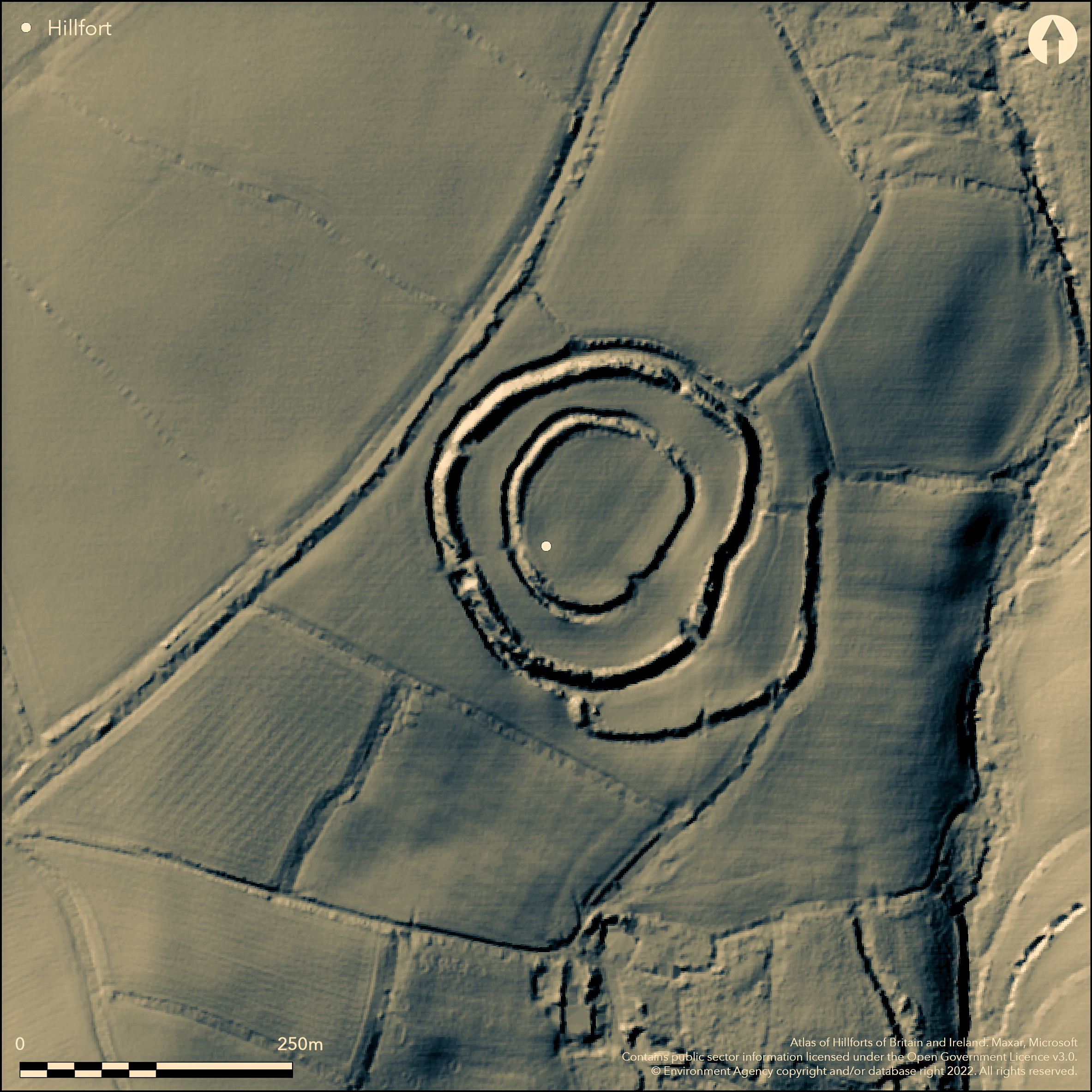
LiDAR 1m DTM Hillshade
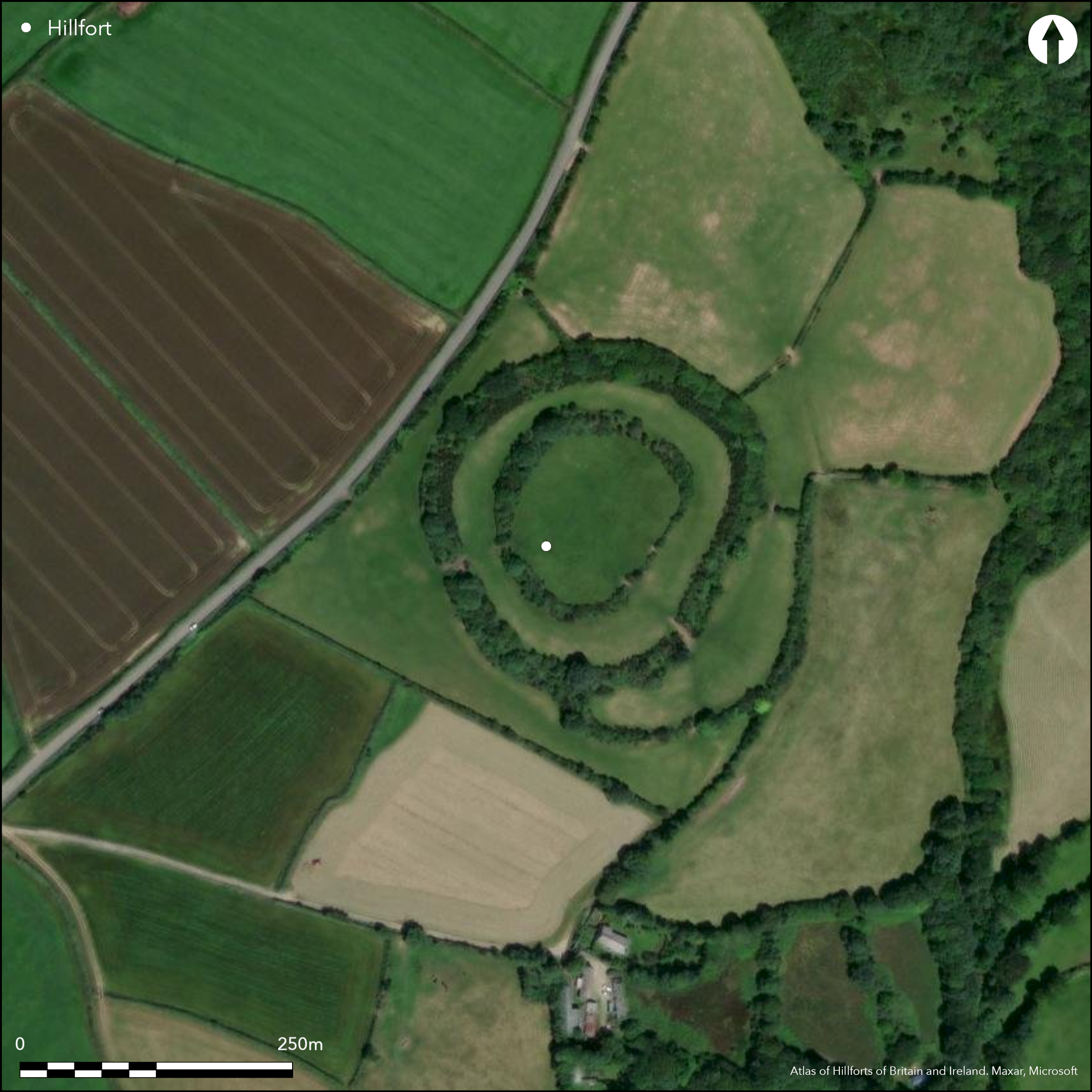
Satellite Imagery
LiDAR 1m DTM Hillshade
Satellite Imagery
Scroll left/right to view further images.
HER: Cornwall and Scilly MCO85 (17894)
NMR: SX 08 SW 1 (432055)
SM: 1006662
NGR: SX03338003
X: 203300 Y: 80030 (OSGB36)
Multiple enclosure hillfort sited on gentle NW-facing upper slope of prominent ridge overlooking the valley of a tributary to the River Allen. Near circular inner enclosure measures to 90m in diameter internally, enclosing 0.8ha, with slight rampart of c. 2m high and outer ditch to 1.7m deep, with second concentric enclosure of c. 120m in diameter internally, with more prominent rampart c. 3m in height and ditch 1.7m deep, enclosing 2.5ha. On NW post medieval 'hull', or underground storage chamber for potatoes, cheese and other foodstuffs, 15m long and 1.7m high, constructed into outer rampart and accessed from the ditch. Further curving outwork to S and E now a low scarp. Original entrance in SE with hollow way. Partial excavation by Rev S. Baring-Gould et al in 1902 found occupation limited to between the two ramparts. The finds reported from the excavation consisted mainly of slingstones, perforated stones, spindle whorls and Iron Age pottery. Suggested that inner enclosure used chiefly as an animal pound, but there is no direct evidence for this. Pasture interiors, trees and scrub on banks and generally survives well. On 1st Ed. OS map (1881).
Citizen Science: ✗
Reliability of Data: Confirmed
Reliability of Interpretation: Confirmed
X: -532126 Y: 6548513 (EPSG: 3857)
Longitude: -4.780165867702242 Latitude: 50.58672376376136 (EPSG:4326)
Country: England; None
Current County or Unitary Authority: Cornwall
Historic County: Cornwall
Current Parish/Community/Council/Townland: St Kew; St Endellion
Survives well.
| Extant | ✓ |
| Cropmark | ✗ |
| Likely Destroyed | ✗ |
Pasture interiors, trees and scrub on banks
| Woodland | ✗ |
| Commercial Forestry Plantation | ✗ |
| Parkland | ✗ |
| Pasture (Grazing) | ✓ |
| Arable | ✗ |
| Scrub/Bracken | ✓ |
| Bare Outcrop | ✗ |
| Heather/Moorland | ✗ |
| Heath | ✗ |
| Built-up | ✗ |
| Coastal Grassland | ✗ |
| Other | ✗ |
Multiple enclosure hillslope hillfort, of concentric form, sited on gentle NW-facing upper slope of prominent ridge overlooking the valley of a tributary to the River Allen.
| Contour Fort | ✗ |
| Partial Contour Fort | ✗ |
| Promontory Fort | ✗ |
| Hillslope Fort | ✗ |
| Level Terrain Fort | ✗ |
| Marsh Fort | ✗ |
| Multiple Enclosure Fort | ✓ |
| Hilltop | ✗ |
| Coastal Promontory | ✗ |
| Inland Promontory | ✗ |
| Valley Bottom | ✗ |
| Knoll/Hillock/Outcrop | ✗ |
| Ridge | ✓ |
| Cliff/Plateau-edge/Scarp | ✗ |
| Hillslope | ✗ |
| Lowland | ✗ |
| Spur | ✗ |
Dominant Topographic Feature: Prominent ridge.
| North | ✗ |
| Northeast | ✗ |
| East | ✗ |
| Southeast | ✗ |
| South | ✗ |
| Southwest | ✗ |
| West | ✗ |
| Northwest | ✓ |
| Level | ✗ |
Altitude: 149.0m
Close to parish boundary
Boundary Type: Parish/Townland
Iron Age pottery.
Reliability: B - Medium
| Pre 1200BC | ✗ |
| 1200BC - 800BC | ✗ |
| 800BC - 400BC | ✗ |
| 400BC - AD50 | ✓ |
| AD50 - AD400 | ✗ |
| AD400 - AD 800 | ✗ |
| Post AD800 | ✗ |
| Unknown | ✗ |
| Pre Hillfort: | None |
| Post Hillfort: | None |
| Artefactual: | Iron Age pottery. |
On 1st Ed. OS map (1881). Partial excavation by Rev S. Baring-Gould et al 1902. Field investigation Ordnance Survey 1971.
| 1st Identified Map Depiction (1881): | OS map. |
| Excavation (1902): | S. Baring-Gould et al. |
| Other (1971): | Field investigation OS. |
| Other (1978): | Visit by Hillfort Study Group |
Partial excavation by S Baring Gould 1902 found occupation limited to between the two ramparts. Finds include Iron Age pottery, slingstones, perforated stones, spindle whorls.
None
| None | ✓ |
| Spring | ✗ |
| Stream | ✗ |
| Pool | ✗ |
| Flush | ✗ |
| Well | ✗ |
| Other | ✗ |
None
| No Known Features | ✓ |
| Round Stone Structures | ✗ |
| Rectangular Stone Structures | ✗ |
| Curvilinear Platforms | ✗ |
| Other Roundhouse Evidence | ✗ |
| Pits | ✗ |
| Quarry Hollows | ✗ |
| Other | ✗ |
Partial excavation by S Baring Gould 1902 found occupation limited to between the two ramparts.
| No Known Excavation | ✗ |
| Pits | ✗ |
| Postholes | ✗ |
| Roundhouses | ✗ |
| Rectangular Structures | ✗ |
| Roads/Tracks | ✗ |
| Quarry Hollows | ✗ |
| Other | ✓ |
| Nothing Found | ✗ |
None
| No Known Geophysics | ✓ |
| Pits | ✗ |
| Roundhouses | ✗ |
| Rectangular Structures | ✗ |
| Roads/Tracks | ✗ |
| Quarry Hollows | ✗ |
| Other | ✗ |
| Nothing Found | ✗ |
Finds include Iron Age pottery, slingstones, perforated stones, spindle whorls.
| No Known Finds | ✗ |
| Pottery | ✓ |
| Metal | ✗ |
| Metalworking | ✗ |
| Human Bones | ✗ |
| Animal Bones | ✗ |
| Lithics | ✓ |
| Environmental | ✗ |
| Other | ✓ |
None
| APs Not Checked | ✓ |
| None | ✗ |
| Roundhouses | ✗ |
| Rectangular Structures | ✗ |
| Pits | ✗ |
| Postholes | ✗ |
| Roads/Tracks | ✗ |
| Other | ✗ |
Simple SE entrance with well-defined hollow way. Five modern part gaps in outer circuit.
| 6: | Five modern part gaps in outer circuit. |
| 2: | None |
Guard Chambers: ✗
Chevaux de Frise: ✗
| 1. Hollow Way (South east): | None |
Near circular inner enclosure measures to 90m in diameter internally, with slight rampart of c. 2m high and outer ditch to 1.7m deep, with second concentric enclosure c.120m in diameter internally with more prominent rampart c. 3m in height and ditch 1.7m deep. On NW post medieval hull, or underground storage chamber, 15m long and 1.7m high constructed into rampart accessed from the ditch. Further curving outwork to S and E now a low scarp.
| Area 1: | 0.8ha. |
| Area 2: | 2.5ha. |
| Total: | 2.5ha. |
Total Footprint Area: Noneha.
None
| ✗ | None |
| ✓ | None |
| NE Quadrant: | 2 |
| SE Quadrant: | 2 |
| SW Quadrant: | 2 |
| NW Quadrant: | 2 |
| Total: | 2 |
| Partial Univallate | ✗ |
| Univallate | ✗ |
| Partial Bivallate | ✗ |
| Bivallate | ✓ |
| Partial Multivallate | ✗ |
| Multivallate | ✗ |
| Unknown | ✗ |
| Partial Univallate | ✗ |
| Univallate | ✗ |
| Partial Bivallate | ✗ |
| Bivallate | ✗ |
| Partial Multivallate | ✗ |
| Multivallate | ✗ |
None
| None | ✗ |
| Earthen Bank | ✓ |
| Stone Wall | ✗ |
| Rubble | ✗ |
| Wall-walk | ✗ |
| Evidence of Timber | ✗ |
| Vitrification | ✗ |
| Other Burning | ✗ |
| Palisade | ✗ |
| Counter Scarp Bank | ✗ |
| Berm | ✗ |
| Unfinished | ✗ |
| Other | ✗ |
None
| None | ✓ |
| Earthen Bank | ✗ |
| Stone Wall | ✗ |
| Murus Duplex | ✗ |
| Timber-framed | ✗ |
| Timber-laced | ✗ |
| Vitrification | ✗ |
| Other Burning | ✗ |
| Palisade | ✗ |
| Counter Scarp Bank | ✗ |
| Berm | ✗ |
| Unfinished | ✗ |
| No Known Excavation | ✗ |
| Other | ✗ |
| ✗ | None |
| ✓ | None |
Number of Ditches: 2
| ✗ | None |
Baring-Gould, S., Burnard, R., Anderson, J.K. and Enys, J.D. 1904. An exploration of Tregaer Rounds J Royal Inst Cornwall, 16, 73-83.
Maclean, J. 1876. A Parochial and Family History of the Deanery of Trigg Minor, Vol 2, 5, 80.
Page, W. ed. 1906. The Victoria History of the County of Cornwall, 1, London: James Street, 463.
Peter, O.B. 1902. Ancient Earth-Fenced Town and Village Sites of Cornwall. J Royal Inst Cornwall, 15, 111.
Atlas of Hillforts:
Wikidata:
This work is licensed under CC BY-SA 4.0

 and should be cited as:
Lock, Gary and Ralston, Ian. 2024. Atlas of Hillforts of Britain and Ireland. Available at: https://hillforts.arch.ox.ac.uk
Document Version 1.1