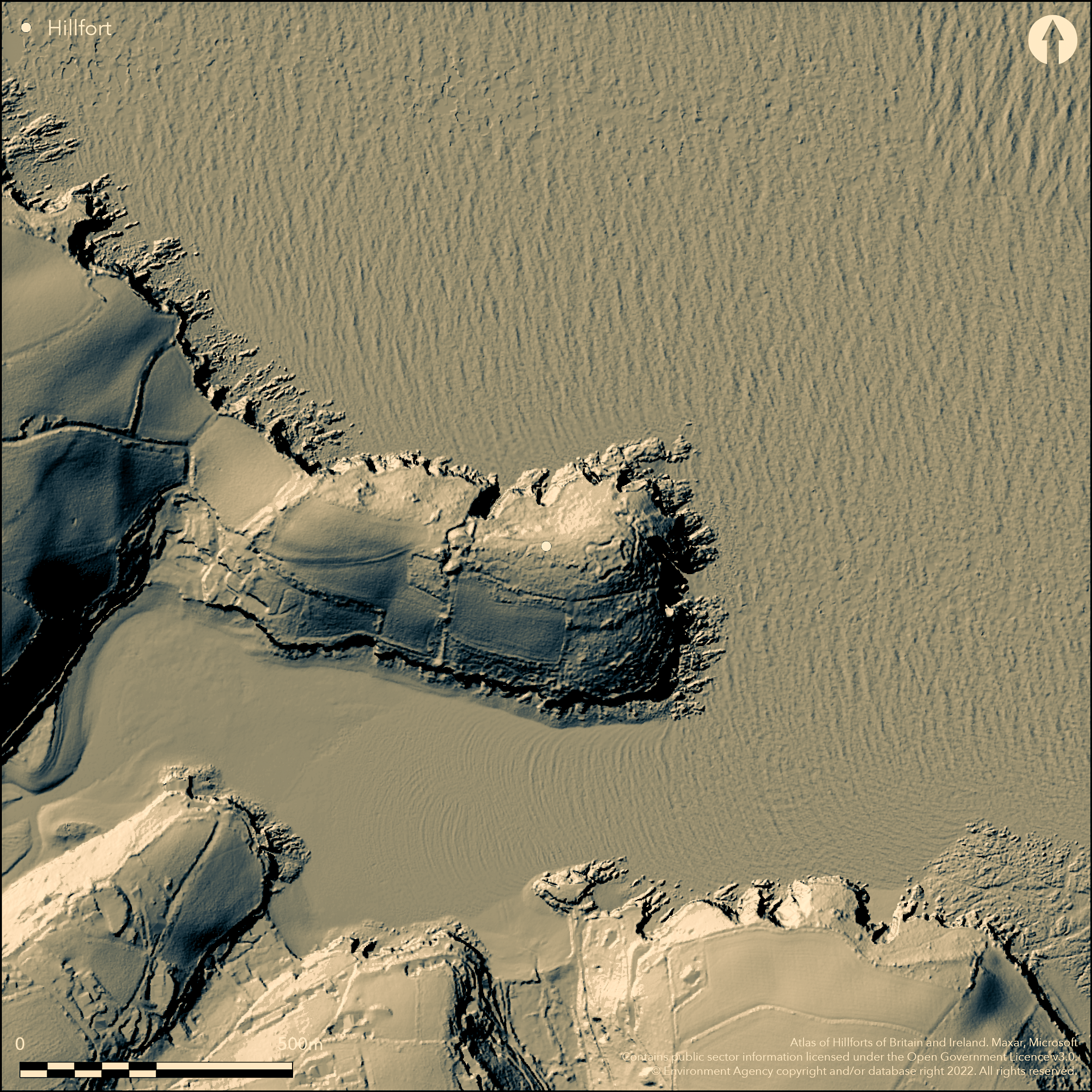
LiDAR 1m DTM Hillshade

Satellite Imagery
LiDAR 1m DTM Hillshade
Satellite Imagery
Scroll left/right to view further images.
HER: Cornwall and Scilly MCO6557 (24445)
NMR: SW 72 NE 4 (426909)
SM: 1004431
NGR: SW7872025660
X: 178720 Y: 25660 (OSGB36)
Part destroyed site of large promontory fort of c. 8.7ha located on NE part of E-facing Dennis Head on S shore of Helford River estuary, with Gillan Creek to S. The fort survives only as N end of a rampart, with outer rock-cut ditch, located towards centre of headland. This was W side of fort and N half of the interior. Contains Civil War earthworks. First recorded in 1610 as 'Dinas' and by W. Borlase in 1769 as an 'old vallum', probably Roman, stretching across neck of headland on W. Name is Cornish and contains the element 'dynas' meaning 'fort', which suggests the site of a promontory fort. Vyvyan in 1910, when describing the Civil War fort, said no traces remained of the earlier occupation. But Victoria County History described 'Little Dinas' as cliff castle, larger than usual, citing Borlase among others, with only vague reference to Civil War works. Reputed chapel shown on 1910 plan. Coastal grassland and bare rock. On 1st Ed. OS map (1879). Undated.
Citizen Science: ✗
Reliability of Data: Confirmed
Reliability of Interpretation: Confirmed
X: -567170 Y: 6461820 (EPSG: 3857)
Longitude: -5.0949738052006275 Latitude: 50.08967184714466 (EPSG:4326)
Country: England
Current County or Unitary Authority: Cornwall
Historic County: Cornwall
Current Parish/Community/Council/Townland: St Anthony-in-Meneage
Only part visible on N. On Heritage at Risk Register (2015).
| Extant | ✓ |
| Cropmark | ✗ |
| Likely Destroyed | ✓ |
Coastal grassland and bare rock. Civil War features.
| Woodland | ✗ |
| Commercial Forestry Plantation | ✗ |
| Parkland | ✗ |
| Pasture (Grazing) | ✗ |
| Arable | ✗ |
| Scrub/Bracken | ✗ |
| Bare Outcrop | ✗ |
| Heather/Moorland | ✗ |
| Heath | ✗ |
| Built-up | ✗ |
| Coastal Grassland | ✓ |
| Other | ✓ |
Part of site of promontory fort (aka cliff castle) of c. 8.7ha located on NE part of E-facing Dennis Head headland on S shore of Helford River estuary, with Gillan Creek to S.
| Contour Fort | ✗ |
| Partial Contour Fort | ✗ |
| Promontory Fort | ✓ |
| Hillslope Fort | ✗ |
| Level Terrain Fort | ✗ |
| Marsh Fort | ✗ |
| Multiple Enclosure Fort | ✗ |
Coastal headland and sea cliffs
| Hilltop | ✗ |
| Coastal Promontory | ✓ |
| Inland Promontory | ✗ |
| Valley Bottom | ✗ |
| Knoll/Hillock/Outcrop | ✗ |
| Ridge | ✗ |
| Cliff/Plateau-edge/Scarp | ✗ |
| Hillslope | ✗ |
| Lowland | ✗ |
| Spur | ✗ |
Dominant Topographic Feature: Coastal headland.
| North | ✗ |
| Northeast | ✗ |
| East | ✓ |
| Southeast | ✗ |
| South | ✗ |
| Southwest | ✗ |
| West | ✗ |
| Northwest | ✗ |
| Level | ✗ |
Altitude: 50.0m
N/A
None.
Reliability: D - None
| Pre 1200BC | ✗ |
| 1200BC - 800BC | ✗ |
| 800BC - 400BC | ✗ |
| 400BC - AD50 | ✗ |
| AD50 - AD400 | ✗ |
| AD400 - AD 800 | ✗ |
| Post AD800 | ✗ |
| Unknown | ✓ |
| Pre Hillfort: | None |
| Post Hillfort: | Within fort Civil War fieldworks, including roughly-square shaped fort with projecting bastions, battery to NE defined by banks and further protective ditches and outworks with projecting bastions to W. Civil War fortifications built by Royalists 1643-4 and surrendered to Parliament in 1646. Reputed chapel shown on 1910 plan. |
First recorded in 1610 as 'Dinas' and by W. Borlase 1769. On 1st Ed. OS map (1879). Plotted by NMP - no date.
| 1st Identified Written Reference (1610): | No details. |
| 1st Identified Map Depiction (1879): | OS map. |
| Other (None): | Mentioned by W. Borlase. |
| Other (None): | Plotted by NMP. |
None.
None
| None | ✓ |
| Spring | ✗ |
| Stream | ✗ |
| Pool | ✗ |
| Flush | ✗ |
| Well | ✗ |
| Other | ✗ |
None
| No Known Features | ✓ |
| Round Stone Structures | ✗ |
| Rectangular Stone Structures | ✗ |
| Curvilinear Platforms | ✗ |
| Other Roundhouse Evidence | ✗ |
| Pits | ✗ |
| Quarry Hollows | ✗ |
| Other | ✗ |
None
| No Known Excavation | ✓ |
| Pits | ✗ |
| Postholes | ✗ |
| Roundhouses | ✗ |
| Rectangular Structures | ✗ |
| Roads/Tracks | ✗ |
| Quarry Hollows | ✗ |
| Other | ✗ |
| Nothing Found | ✗ |
None
| No Known Geophysics | ✓ |
| Pits | ✗ |
| Roundhouses | ✗ |
| Rectangular Structures | ✗ |
| Roads/Tracks | ✗ |
| Quarry Hollows | ✗ |
| Other | ✗ |
| Nothing Found | ✗ |
None
| No Known Finds | ✓ |
| Pottery | ✗ |
| Metal | ✗ |
| Metalworking | ✗ |
| Human Bones | ✗ |
| Animal Bones | ✗ |
| Lithics | ✗ |
| Environmental | ✗ |
| Other | ✗ |
None
| APs Not Checked | ✓ |
| None | ✗ |
| Roundhouses | ✗ |
| Rectangular Structures | ✗ |
| Pits | ✗ |
| Postholes | ✗ |
| Roads/Tracks | ✗ |
| Other | ✗ |
None recorded.
| 0: | Not recorded. |
| 2: | None |
Guard Chambers: ✗
Chevaux de Frise: ✗
The fort survives only as N end of a rampart, with outer rock-cut ditch, located towards centre of headland. This was W side of fort and N half of the interior.
| Area 1: | 8.7ha. |
| Total: | 8.7ha. |
Total Footprint Area: Noneha.
None
| ✗ | None |
| ✗ | None |
| NE Quadrant: | 0 |
| SE Quadrant: | 0 |
| SW Quadrant: | 0 |
| NW Quadrant: | 1 |
| Total: | 1 |
| Partial Univallate | ✓ |
| Univallate | ✗ |
| Partial Bivallate | ✗ |
| Bivallate | ✗ |
| Partial Multivallate | ✗ |
| Multivallate | ✗ |
| Unknown | ✗ |
| Partial Univallate | ✗ |
| Univallate | ✗ |
| Partial Bivallate | ✗ |
| Bivallate | ✗ |
| Partial Multivallate | ✗ |
| Multivallate | ✗ |
None
| None | ✗ |
| Earthen Bank | ✓ |
| Stone Wall | ✗ |
| Rubble | ✗ |
| Wall-walk | ✗ |
| Evidence of Timber | ✗ |
| Vitrification | ✗ |
| Other Burning | ✗ |
| Palisade | ✗ |
| Counter Scarp Bank | ✗ |
| Berm | ✗ |
| Unfinished | ✗ |
| Other | ✗ |
None
| None | ✗ |
| Earthen Bank | ✗ |
| Stone Wall | ✗ |
| Murus Duplex | ✗ |
| Timber-framed | ✗ |
| Timber-laced | ✗ |
| Vitrification | ✗ |
| Other Burning | ✗ |
| Palisade | ✗ |
| Counter Scarp Bank | ✗ |
| Berm | ✗ |
| Unfinished | ✗ |
| No Known Excavation | ✓ |
| Other | ✗ |
| ✗ | None |
| ✓ | Outer rock-cut ditch. |
Number of Ditches: 1
| ✗ | None |
Borlase, W. 1754. Antiquities Historical and Monumental of the County of Cornwall, 290.
Borlase, W. 1769. The antiquities of Cornwall, London: W. Bowyer and J. Nichols, 312.
Cotton, M.A. 1958-9. Cornish Cliff Castles, Proc West Cornwall Fld Club, 2, 3, 119.
Page, W. ed. 1906. The Victoria History of the County of Cornwall, 1, London: James Street, 458.
Atlas of Hillforts:
Wikidata:
This work is licensed under CC BY-SA 4.0

 and should be cited as:
Lock, Gary and Ralston, Ian. 2024. Atlas of Hillforts of Britain and Ireland. Available at: https://hillforts.arch.ox.ac.uk
Document Version 1.1