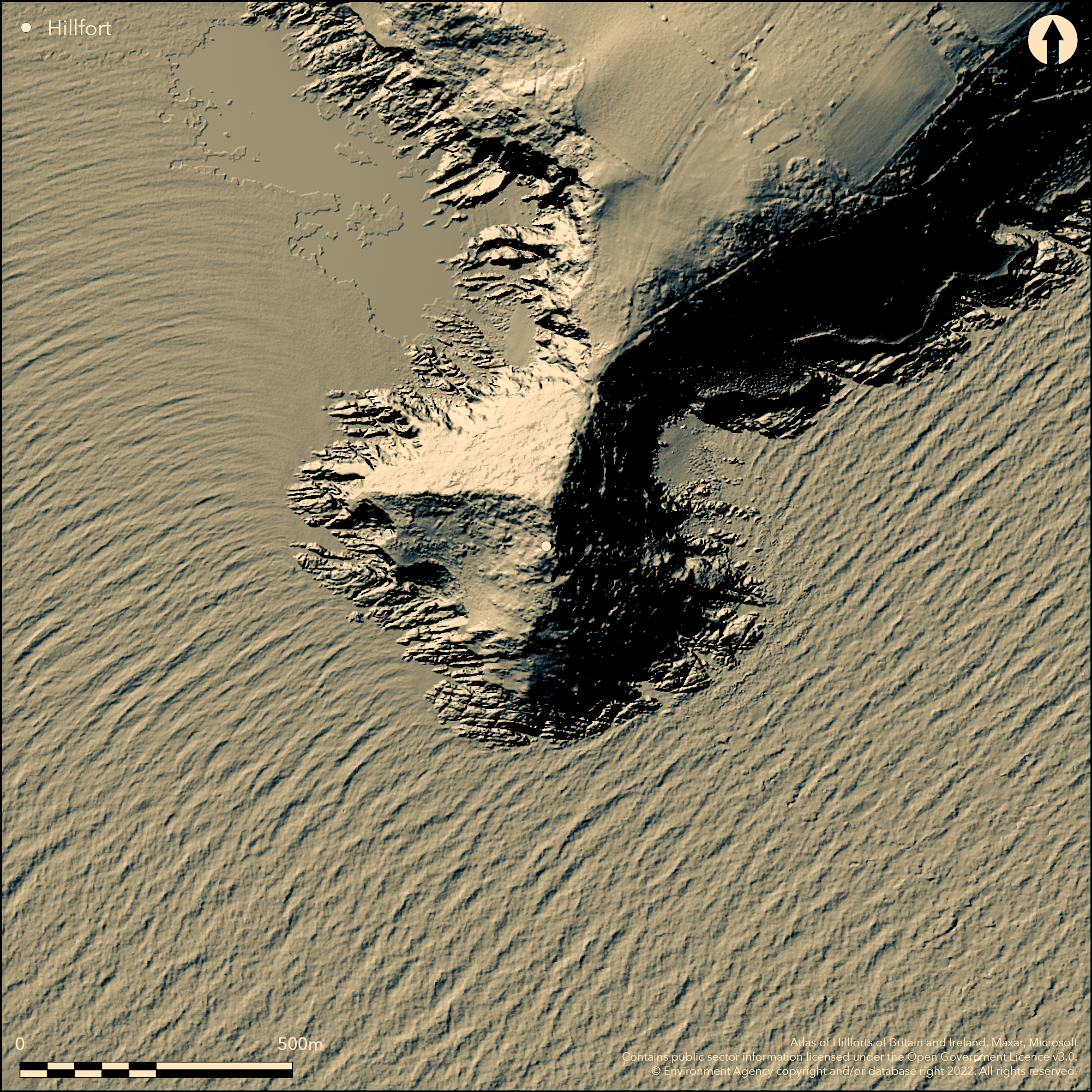
LiDAR 1m DTM Hillshade
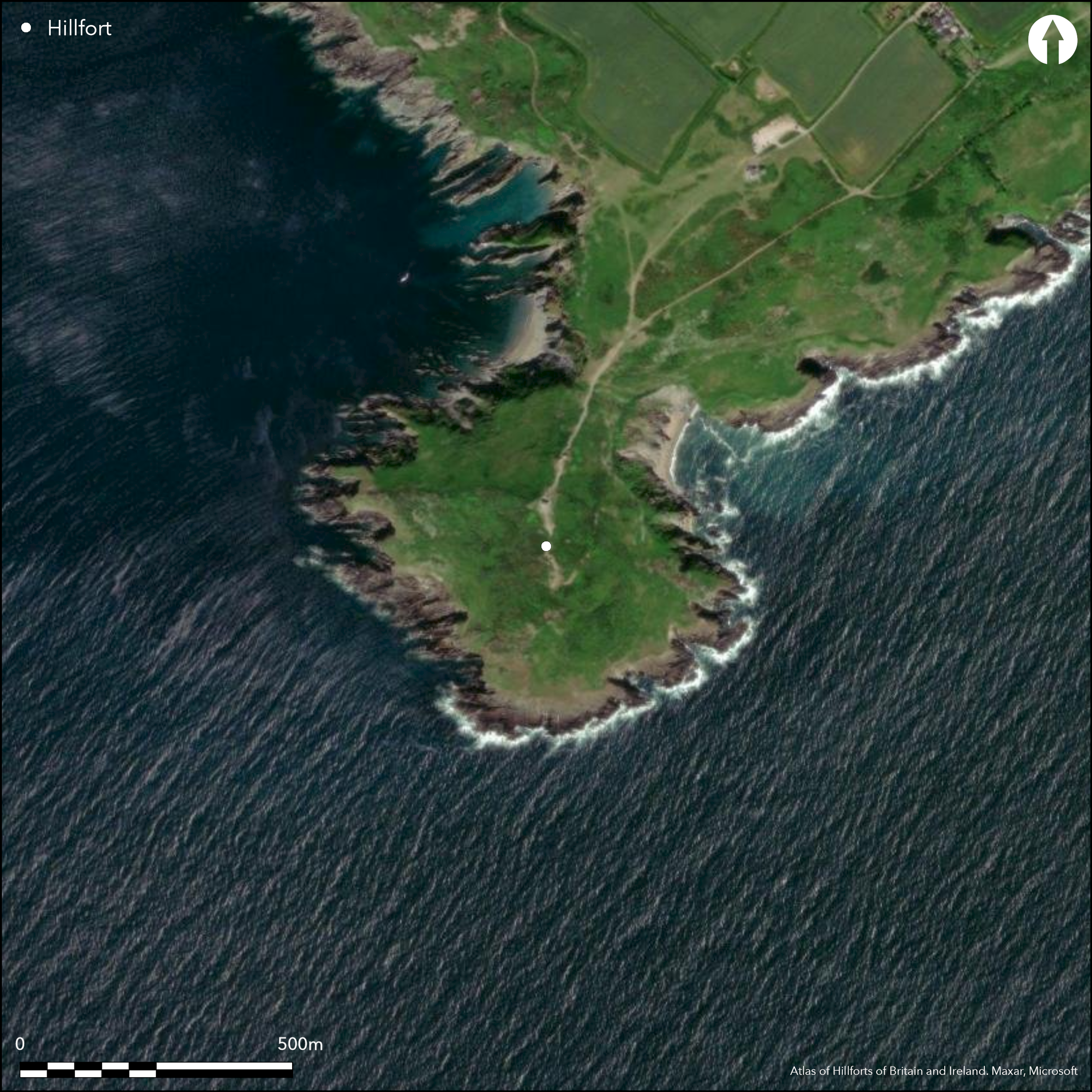
Satellite Imagery
LiDAR 1m DTM Hillshade
Satellite Imagery
Scroll left/right to view further images.
HER: Cornwall and Scilly MCO6570 (6000)
NMR: SW 44 NW 1 (437403)
SM: 1004510
NGR: SX418482
X: 241814 Y: 48292 (OSGB36)
Impressive and irregularly shaped promontory fort located on tip of SSW-facing rocky headland of Rame Head, dividing Cawsand Bay from Whitsand Bay and forming protective natural barrier on W side of Plymouth Sound. Steep sea cliffs on all but NE side where narrow neck of land connects site to mainland, and bank of earth and stone, varying from 6.5m to 9.5m, encloses c. 9ha. The ditch is 2m wide and well-defined. Central entrance. Ground rises to natural point within centre of fort and on summit is small rectangular, stone-built chapel measuring approximately 6.4m long by 3m wide, having with variety of later uses, and part of Royal Air Force WWII Chain Home Low radar station. The site is covered with bracken and rough coastal grass. Few investigations. On 1st Ed. OS map (1886). Undated.
Citizen Science: ✗
Reliability of Data: Confirmed
Reliability of Interpretation: Confirmed
X: -470120 Y: 6500698 (EPSG: 3857)
Longitude: -4.223158850708706 Latitude: 50.3132240699229 (EPSG:4326)
Country: England
Current County or Unitary Authority: Cornwall
Historic County: Cornwall
Current Parish/Community/Council/Townland: Maker-with-Rame
Rough grass and bracken. Variable condition with medieval chapel, measuring approximately 6.4m long by 3m wide, and part of Royal Air Force Chain Home Low radar station established at Rame Head in June 1940 to provide early warning of low flying enemy aircraft approaching Plymouth during the Second World War. Rampart bank partially built over by 20th century defensive structures. SSSI.
| Extant | ✓ |
| Cropmark | ✗ |
| Likely Destroyed | ✗ |
Bracken, rough coastal grass and bare rock with structures. Buildings.
| Woodland | ✗ |
| Commercial Forestry Plantation | ✗ |
| Parkland | ✗ |
| Pasture (Grazing) | ✗ |
| Arable | ✗ |
| Scrub/Bracken | ✓ |
| Bare Outcrop | ✗ |
| Heather/Moorland | ✗ |
| Heath | ✗ |
| Built-up | ✓ |
| Coastal Grassland | ✓ |
| Other | ✗ |
Promontory fort (aka cliff castle) located on tip of SSW-facing rocky headland of Rame Head, which divides Cawsand Bay from Whitsand Bay, forming protective natural barrier on the W side of Plymouth Sound. Steep sea cliffs on all but NE side where narrow neck of land connects site to mainland,
| Contour Fort | ✗ |
| Partial Contour Fort | ✗ |
| Promontory Fort | ✓ |
| Hillslope Fort | ✗ |
| Level Terrain Fort | ✗ |
| Marsh Fort | ✗ |
| Multiple Enclosure Fort | ✗ |
Bank cuts off the coastal headland at Rame Head bounded by sea cliffs
| Hilltop | ✗ |
| Coastal Promontory | ✓ |
| Inland Promontory | ✗ |
| Valley Bottom | ✗ |
| Knoll/Hillock/Outcrop | ✗ |
| Ridge | ✗ |
| Cliff/Plateau-edge/Scarp | ✗ |
| Hillslope | ✗ |
| Lowland | ✗ |
| Spur | ✗ |
Dominant Topographic Feature: Coastal headland
| North | ✗ |
| Northeast | ✗ |
| East | ✗ |
| Southeast | ✗ |
| South | ✗ |
| Southwest | ✓ |
| West | ✗ |
| Northwest | ✗ |
| Level | ✗ |
Altitude: 80.0m
N/A
None.
Reliability: D - None
| Pre 1200BC | ✗ |
| 1200BC - 800BC | ✗ |
| 800BC - 400BC | ✗ |
| 400BC - AD50 | ✗ |
| AD50 - AD400 | ✗ |
| AD400 - AD 800 | ✗ |
| Post AD800 | ✗ |
| Unknown | ✓ |
| Pre Hillfort: | None |
| Post Hillfort: | Medieval chapel and Royal Air Force WWII Chain Home Low radar station. |
On 1st Ed. OS map (1886). Some investigations in the 1980's - no details. Plotted by NMP - no date.
| 1st Identified Map Depiction (1886): | OS map. |
| Other (None): | Some investigations - no details. |
| Other (None): | Plotted by NMP. |
Several stray finds of flints have been made within the hillfort.
None
| None | ✓ |
| Spring | ✗ |
| Stream | ✗ |
| Pool | ✗ |
| Flush | ✗ |
| Well | ✗ |
| Other | ✗ |
None
| No Known Features | ✓ |
| Round Stone Structures | ✗ |
| Rectangular Stone Structures | ✗ |
| Curvilinear Platforms | ✗ |
| Other Roundhouse Evidence | ✗ |
| Pits | ✗ |
| Quarry Hollows | ✗ |
| Other | ✗ |
None
| No Known Excavation | ✓ |
| Pits | ✗ |
| Postholes | ✗ |
| Roundhouses | ✗ |
| Rectangular Structures | ✗ |
| Roads/Tracks | ✗ |
| Quarry Hollows | ✗ |
| Other | ✗ |
| Nothing Found | ✗ |
None
| No Known Geophysics | ✓ |
| Pits | ✗ |
| Roundhouses | ✗ |
| Rectangular Structures | ✗ |
| Roads/Tracks | ✗ |
| Quarry Hollows | ✗ |
| Other | ✗ |
| Nothing Found | ✗ |
Several stray finds of flints have been made within the hillfort.
| No Known Finds | ✗ |
| Pottery | ✗ |
| Metal | ✗ |
| Metalworking | ✗ |
| Human Bones | ✗ |
| Animal Bones | ✗ |
| Lithics | ✓ |
| Environmental | ✗ |
| Other | ✗ |
None
| APs Not Checked | ✓ |
| None | ✗ |
| Roundhouses | ✗ |
| Rectangular Structures | ✗ |
| Pits | ✗ |
| Postholes | ✗ |
| Roads/Tracks | ✗ |
| Other | ✗ |
Central entrance through rampart to NE.
| 1: | None |
| 2: | None |
Guard Chambers: ✗
Chevaux de Frise: ✗
| 1. Simple Gap (North east): | Central. |
Bank of earth and stone varies from 6.5m to 9.5m. Ditch is 2m wide and well-defined.
| Area 1: | 9.0ha. |
| Total: | 9.0ha. |
Total Footprint Area: Noneha.
None
| ✗ | None |
| ✗ | None |
| NE Quadrant: | 0 |
| SE Quadrant: | 1 |
| SW Quadrant: | 1 |
| NW Quadrant: | 0 |
| Total: | 1 |
| Partial Univallate | ✓ |
| Univallate | ✗ |
| Partial Bivallate | ✗ |
| Bivallate | ✗ |
| Partial Multivallate | ✗ |
| Multivallate | ✗ |
| Unknown | ✗ |
| Partial Univallate | ✗ |
| Univallate | ✗ |
| Partial Bivallate | ✗ |
| Bivallate | ✗ |
| Partial Multivallate | ✗ |
| Multivallate | ✗ |
Bank of earth and stone.
| None | ✗ |
| Earthen Bank | ✓ |
| Stone Wall | ✗ |
| Rubble | ✓ |
| Wall-walk | ✗ |
| Evidence of Timber | ✗ |
| Vitrification | ✗ |
| Other Burning | ✗ |
| Palisade | ✗ |
| Counter Scarp Bank | ✗ |
| Berm | ✗ |
| Unfinished | ✗ |
| Other | ✗ |
None
| None | ✗ |
| Earthen Bank | ✗ |
| Stone Wall | ✗ |
| Murus Duplex | ✗ |
| Timber-framed | ✗ |
| Timber-laced | ✗ |
| Vitrification | ✗ |
| Other Burning | ✗ |
| Palisade | ✗ |
| Counter Scarp Bank | ✗ |
| Berm | ✗ |
| Unfinished | ✗ |
| No Known Excavation | ✓ |
| Other | ✗ |
| ✗ | None |
| ✓ | The ditch is 2m wide and well-defined. |
Number of Ditches: 1
| ✗ | None |
Cotton, M.A. 1958-9. Cornish Cliff Castles, Proc West Cornwall Fld Club, 2, 3, 119.
Harris, G. and Fl, 1963. Essays and Notes on the Rame Peninsula, Unpublished MS At RIC, 357.
Henderson, C. 1914. Notebooks of Parochial Antiquities, Unpublished MS At RIC, 478.
Sheppard, P. 1974. PH checklist, Cornish Archaeol, 13, 73.
Atlas of Hillforts:
Wikidata:
This work is licensed under CC BY-SA 4.0

 and should be cited as:
Lock, Gary and Ralston, Ian. 2024. Atlas of Hillforts of Britain and Ireland. Available at: https://hillforts.arch.ox.ac.uk
Document Version 1.1