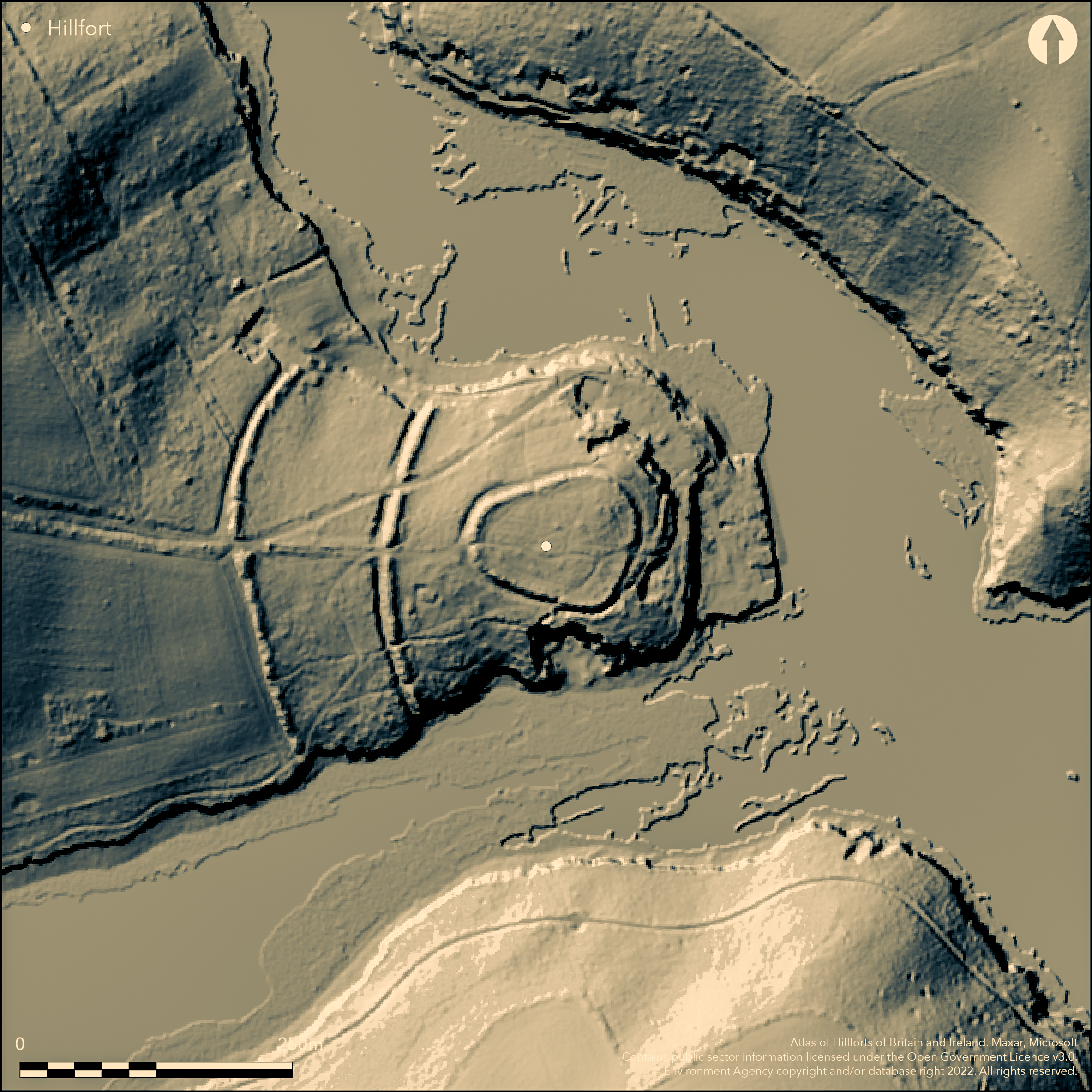
LiDAR 1m DTM Hillshade
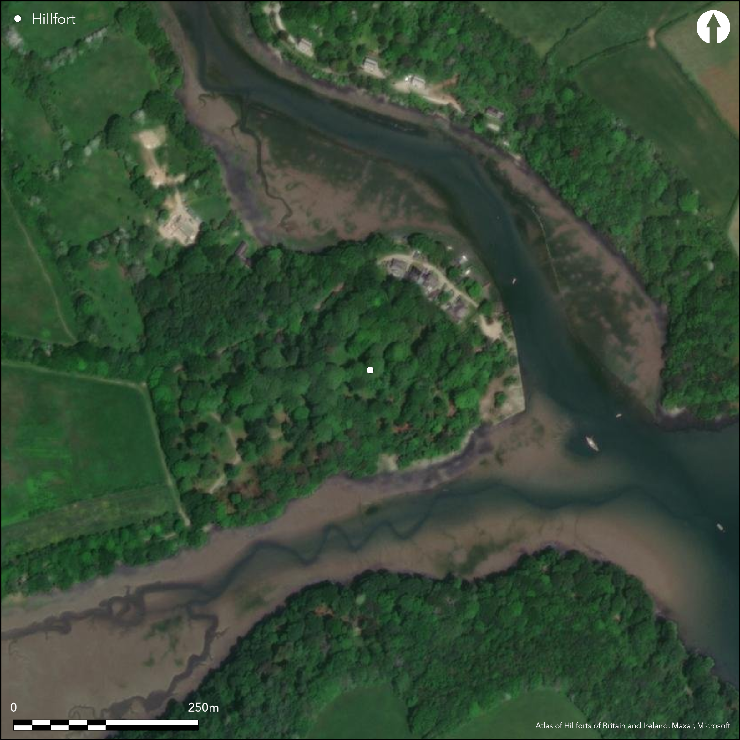
Satellite Imagery
LiDAR 1m DTM Hillshade
Satellite Imagery
Scroll left/right to view further images.
HER: Cornwall and Scilly MCO6574 (18864)
NMR: SW 84 SW 13 (428842)
SM: 1019847
NGR: SW83774039
X: 183770 Y: 40390 (OSGB36)
Multiple enclosure fort located on promontory at tidal confluence of Cowlands Creek and Lamouth Creek and River Fal, Feock. Measures c. 280m E-W to 230m N-S. Defined by two concentric curving earthworks cross neck of promontory to W side. Outer earthwork has, possibly revetted, rampart 5m wide and 1.5m high with no trace of ditch visible. Inner, and substantial, particularly at W end, earthwork lies c. 60m-70m E of outer line with rampart 7m-8m wide and 1.5m high with external ditch 3m wide at base, 7.8m wide at ground level and 1.4m deep. Within interior lies sub-oval enclosure rising to 1.2m (possibly a Romano British round) on level top of ridge. Three enclosed areas are 4.0ha, 2.5ha and 0.5ha. Original entrance to main enclosure at W centre with 5m wide causeway over ditch. Leats to supply water for industrial use visible around three sides of the promontory. Post Medieval boundary banks run along spine of promontory on W. N corner of small rectangular structure, possibly Post Medieval ornamental feature, visible on the SE side of fort. Late 18th/19th centuries track for copper ore and coal runs NE across fort to Round Wood Quay below. Site heavily wooded and affected by past industry and domestic buildings. On 1st Ed. OS map (1880). Undated.
Citizen Science: ✗
Reliability of Data: Confirmed
Reliability of Interpretation: Confirmed
X: -560254 Y: 6485129 (EPSG: 3857)
Longitude: -5.032842969434915 Latitude: 50.22382384391997 (EPSG:4326)
Country: England; None
Current County or Unitary Authority: Cornwall
Historic County: Cornwall
Current Parish/Community/Council/Townland: Feock; St. Michael Penkevil
Site and setting affected by past industry and domestic buldings. Leats to supply water for industrial use visible around three sides of the promontory. Post Medieval boundary banks run along spine of promontory on W. N corner of small rectangular structure, possibly Post Medieval ornamental feature, visible on the SE side of fort. Late 18th/19th centuries track for copper ore and coal runs NE across fort to Round Wood Quay with buildings below.
| Extant | ✓ |
| Cropmark | ✗ |
| Likely Destroyed | ✓ |
Heavily wooded. Buildings.
| Woodland | ✓ |
| Commercial Forestry Plantation | ✗ |
| Parkland | ✗ |
| Pasture (Grazing) | ✗ |
| Arable | ✗ |
| Scrub/Bracken | ✗ |
| Bare Outcrop | ✗ |
| Heather/Moorland | ✗ |
| Heath | ✗ |
| Built-up | ✓ |
| Coastal Grassland | ✗ |
| Other | ✓ |
Multiple enclosure promontory fort located on promontory at tidal confluence of Cowlands Creek, Lamouth Creek and River Fal, Feock.
| Contour Fort | ✗ |
| Partial Contour Fort | ✗ |
| Promontory Fort | ✓ |
| Hillslope Fort | ✗ |
| Level Terrain Fort | ✗ |
| Marsh Fort | ✗ |
| Multiple Enclosure Fort | ✓ |
Coastal headland location with sea cliffs
| Hilltop | ✗ |
| Coastal Promontory | ✗ |
| Inland Promontory | ✓ |
| Valley Bottom | ✗ |
| Knoll/Hillock/Outcrop | ✗ |
| Ridge | ✗ |
| Cliff/Plateau-edge/Scarp | ✗ |
| Hillslope | ✗ |
| Lowland | ✗ |
| Spur | ✗ |
Dominant Topographic Feature: Inland promontory.
| North | ✗ |
| Northeast | ✗ |
| East | ✗ |
| Southeast | ✗ |
| South | ✗ |
| Southwest | ✗ |
| West | ✗ |
| Northwest | ✗ |
| Level | ✓ |
Altitude: 18.0m
On parish boundary
Boundary Type: Parish/Townland
None.
Reliability: D - None
| Pre 1200BC | ✗ |
| 1200BC - 800BC | ✗ |
| 800BC - 400BC | ✗ |
| 400BC - AD50 | ✗ |
| AD50 - AD400 | ✗ |
| AD400 - AD 800 | ✗ |
| Post AD800 | ✗ |
| Unknown | ✓ |
| Pre Hillfort: | None |
| Post Hillfort: | Much 18th-19th century industrial developments. Watching Brief on land at Roundwood Cottage for monitoring extension groundworks recorded evidence for 18th century copper smelting. |
On 1st Ed. OS map (1880). Field investigation Ordnance Survey 1968. Survey HES 2004. Watching Brief on land at Roundwood Cottage for monitoring extension groundworks recorded evidence for 18th century copper smelting - Cornwall Archaeological Unit 2010.
| 1st Identified Map Depiction (1880): | OS map |
| Other (1968): | Field investigation OS. |
| Other (2004): | Survey HES. |
| Other (2010): | Watching brief Roundwood cottage. |
None.
None
| None | ✓ |
| Spring | ✗ |
| Stream | ✗ |
| Pool | ✗ |
| Flush | ✗ |
| Well | ✗ |
| Other | ✗ |
None
| No Known Features | ✓ |
| Round Stone Structures | ✗ |
| Rectangular Stone Structures | ✗ |
| Curvilinear Platforms | ✗ |
| Other Roundhouse Evidence | ✗ |
| Pits | ✗ |
| Quarry Hollows | ✗ |
| Other | ✗ |
None
| No Known Excavation | ✓ |
| Pits | ✗ |
| Postholes | ✗ |
| Roundhouses | ✗ |
| Rectangular Structures | ✗ |
| Roads/Tracks | ✗ |
| Quarry Hollows | ✗ |
| Other | ✗ |
| Nothing Found | ✗ |
None
| No Known Geophysics | ✓ |
| Pits | ✗ |
| Roundhouses | ✗ |
| Rectangular Structures | ✗ |
| Roads/Tracks | ✗ |
| Quarry Hollows | ✗ |
| Other | ✗ |
| Nothing Found | ✗ |
None
| No Known Finds | ✓ |
| Pottery | ✗ |
| Metal | ✗ |
| Metalworking | ✗ |
| Human Bones | ✗ |
| Animal Bones | ✗ |
| Lithics | ✗ |
| Environmental | ✗ |
| Other | ✗ |
None
| APs Not Checked | ✓ |
| None | ✗ |
| Roundhouses | ✗ |
| Rectangular Structures | ✗ |
| Pits | ✗ |
| Postholes | ✗ |
| Roads/Tracks | ✗ |
| Other | ✗ |
Original entrance to main enclosure at W centre with 5m wide causeway over ditch .
| 1: | None |
| 2: | None |
Guard Chambers: ✗
Chevaux de Frise: ✗
| 1. Simple Gap (West): | In centre of defences with causeway over ditch. |
Measuring 280m E-W to 230m N-S, two concentric curving earthworks cross neck of promontory to W side. Outer earthwork has, possibly revetted, rampart 5m wide and 1.5m high with no trace of ditch visible. Inner, and substantial, particularly at W end, earthwork lies c. 60m-70m E of outer defence with rampart 7m-8m wide and 1.5m high with external ditch 3m wide at base, 7.8m wide at ground level and 1.4m deep. Within interior lies sub-oval enclosure rising to 1.2m (possibly a Romano-British round) on level top of ridge.
| Area 1: | 0.5ha. |
| Area 2: | 2.5ha. |
| Area 3: | 4ha. |
| Total: | 4.0ha. |
Total Footprint Area: Noneha.
None
| ✗ | None |
| ✗ | None |
| NE Quadrant: | 0 |
| SE Quadrant: | 0 |
| SW Quadrant: | 2 |
| NW Quadrant: | 2 |
| Total: | 2 |
| Partial Univallate | ✗ |
| Univallate | ✗ |
| Partial Bivallate | ✓ |
| Bivallate | ✗ |
| Partial Multivallate | ✗ |
| Multivallate | ✗ |
| Unknown | ✗ |
| Partial Univallate | ✗ |
| Univallate | ✗ |
| Partial Bivallate | ✗ |
| Bivallate | ✗ |
| Partial Multivallate | ✗ |
| Multivallate | ✗ |
Outer earthwork possibly revetted.
| None | ✗ |
| Earthen Bank | ✓ |
| Stone Wall | ✓ |
| Rubble | ✗ |
| Wall-walk | ✗ |
| Evidence of Timber | ✗ |
| Vitrification | ✗ |
| Other Burning | ✗ |
| Palisade | ✗ |
| Counter Scarp Bank | ✗ |
| Berm | ✗ |
| Unfinished | ✗ |
| Other | ✗ |
None
| None | ✗ |
| Earthen Bank | ✗ |
| Stone Wall | ✗ |
| Murus Duplex | ✗ |
| Timber-framed | ✗ |
| Timber-laced | ✗ |
| Vitrification | ✗ |
| Other Burning | ✗ |
| Palisade | ✗ |
| Counter Scarp Bank | ✗ |
| Berm | ✗ |
| Unfinished | ✗ |
| No Known Excavation | ✓ |
| Other | ✗ |
| ✗ | None |
| ✓ | Ditch to inner earthwork. |
Number of Ditches: 1
| ✗ | None |
Kirkham, G. 2005. Roundwood Quay, Feock, Cornwall, Unpublished report HES.
Page, W. ed. 1906. The Victoria History of the County of Cornwall, 1, London: James Street, 465, 462.
Parkes, C. 2010. Roundwood Cottage, Cornwall: archaeological watching brief, Cornwall Archaeological Unit Report No 10R054, Cornwall County Council.
Atlas of Hillforts:
Wikidata:
This work is licensed under CC BY-SA 4.0

 and should be cited as:
Lock, Gary and Ralston, Ian. 2024. Atlas of Hillforts of Britain and Ireland. Available at: https://hillforts.arch.ox.ac.uk
Document Version 1.1