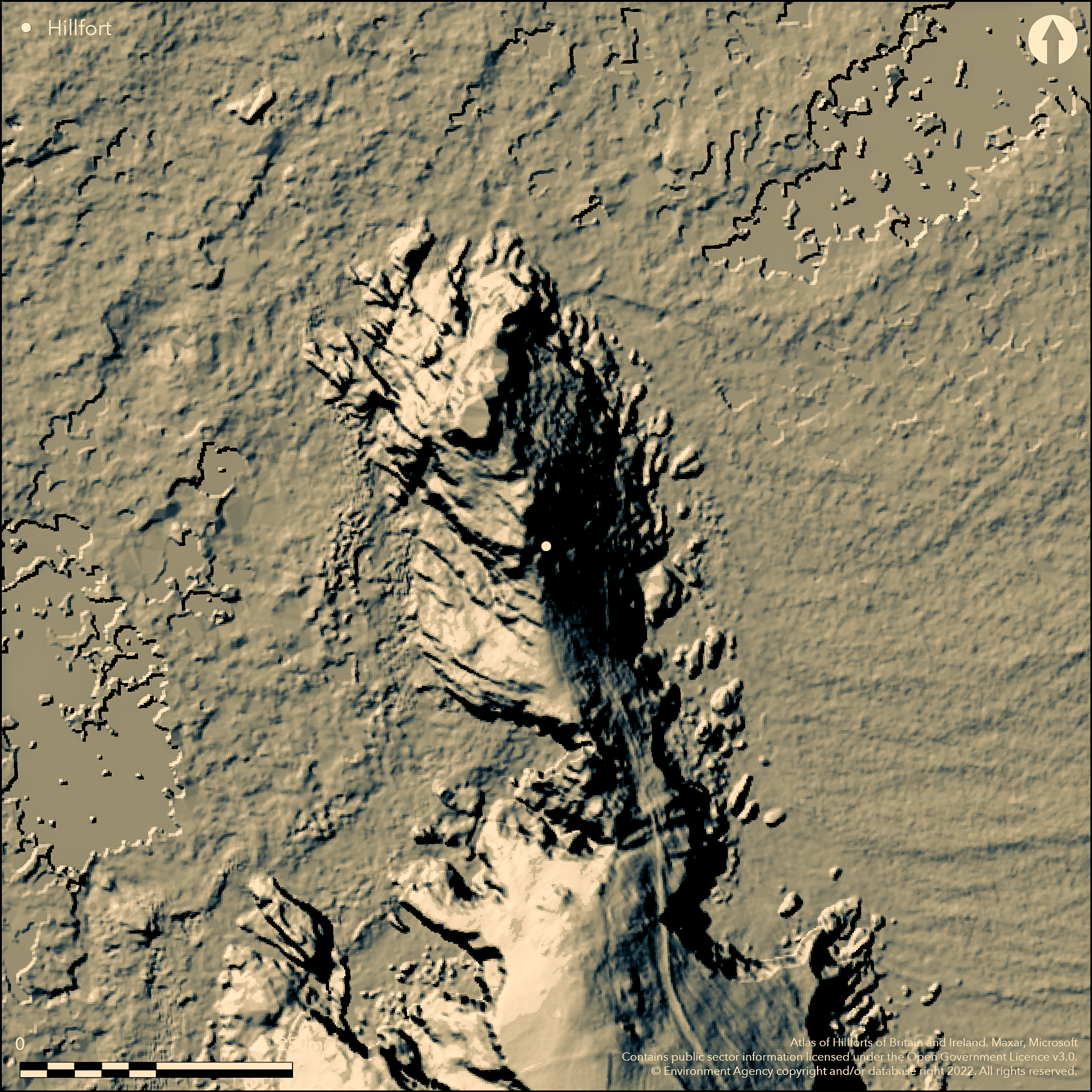
LiDAR 1m DTM Hillshade
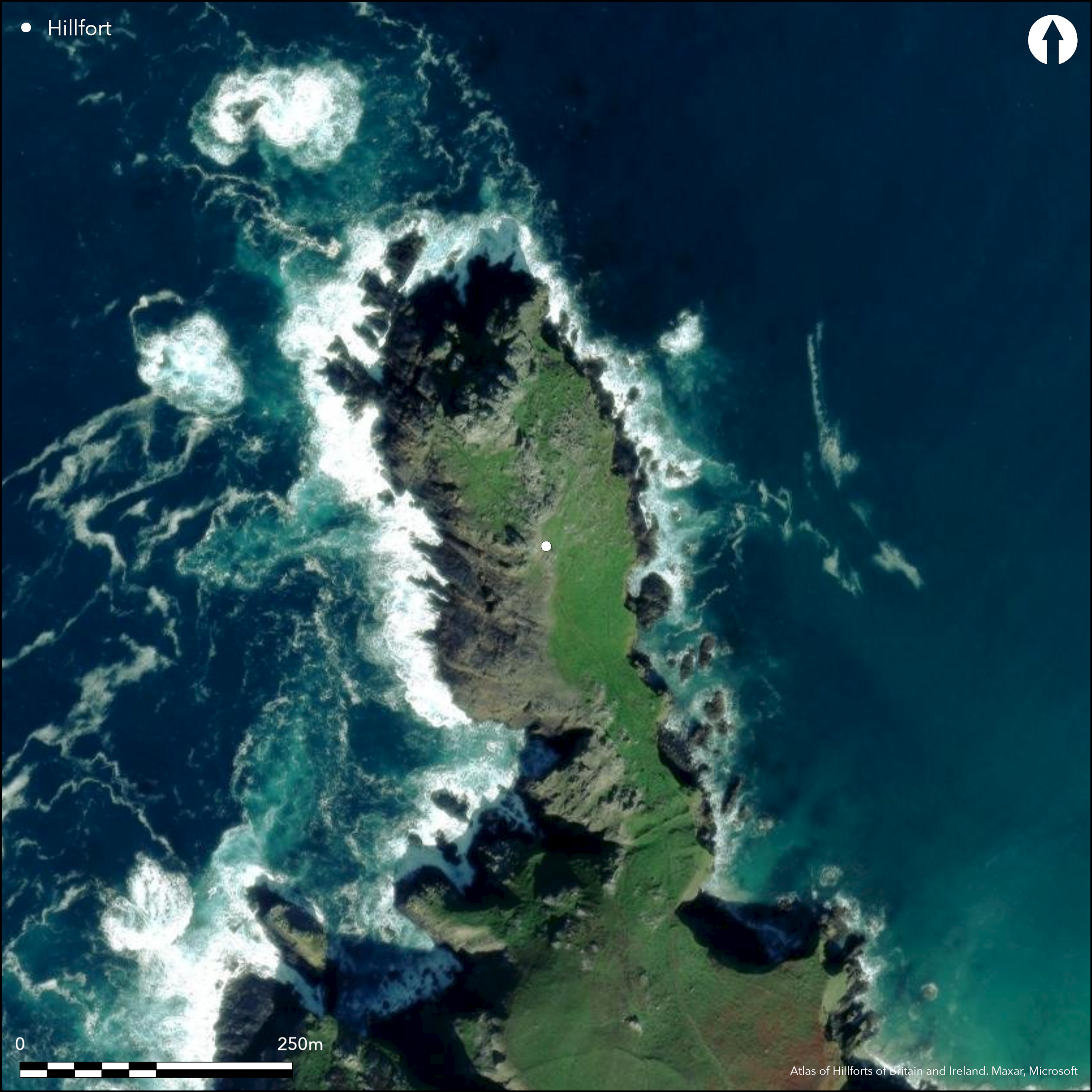
Satellite Imagery
LiDAR 1m DTM Hillshade
Satellite Imagery
Scroll left/right to view further images.
HER: Cornwall and Scilly MCO6582 (30838)
NMR: SW 43 NW 2 (423548)
SM: 1004300
NGR: SW43233865
X: 143230 Y: 38650 (OSGB36)
Promontory fort cutting off the N-facing Gurnard's Head at narrowest point using natural stone outcrops and enclosing 3ha. Steep sea cliffs to all but S. Inner rampart dry-stone construction to c. 2m wide and 1.8m high, but much fallen stone, suggesting considerably higher, and carefully built (not coursed) on inner side in three steps with wide ditch cut into the nearly 1m of soil overlying bedrock. Second bank to 0.7m high, with outer ditch, formed from spoil from the two ditches, capped by recent field wall, but has no stonework in construction. After some 11m on E side, only further partial outer ditch to 2.7m wide and 1.2m deep, but no backing third rampart. Original entrance to S now filled up and not visible on surface, although modern path now runs over it. At least 16 hut platforms identified on E-facing interior slopes, now be seen as shallow scoops 6.1m-9.1m in diameter, some with natural boulders within perimeter. Seven now on cliff edge due to coastal erosion. Partially excavated in April 1939 by A.S.R. Gordon. Two hut sites, one partly fallen over cliff, and part third investigated. Few small finds, including fragments of iron knife (domestic) iron buckle, spindle whorls, rubbing stone and pottery sherds. Third hut produced only medieval horseshoe. Of two small sherds found in ditches, one resembles the local Iron Age pottery in texture. Dating material absent from rampart cutting and close dating of site not possible, but existing evidence indicates date before middle 2nd century BC. On N tip of headland concrete base of 20th century lookout platform. Good coastal grassland and bare rock. Coastal erosion affecting site features and setting. On 1st Ed. OS map (1877).
Citizen Science: ✗
Reliability of Data: Confirmed
Reliability of Interpretation: Confirmed
X: -623270 Y: 6479593 (EPSG: 3857)
Longitude: -5.598927631257733 Latitude: 50.191996907920526 (EPSG:4326)
Country: England
Current County or Unitary Authority: Cornwall
Historic County: Cornwall
Current Parish/Community/Council/Townland: Zennor
Fallen stone, with coastal erosion affecting features and setting. At least seven hut platforms now on cliff edge. On N tip of headland concrete base of 20th century lookout platform.
| Extant | ✓ |
| Cropmark | ✗ |
| Likely Destroyed | ✗ |
Coastal grassland and bare rock. Lookout platform.
| Woodland | ✗ |
| Commercial Forestry Plantation | ✗ |
| Parkland | ✗ |
| Pasture (Grazing) | ✗ |
| Arable | ✗ |
| Scrub/Bracken | ✗ |
| Bare Outcrop | ✗ |
| Heather/Moorland | ✗ |
| Heath | ✗ |
| Built-up | ✗ |
| Coastal Grassland | ✓ |
| Other | ✓ |
Excavated promontory fort (aka cliff castle) cutting off the N-facing Gurnard's Head at its narrowest point making much use of natural stone outcrops. Steep sea cliffs to all but S side.
| Contour Fort | ✗ |
| Partial Contour Fort | ✗ |
| Promontory Fort | ✓ |
| Hillslope Fort | ✗ |
| Level Terrain Fort | ✗ |
| Marsh Fort | ✗ |
| Multiple Enclosure Fort | ✗ |
Coastal headland location with sea cliffs
| Hilltop | ✗ |
| Coastal Promontory | ✓ |
| Inland Promontory | ✗ |
| Valley Bottom | ✗ |
| Knoll/Hillock/Outcrop | ✗ |
| Ridge | ✗ |
| Cliff/Plateau-edge/Scarp | ✗ |
| Hillslope | ✗ |
| Lowland | ✗ |
| Spur | ✗ |
Dominant Topographic Feature: N-facing coastal promontory.
| North | ✓ |
| Northeast | ✗ |
| East | ✗ |
| Southeast | ✗ |
| South | ✗ |
| Southwest | ✗ |
| West | ✗ |
| Northwest | ✗ |
| Level | ✗ |
Altitude: 67.0m
N/A
Dating material was absent from the rampart cutting and close dating of site not possible, but existing pottery evidence indicates date before rather than after the middle of 2nd century B.C. Of two small sherds found in ditches, one resembles the local Iron Age pottery in texture.
Reliability: B - Medium
| Pre 1200BC | ✗ |
| 1200BC - 800BC | ✗ |
| 800BC - 400BC | ✗ |
| 400BC - AD50 | ✓ |
| AD50 - AD400 | ✗ |
| AD400 - AD 800 | ✗ |
| Post AD800 | ✗ |
| Unknown | ✗ |
| Pre Hillfort: | None |
| Post Hillfort: | None |
| Artefactual: | Of two small sherds found in ditches, one resembles the local Iron Age pottery in texture. |
Noted by R. Edmunds 1857. On 1st Ed. OS map (1877). Partially excavated April 1939 under the direction of Miss A.S.R. Gordon assisted by Cornwall Field Club. Field investigations Ordnance Survey 1961, 1975. Surveyed by National Trust 1987.
| 1st Identified Written Reference (1857): | Noted by R. Edmunds. |
| 1st Identified Map Depiction (1877): | OS map. |
| Excavation (1939): | Partially excavated in April 1939 under the direction of Miss A.S.R. Gordon. |
| Other (1978): | Visit by Hillfort Study Group |
| Other (1987): | Surveyed by NT. |
| Other (None): | Field investigations OS. |
At least 16 hut platforms identified on E-facing interior slopes, now can be seen as shallow scoops 6.1m - 9.1m in diameter, some with natural boulders within their perimeter. Seven now on cliff edge due to coastal erosion. Fragments of iron knife (domestic) iron buckle, spindle whorls, rubbing stone and pottery sherds.
None
| None | ✓ |
| Spring | ✗ |
| Stream | ✗ |
| Pool | ✗ |
| Flush | ✗ |
| Well | ✗ |
| Other | ✗ |
At least 16 hut platforms identified on E-facing interior slopes and clustered in two groups.
| No Known Features | ✗ |
| Round Stone Structures | ✗ |
| Rectangular Stone Structures | ✗ |
| Curvilinear Platforms | ✓ |
| Other Roundhouse Evidence | ✗ |
| Pits | ✗ |
| Quarry Hollows | ✗ |
| Other | ✗ |
Two hut sites, one of which had partly fallen over the cliff, and part of third investigated.
| No Known Excavation | ✗ |
| Pits | ✗ |
| Postholes | ✗ |
| Roundhouses | ✓ |
| Rectangular Structures | ✗ |
| Roads/Tracks | ✗ |
| Quarry Hollows | ✗ |
| Other | ✗ |
| Nothing Found | ✗ |
None
| No Known Geophysics | ✓ |
| Pits | ✗ |
| Roundhouses | ✗ |
| Rectangular Structures | ✗ |
| Roads/Tracks | ✗ |
| Quarry Hollows | ✗ |
| Other | ✗ |
| Nothing Found | ✗ |
None
| No Known Finds | ✗ |
| Pottery | ✓ |
| Metal | ✓ |
| Metalworking | ✗ |
| Human Bones | ✗ |
| Animal Bones | ✗ |
| Lithics | ✗ |
| Environmental | ✗ |
| Other | ✓ |
None
| APs Not Checked | ✓ |
| None | ✗ |
| Roundhouses | ✗ |
| Rectangular Structures | ✗ |
| Pits | ✗ |
| Postholes | ✗ |
| Roads/Tracks | ✗ |
| Other | ✗ |
Original entrance to S now filled up and not visible on surface, although modern path now runs over it.
| 0: | Original entrance now filled in. |
| 2: | None |
Guard Chambers: ✗
Chevaux de Frise: ✗
| 1. Simple Gap (South): | Now filled in and not visible from surface. |
Inner rampart of dry-stone construction to c. 2m wide and 1.8m high, but much fallen stone, suggesting considerably higher, and carefully built (not coursed) on inner side in three steps with wide ditch cut into the c. nearly 1m of soil overlying bedrock. Second bank to 0.7m high, with outer ditch formed from spoil from the two ditches, is capped by more recent field wall, but has no stonework in its construction. After some 11m on E side only further partial outer ditch to 2.7m wide and 1.2m deep, but no backing third rampart.
| Area 1: | 3.0ha. |
| Total: | 3.0ha. |
Total Footprint Area: Noneha.
None
| ✗ | None |
| ✗ | Two ramparts cut off promontory. Coastal erosion affecting features. |
| NE Quadrant: | 0 |
| SE Quadrant: | 2 |
| SW Quadrant: | 2 |
| NW Quadrant: | 0 |
| Total: | 2 |
| Partial Univallate | ✗ |
| Univallate | ✗ |
| Partial Bivallate | ✓ |
| Bivallate | ✗ |
| Partial Multivallate | ✗ |
| Multivallate | ✗ |
| Unknown | ✗ |
| Partial Univallate | ✗ |
| Univallate | ✗ |
| Partial Bivallate | ✗ |
| Bivallate | ✗ |
| Partial Multivallate | ✗ |
| Multivallate | ✗ |
Inner rampart revetted and stepped.
| None | ✗ |
| Earthen Bank | ✓ |
| Stone Wall | ✓ |
| Rubble | ✗ |
| Wall-walk | ✗ |
| Evidence of Timber | ✗ |
| Vitrification | ✗ |
| Other Burning | ✗ |
| Palisade | ✗ |
| Counter Scarp Bank | ✗ |
| Berm | ✗ |
| Unfinished | ✗ |
| Other | ✗ |
Inner rampart of dry-stone construction and carefully built (not coursed) on inner side in three steps with wide ditch cut into the c. nearly 1m of soil overlying bedrock. Second rampart of earth.
| None | ✗ |
| Earthen Bank | ✓ |
| Stone Wall | ✓ |
| Murus Duplex | ✗ |
| Timber-framed | ✗ |
| Timber-laced | ✗ |
| Vitrification | ✗ |
| Other Burning | ✗ |
| Palisade | ✗ |
| Counter Scarp Bank | ✗ |
| Berm | ✗ |
| Unfinished | ✗ |
| No Known Excavation | ✗ |
| Other | ✗ |
| ✗ | None |
| ✓ | Two ditches on outer side of ramparts, with another c. 11m outside with no third rampart. |
Number of Ditches: 3
| ✗ | None |
Brown, I. 2009. Beacons in the landscape. The hillforts of England and Wales. Oxford: Windgather Press/ Oxbow Books.
Cotton, M.A. 1958-9. Cornish Cliff Castles, Proc West Cornwall Fld Club, 2, 3, 119.
Edmonds, R. 1857, Celtic Antiquities of the Land's End District.
Johnson, N. and Rose, P. 1982. Defended settlement in Cornwall - an illustrated discussion, In ed. D. Miles, The Romano-British countryside: Studies in rural settlement and economy, BAR Brit Ser 103, 151-207.
Gordon, A.S.R. 1940. The excavation of Gurnard's Head, an Iron Age cliff castle in western Cornwall, Archaeol J, 97, 96-111.
Nowakowski, J.A. 1987. Gurnard's Head, Zennor., West Penwith, National Trust West Penwith Archaeological Survey, Cornwall Archaeological Unit Report 1987R007.
Page, W. ed. 1906. The Victoria History of the County of Cornwall, 1, London: James Street, 455.
Atlas of Hillforts:
Wikidata:
This work is licensed under CC BY-SA 4.0

 and should be cited as:
Lock, Gary and Ralston, Ian. 2024. Atlas of Hillforts of Britain and Ireland. Available at: https://hillforts.arch.ox.ac.uk
Document Version 1.1