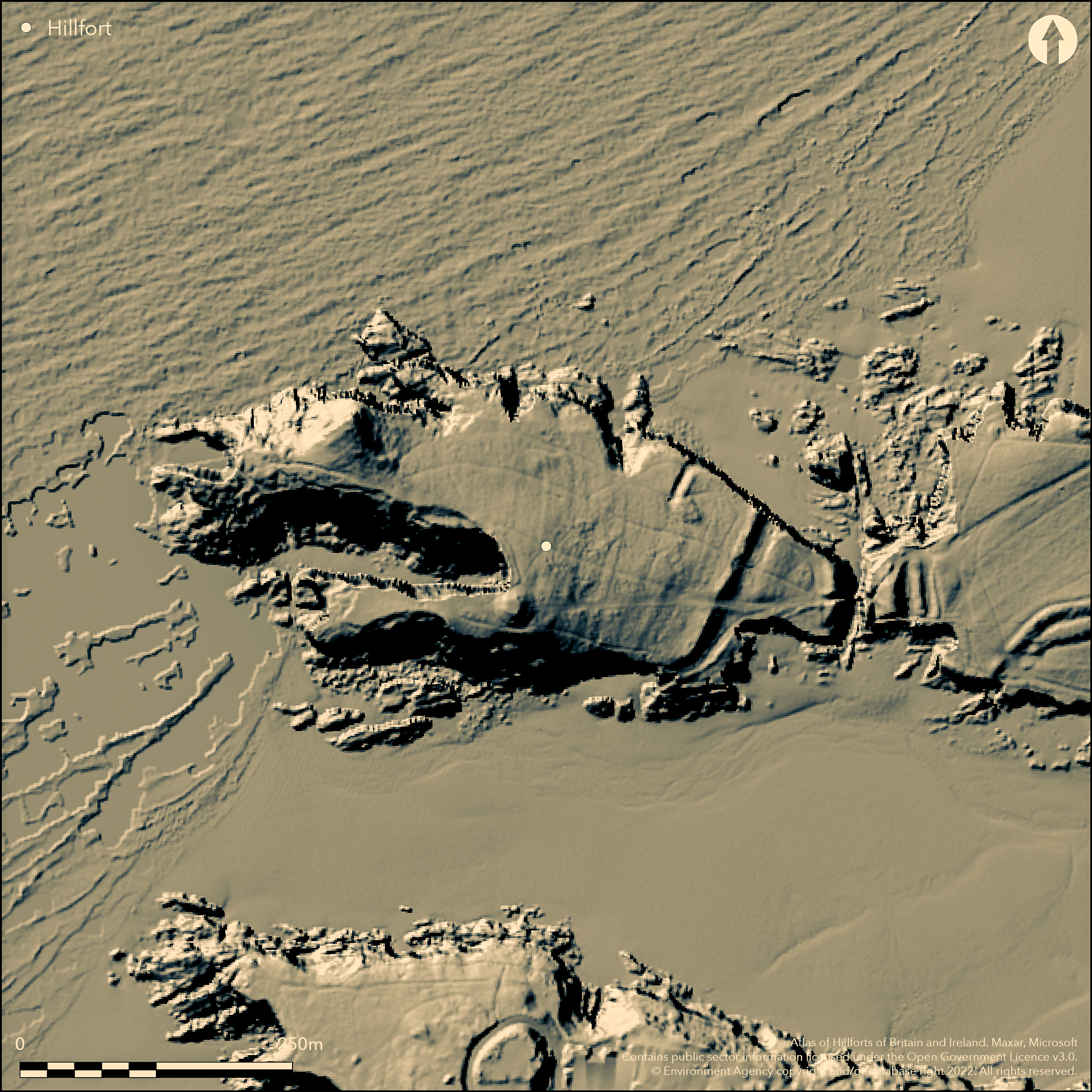
LiDAR 1m DTM Hillshade
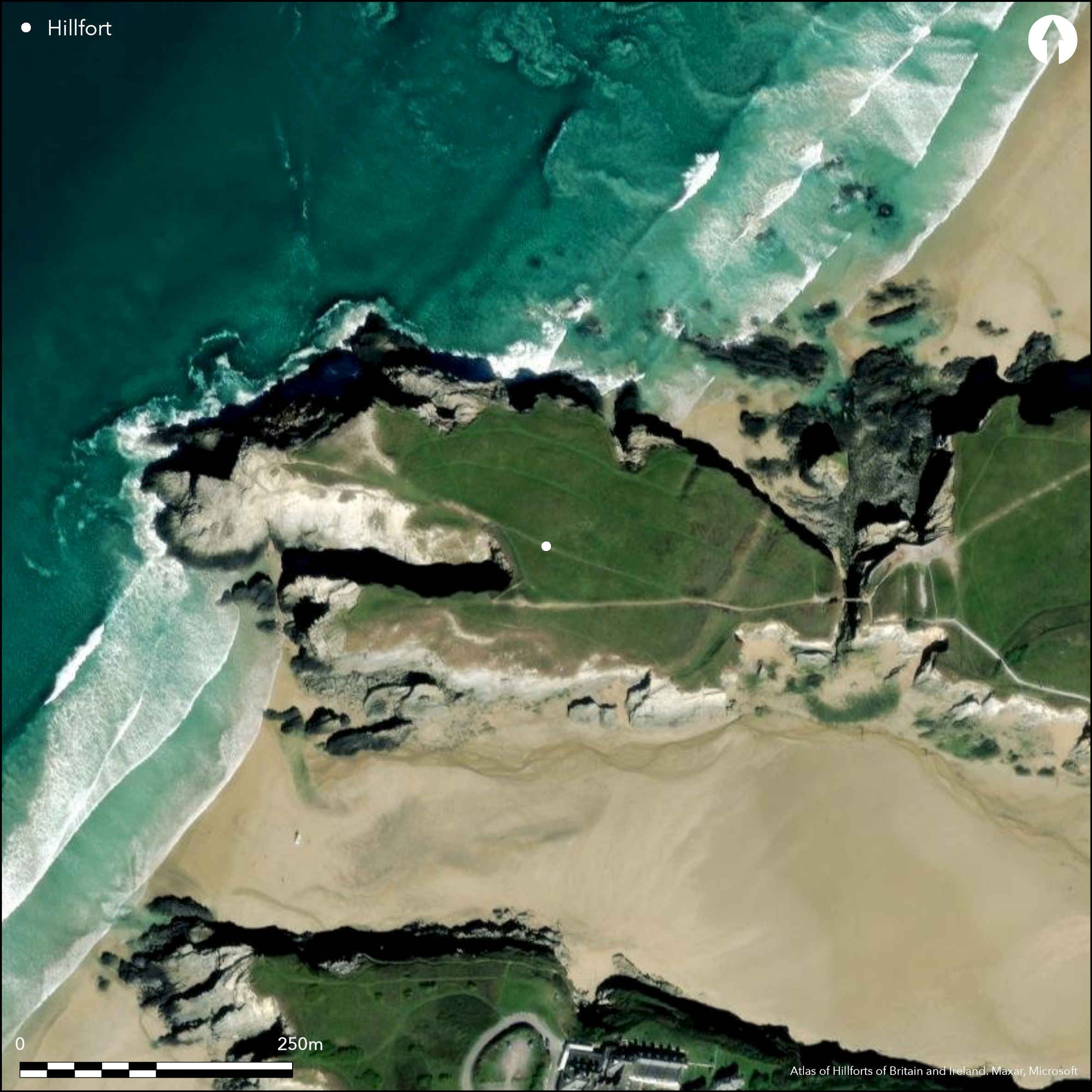
Satellite Imagery
LiDAR 1m DTM Hillshade
Satellite Imagery
Scroll left/right to view further images.
HER: Cornwall and Scilly MCO6584 (4127)
NMR: SW 86 SW 1 (429322)
SM: 1006712
NGR: SW8253063050
X: 182530 Y: 63050 (OSGB36)
Large and complex promontory fort on WNW-facing headland protecting the beaching cove of St Columb Porth (Porth Beach) to S and Whipsiderry Beach to N and between Newquay and Watergate Bays at Newquay. 700m long by 20m wide fort survives as coastal spur naturally defined on N and W by steep sea cliffs and S by cliffs to Porth Beach and landward to E by series of c. eight ramparts with ditches, including three outer ramparts landward comprising outer enclosure, possibly for grazing or cultivation; four middle banks across narrowest neck of headland and two further inner ramparts with smaller lengths of works around edges of headland where the cliffs are slightly lower. Encloses 3.2ha. Outermost ramparts closely-spaced, thus interior not overlooked. Four middle ramparts now separated by tidal chasm crossed by bridge and quarried for stone. Ramparts vary considerably in size and profile suggesting several phases of construction, although largest measures up to 12m wide, 4m high with 7m wide ditch. Partial excavations by Croft Andrew beginning in 1939, curtailed by WWII - no excavation report published, but subsequently by Cornwall Archaeological Unit (Nowakowski and Quinnell 2011). Good dating from 20 C14 dates and material culture. Activity from the Mesolithic through Roman period. A late Bronze Age/early Iron Age pit 8th century cal BC, early Iron Age phase 6th-4th centuries cal BC, main occupation phase middle Iron Age 400-100 cal BC. Two roundhouses excavated, earliest timber framed, later stone construction, also extensive midden deposits. The best example cleared was occupied in middle Iron Age, but in a second infilling some coins ranging from Claudius II to Theodosius I found. First Iron Age occupation defined by earth bank with palisade and ditch cutting off the promontory 6th-4th centuries cal BC, huts wooden framed with wattle and daub walls. Later in Iron Age two rows of substantial roundhouses built across headland inside innermost rampart. In interior traces of field system and numerous building platforms ranging. Metal mining, bronze and iron working carried out from the Iron Age with an iron mine to N side and evidence for bronze and iron smelting from furnaces and slag. Sea erosion cutting into site, otherwise good condition and coastal grassland and bare rock predominate. On 1st Ed. OS map (1881).
Citizen Science: ✗
Reliability of Data: Confirmed
Reliability of Interpretation: Confirmed
X: -563640 Y: 6520533 (EPSG: 3857)
Longitude: -5.063266575183247 Latitude: 50.42687084487039 (EPSG:4326)
Country: England
Current County or Unitary Authority: Cornwall
Historic County: Cornwall
Current Parish/Community/Council/Townland: Newquay
Sea erosion cutting into site, otherwise coastal grassland and ramparts in good order. On Heritage at Risk Register (2015).
| Extant | ✓ |
| Cropmark | ✗ |
| Likely Destroyed | ✗ |
Good coastal grassland and bare rock.
| Woodland | ✗ |
| Commercial Forestry Plantation | ✗ |
| Parkland | ✗ |
| Pasture (Grazing) | ✗ |
| Arable | ✗ |
| Scrub/Bracken | ✗ |
| Bare Outcrop | ✗ |
| Heather/Moorland | ✗ |
| Heath | ✗ |
| Built-up | ✗ |
| Coastal Grassland | ✓ |
| Other | ✗ |
Fine promontory fort (aka cliff castle) on WNW-facing headland protecting the beaching cove of St Columb Porth (Porth Beach) to S and Whipsiderry Beach to N and between Newquay and Watergate Bays at Newquay.
| Contour Fort | ✗ |
| Partial Contour Fort | ✗ |
| Promontory Fort | ✓ |
| Hillslope Fort | ✗ |
| Level Terrain Fort | ✗ |
| Marsh Fort | ✗ |
| Multiple Enclosure Fort | ✗ |
Sloping coastal east-west headland location with sea cliffs and protecting the beaching cove of St Columb Porth on the south
| Hilltop | ✗ |
| Coastal Promontory | ✓ |
| Inland Promontory | ✗ |
| Valley Bottom | ✗ |
| Knoll/Hillock/Outcrop | ✗ |
| Ridge | ✗ |
| Cliff/Plateau-edge/Scarp | ✗ |
| Hillslope | ✗ |
| Lowland | ✗ |
| Spur | ✗ |
Dominant Topographic Feature: Coastal headland.
| North | ✗ |
| Northeast | ✗ |
| East | ✗ |
| Southeast | ✓ |
| South | ✗ |
| Southwest | ✗ |
| West | ✗ |
| Northwest | ✗ |
| Level | ✗ |
Altitude: 32.0m
N/A
20 C14 dates plus material culture. Iron Age to Dark Age occupation as result of excavation - pit with LBA/EIA pottery 8th century cal BC, EIA phase 6th-4th centuries cal BC, main occupation middle IA 400-100 cal BC. Horn (Forthcoming) suggests the hillfort start 410-390 BC/410-360 BC, ends 170-10 BC. Occupation through Roman period. Some coins ranging from Claudius II to Theodosius I were found in infilling of hut with Dark Age dwelling finally placed over part.
Reliability: A - High
| Pre 1200BC | ✗ |
| 1200BC - 800BC | ✗ |
| 800BC - 400BC | ✓ |
| 400BC - AD50 | ✓ |
| AD50 - AD400 | ✓ |
| AD400 - AD 800 | ✗ |
| Post AD800 | ✗ |
| Unknown | ✗ |
| Pre Hillfort: | None |
| Post Hillfort: | None |
| Artefactual: | None |
| C14: | None |
On 1st Ed. OS map (1881). Excavated by Croft Andrew beginning in 1939, but recently evaluated by Cornwall Archaeological Unit. Measured survey English Heritage, CCRA 1983. Geophysical survey Ancient Monuments Laboratory 1983. Watching Brief Cornwall Archaeological Unit 2007. Plotted by NMP - no date.
| 1st Identified Map Depiction (1881): | OS map |
| Earthwork Survey (1983): | Measured survey EH, CCRA. |
| Geophysical Survey (1983): | Geophysical survey Ancient Monumants Laboratory - no report. |
| Other (2001): | Archive - Cornwall Archaeological Unit. |
| Other (2006): | Visited by Hillfort Study Group |
| Other (2007): | Watching Brief - Cornwall Archaeological Unit. |
| Excavation (None): | C.K.C. Andrew. |
| Other (None): | Plotted by NMP. |
Two roundhouses excavated, earliest timber framed, later stone construction. Traces of field system and numerous building platforms. Large range of material culture including pottery, metal and metal working, glass bead, animal bones and shellfish and Roman coins.
None
| None | ✓ |
| Spring | ✗ |
| Stream | ✓ |
| Pool | ✗ |
| Flush | ✗ |
| Well | ✗ |
| Other | ✗ |
Traces of field system and numerous building platforms ranging from 2nd century BC roundhouses to rectangular building dating to the 5th-6th century AD.
| No Known Features | ✗ |
| Round Stone Structures | ✗ |
| Rectangular Stone Structures | ✓ |
| Curvilinear Platforms | ✓ |
| Other Roundhouse Evidence | ✓ |
| Pits | ✗ |
| Quarry Hollows | ✗ |
| Other | ✓ |
Two roundhouses excavated, earliest timber framed with wattle and daub walls, the later stone construction. Extensive midden deposits.
| No Known Excavation | ✗ |
| Pits | ✓ |
| Postholes | ✓ |
| Roundhouses | ✓ |
| Rectangular Structures | ✗ |
| Roads/Tracks | ✗ |
| Quarry Hollows | ✗ |
| Other | ✓ |
| Nothing Found | ✗ |
No report on 1983 survey.
| No Known Geophysics | ✗ |
| Pits | ✗ |
| Roundhouses | ✗ |
| Rectangular Structures | ✗ |
| Roads/Tracks | ✗ |
| Quarry Hollows | ✗ |
| Other | ✓ |
| Nothing Found | ✗ |
Large range of material culture including pottery, significant evidence of metal and metal working, glass bead, animal bones and shellfish and Roman coins ranging from Claudius II to Theodosius I found. Wattle and daub. Extensive midden deposits.
| No Known Finds | ✗ |
| Pottery | ✓ |
| Metal | ✓ |
| Metalworking | ✓ |
| Human Bones | ✗ |
| Animal Bones | ✓ |
| Lithics | ✓ |
| Environmental | ✗ |
| Other | ✓ |
None
| APs Not Checked | ✓ |
| None | ✗ |
| Roundhouses | ✗ |
| Rectangular Structures | ✗ |
| Pits | ✗ |
| Postholes | ✗ |
| Roads/Tracks | ✗ |
| Other | ✗ |
Probable original offset entrance through middle of ramparts in SE.
| None: | Total gaps through ramparts not defined. |
| 2: | None |
Guard Chambers: ✗
Chevaux de Frise: ✗
| 1. Oblique (South east): | Probable offset entrance. |
Defined landward to E by series of c. eight ramparts with ditches, including three outer landward including outer enclosure, possibly for grazing or cultivation; four middle banks across narrowest neck of headland and two further inner banks with smaller lengths around edges of headland where the cliffs are slightly lower. Outermost ramparts closely spaced, thus interior not overlooked. Four middle ramparts now separated by tidal chasm crossed by bridge and quarried for stone. Ramparts vary considerably in size and profile suggesting several phases of construction, although largest measures to 12m wide, 4m high with 7m wide ditch.
| Area 1: | 3.2ha. |
| Total: | 3.2ha. |
Total Footprint Area: Noneha.
None
| ✓ | Ramparts vary considerably in size and profile suggesting several phases of construction. First Iron Age occupation defined by earth bank with palisade and ditch cutting off the promontory 6th-4th centuries cal BC. |
| ✗ | None |
| NE Quadrant: | 0 |
| SE Quadrant: | 8 |
| SW Quadrant: | 0 |
| NW Quadrant: | 0 |
| Total: | 8 |
| Partial Univallate | ✗ |
| Univallate | ✗ |
| Partial Bivallate | ✗ |
| Bivallate | ✗ |
| Partial Multivallate | ✓ |
| Multivallate | ✗ |
| Unknown | ✗ |
| Partial Univallate | ✗ |
| Univallate | ✓ |
| Partial Bivallate | ✗ |
| Bivallate | ✗ |
| Partial Multivallate | ✗ |
| Multivallate | ✗ |
None
| None | ✗ |
| Earthen Bank | ✓ |
| Stone Wall | ✗ |
| Rubble | ✓ |
| Wall-walk | ✗ |
| Evidence of Timber | ✗ |
| Vitrification | ✗ |
| Other Burning | ✗ |
| Palisade | ✗ |
| Counter Scarp Bank | ✗ |
| Berm | ✗ |
| Unfinished | ✗ |
| Other | ✗ |
First Iron Age occupation defined by earth bank with palisade and ditch cutting off the promontory 6th-4th centuries cal BC.
| None | ✗ |
| Earthen Bank | ✓ |
| Stone Wall | ✗ |
| Murus Duplex | ✗ |
| Timber-framed | ✗ |
| Timber-laced | ✗ |
| Vitrification | ✗ |
| Other Burning | ✗ |
| Palisade | ✓ |
| Counter Scarp Bank | ✗ |
| Berm | ✗ |
| Unfinished | ✗ |
| No Known Excavation | ✗ |
| Other | ✗ |
| ✗ | None |
| ✓ | Total estimated. |
Number of Ditches: 8
| ✗ | None |
Borlase, W.C. 1872. Exploration of Tumuli at Trevelgue, Archaeologia, 442, 423.
Catling, C. 2012. Shrines and smelting. Excavating Trevelgue Head. Current Archaeol, 267, 20-27.
Cotton, M.A. 1958-9. Cornish Cliff Castles, Proc West Cornwall Fld Club, 2, 3, 119.
Johnson, N. and Rose, P. 1982. Defended settlement in Cornwall - an illustrated discussion, In ed. D. Miles, The Romano-British countryside: Studies in rural settlement and economy, BAR Brit Ser 103, 151-207.
Page, W. ed. 1906. The Victoria History of the County of Cornwall, 1, London: James Street, 453.
Hammon A. 2005. The Iron age and Romano-British mammal and fish remains from Trevelgue Head Promontory Fort, Newquay, Cornwall, excavated in 1939 by C K Croft Andrew, Report No 3-2005, Centre for Archaeology.
Hencken, H.O. 1932. The Archaeology of Cornwall and Scilly, 124-125.
Horn, J. Forthcoming. The dating of hillforts in Britain and Ireland. Unpublished PhD thesis, University of Edinburgh.
Nowakowski, J.A. and Quinnell, H. 2011. Trevelgue head, Cornwall : the importance of CK Croft Andrew's 1939 excavations for prehistoric and Roman Cornwall. Cornwall : Cornwall Council.
Polsue, J. ed. 1867-72. Lake's Parochial History of Cornwall, Vol 1, 453.
Atlas of Hillforts:
Wikidata:
This work is licensed under CC BY-SA 4.0

 and should be cited as:
Lock, Gary and Ralston, Ian. 2024. Atlas of Hillforts of Britain and Ireland. Available at: https://hillforts.arch.ox.ac.uk
Document Version 1.1