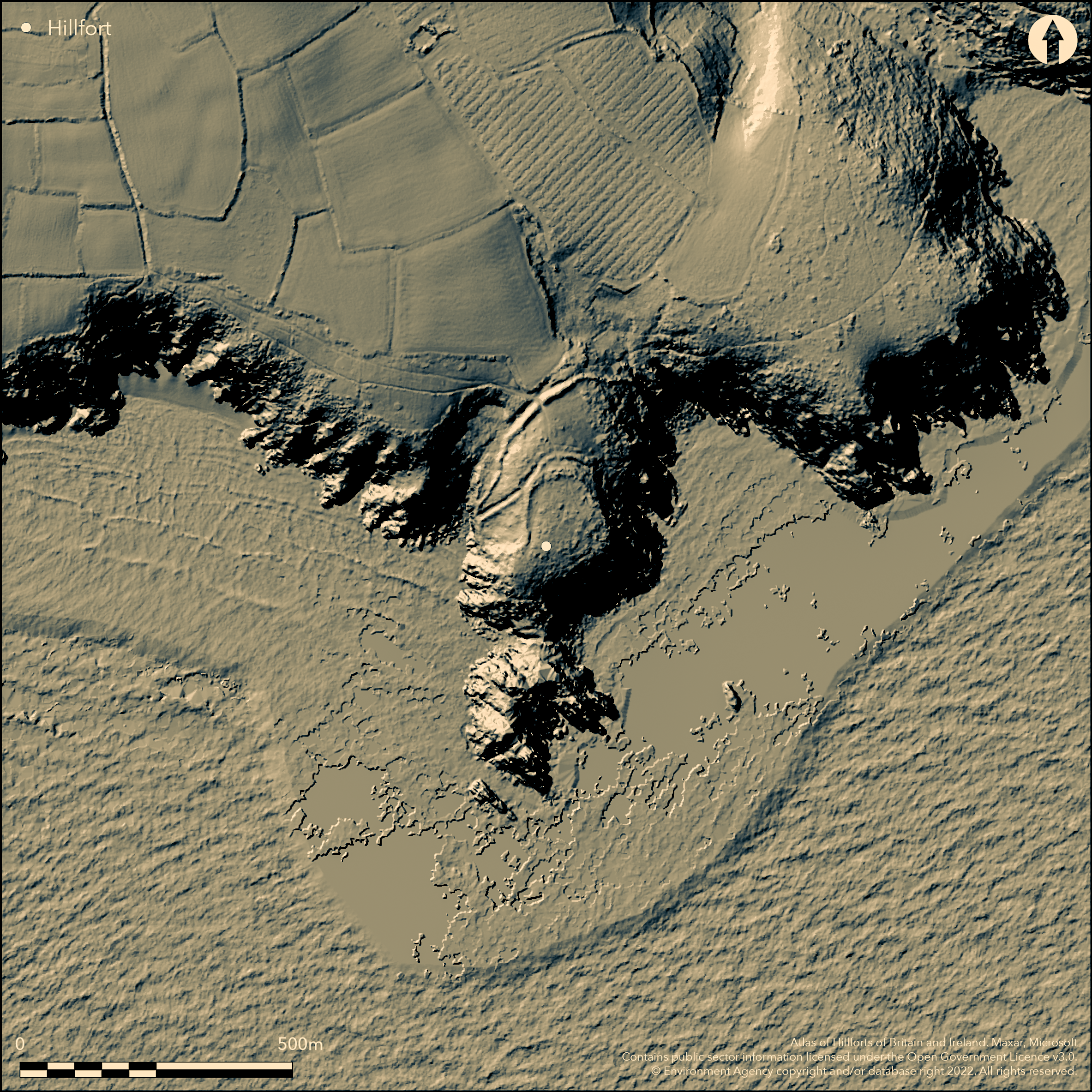
LiDAR 1m DTM Hillshade
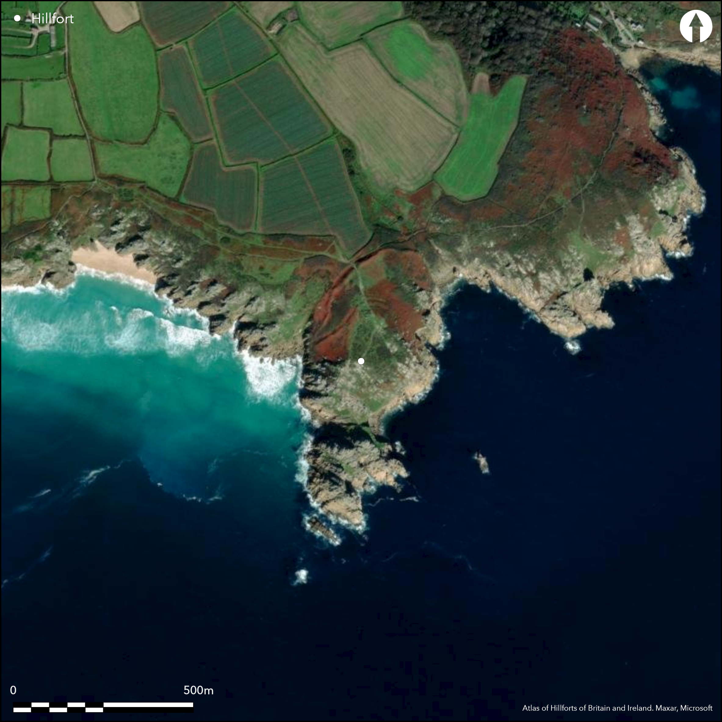
Satellite Imagery
LiDAR 1m DTM Hillshade
Satellite Imagery
Scroll left/right to view further images.
HER: Cornwall and Scilly MCO6583 (28291)
NMR: SW 32 SE 46 (421380)
SM: 1006733
NGR: SW39762218
X: 139760 Y: 22180 (OSGB36)
Promontory fort sited on small rocky granite S-facing headland known as Treryn, which has flat summit and slopes steeply to sea on E, S, and W. Polry and Barcastle Coves to W and Cripp's Cove to E cut into headland. Interior area 6ha. Three lines of ramparts on N landward side comprising four banks and ditches, other sides defined by sea cliffs. Innermost rampart extends across narrowest neck of headland, is simple bank and retaining wall, measuring to 2m high, composed of coursed stones with central inturned entrance with stone jambs. Distinct V-shaped ditch. Evidence of earlier rampart beneath innermost. Small enclosed area behind rampart contains two slightly oval hut platforms. Middle line of defence, 80m to S, consists of two curving ramparts, both relatively low rubble banks (inner robbed) with no facing stones, and outer ditch and counterscarp bank. To N, outer rampart high and well-preserved of earth and stone to 6.1m high, fading at extremities. Ditch also massive with simple causewayed entrance. To W of entrance, stone for rampart from inner quarry ditch to 9m wide. Possible hut circles in interior. Site also famous for its Logan or 'rocking' stone and first recorded by W. Borlase in the mid-18th century. Antiquarian reports of cist and possible stone circle within site now regarded as natural features or misinterpretations of construction techniques used. Flints and rubbing stone reported as surface finds since 19th century. Coastal grassland and bare rock. Sea erosion of headland. On 1st Ed. OS map (1878). Undated.
Citizen Science: ✗
Reliability of Data: Confirmed
Reliability of Interpretation: Confirmed
X: -627420 Y: 6453666 (EPSG: 3857)
Longitude: -5.636212966201528 Latitude: 50.04265358110198 (EPSG:4326)
Country: England
Current County or Unitary Authority: Cornwall
Historic County: Cornwall
Current Parish/Community/Council/Townland: St Levan
Sea erosion of headland and erosion and robbing of banks.
| Extant | ✓ |
| Cropmark | ✗ |
| Likely Destroyed | ✓ |
Coastal grassland and bare rock.
| Woodland | ✗ |
| Commercial Forestry Plantation | ✗ |
| Parkland | ✗ |
| Pasture (Grazing) | ✗ |
| Arable | ✗ |
| Scrub/Bracken | ✗ |
| Bare Outcrop | ✗ |
| Heather/Moorland | ✗ |
| Heath | ✗ |
| Built-up | ✗ |
| Coastal Grassland | ✓ |
| Other | ✗ |
Promontory fort (aka cliff castle) sited on a small rocky granite S-facing headland known as Treryn which has flat summit and slopes steeply to sea on E, S, and W. Polry and Barcastle Coves to W and Cripp's Cove to E cut into headland.
| Contour Fort | ✗ |
| Partial Contour Fort | ✗ |
| Promontory Fort | ✓ |
| Hillslope Fort | ✗ |
| Level Terrain Fort | ✗ |
| Marsh Fort | ✗ |
| Multiple Enclosure Fort | ✗ |
Located on a south facing rocky promontory with fairly flat grassy summit sloping to the sea on three sides
| Hilltop | ✗ |
| Coastal Promontory | ✓ |
| Inland Promontory | ✗ |
| Valley Bottom | ✗ |
| Knoll/Hillock/Outcrop | ✗ |
| Ridge | ✗ |
| Cliff/Plateau-edge/Scarp | ✗ |
| Hillslope | ✗ |
| Lowland | ✗ |
| Spur | ✗ |
Dominant Topographic Feature: Coastal headland
| North | ✗ |
| Northeast | ✗ |
| East | ✗ |
| Southeast | ✗ |
| South | ✓ |
| Southwest | ✗ |
| West | ✗ |
| Northwest | ✗ |
| Level | ✗ |
Altitude: 50.0m
N/A
None.
Reliability: D - None
| Pre 1200BC | ✗ |
| 1200BC - 800BC | ✗ |
| 800BC - 400BC | ✗ |
| 400BC - AD50 | ✗ |
| AD50 - AD400 | ✗ |
| AD400 - AD 800 | ✗ |
| Post AD800 | ✗ |
| Unknown | ✓ |
| Pre Hillfort: | Possible as Bronze Age finds. |
| Post Hillfort: | Possible as Roman finds. |
| Artefactual: | Chance finds. |
On 1st Ed. OS map (1878). First recorded by W. Borlase in mid-18th century. Named 'Trereen Castle' on 1813 Ordnance Survey map. Field investigation Ordnance Survey 1960. Conservation works and measured survey Cornwall Archaeological Unit, Cornwall County Council 1993, 1994. Management Survey National Trust 1997.
| 1st Identified Map Depiction (1878): | OS map. |
| Other (1960): | Field investigation OS. |
| Other (1993): | Conservation works CAU. |
| Earthwork Survey (1994): | Measured survey, CAU. |
| Other (1997): | Management Survey National Trust. |
| Other (2006): | Visited by Hillfort Study Group |
| 1st Identified Written Reference (None): | First recorded by W. Borlase. |
Small enclosed area behind inner rampart contains two slightly oval hut platforms. To the W of entrance, stone for rampart obtained from inner quarry ditch to 9m wide. Flints and a rubbing stone have been reported as surface finds since 19th century.
None
| None | ✓ |
| Spring | ✗ |
| Stream | ✗ |
| Pool | ✗ |
| Flush | ✗ |
| Well | ✗ |
| Other | ✗ |
Small enclosed area behind inner rampart contains two slightly oval hut platforms. To the W of entrance, stone for rampart obtained from inner quarry ditch to 9m wide.
| No Known Features | ✗ |
| Round Stone Structures | ✗ |
| Rectangular Stone Structures | ✗ |
| Curvilinear Platforms | ✓ |
| Other Roundhouse Evidence | ✗ |
| Pits | ✗ |
| Quarry Hollows | ✓ |
| Other | ✗ |
None
| No Known Excavation | ✓ |
| Pits | ✗ |
| Postholes | ✗ |
| Roundhouses | ✗ |
| Rectangular Structures | ✗ |
| Roads/Tracks | ✗ |
| Quarry Hollows | ✗ |
| Other | ✗ |
| Nothing Found | ✗ |
None
| No Known Geophysics | ✓ |
| Pits | ✗ |
| Roundhouses | ✗ |
| Rectangular Structures | ✗ |
| Roads/Tracks | ✗ |
| Quarry Hollows | ✗ |
| Other | ✗ |
| Nothing Found | ✗ |
Flints and a rubbing stone have been reported as surface finds since 19th century. Possible Roman coin found nearby.
| No Known Finds | ✗ |
| Pottery | ✗ |
| Metal | ✗ |
| Metalworking | ✗ |
| Human Bones | ✗ |
| Animal Bones | ✗ |
| Lithics | ✓ |
| Environmental | ✗ |
| Other | ✗ |
None
| APs Not Checked | ✓ |
| None | ✗ |
| Roundhouses | ✗ |
| Rectangular Structures | ✗ |
| Pits | ✗ |
| Postholes | ✗ |
| Roads/Tracks | ✗ |
| Other | ✗ |
Central inturned entrance with stone jambs to S innermost rampart. Simple causewayed central entrance to N outer rampart.
| 2: | None |
| 2: | None |
Guard Chambers: ✗
Chevaux de Frise: ✗
| 1. In-turned (South): | Central inturned entrance with stone jambs to S innermost rampart. |
| 2. Simple Gap (South): | Simple causewayed central entrance to N outer rampart. |
Three lines of ramparts on N landward side, comprising four banks and ditches, other sides defended by sea cliffs. Innermost rampart extends across narrowest neck of headland, is simple bank and retaining wall, measuring to 2m high, composed of coursed stones with central inturned entrance with stone jambs. Distinct V-shaped ditch. Middle line of defence, 80m to S, consists of two curving ramparts, both relatively low rubble banks (inner robbed) with no facing stones, and outer ditch and counterscarp bank. N, outer rampart high and well-preserved of earth and stone to 6.1m high, fading at extremities. Ditch also massive.
| Area 1: | 6.0ha. |
| Total: | 6.0ha. |
Total Footprint Area: Noneha.
None
| ✗ | None |
| ✗ | None |
| NE Quadrant: | 4 |
| SE Quadrant: | 0 |
| SW Quadrant: | 0 |
| NW Quadrant: | 4 |
| Total: | 4 |
| Partial Univallate | ✗ |
| Univallate | ✗ |
| Partial Bivallate | ✗ |
| Bivallate | ✗ |
| Partial Multivallate | ✓ |
| Multivallate | ✗ |
| Unknown | ✗ |
| Partial Univallate | ✗ |
| Univallate | ✗ |
| Partial Bivallate | ✗ |
| Bivallate | ✗ |
| Partial Multivallate | ✗ |
| Multivallate | ✗ |
Rubble and earth and stone banks.
| None | ✗ |
| Earthen Bank | ✓ |
| Stone Wall | ✓ |
| Rubble | ✓ |
| Wall-walk | ✗ |
| Evidence of Timber | ✗ |
| Vitrification | ✗ |
| Other Burning | ✗ |
| Palisade | ✗ |
| Counter Scarp Bank | ✓ |
| Berm | ✗ |
| Unfinished | ✗ |
| Other | ✗ |
None
| None | ✗ |
| Earthen Bank | ✗ |
| Stone Wall | ✗ |
| Murus Duplex | ✗ |
| Timber-framed | ✗ |
| Timber-laced | ✗ |
| Vitrification | ✗ |
| Other Burning | ✗ |
| Palisade | ✗ |
| Counter Scarp Bank | ✗ |
| Berm | ✗ |
| Unfinished | ✗ |
| No Known Excavation | ✓ |
| Other | ✗ |
| ✗ | None |
| ✓ | Distinct V-shaped ditch to inner rampart. Outer ditch massive to N. |
Number of Ditches: 4
| ✗ | None |
Borlase, W. 1754. Antiquities Historical and Monumental of the County of Cornwall, 180, 344, 351.
Blight, J.T. 1862. List of Antiquities in the Hundreds of Kerrier and Penwith.
Cotton, M.A. 1958-9. Cornish Cliff Castles, Proc West Cornwall Fld Club, 2, 3, 119.
Herring P. 1994. Repairs to Treryn Dinas Cliff Castle, St Levan.Publications, Unpublished assessment and evaluation reports, Cornwall Archaeological Unit, Cornwall County Council.
Johnson, N. and Rose, P. 1982. Defended settlement in Cornwall - an illustrated discussion, In ed. D. Miles, The Romano-British countryside: Studies in rural settlement and economy, BAR Brit Ser 103, 151-207.
Page, W. ed. 1906. The Victoria History of the County of Cornwall, 1, London: James Street, 460.
Ratcliffe J. 1998. Treen and Rospletha Cliffs, Penberth Valley and Cove, Project No 7070, Unpublished assessment and evaluation report, Cornwall Archaeological Unit, Cornwall County Council,
Russell, V. 1971. West Penwith Survey, 39.
Sharp, A. 1992. Treryn Dinas: cliff castles reconsidered, Cornish Archaeol, 31, 65-8.
Atlas of Hillforts:
Wikidata:
This work is licensed under CC BY-SA 4.0

 and should be cited as:
Lock, Gary and Ralston, Ian. 2024. Atlas of Hillforts of Britain and Ireland. Available at: https://hillforts.arch.ox.ac.uk
Document Version 1.1