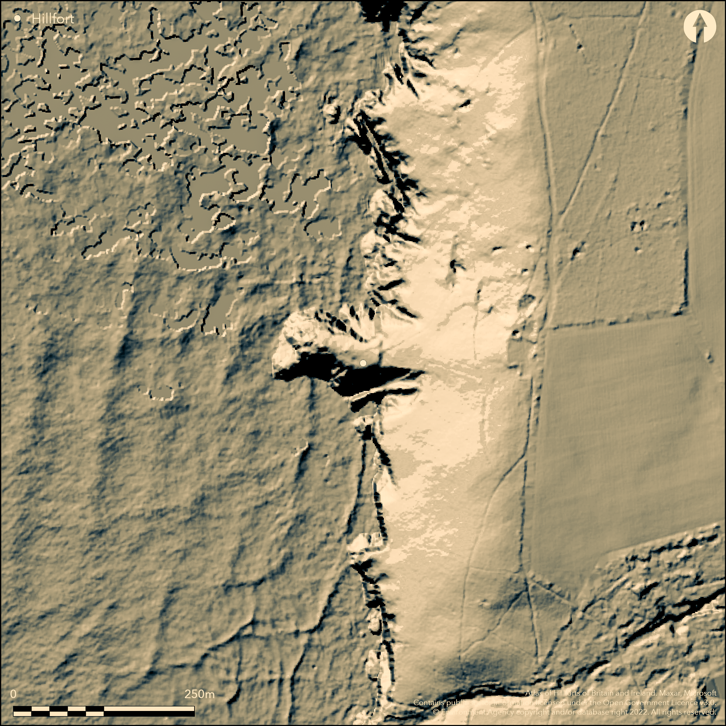
LiDAR 1m DTM Hillshade
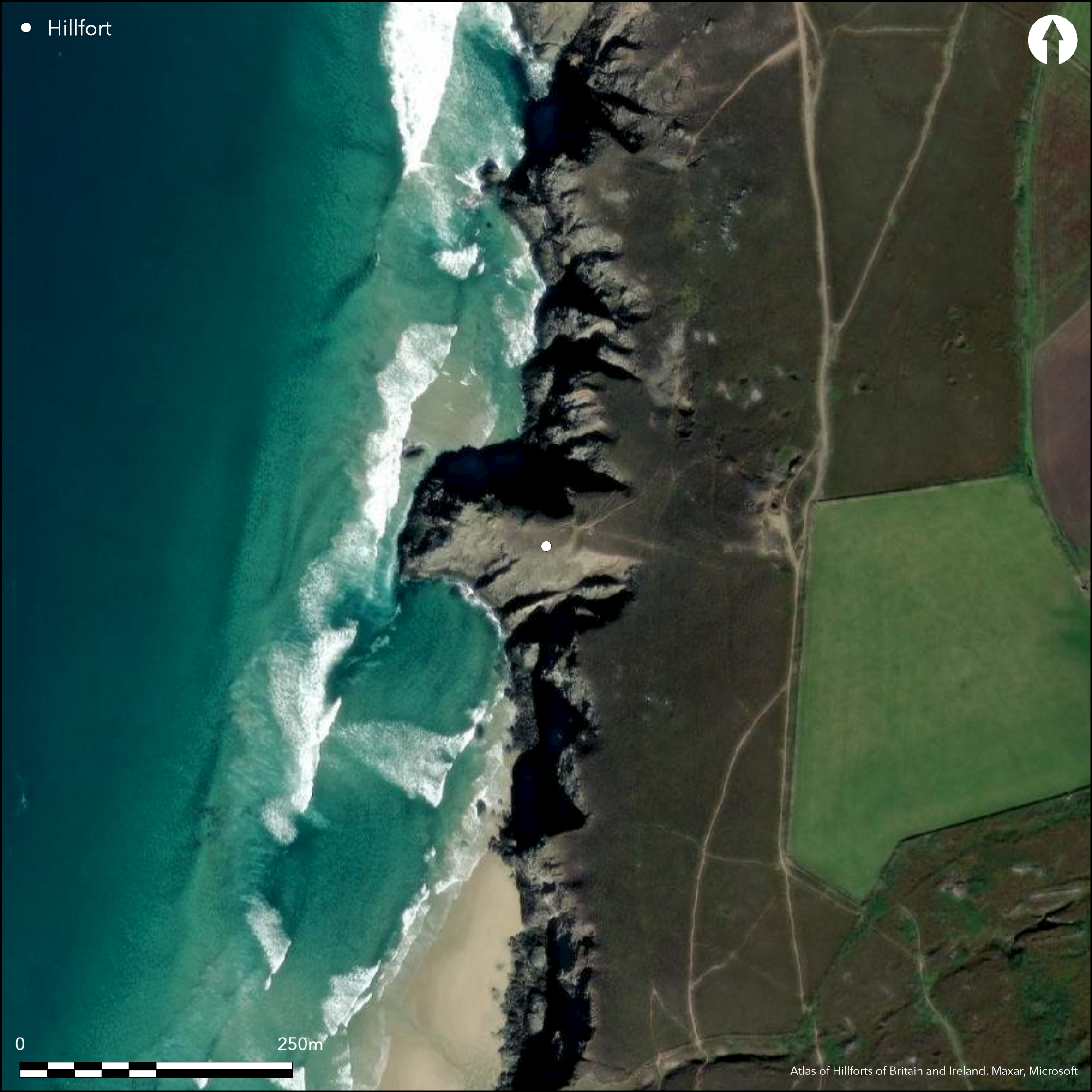
Satellite Imagery
LiDAR 1m DTM Hillshade
Satellite Imagery
Scroll left/right to view further images.
HER: Cornwall and Scilly MCO6585 (19500)
NMR: SW 65 SE 1 (426274)
SM: 1017017
NGR: SW 69833 50485
X: 169833 Y: 50485 (OSGB36)
Small promontory fort sited on eroded coastal promontory located along exposed coastline facing Atlantic, but overlooked by steeply sloping ground to E. Defined by steep natural rock sea cliffs on all sides but E, where c. 20m of bank and earth-cut ditch runs N-S across neck of promontory. Bank averages 0.9m high and 2.3m in width, encloses 0.45ha. Fronted by ditch with maximum width of 3m, outer slope formed by natural cliff slope. Simple 2m wide causeway across ditch, with similar width gap in bank, provide only entrance near N end of site. Interior comprises sloping rock promontory with further flat expanse of rock near waterline with dimensions of c. 90m E-W by 50m N-S; approximating to an internal area of about 0.45ha. Possible that bank and ditch protected a landing, as a flat expanse of rock near waterline natural quay. Occupation suggested by shell midden on NW side interior. National Trust survey 1985 found two possible hut circles close-by. Coastal grassland and bare rock. On 1st Ed. OS map (1880). Undated.
Citizen Science: ✗
Reliability of Data: Confirmed
Reliability of Interpretation: Confirmed
X: -582652 Y: 6499999 (EPSG: 3857)
Longitude: -5.234054642614369 Latitude: 50.30920904777573 (EPSG:4326)
Country: England
Current County or Unitary Authority: Cornwall
Historic County: Cornwall
Current Parish/Community/Council/Townland: St Agnes
Ramparts in fair condition despite coastal erosion of promontory. National Trust site.
| Extant | ✓ |
| Cropmark | ✗ |
| Likely Destroyed | ✓ |
Coastal grassland and bare rock.
| Woodland | ✗ |
| Commercial Forestry Plantation | ✗ |
| Parkland | ✗ |
| Pasture (Grazing) | ✗ |
| Arable | ✗ |
| Scrub/Bracken | ✗ |
| Bare Outcrop | ✗ |
| Heather/Moorland | ✗ |
| Heath | ✗ |
| Built-up | ✗ |
| Coastal Grassland | ✓ |
| Other | ✗ |
Small promontory fort (aka cliff castle) sited on eroded coastal promontory. Located along exposed coastline facing the Atlantic, but overlooked by steeply sloping ground to E. Defined by steep natural rock sea cliffs on all sides but E,
| Contour Fort | ✗ |
| Partial Contour Fort | ✗ |
| Promontory Fort | ✓ |
| Hillslope Fort | ✗ |
| Level Terrain Fort | ✗ |
| Marsh Fort | ✗ |
| Multiple Enclosure Fort | ✗ |
Located on a small promontory in exposed position
| Hilltop | ✗ |
| Coastal Promontory | ✓ |
| Inland Promontory | ✗ |
| Valley Bottom | ✗ |
| Knoll/Hillock/Outcrop | ✗ |
| Ridge | ✗ |
| Cliff/Plateau-edge/Scarp | ✗ |
| Hillslope | ✗ |
| Lowland | ✗ |
| Spur | ✗ |
Dominant Topographic Feature: Eroded coastal promontory.
| North | ✗ |
| Northeast | ✗ |
| East | ✗ |
| Southeast | ✗ |
| South | ✗ |
| Southwest | ✗ |
| West | ✗ |
| Northwest | ✗ |
| Level | ✓ |
Altitude: 50.0m
N/A
None.
Reliability: D - None
| Pre 1200BC | ✗ |
| 1200BC - 800BC | ✗ |
| 800BC - 400BC | ✗ |
| 400BC - AD50 | ✗ |
| AD50 - AD400 | ✗ |
| AD400 - AD 800 | ✗ |
| Post AD800 | ✗ |
| Unknown | ✓ |
| Pre Hillfort: | None |
| Post Hillfort: | None |
On 1st Ed. OS map (1880). Field investigation Ordnance Survey 1960. National Trust survey 1985 - no details. Plotted by NMP - no date.
| 1st Identified Map Depiction (1880): | OS map. |
| Other (1960): | Field investigation OS. |
| Other (1985): | National Trust survey. |
| Other (None): | Plotted by NMP. |
Shell midden on NW side of promontory, and National Trust survey 1985 located two possible hut circles close-by.
None
| None | ✓ |
| Spring | ✗ |
| Stream | ✗ |
| Pool | ✗ |
| Flush | ✗ |
| Well | ✗ |
| Other | ✗ |
Shell midden on NW side of promontory, and National Trust survey 1985 located two possible hut circles close-by.
| No Known Features | ✗ |
| Round Stone Structures | ✗ |
| Rectangular Stone Structures | ✗ |
| Curvilinear Platforms | ✗ |
| Other Roundhouse Evidence | ✗ |
| Pits | ✗ |
| Quarry Hollows | ✗ |
| Other | ✓ |
None
| No Known Excavation | ✓ |
| Pits | ✗ |
| Postholes | ✗ |
| Roundhouses | ✗ |
| Rectangular Structures | ✗ |
| Roads/Tracks | ✗ |
| Quarry Hollows | ✗ |
| Other | ✗ |
| Nothing Found | ✗ |
None
| No Known Geophysics | ✓ |
| Pits | ✗ |
| Roundhouses | ✗ |
| Rectangular Structures | ✗ |
| Roads/Tracks | ✗ |
| Quarry Hollows | ✗ |
| Other | ✗ |
| Nothing Found | ✗ |
None
| No Known Finds | ✓ |
| Pottery | ✗ |
| Metal | ✗ |
| Metalworking | ✗ |
| Human Bones | ✗ |
| Animal Bones | ✗ |
| Lithics | ✗ |
| Environmental | ✗ |
| Other | ✗ |
None
| APs Not Checked | ✓ |
| None | ✗ |
| Roundhouses | ✗ |
| Rectangular Structures | ✗ |
| Pits | ✗ |
| Postholes | ✗ |
| Roads/Tracks | ✗ |
| Other | ✗ |
Simple 2m wide causeway across ditch, with similar width gap in bank, provides only entrance near N end of site.
| 1: | None |
| 2: | None |
Guard Chambers: ✗
Chevaux de Frise: ✗
| 1. Simple Gap (North): | Simple wide causewayed entrance |
Defended by steep natural rock sea cliffs on all sides but E, where c. 20m of bank and earth-cut ditch runs N-S across neck of promontory. Bank averages 0.9m high and 2.3m in width. Fronted by ditch with maximum width of 3m, outer slope formed by natural cliff slope.
| Area 1: | 0.45ha. |
| Total: | 0.45ha. |
Total Footprint Area: Noneha.
None
| ✗ | None |
| ✗ | None |
| NE Quadrant: | 1 |
| SE Quadrant: | 1 |
| SW Quadrant: | 0 |
| NW Quadrant: | 0 |
| Total: | 1 |
| Partial Univallate | ✓ |
| Univallate | ✗ |
| Partial Bivallate | ✗ |
| Bivallate | ✗ |
| Partial Multivallate | ✗ |
| Multivallate | ✗ |
| Unknown | ✗ |
| Partial Univallate | ✗ |
| Univallate | ✗ |
| Partial Bivallate | ✗ |
| Bivallate | ✗ |
| Partial Multivallate | ✗ |
| Multivallate | ✗ |
Possible earthen bank.
| None | ✗ |
| Earthen Bank | ✓ |
| Stone Wall | ✗ |
| Rubble | ✗ |
| Wall-walk | ✗ |
| Evidence of Timber | ✗ |
| Vitrification | ✗ |
| Other Burning | ✗ |
| Palisade | ✗ |
| Counter Scarp Bank | ✗ |
| Berm | ✗ |
| Unfinished | ✗ |
| Other | ✗ |
None
| None | ✗ |
| Earthen Bank | ✗ |
| Stone Wall | ✗ |
| Murus Duplex | ✗ |
| Timber-framed | ✗ |
| Timber-laced | ✗ |
| Vitrification | ✗ |
| Other Burning | ✗ |
| Palisade | ✗ |
| Counter Scarp Bank | ✗ |
| Berm | ✗ |
| Unfinished | ✗ |
| No Known Excavation | ✓ |
| Other | ✗ |
| ✗ | None |
| ✓ | Earth-cut ditch |
Number of Ditches: 1
| ✗ | None |
Warner, R.B. 1967. Parish of St Agnes: checklist additions, Cornish Archaeol, 6, 97, 111.
Warner, R.B. 1967. Some new cliff castles, Cornish Archaeol, 6, 111.
Atlas of Hillforts:
Wikidata:
This work is licensed under CC BY-SA 4.0![]()
![]()
![]() and should be cited as:
and should be cited as:
Lock, Gary and Ralston, Ian. 2024. Atlas of Hillforts of Britain and Ireland. Available at: https://hillforts.arch.ox.ac.uk
Document Version 1.1