LiDAR 1m DTM Hillshade
Satellite Imagery
LiDAR 1m DTM Hillshade
Satellite Imagery
Scroll left/right to view further images.
HER: Gloucestershire 8 (None)
NMR: SP 00 SE 14 (32739)
SM: 1003322
NGR: SP090009
X: 409000 Y: 200900 (OSGB36)
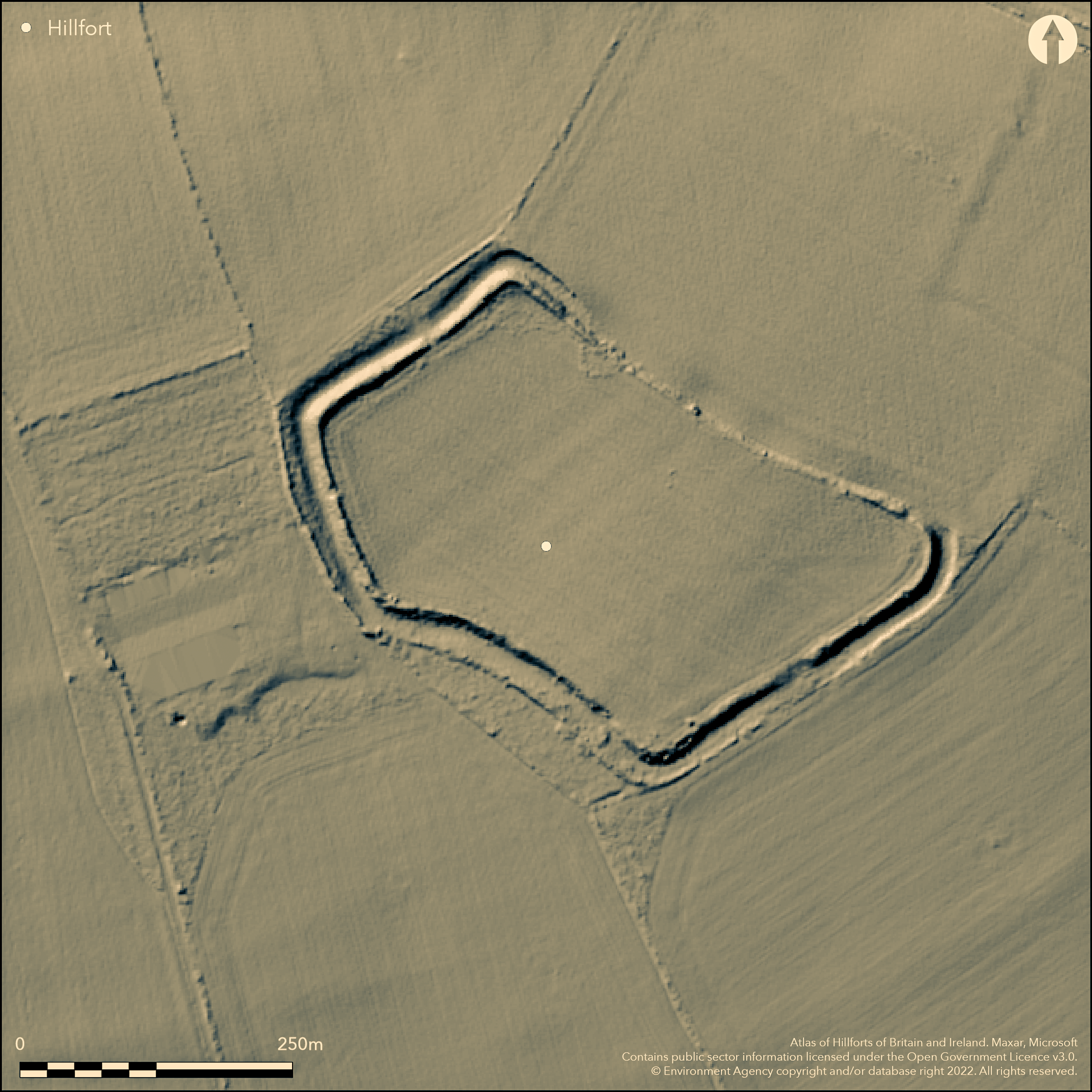
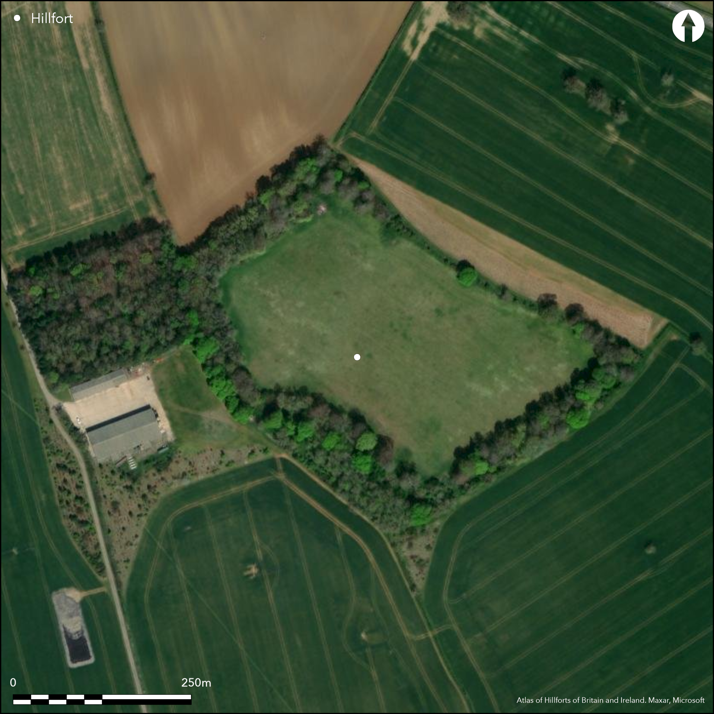
Bivallate and rectangular in plan, strongly defended partial contour hillfort sited on top of low ridge in gently undulating farmland above brooks to E and W (Ampney Brook), S of Cotswolds. Inner bank to 10.6m wide, 2.1m above interior and 3.7-5m above base of 9m wide ditch. Enclosing 4.6ha. Flat-topped and denuded outer bank, 4.6m wide and to 1.5m high, gone in middle of SE side, marked by gap in inner bank. Very shallow outer ditch exists only along S half of SW side, where 3.7m wide. Two opposing entrances on NE and NW sides, both of similar construction with a simple lowering of rampart and infilling of ditch. No trace of habitation in the undulating, spasmodically ploughed interior. Cropmark traces of a fragmented earlier ditch-defined field system. Tree and scrub covered inner rampart with much plough damage within. Topographical survey and management plan prepared 2011. On 1st Ed. OS map (1884).
Citizen Science: ✓
Reliability of Data: Confirmed
Reliability of Interpretation: Confirmed
X: -208297 Y: 6747270 (EPSG: 3857)
Longitude: -1.8711672566560633 Latitude: 51.70672188984593 (EPSG:4326)
Country: England
Current County or Unitary Authority: Gloucestershire
Historic County: Gloucestershire
Current Parish/Community/Council/Townland: Ampney St. Peter
Inner bank tree and scrub covered on NW, SE and SW, but in fair condition, but outer bank badly damaged, with ditch visible only in S part of SW side. Trees spasmodic only on NE. Extensive plough, animal and tree damage to ramparts highlighted in management plan.
| Extant | ✓ |
| Cropmark | ✗ |
| Likely Destroyed | ✗ |
Unmanaged rough grass, scrub and trees.
| Woodland | ✓ |
| Commercial Forestry Plantation | ✗ |
| Parkland | ✗ |
| Pasture (Grazing) | ✓ |
| Arable | ✗ |
| Scrub/Bracken | ✓ |
| Bare Outcrop | ✗ |
| Heather/Moorland | ✗ |
| Heath | ✗ |
| Built-up | ✗ |
| Coastal Grassland | ✗ |
| Other | ✗ |
Bivallate and rectangular in plan, strongly defended partial contour hillfort sited on top of low ridge in gently undulating farmland above brooks to E and W (Ampney Brook), S of Cotswolds.
| Contour Fort | ✗ |
| Partial Contour Fort | ✓ |
| Promontory Fort | ✗ |
| Hillslope Fort | ✗ |
| Level Terrain Fort | ✗ |
| Marsh Fort | ✗ |
| Multiple Enclosure Fort | ✗ |
Located on top of low ridge rising above undulating farmland
| Hilltop | ✗ |
| Coastal Promontory | ✗ |
| Inland Promontory | ✗ |
| Valley Bottom | ✗ |
| Knoll/Hillock/Outcrop | ✗ |
| Ridge | ✓ |
| Cliff/Plateau-edge/Scarp | ✗ |
| Hillslope | ✗ |
| Lowland | ✗ |
| Spur | ✗ |
Dominant Topographic Feature: Low ridge
| North | ✗ |
| Northeast | ✗ |
| East | ✗ |
| Southeast | ✗ |
| South | ✗ |
| Southwest | ✗ |
| West | ✗ |
| Northwest | ✗ |
| Level | ✓ |
Altitude: 110.0m
N/A
None
Reliability: D - None
| Pre 1200BC | ✗ |
| 1200BC - 800BC | ✗ |
| 800BC - 400BC | ✗ |
| 400BC - AD50 | ✗ |
| AD50 - AD400 | ✗ |
| AD400 - AD 800 | ✗ |
| Post AD800 | ✗ |
| Unknown | ✓ |
| Pre Hillfort: | None |
| Post Hillfort: | None |
On 1st Ed. OS map (1884). Aerial photograph interpretation RCHME 1992-96. Aerial photograph interpretation English Heritage , Gloucestershire NMP. Evaluation, Foundations Archaeology 2007. Management plan and topographical survey, Birmingham Archaeology and EDP 2011.
| 1st Identified Map Depiction (1824): | A. Bryant. |
| Other (1884): | OS map. |
| Other (2007): | Foundations Archaeology 2007. |
| Other (2011): | Birmingham Archaeology and EDP. |
| Other (None): | Aerial photograph interpretation RCHME. |
Blue glass bead in Stroud Museum.
None
| None | ✓ |
| Spring | ✗ |
| Stream | ✗ |
| Pool | ✗ |
| Flush | ✗ |
| Well | ✗ |
| Other | ✗ |
None
| No Known Features | ✓ |
| Round Stone Structures | ✗ |
| Rectangular Stone Structures | ✗ |
| Curvilinear Platforms | ✗ |
| Other Roundhouse Evidence | ✗ |
| Pits | ✗ |
| Quarry Hollows | ✗ |
| Other | ✗ |
None
| No Known Excavation | ✓ |
| Pits | ✗ |
| Postholes | ✗ |
| Roundhouses | ✗ |
| Rectangular Structures | ✗ |
| Roads/Tracks | ✗ |
| Quarry Hollows | ✗ |
| Other | ✗ |
| Nothing Found | ✗ |
None
| No Known Geophysics | ✓ |
| Pits | ✗ |
| Roundhouses | ✗ |
| Rectangular Structures | ✗ |
| Roads/Tracks | ✗ |
| Quarry Hollows | ✗ |
| Other | ✗ |
| Nothing Found | ✗ |
Blue glass bead in Stroud Museum.
| No Known Finds | ✓ |
| Pottery | ✗ |
| Metal | ✗ |
| Metalworking | ✗ |
| Human Bones | ✗ |
| Animal Bones | ✗ |
| Lithics | ✗ |
| Environmental | ✗ |
| Other | ✗ |
None
| APs Not Checked | ✗ |
| None | ✓ |
| Roundhouses | ✗ |
| Rectangular Structures | ✗ |
| Pits | ✗ |
| Postholes | ✗ |
| Roads/Tracks | ✗ |
| Other | ✗ |
Opposing NE and NW entrances, both of similar construction with a simple lowering of rampart and infilling of ditch.
| 4: | Two modern breaks. |
| 2: | None |
Guard Chambers: ✗
Chevaux de Frise: ✗
| 1. Simple Gap (South east): | None |
| 2. Simple Gap (North east): | None |
Inner bank to 10.6m wide, 2.1m above interior and 3.7-5m above base of 9m wide ditch. Flat-topped and denuded outer bank, 4.6m wide and to 1.5m high, destroyed in middle of SE side, marked by gap in inner bank. Very shallow outer ditch exists only along S half of SW side, where 3.7m wide.
| Area 1: | 4.6ha. |
| Total: | 4.6ha. |
Total Footprint Area: Noneha.
None
| ✗ | None |
| ✓ | None |
| NE Quadrant: | 2 |
| SE Quadrant: | 1 |
| SW Quadrant: | 2 |
| NW Quadrant: | 2 |
| Total: | 2 |
| Partial Univallate | ✓ |
| Univallate | ✗ |
| Partial Bivallate | ✓ |
| Bivallate | ✗ |
| Partial Multivallate | ✗ |
| Multivallate | ✗ |
| Unknown | ✗ |
| Partial Univallate | ✗ |
| Univallate | ✗ |
| Partial Bivallate | ✗ |
| Bivallate | ✗ |
| Partial Multivallate | ✗ |
| Multivallate | ✗ |
None
| None | ✗ |
| Earthen Bank | ✓ |
| Stone Wall | ✗ |
| Rubble | ✗ |
| Wall-walk | ✗ |
| Evidence of Timber | ✗ |
| Vitrification | ✗ |
| Other Burning | ✗ |
| Palisade | ✗ |
| Counter Scarp Bank | ✗ |
| Berm | ✗ |
| Unfinished | ✗ |
| Other | ✗ |
None
| None | ✗ |
| Earthen Bank | ✗ |
| Stone Wall | ✗ |
| Murus Duplex | ✗ |
| Timber-framed | ✗ |
| Timber-laced | ✗ |
| Vitrification | ✗ |
| Other Burning | ✗ |
| Palisade | ✗ |
| Counter Scarp Bank | ✗ |
| Berm | ✗ |
| Unfinished | ✗ |
| No Known Excavation | ✓ |
| Other | ✗ |
| ✗ | None |
| ✓ | Very shallow outer ditch exists only along S half of SW side, where 3.7m wide. |
Number of Ditches: 2
| ✗ | None |
Burrow, E.J. 1919: The ancient entrenchments and camps of Gloucestershire, Cheltenham: Author, 26.
Hood, A. 2007. Land at Ranbury Ring, Ampney St. Peter. Archaeological Evaluation.
Unpublished report Foundations Archaeology.
Lewis, D. 2011. Ranbury Farm, Ampney St. Peter management plan for Ranbury Ring, Unpublished report EDP.
RCHME 1976. Ancient and historical monuments in the County of Gloucestershire, Vol. I: Iron Age and Romano- British monuments in Gloucestershire Cotswolds, London: HMSO, 3-4.
Saville, A. ed 1984. Archaeology in Gloucestershire from earliest hunters to the industrial age: essays dedicated to Helen O'Neil and the late Elsie Clifford, 143, 165.
Witts, G.B. 1883. Archaeological handbook of the County of Gloucestershire, Cheltenham: Norman Brothers.
Atlas of Hillforts:
Wikidata:
This work is licensed under CC BY-SA 4.0![]()
![]()
![]() and should be cited as:
and should be cited as:
Lock, Gary and Ralston, Ian. 2024. Atlas of Hillforts of Britain and Ireland. Available at: https://hillforts.arch.ox.ac.uk
Document Version 1.1