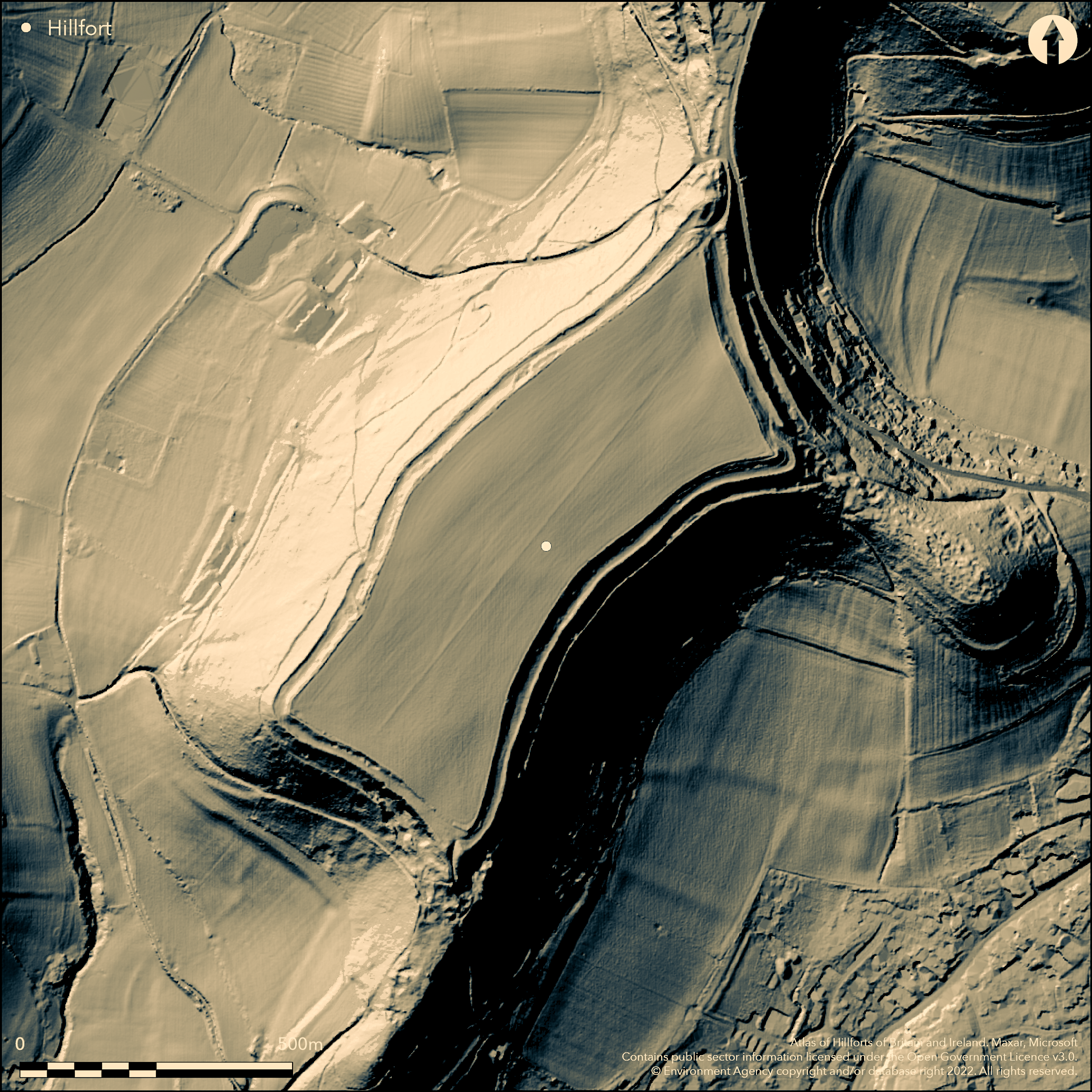
LiDAR 1m DTM Hillshade
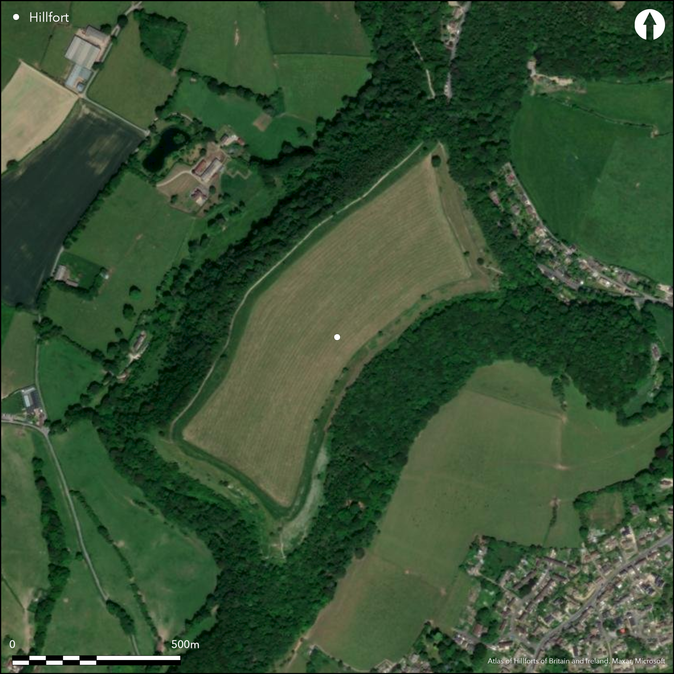
Satellite Imagery
LiDAR 1m DTM Hillshade
Satellite Imagery
Scroll left/right to view further images.
HER: Gloucestershire 261 (None)
NMR: ST 79 NE 15 (205226)
SM: 1004866
NGR: ST785989
X: 378500 Y: 198900 (OSGB36)
Large, unusual, multivallate partial contour hillfort located on a SE-facing above the valley of the River Ewelme to the S. Very steep slopes on all sides, with very narrow neck of land (col) to N connecting with the main mass of the Cotswold scarp. Measures 600 by 200m internally, encloses 16ha. Generally flat interior with unusual long sub-rectangular shape. Bivallate on all sides and downslope scarping or terracing provide extra defence. On part of SW side possible third rampart. Defences possibly constructed likely by terracing the already steep natural slopes as no inner facing scarp adjoining interior and only small bank adjoining a berm at foot of first rampart. Narrow berm with vestiges of counterscarp indicate the extent of second rampart. N, E and S entrances at corners, with hollow ways to S and E. Finds from excavations at E entrance 1976 prior to pipeline laying included Iron Age pottery, a bronze ring-headed pin, pennanular brooch, two shale armulets and glass bead. During laying of pipe 'between the two entrances' Roman or sub-Roman crouched burial beneath two layers of limestone slabs, rubbish pit and two Iron Age currency bars; all indicating significant Iron Age and later presence (Savile and Ellison 1983). These, together with significant pre-hillfort Neolithic artefacts, suggest interest in site for millennia. C14 date. Much affected by ploughing, quarrying and works generally. On OS 1" map 1813.
Citizen Science: ✗
Reliability of Data: Confirmed
Reliability of Interpretation: Confirmed
X: -257419 Y: 6743978 (EPSG: 3857)
Longitude: -2.3124379779821593 Latitude: 51.688394375098234 (EPSG:4326)
Country: England
Current County or Unitary Authority: Gloucestershire
Historic County: Gloucestershire
Current Parish/Community/Council/Townland: Uley
Once the finest hillfort in the Cotswolds, but much mutilated by quarrying, ploughing and works and in poor condition.
| Extant | ✓ |
| Cropmark | ✗ |
| Likely Destroyed | ✗ |
Quarrying.
| Woodland | ✗ |
| Commercial Forestry Plantation | ✗ |
| Parkland | ✗ |
| Pasture (Grazing) | ✓ |
| Arable | ✗ |
| Scrub/Bracken | ✗ |
| Bare Outcrop | ✗ |
| Heather/Moorland | ✗ |
| Heath | ✗ |
| Built-up | ✗ |
| Coastal Grassland | ✗ |
| Other | ✓ |
Large, unusual, sub-rectangular and bivallate partial contour hillfort located on a SE-facing above the valley of the River Ewelme to the S. Very steep slopes on all sides, with very narrow neck of land (col) to N connecting with the main mass of the Cotswold scarp.
| Contour Fort | ✗ |
| Partial Contour Fort | ✓ |
| Promontory Fort | ✗ |
| Hillslope Fort | ✗ |
| Level Terrain Fort | ✗ |
| Marsh Fort | ✗ |
| Multiple Enclosure Fort | ✗ |
Located on steep natural slopes, the defences possibly scarped
| Hilltop | ✗ |
| Coastal Promontory | ✗ |
| Inland Promontory | ✗ |
| Valley Bottom | ✗ |
| Knoll/Hillock/Outcrop | ✗ |
| Ridge | ✗ |
| Cliff/Plateau-edge/Scarp | ✗ |
| Hillslope | ✗ |
| Lowland | ✗ |
| Spur | ✓ |
Dominant Topographic Feature: Spur
| North | ✗ |
| Northeast | ✗ |
| East | ✗ |
| Southeast | ✓ |
| South | ✗ |
| Southwest | ✗ |
| West | ✗ |
| Northwest | ✗ |
| Level | ✓ |
Altitude: 215.0m
N/A
Finds from excavations 1976 prior to pipeline laying included Iron Age pottery, bronze ringheaded pin, pennanular brooch, two shale armulets and a glass bead. During laying of pipe 'between the two entrances' crouched burial beneath two layers of limestone slabs, rubbish pit and two Iron Age currency bars; all indicating a significant Iron Age presence and later Roman interest. C14 No. HAR 2289.
Reliability: B - Medium
| Pre 1200BC | ✗ |
| 1200BC - 800BC | ✗ |
| 800BC - 400BC | ✓ |
| 400BC - AD50 | ✓ |
| AD50 - AD400 | ✗ |
| AD400 - AD 800 | ✗ |
| Post AD800 | ✗ |
| Unknown | ✗ |
| Pre Hillfort: | None |
| Post Hillfort: | None |
| Artefactual: | Various dateable finds. |
| C14: | Charcoal from layer 11, thick occupation debris (?redeposited) behind rampart near N entrance - No. HAR 2289. |
On OS 1" map 1813. Small trial excavation A. Saville and A.B. Ellison 1976. Watching Brief, C. Parry, Archaeological Service Gloucestershire County Council 1993. Watching Brief D. Evans, Cotswold Archaeology 2004. RCHME survey, ref. no. 904022.
| 1st Identified Map Depiction (1813): | OS map. |
| Excavation (1976): | A. Saville and A.B. Ellison, Western Archaeological Trust. |
| Excavation (1993): | Watching Brief, C. Parry, Archaeological Service Gloucestershire County Council |
| Other (2004): | Watching Brief D. Evans, Cotswold Archaeology 2004. |
| Earthwork Survey (None): | None |
Trial excavations at E entrance 1976, prior to the laying of pipeline through fort, found turf and timber entrance passage and Iron Age road metalling. During pip rubbish pit found. Uninscribed gold stater (In Gloucester City Museum). Roman quern (In Stroud Museum). Low relief bronze mask (In Corinium Museum). Trial excavations at E entrance, prior to pipeline through site, 1976 found Iron Age pottery, bronze ringheaded pin,pennanular brooch, two shale armulets and glass bead. During laying of pipe 'between the two entrances' crouched burial beneath two layers of limestone slabs, two Iron Age currency bars also found. Cheltenham Museum houses extensive collection of 2000+ flint artefacts (mainly from the Paine Collection) including arrowheads, scrapers, knapping debris and 11 fragments from polished implements.
None
| None | ✓ |
| Spring | ✗ |
| Stream | ✗ |
| Pool | ✗ |
| Flush | ✗ |
| Well | ✗ |
| Other | ✗ |
None
| No Known Features | ✓ |
| Round Stone Structures | ✗ |
| Rectangular Stone Structures | ✗ |
| Curvilinear Platforms | ✗ |
| Other Roundhouse Evidence | ✗ |
| Pits | ✗ |
| Quarry Hollows | ✗ |
| Other | ✗ |
Trial excavations at E entrance 1976, prior to the laying of pipeline through fort, found turf and timber entrance passage and Iron Age road metalling; into interior? Also a pit found.
| No Known Excavation | ✗ |
| Pits | ✓ |
| Postholes | ✗ |
| Roundhouses | ✗ |
| Rectangular Structures | ✗ |
| Roads/Tracks | ✓ |
| Quarry Hollows | ✗ |
| Other | ✓ |
| Nothing Found | ✗ |
None
| No Known Geophysics | ✓ |
| Pits | ✗ |
| Roundhouses | ✗ |
| Rectangular Structures | ✗ |
| Roads/Tracks | ✗ |
| Quarry Hollows | ✗ |
| Other | ✗ |
| Nothing Found | ✗ |
Uninscribed gold stater (In Gloucester City Museum). Roman quern (In Stroud Museum). Low relief bronze mask (In Corinium Museum). Trial excavations at E entrance, prior to pipeline through site, 1976 found Iron Age pottery, bronze ringheaded pin, pennanular brooch, two shale armulets and glass bead. During laying of pipe 'between the two entrances' crouched burial beneath two layers of limestone slabs, two Iron Age currency bars also found. Cheltenham Museum houses extensiv collection of 2000+ flint artefacts (mainly from the Paine Collection) including arrowheads, scrapers, knapping debris and 11 fragments from polished implements.
| No Known Finds | ✗ |
| Pottery | ✓ |
| Metal | ✓ |
| Metalworking | ✗ |
| Human Bones | ✓ |
| Animal Bones | ✗ |
| Lithics | ✓ |
| Environmental | ✗ |
| Other | ✓ |
None
| APs Not Checked | ✓ |
| None | ✗ |
| Roundhouses | ✗ |
| Rectangular Structures | ✗ |
| Pits | ✗ |
| Postholes | ✗ |
| Roads/Tracks | ✗ |
| Other | ✗ |
N, E and S entrances at corners, with hollow ways to S and E. Main to N where the narrow neck of land joins the spur to main Cotswold mass. Here, access from N by way of a col, inturned ends of the banks with short hollow way lying obliquely across it. Outside N entrance formerly series of banks and ditches across the col noted in 19th century, but most gone, and surviving features natural. Smaller entrances to E and S cut through outer rampart only. Trial excavations at E entrance 1976, prior to the laying of pipeline through fort, found turf and timber entrance passage and Iron Age road metalling. Possible that another entrance gap in outer rampart at ST 78289888, but may be result of later working. At E corner overlapping bank ends associated with hollow-way, and at damaged S entrance another hollow-way, flanked on west by downward extension of bank, and by two partly artificial mounds. Roads shown on the OS 1" map 1830 passed through S and E entrances. and traversed the eastern terrace.
| 4: | None |
| 2: | None |
Guard Chambers: ✗
Chevaux de Frise: ✗
| 1. In-turned (North): | Access from N by way of a col, inturned ends of the banks with short hollow-way lying obliquely across it. |
| 1. Hollow Way (North): | Short hollow way lying obliquely across col. |
| 2. Hollow Way (East): | None |
| 3. Hollow Way (South): | None |
Bivallate on all sides and downslope scarping or terracing provide extra defence. On part of SW side third rampart. Defences possibly constructed likely by terracing the already steep natural slopes as no inner facing scarp adjoining interior and only small bank adjoining a berm at foot of first rampart. Narrow berm with vestiges of counterscarp indicate the extent of second rampart.
| Area 1: | 16.0ha. |
| Total: | 16.0ha. |
Total Footprint Area: Noneha.
None
| ✗ | None |
| ✓ | None |
| NE Quadrant: | 2 |
| SE Quadrant: | 2 |
| SW Quadrant: | 3 |
| NW Quadrant: | 2 |
| Total: | 3 |
| Partial Univallate | ✗ |
| Univallate | ✗ |
| Partial Bivallate | ✓ |
| Bivallate | ✗ |
| Partial Multivallate | ✓ |
| Multivallate | ✗ |
| Unknown | ✗ |
| Partial Univallate | ✗ |
| Univallate | ✗ |
| Partial Bivallate | ✗ |
| Bivallate | ✗ |
| Partial Multivallate | ✗ |
| Multivallate | ✗ |
Narrow berm with vestiges of counterscarp indicate the entent of second rampart.
| None | ✗ |
| Earthen Bank | ✓ |
| Stone Wall | ✗ |
| Rubble | ✗ |
| Wall-walk | ✗ |
| Evidence of Timber | ✗ |
| Vitrification | ✗ |
| Other Burning | ✗ |
| Palisade | ✗ |
| Counter Scarp Bank | ✓ |
| Berm | ✓ |
| Unfinished | ✗ |
| Other | ✗ |
None
| None | ✗ |
| Earthen Bank | ✗ |
| Stone Wall | ✗ |
| Murus Duplex | ✗ |
| Timber-framed | ✗ |
| Timber-laced | ✗ |
| Vitrification | ✗ |
| Other Burning | ✗ |
| Palisade | ✗ |
| Counter Scarp Bank | ✗ |
| Berm | ✗ |
| Unfinished | ✗ |
| No Known Excavation | ✓ |
| Other | ✗ |
| ✗ | None |
| ✓ | Ditches not defined. |
Number of Ditches: 2
| ✗ | None |
Darvill, T. 2011. Prehistoric Gloucestershire. Forests and vales and high blue hills, 2nd Edition, Stroud: Amberley Publishing.
Evans D. 2004. Uley Bury, Gloucestershire. Programme of Archaeological Recording, Unpublished report Cotswold Archaeology.
Parry C. 1993. Uley Bury Camp, Gloucestershire: Note on the replacement of a stile at ST 7830098927, June 1993. Unpublished report Gloucestershire County Council, Archaeology Section.
RCHME 1976. Ancient and historical monuments in the County of Gloucestershire, Vol. I: Iron Age and Romano- British monuments in Gloucestershire Cotswolds, London: HMSO, 121b.
Saville, A. and Ellison, A. 1983. Uley Bury and Norbury hillforts: rescue excavations at two Gloucestershire Iron Age sites. Bristol: Western Archaeological Trust.
Saville, A and Ellison, A. 1983. Excavations at Uley Bury hillfort, Gloucestershire, 1976. Bristol: Western Archaeological Trust excavation monograph 5.
Atlas of Hillforts:
Wikidata:
This work is licensed under CC BY-SA 4.0

 and should be cited as:
Lock, Gary and Ralston, Ian. 2024. Atlas of Hillforts of Britain and Ireland. Available at: https://hillforts.arch.ox.ac.uk
Document Version 1.1