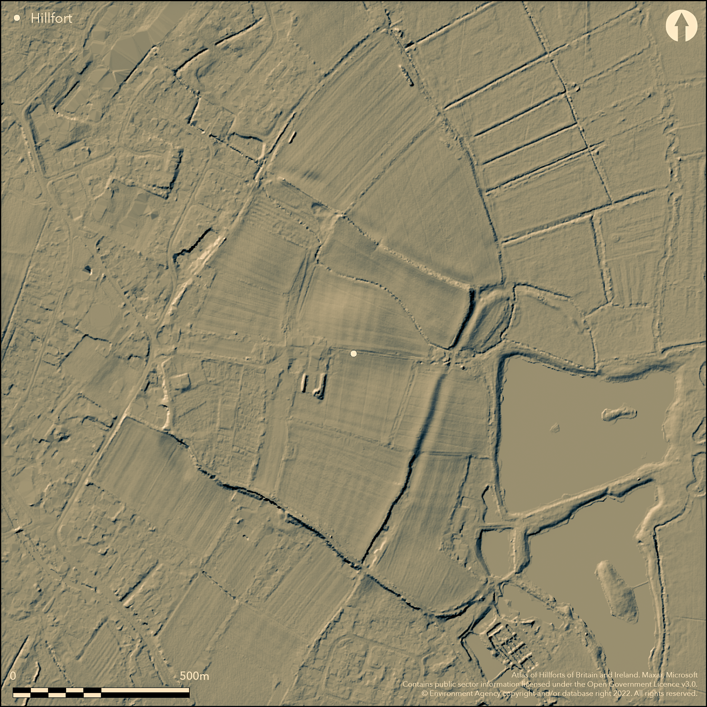
LiDAR 1m DTM Hillshade
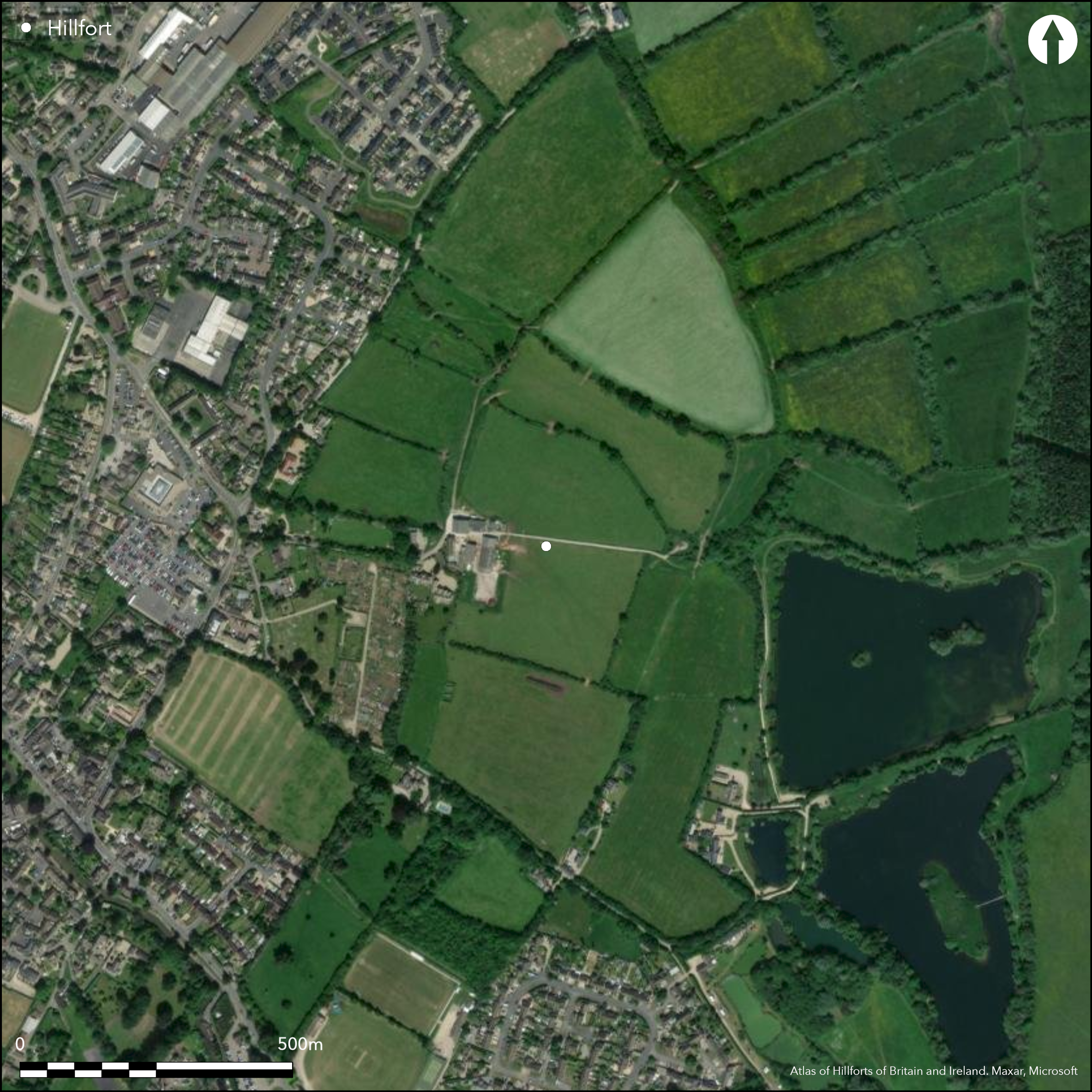
Satellite Imagery
LiDAR 1m DTM Hillshade
Satellite Imagery
Scroll left/right to view further images.
HER: Gloucestershire 342 (None)
NMR: SP 12 SE 2 (330369)
SM: 1017340
NGR: SP174209
X: 417400 Y: 220900 (OSGB36)
Bivallate part marsh fort and part level terrain fort, enclosing c. 23ha located on virtual flat ground in open valley on gravel terrace in angle between the Rivers Windrush and Dikler and confluence of the River Dilker and River Eye, immediately to E of Bouton-on-Water. Site, rectilinear in form, with two close-set ramparts to 2m high, each with external ditches, visible on N, E and S sides, with external ditches, but W destroyed by development. Much assessed by geophysical survey and evaluation prior to development and intermittent excavation. Main period of occupation Iron Age. N and W entrances, latter destroyed. On E banks with external ditches for c. 50m E from the NE and SE corners of enclosure defining annexe c. 6ha, flanking marshy near River Dickler. Most significant excavation 1931-34 (Dunning 1976), and later by others to 1990's, again prompted by development proposals. Possible occupancy 4th century BC to 4th century AD. Dunning found evidence for two phases of Iron Age occupation, pre-Iron Age, Iron Age and Roman occupation and Saxon activity. In 1881 entire circuit could still traced and masonry noted in main rampart. Pre Iron Age to Roman finds. Roundhouses and pits. Saxon inhumations. Hoard of 143 currency bars hoard in 1860. Suggested causewayed enclosure not proven. On 1st Ed. OS map (1886). Suggested it may be an enclosed oppida in the late Iron Age (Cunliffe and Rowley 1976).
Citizen Science: ✗
Reliability of Data: Confirmed
Reliability of Interpretation: Confirmed
X: -194654 Y: 6779602 (EPSG: 3857)
Longitude: -1.748605272202344 Latitude: 51.8863478520817 (EPSG:4326)
Country: England
Current County or Unitary Authority: Gloucestershire
Historic County: Gloucestershire
Current Parish/Community/Council/Townland: Bourton-on-the-Water
Remants visible, but under pasture and well-preserved as such on N, E and S sides. Destroyed by development on W.
| Extant | ✓ |
| Cropmark | ✗ |
| Likely Destroyed | ✓ |
None
| Woodland | ✗ |
| Commercial Forestry Plantation | ✗ |
| Parkland | ✗ |
| Pasture (Grazing) | ✓ |
| Arable | ✗ |
| Scrub/Bracken | ✗ |
| Bare Outcrop | ✗ |
| Heather/Moorland | ✗ |
| Heath | ✗ |
| Built-up | ✓ |
| Coastal Grassland | ✗ |
| Other | ✗ |
Bivallate part marsh and part level terrain fort, enclosing c. 23ha located on virtual flat ground in open valley on gravel terrace in angle between the Rivers Windrush and Dikler and confluence of the River Dilker and River Eye, immediately to E of Bouton-on-Water.
| Contour Fort | ✗ |
| Partial Contour Fort | ✗ |
| Promontory Fort | ✗ |
| Hillslope Fort | ✗ |
| Level Terrain Fort | ✓ |
| Marsh Fort | ✓ |
| Multiple Enclosure Fort | ✗ |
Sited near to the confluence of the River Dikler and River Eye
| Hilltop | ✗ |
| Coastal Promontory | ✗ |
| Inland Promontory | ✗ |
| Valley Bottom | ✓ |
| Knoll/Hillock/Outcrop | ✗ |
| Ridge | ✗ |
| Cliff/Plateau-edge/Scarp | ✗ |
| Hillslope | ✗ |
| Lowland | ✓ |
| Spur | ✗ |
Dominant Topographic Feature: Flat gravel terrace between rivers.
| North | ✗ |
| Northeast | ✗ |
| East | ✗ |
| Southeast | ✗ |
| South | ✗ |
| Southwest | ✗ |
| West | ✗ |
| Northwest | ✗ |
| Level | ✓ |
Altitude: 129.0m
N/A
Excavation suggests possible occupancy 4th century BC to 4th century AD. Dunning suggested two phases of Iron Age occupation. First preceded construction of defences, dated to later first century BC. Second phase of occupation corresponded with construction of enclosure and dated to first half of first century AD. Pre-enclosure activity include pits, Palaeolithic tranchet axe, flint flakes, arrowheads, Peterborough ware pottery of late Neolithic/ early Bronze Age date and ring ditch and ditch segments of probable Bronze Age. Human bone, pottery, and other artefacts of Iron Age date. Considerable evidence for occupation during Roman period. Saxon inhumations from interior and on line of defences.
Reliability: B - Medium
| Pre 1200BC | ✗ |
| 1200BC - 800BC | ✗ |
| 800BC - 400BC | ✗ |
| 400BC - AD50 | ✓ |
| AD50 - AD400 | ✓ |
| AD400 - AD 800 | ✗ |
| Post AD800 | ✗ |
| Unknown | ✗ |
| Pre Hillfort: | None |
| Post Hillfort: | None |
| Artefactual: | Many dateable finds. |
Site mentioned in grant by Offa in AD 779. First plan 1840 by Sir Henry Dryden and W Lukis. Excavation 1931-34 by G.C. Dunning. Court leet of the liberty of Salmonsbury was held twice a year up to mid-19th century at a gap on NE side of hillfort. On 1st Ed. OS map (1886). Various evaluations for development 1987-2006. Watching Briefs 1997-2009. Geophysical surveys 1987-2011. Various small excavations, 1956, 1980's and 1990's. Small evaluation trenches 2011.
| 1st Identified Written Reference (779): | Site mentioned in grant by Offa. |
| 1st Identified Map Depiction (1840): | First plan by Sir Henry Dryden and W Lukis. |
| Excavation (None): | G.C. Dunning. |
| Excavation (None): | Various small excavations, 1956, 1980's and 1990's. |
| Other (None): | Evaluations. |
| Geophysical Survey (None): | Geophysical surveys. |
| Other (None): | Watching Briefs. |
Round houses, rubbish pits, human bone, pottery, and other artefacts of Iron Age date. Pre-enclosure activity include pits, Palaeolithic tranchet axe, flint flakes, arrowheads, Peterborough ware pottery of late Neolithic/ early Bronze Age date and ring ditch and ditch segments of probable Bronze Age. Hoard of 143 currency bars found 1860. Saxon inhumations.Medieval pottery.
Possible on site.
| None | ✗ |
| Spring | ✓ |
| Stream | ✗ |
| Pool | ✗ |
| Flush | ✗ |
| Well | ✗ |
| Other | ✗ |
None
| No Known Features | ✗ |
| Round Stone Structures | ✗ |
| Rectangular Stone Structures | ✗ |
| Curvilinear Platforms | ✗ |
| Other Roundhouse Evidence | ✓ |
| Pits | ✗ |
| Quarry Hollows | ✗ |
| Other | ✗ |
Round houses and rubbish pits. Post holes and hearth.
| No Known Excavation | ✗ |
| Pits | ✓ |
| Postholes | ✓ |
| Roundhouses | ✓ |
| Rectangular Structures | ✗ |
| Roads/Tracks | ✗ |
| Quarry Hollows | ✗ |
| Other | ✓ |
| Nothing Found | ✗ |
Geophysics not determined.
| No Known Geophysics | ✗ |
| Pits | ✗ |
| Roundhouses | ✗ |
| Rectangular Structures | ✗ |
| Roads/Tracks | ✗ |
| Quarry Hollows | ✗ |
| Other | ✓ |
| Nothing Found | ✗ |
Human bone, pottery, and other artefacts of Iron Age date. Pre-enclosure activity include pits, Palaeolithic tranchet axe, flint flakes, arrowheads, Peterborough ware pottery of late Neolithic/ early Bronze Age date. Hoard of 143 currency bars found 1860. Saxon inhumations. Medieval pottery.
| No Known Finds | ✗ |
| Pottery | ✓ |
| Metal | ✓ |
| Metalworking | ✗ |
| Human Bones | ✓ |
| Animal Bones | ✗ |
| Lithics | ✓ |
| Environmental | ✗ |
| Other | ✗ |
None
| APs Not Checked | ✓ |
| None | ✗ |
| Roundhouses | ✗ |
| Rectangular Structures | ✗ |
| Pits | ✗ |
| Postholes | ✗ |
| Roads/Tracks | ✗ |
| Other | ✗ |
Two original entrances, simple gaps, one in centre of N side, still visible, other in centre of W side, now built over.
| 2: | Still visible. |
| 2: | None |
Guard Chambers: ✗
Chevaux de Frise: ✗
| 1. Simple Gap (North): | None |
| 2. Simple Gap (West): | Built over. |
Site, rectilinear in form, with two close-set ramparts to 2m high, each with external ditches, visible on N, E and S sides, with external ditches, but W destroyed by development. Dunning excavated section through middle of defences on SE side. Inner rampart simple construction of gravel from inner ditch with revetment of slabs of Oolite. Outer rampart ploughed down in Roman times. Outer ditch V-shaped.
| Area 1: | 23.0ha. |
| Total: | 23.0ha. |
Total Footprint Area: 29.0ha.
None
| ✓ | Dunning found evidence for two phases of Iron Age occupation, pre-Iron Age, Iron Age and Roman occupation and Saxon activity. |
| ✗ | None |
| NE Quadrant: | 2 |
| SE Quadrant: | 2 |
| SW Quadrant: | 0 |
| NW Quadrant: | 0 |
| Total: | 2 |
| Partial Univallate | ✗ |
| Univallate | ✗ |
| Partial Bivallate | ✓ |
| Bivallate | ✗ |
| Partial Multivallate | ✗ |
| Multivallate | ✗ |
| Unknown | ✗ |
| Partial Univallate | ✗ |
| Univallate | ✓ |
| Partial Bivallate | ✗ |
| Bivallate | ✗ |
| Partial Multivallate | ✗ |
| Multivallate | ✗ |
In 1881 masonry noted in main rampart.
| None | ✗ |
| Earthen Bank | ✓ |
| Stone Wall | ✓ |
| Rubble | ✗ |
| Wall-walk | ✗ |
| Evidence of Timber | ✗ |
| Vitrification | ✗ |
| Other Burning | ✗ |
| Palisade | ✗ |
| Counter Scarp Bank | ✗ |
| Berm | ✗ |
| Unfinished | ✗ |
| Other | ✗ |
Dunning excavated section through middle of defences on SE side. Inner rampart simple construction of gravel from inner ditch with revetment of slabs of Oolite. Outer rampart ploughed down in Roman times. Outer ditch V-shaped.
| None | ✗ |
| Earthen Bank | ✓ |
| Stone Wall | ✓ |
| Murus Duplex | ✗ |
| Timber-framed | ✗ |
| Timber-laced | ✗ |
| Vitrification | ✗ |
| Other Burning | ✗ |
| Palisade | ✗ |
| Counter Scarp Bank | ✗ |
| Berm | ✗ |
| Unfinished | ✗ |
| No Known Excavation | ✗ |
| Other | ✓ |
| ✗ | None |
| ✓ | V-shaped outer ditch. |
Number of Ditches: 2
| ✓ | On E banks with external ditches project for c. 50m E from the NE and SE corners of enclosure defining annexe c. 6ha, flanking marshy near River Dickler. |
Barker, P. and Mercer, E. 2001. A GEOPHYSICAL SURVEY CARRIED OUT AT CEMETERY LANE, BOURTON-ON-THE-WATER, GLOuCESTERSHIRE, STRATASCAN 1532.
Brown, I. 2009. Beacons in the landscape. The hillforts of England and Wales, Oxford: Windgather Press.
Cunliffe, B. and Rowley, T. (eds) 1976. Oppida: the beginnings of urbanisation in Barbarian Europe, BAR Int Ser 11.
Dunning, G.C. 1976. Salmonsbury, Bourton-on-the-Water, Gloucestershire, in ed D.W. Harding , Hillforts. Later prehistoric earthworks in Britain and Ireland, London: Academic Press, 75-118.
Marshall A. 1995. MAGNETOMETER SURVEY OVER THE INTERIOR OF THE MULTIVALLATE ENCLOSURE at Salmonsbury, Bourton-on-the-Water, Glos., AML report.
Rawes, B.1984. Observations at Salmonsbury Camp, 1983 [2 crouched burials, EIA pottery], Trans Bristol Gloucestershire Archaeol Soc 102, 215-19.
RCHME 1976. Ancient and historical monuments in the County of Gloucestershire, Vol. I: Iron Age and Romano- British monuments in Gloucestershire Cotswolds, London: HMSO, 17-19.
Atlas of Hillforts:
Wikidata:
This work is licensed under CC BY-SA 4.0

 and should be cited as:
Lock, Gary and Ralston, Ian. 2024. Atlas of Hillforts of Britain and Ireland. Available at: https://hillforts.arch.ox.ac.uk
Document Version 1.1