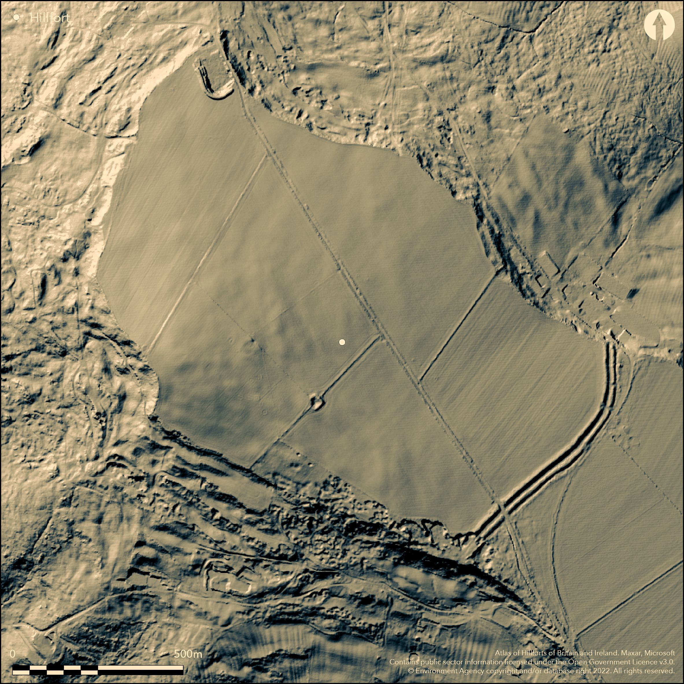
LiDAR 1m DTM Hillshade
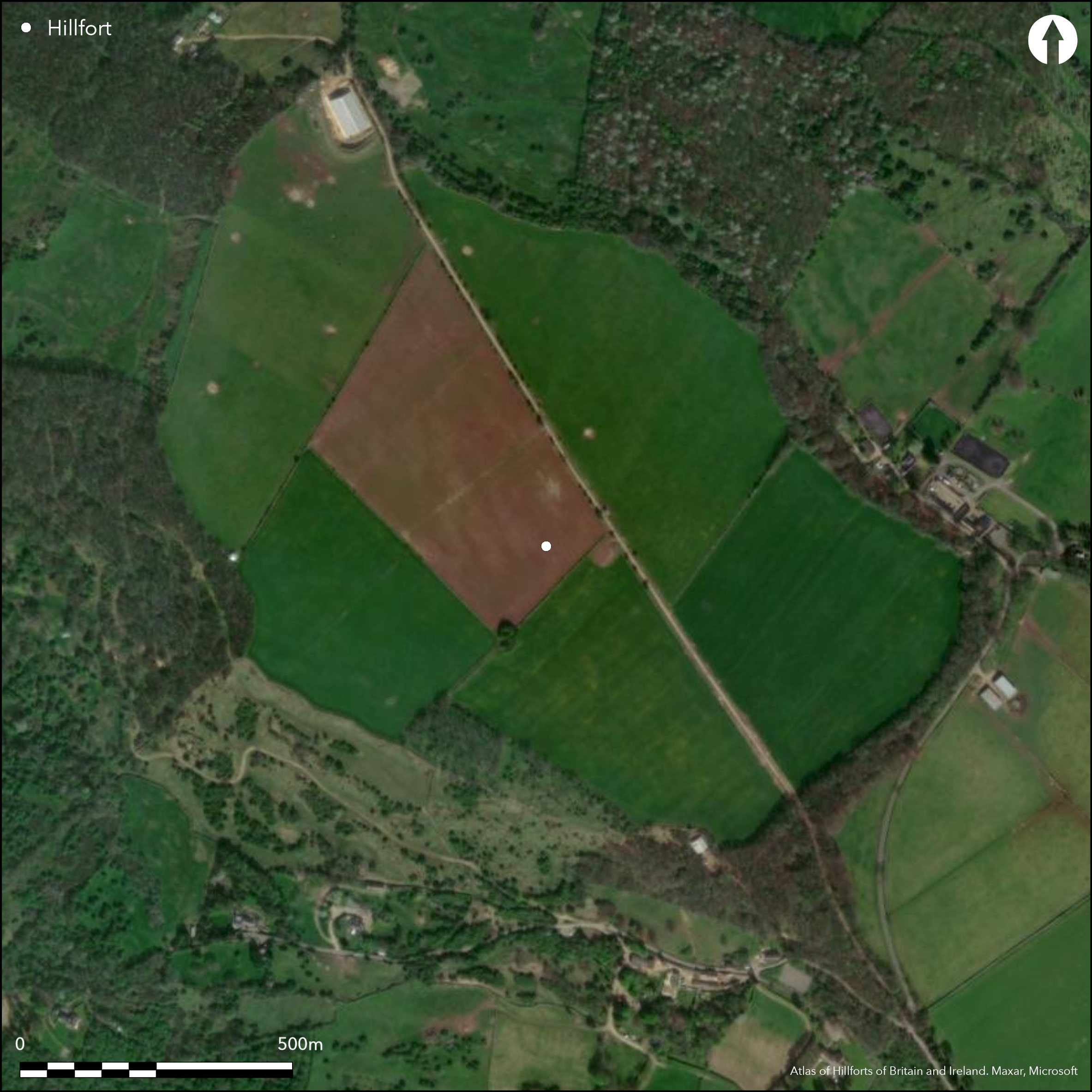
Satellite Imagery
LiDAR 1m DTM Hillshade
Satellite Imagery
Scroll left/right to view further images.
HER: Gloucestershire 430 (None)
NMR: SO 92 NE 6 (117615)
SM: 1004864
NGR: SO983284
X: 398300 Y: 228400 (OSGB36)
Inland promontory hillfort located on prominent NW-facing Cotswold spur of Nottingham Hill. Very steep surrounding slopes to W, steep to NE and SW and moderate along ridge to SE. Two banks, each with outer ditch, cut off 48.6ha of spur to SE, with rest steep natural scarps, apart from E where possible artificial scarping. Vestiges of possible third outer bank. Inner bank sited on rising ground c. 1.5m above interior and 3m above inner ditch. Less massive outer bank, directly from edge of inner ditch, reaches 2m above outer ditch. Entrance from the plateau to S, following the scarp edge, but at this point ends of the banks obliterated by quarrying. Forms part of multiphase monuments on the hill, including Bronze Age barrow cemetery, Late Bronze Age metalwork hoard found in hillfort 1972, coin evidence of Roman interest in the area and documentary evidence of early medieval occupation. Human bone, lance head and British and Roman coins also reported from site, but now lost. Very early references in Saxon charters. Excavations (Hall and Gingell 1974) and geophysical surveys 1972 with later geophysical survey c. 2003. Quarrying and plough damage and c. half of site cultivated. On 1st Ed. OS map (1884).
Citizen Science: ✓
Reliability of Data: Confirmed
Reliability of Interpretation: Confirmed
X: -225551 Y: 6791821 (EPSG: 3857)
Longitude: -2.026160782740739 Latitude: 51.95404597973144 (EPSG:4326)
Country: England; None
Current County or Unitary Authority: Gloucestershire
Historic County: Gloucestershire
Current Parish/Community/Council/Townland: Gotherington; Prescott; Woodmancote
Site ploughed and split up into fields. Quarrying on slopes. On Heritage at Risk Register (2015).
| Extant | ✓ |
| Cropmark | ✗ |
| Likely Destroyed | ✗ |
About half of site ploughed, rest pasture. Trees and scrub on banks.
| Woodland | ✗ |
| Commercial Forestry Plantation | ✗ |
| Parkland | ✗ |
| Pasture (Grazing) | ✓ |
| Arable | ✓ |
| Scrub/Bracken | ✓ |
| Bare Outcrop | ✗ |
| Heather/Moorland | ✗ |
| Heath | ✗ |
| Built-up | ✗ |
| Coastal Grassland | ✗ |
| Other | ✗ |
Inland promontory hillfort located on prominent NW-facing Cotswold spur of Nottingham Hill.
| Contour Fort | ✗ |
| Partial Contour Fort | ✗ |
| Promontory Fort | ✓ |
| Hillslope Fort | ✗ |
| Level Terrain Fort | ✗ |
| Marsh Fort | ✗ |
| Multiple Enclosure Fort | ✗ |
Located on the prominent Nottingham Hill above the Vale of Gloucester and opposite to Cleeve Cloud
| Hilltop | ✗ |
| Coastal Promontory | ✗ |
| Inland Promontory | ✓ |
| Valley Bottom | ✗ |
| Knoll/Hillock/Outcrop | ✗ |
| Ridge | ✗ |
| Cliff/Plateau-edge/Scarp | ✗ |
| Hillslope | ✗ |
| Lowland | ✗ |
| Spur | ✗ |
Dominant Topographic Feature: Spur promontory
| North | ✗ |
| Northeast | ✗ |
| East | ✗ |
| Southeast | ✗ |
| South | ✗ |
| Southwest | ✗ |
| West | ✗ |
| Northwest | ✓ |
| Level | ✗ |
Altitude: 265.0m
Boundary Type: Parish/Townland
Probably Iron Age site. Possible coin evidence of Romano-British interest/occupation.
Reliability: C - Low
| Pre 1200BC | ✗ |
| 1200BC - 800BC | ✗ |
| 800BC - 400BC | ✓ |
| 400BC - AD50 | ✓ |
| AD50 - AD400 | ✗ |
| AD400 - AD 800 | ✗ |
| Post AD800 | ✗ |
| Unknown | ✗ |
| Pre Hillfort: | None |
| Post Hillfort: | None |
| Artefactual: | Some coin evidence. |
| Morphology/Earthwork/Typology: | None |
Reference in Saxon charters as 'Coccan Burh' ie 'Cock's Camp', dated between 769 and 785 AD. Antiquarian reference 1779. During excavations 1863 'the original mound of the Britons and the superstructure of the Romans were laid bare to view' - no further details. On 1st Ed. OS map (1884). Excavation, M. Hall and C. Gingell, 1972. Aerial photograph interpretation, English Heritage Cotswolds NMP (N Cotswolds and Forest of Dean), 2005. Geophysical survey, A. Marshall, 2004.
| Other (1779): | S. Rudder reference. |
| Excavation (1863): | No details. |
| Other (1970): | Visited by Hillfort Study Group |
| Excavation (1972): | Excavation and geophysics. M. Hall and C. Gingell. |
| Geophysical Survey (2004): | A. Marshall. |
| Other (2005): | Aerial photograph interpretation, English Heritage Cotswolds NMP (N Cotswolds and Forest of Dean). |
| 1st Identified Written Reference (None): | Saxon Chaters |
Possibly several round barrows, both inside and outside the site, but all now gone. Features recorded as result of excavation/investigation, worn 'track' running NW to SE, hearth remains in middle of the track alignment, five sub-circular soil filled features on either side of the track. Dobunnic coin, lancehead and part of human skeleton found in quarrying 1844 in lower mound of hill. British 'coffins', coins and Roman coins also reported from site, but all lost.Two Ewart-Park type Bronze Age swords were ploughed up in 1972 in the Nottingham Hill Fort Area at SO 98452817. Subsequent excavation, following a proton magnetometer and metal detection survey, revealed an undisturbed Late Bronze Age hoard contained possibly in a box structure. It consisted of three leaf shaped swords, a looped palstave, socketed knife, bronze cylinder, cast conical headed rivets, cast bronze rings with bronze strap work, a tanged chisel, tanged 'awl', a whetstone and a casting jet. Circa 150 pottery sherds of dark brown and paste tempered with limestone grits. Discoidal flint scraper was found near hearth. Field walking of site found occasional flint-working debris, gritstone fragments and pebble fragments with heat cracking and abrasion marks. Flat slab of Oolitic limestone behind inner rampart - use unkown
None
| None | ✓ |
| Spring | ✗ |
| Stream | ✗ |
| Pool | ✗ |
| Flush | ✗ |
| Well | ✗ |
| Other | ✗ |
Possibly several round barrows, both inside and outside the site, but all now gone. otherwise no internal features visible on site or on aerial photographs.
| No Known Features | ✗ |
| Round Stone Structures | ✗ |
| Rectangular Stone Structures | ✗ |
| Curvilinear Platforms | ✗ |
| Other Roundhouse Evidence | ✗ |
| Pits | ✗ |
| Quarry Hollows | ✗ |
| Other | ✓ |
Features recorded as result of excavation/investigation, worn 'track' running NW to SE, hearth remains in middle of the track alignment, five sub-circular soil filled features on either side of the track.
| No Known Excavation | ✗ |
| Pits | ✗ |
| Postholes | ✗ |
| Roundhouses | ✗ |
| Rectangular Structures | ✗ |
| Roads/Tracks | ✓ |
| Quarry Hollows | ✗ |
| Other | ✓ |
| Nothing Found | ✗ |
2004 survey of interior. Two main zones of occupation suggested either side of line of entrance.
| No Known Geophysics | ✗ |
| Pits | ✗ |
| Roundhouses | ✗ |
| Rectangular Structures | ✗ |
| Roads/Tracks | ✗ |
| Quarry Hollows | ✗ |
| Other | ✓ |
| Nothing Found | ✗ |
Dobunnic coin, lancehead and part of human skeleton found in quarrying 1844 in lower mound of hill. British 'coffins', coins and Roman coins also reported from site, but all lost. Two Ewart-Park type Bronze Age swords were ploughed up in 1972 in the Nottingham Hill Fort Area at SO 98452817. Subsequent excavation, following proton magnetometer and metal detection survey, found undisturbed Late Bronze Age hoard, possibly in box structure, of three leaf shaped swords, looped palstave, socketed knife, bronze cylinder, cast conical headed rivets, cast bronze rings with bronze strap work, anged chisel, tanged 'awl', whetstone and casting jet. Circa 150 pottery sherds of dark brown and paste tempered with limestone grits. Discoidal flint scraper was found near hearth. Field walking of site found occasional flint-working debris, gritstone fragments and pebble fragments with heat cracking and abrasion marks. Flat slab of Oolitic limestone,behind inner rampart - use unkown
| No Known Finds | ✗ |
| Pottery | ✗ |
| Metal | ✓ |
| Metalworking | ✗ |
| Human Bones | ✓ |
| Animal Bones | ✓ |
| Lithics | ✓ |
| Environmental | ✗ |
| Other | ✗ |
No internal features visible on site nor on aerial photographs.
| APs Not Checked | ✓ |
| None | ✗ |
| Roundhouses | ✗ |
| Rectangular Structures | ✗ |
| Pits | ✗ |
| Postholes | ✗ |
| Roads/Tracks | ✗ |
| Other | ✗ |
Original entrance from plateau to S, following the scarp edge, but here banks destroyed by quarrying. Possible that other entrances existed, but quarrying precludes positive identification. Hollow-way leads from lower ground into N end of outer ditch.
| 1: | Possible other, but quarrying precludes identification. |
| 2: | None |
Guard Chambers: ✗
Chevaux de Frise: ✗
| 1. Simple Gap (South): | None |
Two banks, each with outer ditch, cut off 48.6ha of spur to SE, with rest steep natural scarps, apart from E where possible artificial scarping. Vestiges of possible third outer bank. Inner bank sited on rising ground c. 1.5m above interior and 3m above inner ditch. Less massive outer bank, directly from edge of inner ditch, reaches 2m above outer ditch.
| Area 1: | 48.6ha. |
| Total: | 48.6ha. |
Total Footprint Area: Noneha.
None
| ✗ | None |
| ✗ | Double banks and ditches plus possible third bank cut of spur on SE. Rest steep natural scarps. |
| NE Quadrant: | 0 |
| SE Quadrant: | 3 |
| SW Quadrant: | 0 |
| NW Quadrant: | 0 |
| Total: | 3 |
| Partial Univallate | ✗ |
| Univallate | ✗ |
| Partial Bivallate | ✗ |
| Bivallate | ✗ |
| Partial Multivallate | ✓ |
| Multivallate | ✗ |
| Unknown | ✗ |
| Partial Univallate | ✗ |
| Univallate | ✗ |
| Partial Bivallate | ✗ |
| Bivallate | ✗ |
| Partial Multivallate | ✗ |
| Multivallate | ✗ |
None
| None | ✗ |
| Earthen Bank | ✓ |
| Stone Wall | ✗ |
| Rubble | ✗ |
| Wall-walk | ✗ |
| Evidence of Timber | ✗ |
| Vitrification | ✗ |
| Other Burning | ✗ |
| Palisade | ✗ |
| Counter Scarp Bank | ✗ |
| Berm | ✗ |
| Unfinished | ✗ |
| Other | ✗ |
None
| None | ✗ |
| Earthen Bank | ✗ |
| Stone Wall | ✗ |
| Murus Duplex | ✗ |
| Timber-framed | ✗ |
| Timber-laced | ✗ |
| Vitrification | ✗ |
| Other Burning | ✗ |
| Palisade | ✗ |
| Counter Scarp Bank | ✗ |
| Berm | ✗ |
| Unfinished | ✗ |
| No Known Excavation | ✓ |
| Other | ✗ |
| ✗ | None |
| ✓ | None |
Number of Ditches: 2
| ✗ | None |
Burrow, E.J. 1919: The ancient entrenchments and camps of Gloucestershire, Cheltenham: Author, 116.
Hall, M. and Gingell, C. 1974. Nottingham Hill excavations, 1972, Antiquity, 48, 306-09.
Lloyd Baker, T.J. 1818. An account of a chain of fortresses extending through the western part of Gloucestershire, Archaeologia, 19.00, 171.
Marshall, A. 2004. SUMMARY OF GEOPHYSICAL SURVEY UNDERTAKEN AT NOTTINGHAM HILL HILLFORT, GOTHERINGTON, GLOS. Unpublished.
Morris, R.W.B. and Marshall, A. 1983. A cup-and-ring marked stone from Nottingham Hill, Gotherington, Trans Bristol Gloucestershire Archaeol Soc, 101, 171-74.
RCHME 1976. Ancient and historical monuments in the County of Gloucestershire, Vol. I: Iron Age and Romano- British monuments in Gloucestershire Cotswolds, London: HMSO, 59a.
Rudder, S. 1779. A new history of Gloucestershire, Cirencester: Author, 369.
Stoertz, C. 2012. The North Cotswolds: a highlight report for the National Mapping Programme, Report No 17-2012, Centre for Archaeology.
Witts, G.B. 1883. Archaeological handbook of the County of Gloucestershire, Cheltenham: Norman Brothers, 38.
Atlas of Hillforts:
Wikidata:
This work is licensed under CC BY-SA 4.0

 and should be cited as:
Lock, Gary and Ralston, Ian. 2024. Atlas of Hillforts of Britain and Ireland. Available at: https://hillforts.arch.ox.ac.uk
Document Version 1.1