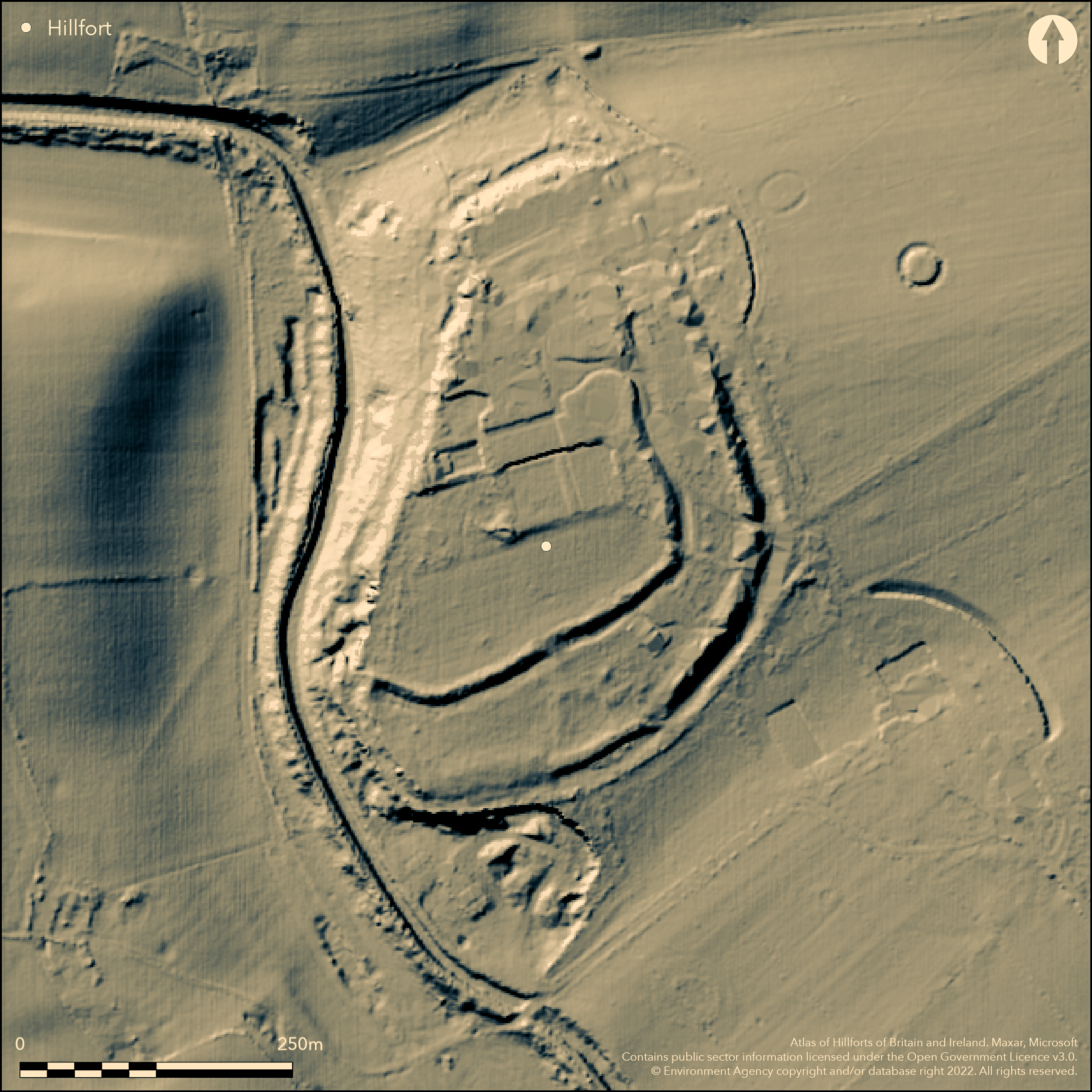
LiDAR 1m DTM Hillshade
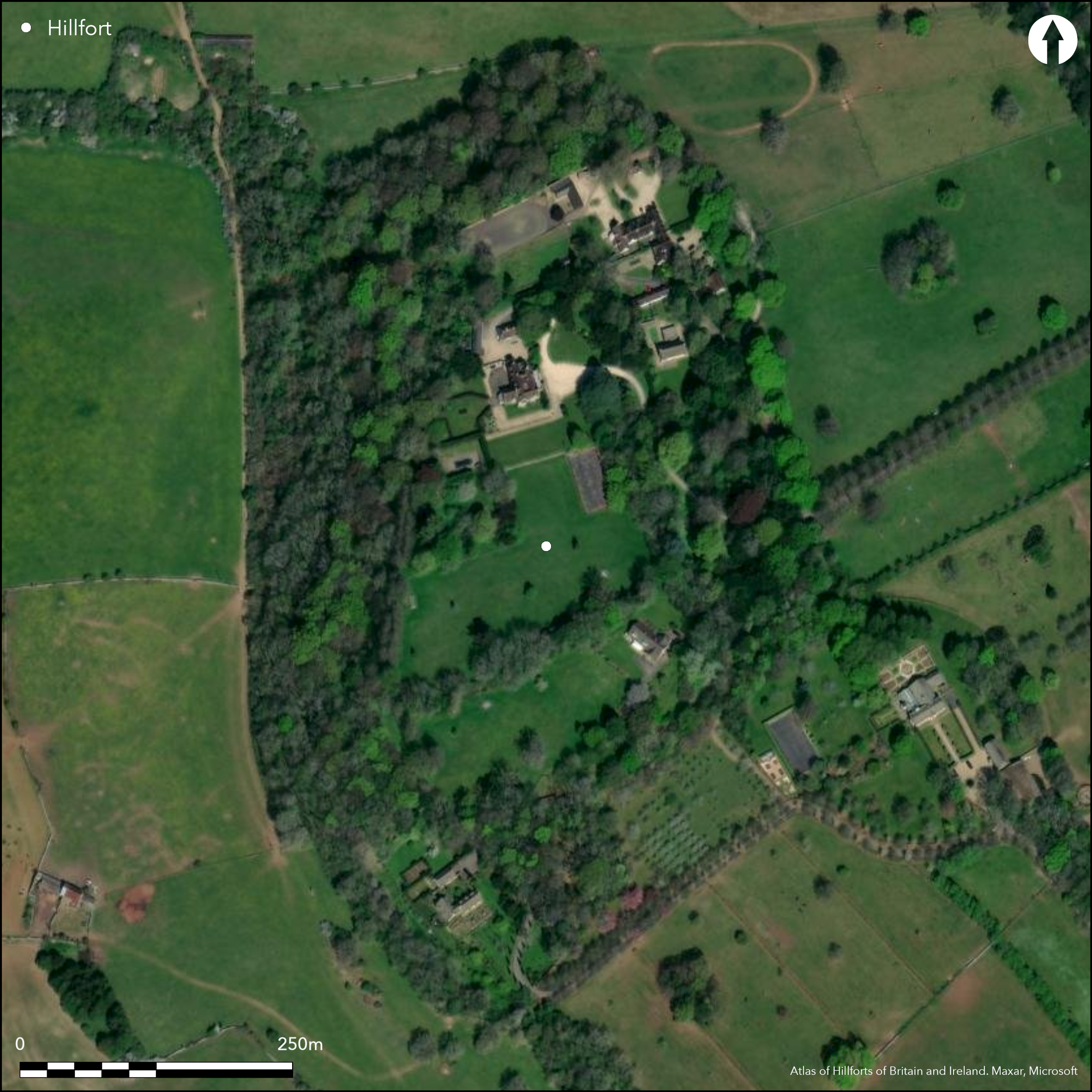
Satellite Imagery
LiDAR 1m DTM Hillshade
Satellite Imagery
Scroll left/right to view further images.
HER: Gloucestershire 2107 (None)
NMR: ST 99 NE 7 (212751)
SM: None
NGR: ST981998
X: 398100 Y: 199800 (OSGB36)
Large, bivallate, complex, contour fort located on a low SW-facing spur on the edge of a shallow valley, just N of Thames Head, source of the River Thames. River Frome to NW. Much affected by development and interior gardens and paddocks. W and N sides much disturbed by development, but on E and S (despite development) two substantial widely-spaced banks, each with outer ditch. Encloses 4.8ha. Inner bank,c. 7m wide by nearly 1m high, with ditch 9m wide and nearly 1m deep. Outer bank, nearly 14m wide and 1.8 m high, with ditch c. 11m wide by just over 1m deep, turns sharply at S point, running NW to join inner bank. Part of low bank without a ditch on NW set between steep W fall of the spur and a secondary scarp. A slighter bank turns inwards from its S end. Large distance between E and S ramparts (to 50m) could suggest phased construction. British gold coin, Roman coins and coarse Romano-British pottery fragments chance finds. No trace of any features in interior. On OS 1' map (1830).
Citizen Science: ✗
Reliability of Data: Confirmed
Reliability of Interpretation: Confirmed
X: -225857 Y: 6745505 (EPSG: 3857)
Longitude: -2.028906027062478 Latitude: 51.696898489768856 (EPSG:4326)
Country: England
Current County or Unitary Authority: Gloucestershire
Historic County: Gloucestershire
Current Parish/Community/Council/Townland: Coates
Much affected by development and interior gardens and paddocks. Complete NE section destroyed by development. Trewsbury House in interior.
| Extant | ✓ |
| Cropmark | ✗ |
| Likely Destroyed | ✓ |
Development, pasture and gardens and wooded in part.
| Woodland | ✓ |
| Commercial Forestry Plantation | ✗ |
| Parkland | ✗ |
| Pasture (Grazing) | ✓ |
| Arable | ✗ |
| Scrub/Bracken | ✓ |
| Bare Outcrop | ✗ |
| Heather/Moorland | ✗ |
| Heath | ✗ |
| Built-up | ✓ |
| Coastal Grassland | ✗ |
| Other | ✗ |
Bivallate contour fort located on a low SW-facing spur on the edge of a shallow valley, just N of Thames Head, source of the River Thames. River Frome to NW.
| Contour Fort | ✓ |
| Partial Contour Fort | ✗ |
| Promontory Fort | ✗ |
| Hillslope Fort | ✗ |
| Level Terrain Fort | ✗ |
| Marsh Fort | ✗ |
| Multiple Enclosure Fort | ✓ |
Located on a spur edge above a shallow valley
| Hilltop | ✗ |
| Coastal Promontory | ✗ |
| Inland Promontory | ✗ |
| Valley Bottom | ✗ |
| Knoll/Hillock/Outcrop | ✗ |
| Ridge | ✗ |
| Cliff/Plateau-edge/Scarp | ✗ |
| Hillslope | ✗ |
| Lowland | ✗ |
| Spur | ✓ |
Dominant Topographic Feature: Spur
| North | ✗ |
| Northeast | ✗ |
| East | ✗ |
| Southeast | ✗ |
| South | ✗ |
| Southwest | ✗ |
| West | ✗ |
| Northwest | ✗ |
| Level | ✓ |
Altitude: 140.0m
N/A
None except for British gold coin, Roman coins and coarse Romano British pottery fragments as surface finds.
Reliability: D - None
| Pre 1200BC | ✗ |
| 1200BC - 800BC | ✗ |
| 800BC - 400BC | ✗ |
| 400BC - AD50 | ✗ |
| AD50 - AD400 | ✗ |
| AD400 - AD 800 | ✗ |
| Post AD800 | ✗ |
| Unknown | ✓ |
| Pre Hillfort: | None |
| Post Hillfort: | None |
On OS 1' map 1830. Aerial photograph interpretation Gloucestershire County Council: Cotswold Hills (S. Cotswolds) NMP, 2007-2010.
| 1st Identified Map Depiction (1830): | OS map. |
| Other (1875): | OS map. |
| Other (None): | Aerial photograph interpretation Gloucestershire County Council. |
Any former interior features obliterated by development. British gold coin, Roman coins and coarse Romano British pottery fragments chance finds.
None
| None | ✓ |
| Spring | ✗ |
| Stream | ✗ |
| Pool | ✗ |
| Flush | ✗ |
| Well | ✗ |
| Other | ✗ |
Any former interior features obliterated by development.
| No Known Features | ✓ |
| Round Stone Structures | ✗ |
| Rectangular Stone Structures | ✗ |
| Curvilinear Platforms | ✗ |
| Other Roundhouse Evidence | ✗ |
| Pits | ✗ |
| Quarry Hollows | ✗ |
| Other | ✗ |
None
| No Known Excavation | ✓ |
| Pits | ✗ |
| Postholes | ✗ |
| Roundhouses | ✗ |
| Rectangular Structures | ✗ |
| Roads/Tracks | ✗ |
| Quarry Hollows | ✗ |
| Other | ✗ |
| Nothing Found | ✗ |
None
| No Known Geophysics | ✓ |
| Pits | ✗ |
| Roundhouses | ✗ |
| Rectangular Structures | ✗ |
| Roads/Tracks | ✗ |
| Quarry Hollows | ✗ |
| Other | ✗ |
| Nothing Found | ✗ |
British gold coin, Roman coins and coarse Romano British pottery fragments chance finds.
| No Known Finds | ✗ |
| Pottery | ✓ |
| Metal | ✗ |
| Metalworking | ✗ |
| Human Bones | ✗ |
| Animal Bones | ✗ |
| Lithics | ✗ |
| Environmental | ✗ |
| Other | ✓ |
None
| APs Not Checked | ✓ |
| None | ✗ |
| Roundhouses | ✗ |
| Rectangular Structures | ✗ |
| Pits | ✗ |
| Postholes | ✗ |
| Roads/Tracks | ✗ |
| Other | ✗ |
Impossible to determine site of original entrance or entrances, two breaks to SE being wholly or partly modern and complete NE portion of the earthwork destroyed. Much development and many modern gaps. But one (or both) of two former possible entrance gaps could be candidates, on N and that on E less certain. But much conjecture.
| 2: | Much development and many modern gaps. |
| 2: | Conjecture only. |
Guard Chambers: ✗
Chevaux de Frise: ✗
| 1. Simple Gap (North): | Conjecture only. |
| 2. Simple Gap (East): | Conjecture only. |
W and N sides much disturbed by development, but on E and S (despite development) two substantial widely-spaced banks, each with outer ditch. Inner bank,c. 7m wide by nearly 1m high, with ditch 9m wide and nearly 1m deep. Outer bank, nearly 14m wide and 1.8 m high, with ditch c. 11m wide by just over 1m deep, turns sharply at S point, running NW to join inner bank. Part of low bank without a ditch on NW set between steep W fall of the spur and a secondary scarp. A slighter bank turns inwards from its S end. Large distance between E and S ramparts (to 50.0m) could suggest phased construction.
| Area 1: | 4.8ha. |
| Total: | 4.8ha. |
Total Footprint Area: Noneha.
None
| ✓ | Large distance between E and S ramparts (to 50m) could suggest phased construction. |
| ✗ | Sections obliterated by development on NE and W. |
| NE Quadrant: | 2 |
| SE Quadrant: | 2 |
| SW Quadrant: | 2 |
| NW Quadrant: | 2 |
| Total: | 2 |
| Partial Univallate | ✗ |
| Univallate | ✗ |
| Partial Bivallate | ✗ |
| Bivallate | ✓ |
| Partial Multivallate | ✗ |
| Multivallate | ✗ |
| Unknown | ✗ |
| Partial Univallate | ✗ |
| Univallate | ✓ |
| Partial Bivallate | ✗ |
| Bivallate | ✗ |
| Partial Multivallate | ✗ |
| Multivallate | ✗ |
None
| None | ✗ |
| Earthen Bank | ✓ |
| Stone Wall | ✗ |
| Rubble | ✗ |
| Wall-walk | ✗ |
| Evidence of Timber | ✗ |
| Vitrification | ✗ |
| Other Burning | ✗ |
| Palisade | ✗ |
| Counter Scarp Bank | ✗ |
| Berm | ✗ |
| Unfinished | ✗ |
| Other | ✗ |
None
| None | ✗ |
| Earthen Bank | ✗ |
| Stone Wall | ✗ |
| Murus Duplex | ✗ |
| Timber-framed | ✗ |
| Timber-laced | ✗ |
| Vitrification | ✗ |
| Other Burning | ✗ |
| Palisade | ✗ |
| Counter Scarp Bank | ✗ |
| Berm | ✗ |
| Unfinished | ✗ |
| No Known Excavation | ✓ |
| Other | ✗ |
| ✗ | None |
| ✓ | Wide ditches. |
Number of Ditches: 2
| ✗ | None |
RCHME 1976. Ancient and historical monuments in the County of Gloucestershire, Vol. I: Iron Age and Romano- British monuments in Gloucestershire Cotswolds, London: HMSO, 32.
Saville, A. ed 1984. Archaeology in Gloucestershire from earliest hunters to the industrial age: essays dedicated to Helen O'Neil and the late Elsie Clifford, 165.
Atlas of Hillforts:
Wikidata:
This work is licensed under CC BY-SA 4.0

 and should be cited as:
Lock, Gary and Ralston, Ian. 2024. Atlas of Hillforts of Britain and Ireland. Available at: https://hillforts.arch.ox.ac.uk
Document Version 1.1