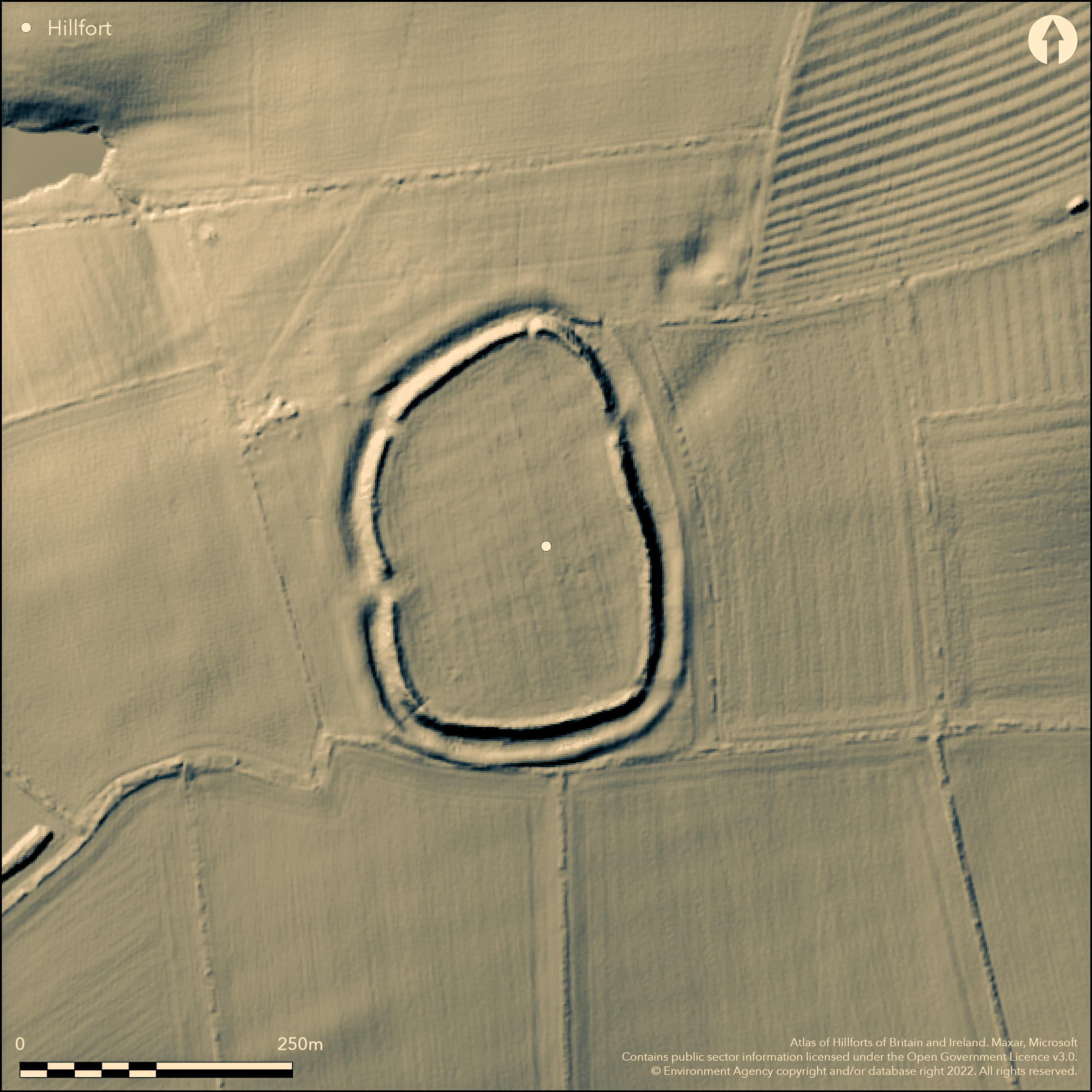
LiDAR 1m DTM Hillshade
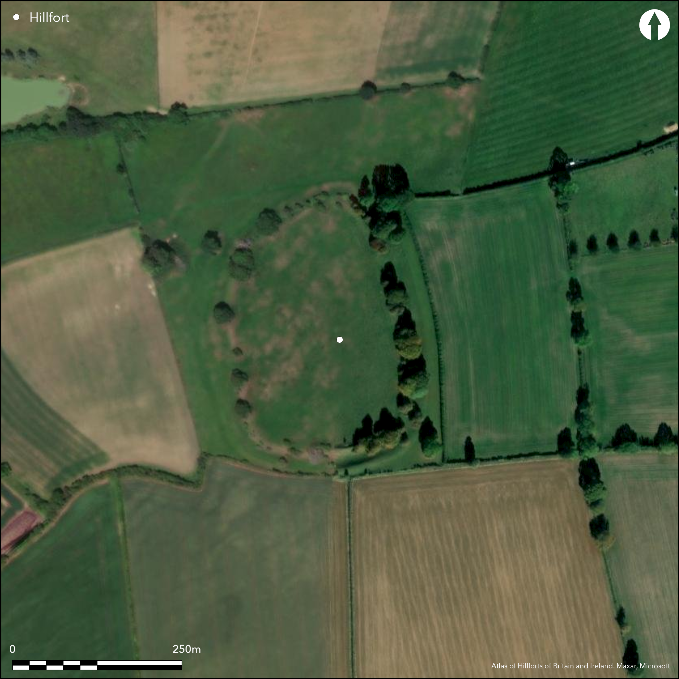
Satellite Imagery
LiDAR 1m DTM Hillshade
Satellite Imagery
Scroll left/right to view further images.
HER: Northamptonshire 57/1 (MNN138378)
NMR: SP 5 3 SW 11 (339180)
SM: 1003914
NGR: SP 5263 3483
X: 452634 Y: 234835 (OSGB36)
Just S of Charlton village, a partial contour fort of on a plateau top, overlooking the Cherwell Valley to the W, now under pasture with some trees and shrubs on the ramparts. On 1st Ed OS map (1885-1900), excavations and geophysics in 1961-5 (Avery et. al. 1967). Bivallate with two ditches for entire circuit, enclosing 2.6ha. Inner bank up to 3m high with outer ditch c. 4m deep. Outer bank reduced by cultivation to 0.5m high and completely gone on the E, up to 1m high to S. Outer ditch has gone completely except for slight traces along W side. The main inner rampart has a dry-stone outer face , still 0.75m high in places, visible for long lengths presumably originally continuous around whole circuit although this may be medieval (RCHME 1982). A single complex entrance to the W. The following sequence is based on pottery and stratigraphy as suggested by Avery and roughly supported by later C14 dates and archaeomagnetic dating (Clelland and Batt 2010): EIA1 (6th/5th centuries BC?): possible first phase univallate enclosure, the remaining outer bank and ditch, some occupation. EIA2a 5th century BC?): bi-vallate construction, inner rampart 3-tiered wall construction, outer was turf/limestone dump. V-shaped ditches, inner 4m deep and 6m wide, outer 4m deep unknown width. Entrance in-turned with C-shaped guard rooms, passageway 4m wide and 20m long, woodlined, 'sentry boxes', cobbled roadway. EIA 2b (early 4th century BC?): occupation, minor changes to entrance. EIA 3a (early 4th century BC?): deliberate? burning and destruction of ramparts and entrance. EIA 4 (late 2nd century BC?): ramparts rebuilt as dump, U-shaped ditches, inner 13m wide and 3m deep, outer 8m wide and 3m deep. Some re-modelling of the entrance. RB 1 (late 1st century AD?): small-scale occupation? RB 2 (late 4th century AD?): small stone building at outer end of entrance, road re-modelled Possible 18th century: landscaping including walling around the outer face of the inner rampart
Citizen Science: ✓
Reliability of Data: Confirmed
Reliability of Interpretation: Confirmed
X: -137432 Y: 6801829 (EPSG: 3857)
Longitude: -1.2345706598246742 Latitude: 52.009418746164584 (EPSG:4326)
Country: England
Current County or Unitary Authority: Northamptonshire
Historic County: Northamptonshire
Current Parish/Community/Council/Townland: Charlton
None
| Extant | ✓ |
| Cropmark | ✗ |
| Likely Destroyed | ✗ |
None
| Woodland | ✗ |
| Commercial Forestry Plantation | ✗ |
| Parkland | ✗ |
| Pasture (Grazing) | ✓ |
| Arable | ✗ |
| Scrub/Bracken | ✓ |
| Bare Outcrop | ✗ |
| Heather/Moorland | ✗ |
| Heath | ✗ |
| Built-up | ✗ |
| Coastal Grassland | ✗ |
| Other | ✗ |
A partial contour fort on a plateau top, overlooking the Cherwell Valley to the W.
| Contour Fort | ✗ |
| Partial Contour Fort | ✓ |
| Promontory Fort | ✗ |
| Hillslope Fort | ✗ |
| Level Terrain Fort | ✗ |
| Marsh Fort | ✗ |
| Multiple Enclosure Fort | ✗ |
| Hilltop | ✓ |
| Coastal Promontory | ✗ |
| Inland Promontory | ✗ |
| Valley Bottom | ✗ |
| Knoll/Hillock/Outcrop | ✗ |
| Ridge | ✗ |
| Cliff/Plateau-edge/Scarp | ✗ |
| Hillslope | ✗ |
| Lowland | ✗ |
| Spur | ✗ |
Dominant Topographic Feature: Views across the Cherwell valley
| North | ✗ |
| Northeast | ✗ |
| East | ✗ |
| Southeast | ✗ |
| South | ✗ |
| Southwest | ✗ |
| West | ✗ |
| Northwest | ✗ |
| Level | ✓ |
Altitude: 147.0m
N/A
The following sequence is based on pottery and stratigraphy as suggested by Avery and roughly supported by later C14 dates and archaeomagnetic dating (Clelland and Batt 2010): EIA1 (6th/5th centuries BC?): possible first phase univallate enclosure, the remaining outer bank and ditch, some occupation. EIA2a 5th century BC?): bi-vallate construction, inner rampart 3-tiered wall construction, outer was turf/limestone dump. V-shaped ditches, inner 4m deep and 6m wide, outer 4m deep unknown width. Entrance in-turned with C-shaped guard rooms, passageway 4m wide and 20m long, woodlined, 'sentry boxes', cobbled roadway. EIA 2b (early 4th century BC?): occupation, minor changes to entrance. EIA 3a (early 4th century BC?): deliberate? burning and destruction of ramparts and entrance. EIA 4 (late 2nd century BC?): ramparts rebuilt as dump, U-shaped ditches, inner 13m wide and 3m deep, outer 8m wide and 3m deep. Some re-modelling of the entrance. RB 1 (late 1st century AD?): small-scale occupation? RB 2 (late 4th century AD?): small stone building at outer end of entrance, road re-modelled Possible 18th century: landscaping including walling around the outer face of the inner rampart
Reliability: A - High
| Pre 1200BC | ✗ |
| 1200BC - 800BC | ✗ |
| 800BC - 400BC | ✓ |
| 400BC - AD50 | ✓ |
| AD50 - AD400 | ✗ |
| AD400 - AD 800 | ✗ |
| Post AD800 | ✗ |
| Unknown | ✗ |
| Pre Hillfort: | None |
| Post Hillfort: | None |
| Artefactual: | None |
| C14: | None |
| Other: | archaeomagnetic |
On 1st Ed OS map (1885-1900), mentioned in Beesley (1841), excavations and geophysics in 1961-5 (Avery et. al. 1967).
| 1st Identified Written Reference (1841): | None |
| 1st Identified Map Depiction (None): | None |
| Geophysical Survey (None): | None |
| Excavation (None): | None |
Pits, postholes and roundhouse gullies shown by limited excavation in the interior, geophysics showed pits, gullies and hearths. Finds of pottery, human bones and animal bones.
Springs 300m away down slope from site
| None | ✓ |
| Spring | ✗ |
| Stream | ✗ |
| Pool | ✗ |
| Flush | ✗ |
| Well | ✗ |
| Other | ✗ |
None
| No Known Features | ✓ |
| Round Stone Structures | ✗ |
| Rectangular Stone Structures | ✗ |
| Curvilinear Platforms | ✗ |
| Other Roundhouse Evidence | ✗ |
| Pits | ✗ |
| Quarry Hollows | ✗ |
| Other | ✗ |
Hollows for industrial? use
| No Known Excavation | ✗ |
| Pits | ✓ |
| Postholes | ✓ |
| Roundhouses | ✓ |
| Rectangular Structures | ✗ |
| Roads/Tracks | ✗ |
| Quarry Hollows | ✗ |
| Other | ✓ |
| Nothing Found | ✗ |
gullies and hearths
| No Known Geophysics | ✗ |
| Pits | ✓ |
| Roundhouses | ✗ |
| Rectangular Structures | ✗ |
| Roads/Tracks | ✗ |
| Quarry Hollows | ✗ |
| Other | ✓ |
| Nothing Found | ✗ |
None
| No Known Finds | ✗ |
| Pottery | ✓ |
| Metal | ✗ |
| Metalworking | ✗ |
| Human Bones | ✓ |
| Animal Bones | ✓ |
| Lithics | ✗ |
| Environmental | ✗ |
| Other | ✗ |
NO APPARENT FEATURES
| APs Not Checked | ✓ |
| None | ✗ |
| Roundhouses | ✗ |
| Rectangular Structures | ✗ |
| Pits | ✗ |
| Postholes | ✗ |
| Roads/Tracks | ✗ |
| Other | ✗ |
Five breaks through the rampart but one original entrance to the W. EIA 2a - in-turned with C-shaped guard rooms, passageway 4m wide and 20m long, woodlined, 'sentry boxes', cobbled roadway. Destroyed in EIA3a, some reconstruction in EIA 4. Two breaks (N and NW) dated to 17th century, E may be Roman (RCHME).
| 5: | None |
| 2: | None |
Guard Chambers: ✓
Chevaux de Frise: ✗
| 1. In-turned (West): | None |
Bivallate, two ditches. EIA 2a: inner rampart 3-tiered wall construction, outer was turf/limestone dump. V-shaped ditches, inner 4m deep and 6m wide, outer 4m deep unknown width. EIA 4: ramparts rebuilt as dump, U-shaped ditches, inner 13m wide and 3m deep, outer 8m wide and 3m deep.
| Area 1: | 2.6ha. |
| Total: | 2.6ha. |
Total Footprint Area: Noneha.
None
| ✗ | None |
| ✓ | None |
| NE Quadrant: | 2 |
| SE Quadrant: | 2 |
| SW Quadrant: | 2 |
| NW Quadrant: | 2 |
| Total: | 2 |
| Partial Univallate | ✗ |
| Univallate | ✗ |
| Partial Bivallate | ✗ |
| Bivallate | ✓ |
| Partial Multivallate | ✗ |
| Multivallate | ✗ |
| Unknown | ✗ |
| Partial Univallate | ✗ |
| Univallate | ✗ |
| Partial Bivallate | ✗ |
| Bivallate | ✗ |
| Partial Multivallate | ✗ |
| Multivallate | ✗ |
None
| None | ✗ |
| Earthen Bank | ✓ |
| Stone Wall | ✗ |
| Rubble | ✗ |
| Wall-walk | ✗ |
| Evidence of Timber | ✗ |
| Vitrification | ✗ |
| Other Burning | ✗ |
| Palisade | ✗ |
| Counter Scarp Bank | ✗ |
| Berm | ✗ |
| Unfinished | ✗ |
| Other | ✗ |
None
| None | ✗ |
| Earthen Bank | ✓ |
| Stone Wall | ✓ |
| Murus Duplex | ✗ |
| Timber-framed | ✗ |
| Timber-laced | ✗ |
| Vitrification | ✗ |
| Other Burning | ✗ |
| Palisade | ✗ |
| Counter Scarp Bank | ✗ |
| Berm | ✗ |
| Unfinished | ✗ |
| No Known Excavation | ✗ |
| Other | ✗ |
| ✗ | None |
| ✓ | None |
Number of Ditches: 2
| ✗ | None |
Avery, M., Sutton, J. and Banks, J. 1967. Rainsborough, Northants, England: Excavations 1961-5. Proc Prehist Soc XXXIII, 207-306.
Beesley, A. 1841. The history of Banbury: including copious historical and antiquarian notices of the neighbourhood.
Clelland, S-J. and Batt, C.M. 2010. A re-investigation of the scientific dating evidence from the hillfort at Rainsborough. Northamptonshire Archaeol. 36, 1-7.
RCHME. 1982. An inventory of the Historical Monuments in the county of Northampton, 4, An inventory of Archaeological sites in South-West Northamptonshire. Royal Commission on Historical Monuments England, London, HMSO.
Atlas of Hillforts:
Wikidata:
This work is licensed under CC BY-SA 4.0

 and should be cited as:
Lock, Gary and Ralston, Ian. 2024. Atlas of Hillforts of Britain and Ireland. Available at: https://hillforts.arch.ox.ac.uk
Document Version 1.1