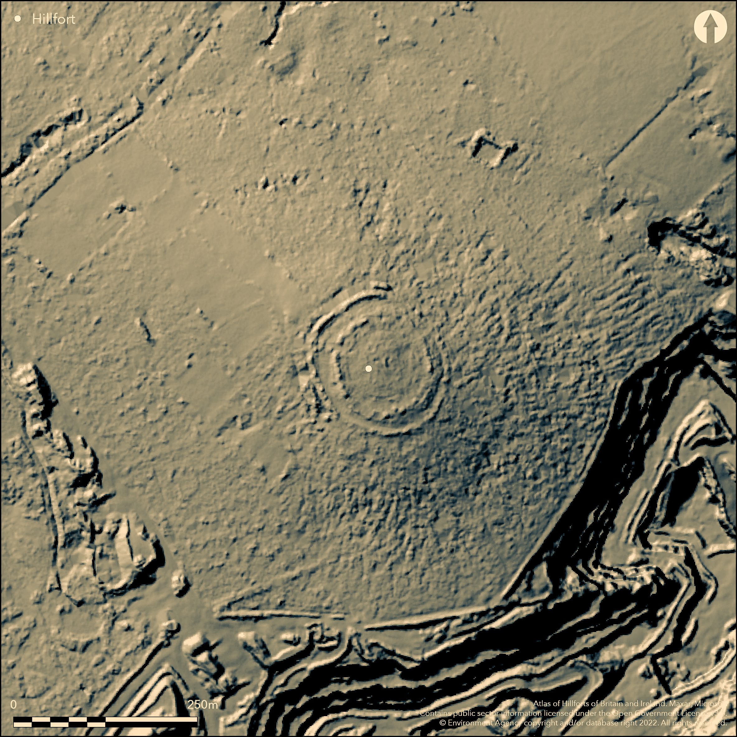
LiDAR 1m DTM Hillshade
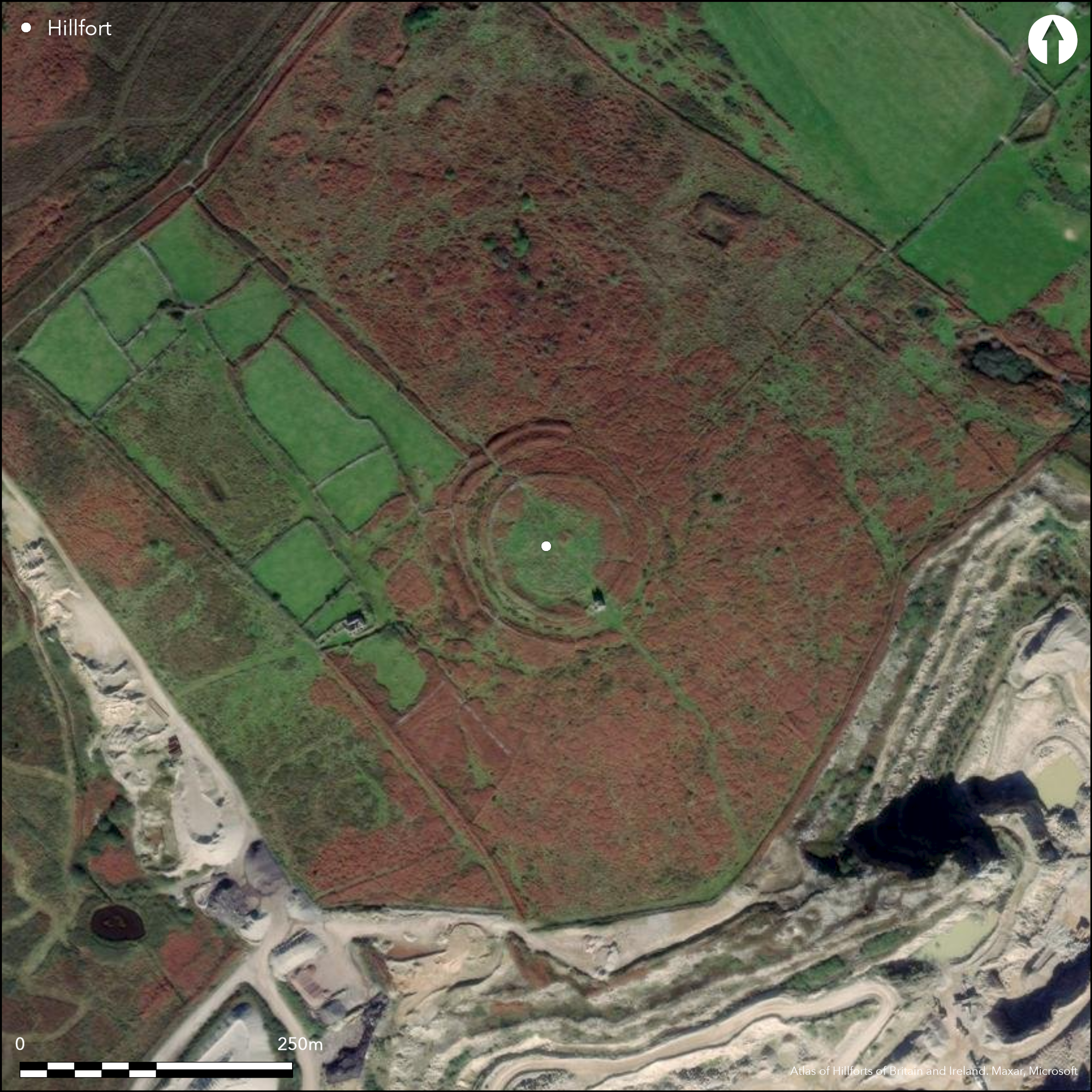
Satellite Imagery
LiDAR 1m DTM Hillshade
Satellite Imagery
Scroll left/right to view further images.
HER: Cornwall and Scilly 31588 (None)
NMR: SW 43 NE 32 (423254)
SM: 1006725
NGR: SW 48487 35009
X: 148487 Y: 35009 (OSGB36)
Possible multiple enclosure site, originally a stone-built contour hillfort, located on the summit of hill on Tonkins Downs. Moderate to steep surrounding slopes, less so on broad ridge to NW, W and S. Site almost circular with four, concentric, widely-spaced ramparts and partially buried outer ditch. Inner rampart, now low tumbled stone bank and least preserved, predominantly to S and SE, but can be traced around circuit. Second rampart has ruined stony wall, almost complete around circuit, with remains of outer retaining wall to 1.8m high in places. Third rampart of earth and stones and used as present field boundary, but almost complete. Fourth line, and outer defence, to 2.3m high of similar construction, strongest, only extending from SW to N, with largely buried outer ditch for most of its length, and faces the most vulnerable approach to the site. No evidence that it completed the circuit. Enclosed areas 0.45ha inner and 1.17ha outer. Gaps in two places - to SW, with possible out-turn, but this could be result of later digging. Second gap, to W, also out-turned from next inner rampart, possible original entrance, but mutilation problem here. No complementary gaps in remaining inner ramparts. Other gaps to SE probably modern as result of 18th century tower and track to it. In SE quadrant the square 18th century folly has four corner turrets, called 'Roger's Tower' and associated with John Rogers of Treassowe 1750-1832, built from second rampart stone. The hillfort first recorded by W. Borlase 1769, with circular 7m diameter features enclosed by rubble walls in interior: no longer visible. On 1st Ed. OS map (1878). Undated.
Citizen Science: ✗
Reliability of Data: Confirmed
Reliability of Interpretation: Confirmed
X: -614819 Y: 6474304 (EPSG: 3857)
Longitude: -5.523014778622671 Latitude: 50.16156949112706 (EPSG:4326)
Country: England; None
Current County or Unitary Authority: Cornwall
Historic County: Cornwall
Current Parish/Community/Council/Townland: Ludgvan; Madron
18th century folly with track located in interior. On Heritage at Risk Register (2015).
| Extant | ✓ |
| Cropmark | ✗ |
| Likely Destroyed | ✗ |
Grassland with folly.
| Woodland | ✗ |
| Commercial Forestry Plantation | ✗ |
| Parkland | ✗ |
| Pasture (Grazing) | ✓ |
| Arable | ✗ |
| Scrub/Bracken | ✗ |
| Bare Outcrop | ✗ |
| Heather/Moorland | ✗ |
| Heath | ✗ |
| Built-up | ✓ |
| Coastal Grassland | ✗ |
| Other | ✗ |
Possible multiple enclosure site, originally a stone-built contour hillfort, located on the summit of hill on Tonkins Downs. Moderate to steep surrounding slopes, less so on broad ridge to NW, W and S.
| Contour Fort | ✓ |
| Partial Contour Fort | ✗ |
| Promontory Fort | ✗ |
| Hillslope Fort | ✗ |
| Level Terrain Fort | ✗ |
| Marsh Fort | ✗ |
| Multiple Enclosure Fort | ✓ |
| Hilltop | ✓ |
| Coastal Promontory | ✗ |
| Inland Promontory | ✗ |
| Valley Bottom | ✗ |
| Knoll/Hillock/Outcrop | ✗ |
| Ridge | ✗ |
| Cliff/Plateau-edge/Scarp | ✗ |
| Hillslope | ✗ |
| Lowland | ✗ |
| Spur | ✗ |
Dominant Topographic Feature: Summit of broad hill.
| North | ✗ |
| Northeast | ✗ |
| East | ✗ |
| Southeast | ✗ |
| South | ✗ |
| Southwest | ✗ |
| West | ✗ |
| Northwest | ✗ |
| Level | ✓ |
Altitude: 228.0m
Parish boundary close by
Boundary Type: Parish/Townland
None.
Reliability: D - None
| Pre 1200BC | ✗ |
| 1200BC - 800BC | ✗ |
| 800BC - 400BC | ✗ |
| 400BC - AD50 | ✗ |
| AD50 - AD400 | ✗ |
| AD400 - AD 800 | ✗ |
| Post AD800 | ✗ |
| Unknown | ✓ |
| Pre Hillfort: | None |
| Post Hillfort: | Gaps to SE probably modern as result of 18th century tower and track to it. In SE quadrant the square 18th century folly has four corner turrets, called 'Roger's Tower' and associated with John Rogers of Treassowe 1750-1832, built from second rampart stone. |
Hillfort first recorded by W. Borlase 1769. On 1st Ed. OS map (1878). Field investigations Ordnance Survey 1960, 1975. Watching Brief Cornwall County Council 2002-03. Geophysical survey University of Durham 2004. Desk assessment Cornwall County Council, 2011.
| 1st Identified Written Reference (1769): | Recorded by W. Borlase. |
| 1st Identified Map Depiction (1878): | OS map. |
| Geophysical Survey (2004): | University of Durham Archaeological Services. |
| Other (2011): | Desk assessment Cornwall County Council. |
| Other (None): | Watching Brief Cornwall County Council |
First recorded by Borlase 1769 18th century who described circular 7m diameter features enclosed by rubble walls in interior (possibly roundhouses). Now no longer visible but may remain beneath surface. Geophysical survey 2004 - no details. Two stone weights, two swords and a ring - weights now in Truro Museum.
None
| None | ✓ |
| Spring | ✗ |
| Stream | ✗ |
| Pool | ✗ |
| Flush | ✗ |
| Well | ✗ |
| Other | ✗ |
First recorded by Borlase 1769 18th century with circular 7m diameter features enclosed by rubble walls in interior (possibly roundhouses). Now no longer visible, but may remain beneath surface.
| No Known Features | ✗ |
| Round Stone Structures | ✓ |
| Rectangular Stone Structures | ✗ |
| Curvilinear Platforms | ✗ |
| Other Roundhouse Evidence | ✗ |
| Pits | ✗ |
| Quarry Hollows | ✗ |
| Other | ✗ |
None
| No Known Excavation | ✓ |
| Pits | ✗ |
| Postholes | ✗ |
| Roundhouses | ✗ |
| Rectangular Structures | ✗ |
| Roads/Tracks | ✗ |
| Quarry Hollows | ✗ |
| Other | ✗ |
| Nothing Found | ✗ |
Geophysical survey 2004 - no details.
| No Known Geophysics | ✗ |
| Pits | ✗ |
| Roundhouses | ✗ |
| Rectangular Structures | ✗ |
| Roads/Tracks | ✗ |
| Quarry Hollows | ✗ |
| Other | ✓ |
| Nothing Found | ✗ |
Two stone weights, two swords and a ring-weights, now in Truro Museum.
| No Known Finds | ✗ |
| Pottery | ✗ |
| Metal | ✓ |
| Metalworking | ✗ |
| Human Bones | ✗ |
| Animal Bones | ✗ |
| Lithics | ✓ |
| Environmental | ✗ |
| Other | ✗ |
None
| APs Not Checked | ✓ |
| None | ✗ |
| Roundhouses | ✗ |
| Rectangular Structures | ✗ |
| Pits | ✗ |
| Postholes | ✗ |
| Roads/Tracks | ✗ |
| Other | ✗ |
Gaps in two places - to SW, with possible out-turn, but this could be result of later digging. Second gap, to W, also out-turned from next inner rampart, possible original entrance, but mutilation problem here. No complementary gaps in remaining inner ramparts. Other gaps to SE probably modern as result of 18th century tower and track to it.
| 3: | Gap(s) on SE probably modern as result of track to tower. |
| 2: | Possibly only one entrance - on W. |
Guard Chambers: ✗
Chevaux de Frise: ✗
| 1. Simple Gap (South west): | Doubts on this entrance as out-turn possibly result of later digging. |
| 2. Out-turned (West): | Possible. |
Site almost circular with four concentric widely-spaced ramparts and partially buried outer ditch. Inner rampart, now low tumbled stone bank and least preserved, predominantly to S and SE, but can be traced around circuit. Second rampart ruined stony wall, almost complete around circuit, with remains of outer retaining wall to 1.8m high in places. Third rampart of earth and stones and used as present field boundary, but almost complete. Fourth line, and outer defence, to 2.3m high of similar construction, strongest, only extending from SW to N, with largely buried outer ditch for most of its length, and faces the most vulnerable approach to the site. No evidence that it completed the circuit. Possibly phased?
| Area 1: | 0.45ha. |
| Area 2: | 1.17ha. |
| Total: | 1.17ha. |
Total Footprint Area: Noneha.
None
| ✓ | Possibly phased, as thought originally stone contour fort. |
| ✓ | Three or four ramparts. Possible multi phased. |
| NE Quadrant: | 3 |
| SE Quadrant: | 3 |
| SW Quadrant: | 4 |
| NW Quadrant: | 4 |
| Total: | 4 |
| Partial Univallate | ✗ |
| Univallate | ✗ |
| Partial Bivallate | ✗ |
| Bivallate | ✗ |
| Partial Multivallate | ✗ |
| Multivallate | ✓ |
| Unknown | ✗ |
| Partial Univallate | ✗ |
| Univallate | ✓ |
| Partial Bivallate | ✗ |
| Bivallate | ✗ |
| Partial Multivallate | ✗ |
| Multivallate | ✗ |
None
| None | ✗ |
| Earthen Bank | ✓ |
| Stone Wall | ✓ |
| Rubble | ✓ |
| Wall-walk | ✗ |
| Evidence of Timber | ✗ |
| Vitrification | ✗ |
| Other Burning | ✗ |
| Palisade | ✗ |
| Counter Scarp Bank | ✗ |
| Berm | ✗ |
| Unfinished | ✗ |
| Other | ✗ |
None
| None | ✗ |
| Earthen Bank | ✗ |
| Stone Wall | ✗ |
| Murus Duplex | ✗ |
| Timber-framed | ✗ |
| Timber-laced | ✗ |
| Vitrification | ✗ |
| Other Burning | ✗ |
| Palisade | ✗ |
| Counter Scarp Bank | ✗ |
| Berm | ✗ |
| Unfinished | ✗ |
| No Known Excavation | ✓ |
| Other | ✗ |
| ✗ | None |
| ✓ | Partially-buried outer ditch. |
Number of Ditches: 1
| ✗ | None |
Borlase, W. 1769. The antiquities of Cornwall, London: W. Bowyer and J. Nichols, 346-47.
Cripps, L.J. 2004. Castle-an-Dinas, Ludgvan, Nr. Penzance. Geophysical Survey, Archaeological Services, University of Durham.
Jones, A. 2004. Castle an Dinas, Ludgvan, Cornwall: conservation work to Rogers Tower and ruined 19th century farmhouse, Unpublished Report No 04R010, Cornwall Archaeological Unit, Cornwall County Council.
Page, W. ed. 1906. The Victoria History of the County of Cornwall, 1, London: James Street, 459, 461.
Parkes, C. 2012. Castle an Dinas Quarry, Ludgvan, Cornwall: archaeological assessment, Report No 11R094, Cornwall Archaeological Unit, Cornwall County Council.
Atlas of Hillforts:
Wikidata:
This work is licensed under CC BY-SA 4.0

 and should be cited as:
Lock, Gary and Ralston, Ian. 2024. Atlas of Hillforts of Britain and Ireland. Available at: https://hillforts.arch.ox.ac.uk
Document Version 1.1