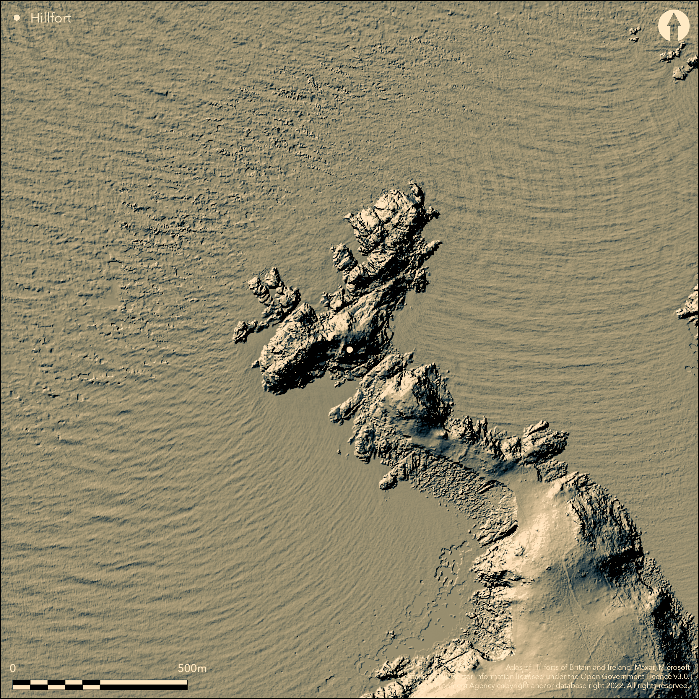
LiDAR 1m DTM Hillshade
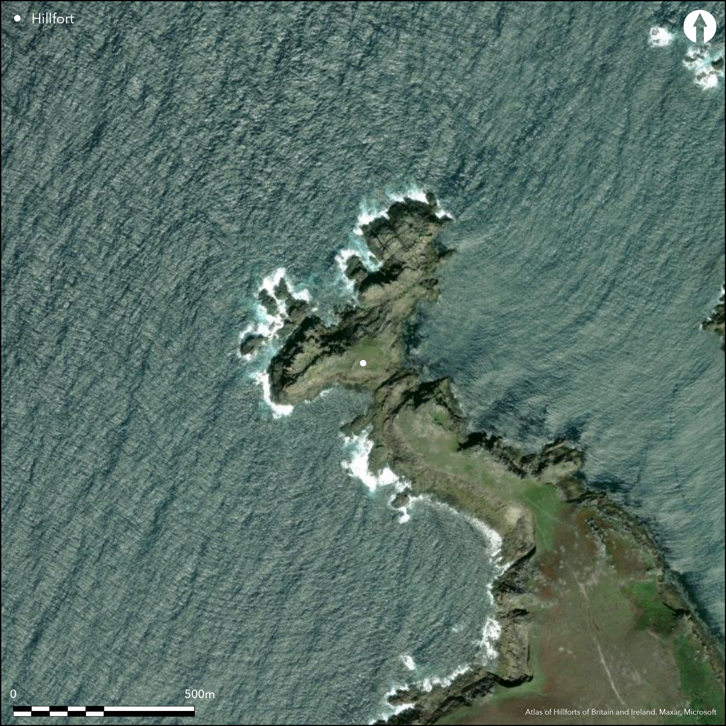
Satellite Imagery
LiDAR 1m DTM Hillshade
Satellite Imagery
Scroll left/right to view further images.
HER: Cornwall and Scilly MCO31251 (7276)
NMR: SV 81 NE 12 (303354)
SM: 1016174
NGR: SV874162
X: 87412 Y: 16268 (OSGB36)
Promontory fort sited on Shipman Head and Badplace HIll, rocky NW-facing headland of Bryher, Isles of Scilly. Hell Bay to SW. Steep natural sea cliffs to N, E and SW, moderate to flat to S where promontory inked to mainland. Area not defined. Two widely-seperated ramparts, 260m apart, cut across headland and divide site into two areas of similar size: one on most of Shipman Head promontory, to NW, other centred on Badplace Hill to SE, separated by inter-tidal channel. To SE a NE-SW rampart defines edge site, visible for c. 51m, from shallow saddle of Great Bottom landwards and runs down steep rocky slope promontory's SW coast from high rocky outcrops of Boat Carn on NE coast. This heaped rubble bank measures 6m-10m across and 0.9m high with larger granite slabs and boulders and massive natural boulders to SW. Raised central part to rampart 4m wide defined by edge-faced slabs, continuous on SE and intermittent on NW side to 0.8m max. Pollen analysis shows early soil layer beneath rampart. NW rampart ENE-WSW across E tip of Shipman Head and separated now from Badplace Hill by the precipitous inter-tidal channel (The Gulf), so dividing the site in the two entities that were probably joined in prehistory as one site. Rampart shows as a slightly curving bank of heaped rubble, c. 30m long, 6m wide and to 0.75m high. Possible narrow entrance with guard chamber has been suggested, but cannot be confirmed. Coastal grassland and bare rock. Coastal erosion has reduced the site. On 1st Ed. OS 25-inch map (1889-90). Undated.
Citizen Science: ✗
Reliability of Data: Confirmed
Reliability of Interpretation: Confirmed
X: -708048 Y: 6440123 (EPSG: 3857)
Longitude: -6.360507683374926 Latitude: 49.964460574270234 (EPSG:4326)
Country: England
Current County or Unitary Authority: Isles of Scilly
Historic County: Cornwall
Current Parish/Community/Council/Townland: Bryher
Western wall and interior much reduced and site now in two distinct entities as result of coastal erosion.
| Extant | ✓ |
| Cropmark | ✗ |
| Likely Destroyed | ✗ |
Coastal grassland and bare rock.
| Woodland | ✗ |
| Commercial Forestry Plantation | ✗ |
| Parkland | ✗ |
| Pasture (Grazing) | ✗ |
| Arable | ✗ |
| Scrub/Bracken | ✗ |
| Bare Outcrop | ✗ |
| Heather/Moorland | ✗ |
| Heath | ✗ |
| Built-up | ✗ |
| Coastal Grassland | ✓ |
| Other | ✗ |
Promontory fort sited on Shipman Head, rocky NW-facing headland of Bryher, Isles of Scilly. Hell Bay to SW.
| Contour Fort | ✗ |
| Partial Contour Fort | ✗ |
| Promontory Fort | ✓ |
| Hillslope Fort | ✗ |
| Level Terrain Fort | ✗ |
| Marsh Fort | ✗ |
| Multiple Enclosure Fort | ✗ |
| Hilltop | ✗ |
| Coastal Promontory | ✓ |
| Inland Promontory | ✗ |
| Valley Bottom | ✗ |
| Knoll/Hillock/Outcrop | ✗ |
| Ridge | ✗ |
| Cliff/Plateau-edge/Scarp | ✗ |
| Hillslope | ✗ |
| Lowland | ✗ |
| Spur | ✗ |
Dominant Topographic Feature: Coastal headland.
| North | ✗ |
| Northeast | ✗ |
| East | ✗ |
| Southeast | ✗ |
| South | ✗ |
| Southwest | ✗ |
| West | ✗ |
| Northwest | ✗ |
| Level | ✓ |
Altitude: 36.0m
N/A
None.
Reliability: D - None
| Pre 1200BC | ✗ |
| 1200BC - 800BC | ✗ |
| 800BC - 400BC | ✗ |
| 400BC - AD50 | ✗ |
| AD50 - AD400 | ✗ |
| AD400 - AD 800 | ✗ |
| Post AD800 | ✗ |
| Unknown | ✓ |
| Pre Hillfort: | Two Bronze Age kerbed cairns located on Badplace Hill in interior and small ring cairn outside outer rampart. |
| Post Hillfort: | None |
On 1st Ed. OS map (1889-90). Field investigation Ordnance Survey 1978. No excavations, but pollen analysis of SE rampart cliff face.
| Other (1978): | Field investigation OS. |
| 1st Identified Map Depiction (None): | OS map. |
| Other (None): | Pollen analysis - no details. |
Traces of hut platforms.
None
| None | ✓ |
| Spring | ✗ |
| Stream | ✗ |
| Pool | ✗ |
| Flush | ✗ |
| Well | ✗ |
| Other | ✗ |
Traces of hut platforms.
| No Known Features | ✗ |
| Round Stone Structures | ✗ |
| Rectangular Stone Structures | ✗ |
| Curvilinear Platforms | ✓ |
| Other Roundhouse Evidence | ✗ |
| Pits | ✗ |
| Quarry Hollows | ✗ |
| Other | ✗ |
None
| No Known Excavation | ✓ |
| Pits | ✗ |
| Postholes | ✗ |
| Roundhouses | ✗ |
| Rectangular Structures | ✗ |
| Roads/Tracks | ✗ |
| Quarry Hollows | ✗ |
| Other | ✗ |
| Nothing Found | ✗ |
None
| No Known Geophysics | ✓ |
| Pits | ✗ |
| Roundhouses | ✗ |
| Rectangular Structures | ✗ |
| Roads/Tracks | ✗ |
| Quarry Hollows | ✗ |
| Other | ✗ |
| Nothing Found | ✗ |
Pollen analysis shows early soil layer beneath rampart.
| No Known Finds | ✗ |
| Pottery | ✗ |
| Metal | ✗ |
| Metalworking | ✗ |
| Human Bones | ✗ |
| Animal Bones | ✗ |
| Lithics | ✗ |
| Environmental | ✗ |
| Other | ✗ |
None
| APs Not Checked | ✓ |
| None | ✗ |
| Roundhouses | ✗ |
| Rectangular Structures | ✗ |
| Pits | ✗ |
| Postholes | ✗ |
| Roads/Tracks | ✗ |
| Other | ✗ |
Possible narrow entrance with guard chamber has been suggested, but cannot be confirmed.
| 1: | None |
| 2: | Entrance cannot be confirmed. |
Guard Chambers: ✓
Chevaux de Frise: ✗
| 1. Simple Gap (South east): | None |
| 1. Recesses/Guard Chambers (South east): | Possible narrow entrance with guard chamber has been suggested, but cannot be confirmed. |
Two widely-seperated ramparts, 260m apart, cut across headland and divide site into two areas of similar size: one on most of Shipman Head promontory, to NW, other centred on Badplace Hill to SE. To SE a NE-SW rampart defines edge site, visible for c. 51m, from shallow saddle of Great Bottom landwards and runs down steep rocky slope promontory's SW coast from high rocky outcrops of Boat Carn on NE coast. This heaped rubble bank measures 6m-10m across and 0.9m high with larger granite slabs and boulders and massive natural boulders to SW. Raised central part to rampart 4m wide defined by edge-faced slabs, continuous on SE and intermittent on NW side to 0.8m max.
| Area 1: | 4.1ha. |
| Area 2: | 6.5ha. |
| Total: | 6.5ha. |
Total Footprint Area: Noneha.
None
| ✗ | Area not wholly defined. Shipman Head survives to a max of c. 4.2 ha, the area around Badplace Hill c. 2.4ha, totalling 6.5.(IR) |
| ✗ | None |
| NE Quadrant: | 0 |
| SE Quadrant: | 2 |
| SW Quadrant: | 0 |
| NW Quadrant: | 2 |
| Total: | 2 |
| Partial Univallate | ✗ |
| Univallate | ✗ |
| Partial Bivallate | ✓ |
| Bivallate | ✗ |
| Partial Multivallate | ✗ |
| Multivallate | ✗ |
| Unknown | ✗ |
| Partial Univallate | ✗ |
| Univallate | ✗ |
| Partial Bivallate | ✗ |
| Bivallate | ✗ |
| Partial Multivallate | ✗ |
| Multivallate | ✗ |
Massive rampart of granite blocks. Incorporates natural outcrops.
| None | ✗ |
| Earthen Bank | ✗ |
| Stone Wall | ✓ |
| Rubble | ✓ |
| Wall-walk | ✗ |
| Evidence of Timber | ✗ |
| Vitrification | ✗ |
| Other Burning | ✗ |
| Palisade | ✗ |
| Counter Scarp Bank | ✗ |
| Berm | ✗ |
| Unfinished | ✗ |
| Other | ✗ |
None
| None | ✗ |
| Earthen Bank | ✗ |
| Stone Wall | ✗ |
| Murus Duplex | ✗ |
| Timber-framed | ✗ |
| Timber-laced | ✗ |
| Vitrification | ✗ |
| Other Burning | ✗ |
| Palisade | ✗ |
| Counter Scarp Bank | ✗ |
| Berm | ✗ |
| Unfinished | ✗ |
| No Known Excavation | ✓ |
| Other | ✗ |
| ✗ | None |
| ✗ | No ditch in evidence. |
Number of Ditches: 0
| ✗ | None |
Ashbee, P. 1974. Ancient Scilly: from the first farmers to the early Christians: an introduction and survey, Newton Abott, David and Charles, 203-4, 212, 321.
Brown, I.W. 2009. Beacons in the landscape. The hillforts of England and Wales, Oxford: Windgather Press, 186.
O'Neil, B.H. St J. 1961. Isles of Scilly, MOW Guide, 16.
Atlas of Hillforts:
Wikidata:
This work is licensed under CC BY-SA 4.0

 and should be cited as:
Lock, Gary and Ralston, Ian. 2024. Atlas of Hillforts of Britain and Ireland. Available at: https://hillforts.arch.ox.ac.uk
Document Version 1.1