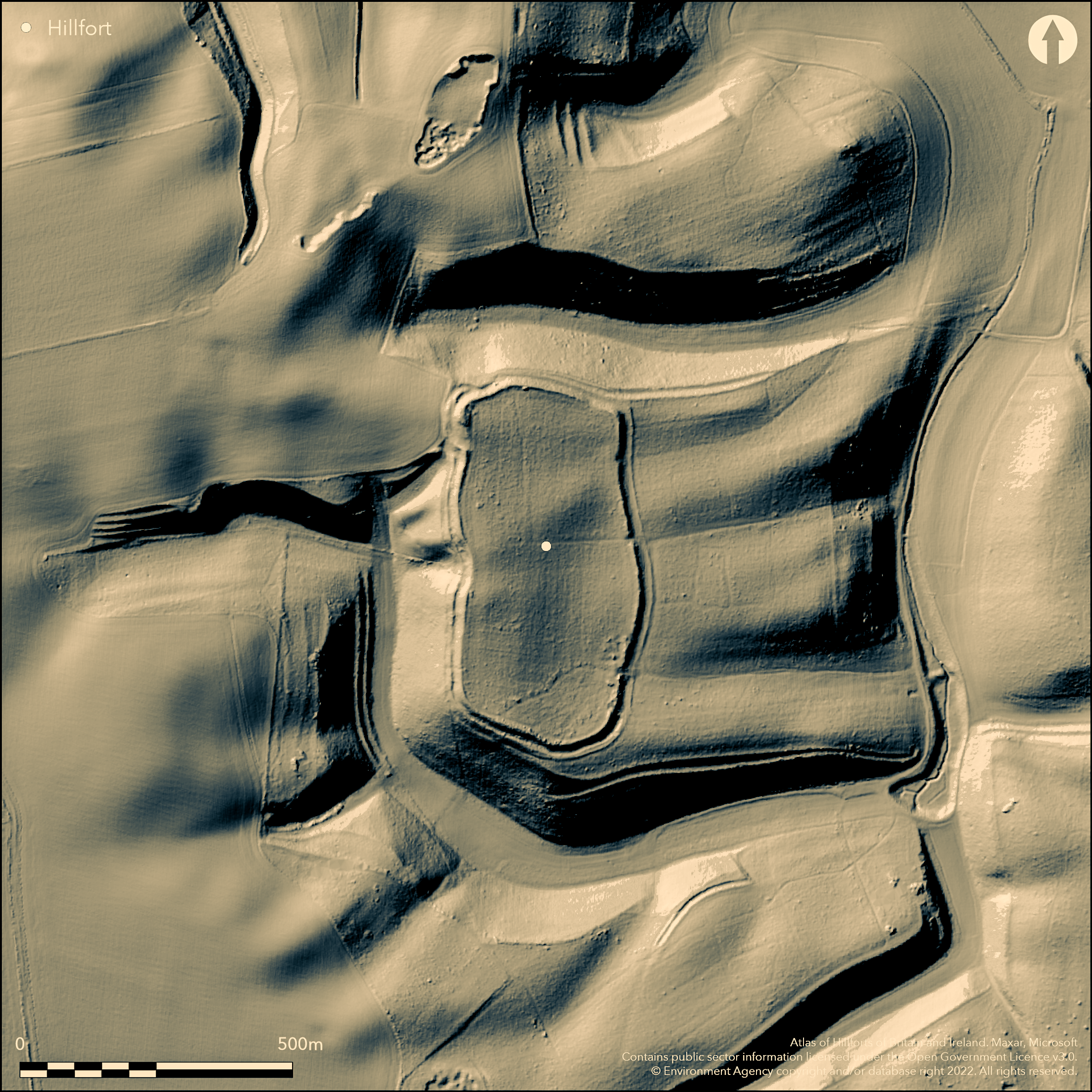
LiDAR 1m DTM Hillshade
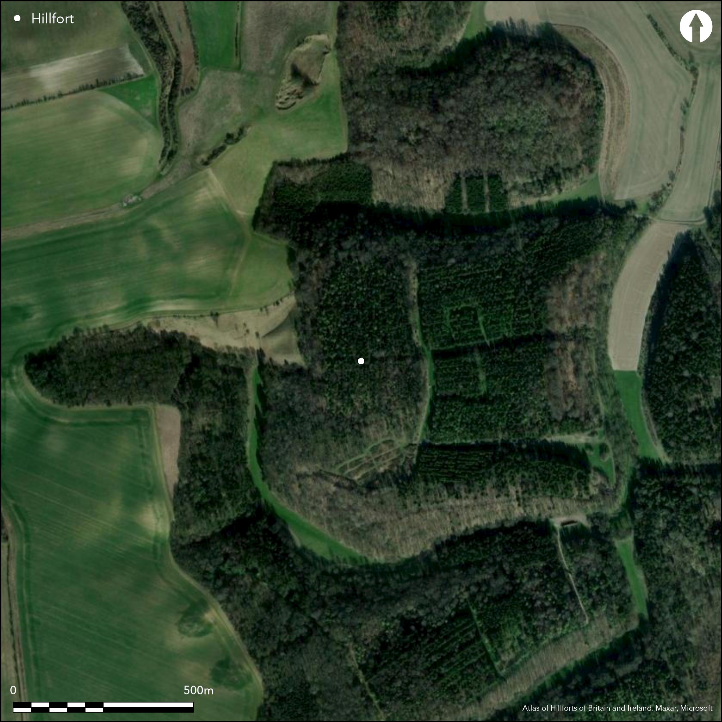
Satellite Imagery
LiDAR 1m DTM Hillshade
Satellite Imagery
Scroll left/right to view further images.
HER: Hertfordshire MHT31 (None)
NMR: TL 02 NE 7 (359533)
SM: 1003541
NGR: TL 0995 2950
X: 509940 Y: 229530 (OSGB36)
Positioned SE of Barton-in-the-Clay, a partial contour hillfort situated on the Upper Cretaceous Chalk sequence on the W half of the prominent hill top plateau of Cank Hill in the NE Chiltern Hills. Surrounded by steep dry valleys to N, S and W, less so to E, mostly within dense woodland, initially planted c. 1908, but c. 0.6ha cleared of vegetation in SE corner 2015. On 1st Ed OS map (1885-1900), first plan by Clutterbuck (1817), described by Francis Taverner 1640 and visited by William Stukeley with drawing of site 1724. Roughly oval in shape with internal area c. 6.6ha, making the site the largest in the Chilterns and E England. Topographical surveys being undertaken by I. Brown and I.P. Brooks 2013-ongoing. W ramparts, although overgrown form a coherent line. Substantial inner rampart, although internally now little more than intermittent scarp, deep internally to discontinuous medial ditch and smaller second bank , with again possible discontinuous outer ditch, or shelf, with, in places, possible counterscarp bank above the steep slopes falling to the Claypit Hole below. All increase in height and width towards the elaborate NW entrance, where, at the NW apex, possible evidence of three banks. Initial investigation of N side, finds two initial banks and ditch to be determined with possible linear dyke meeting the fort on the NE apex. To E, where slopes only moderate, high inner bank to 5m appears faced by infilled ditch with slight traces of second bank. To SW again two banks with medial and outer ditches, but possibility of further banks downslope indicate a complex arrangement, possibly confused by what appears another linear dyke running away from fort to SE. Substantial original entrances on SE and NW, with seemingly blocked entrance near NW apex. SE has damaged gap c. 6m wide with hint of inturn, and located just above Burwell Spring below fort. but NW main gate, although damaged, very elaborate, with marked out-turn to S bank and inturn N, possible outworks and complex series of banks and possible Bronze Age barrow incorporated in rampart to N. Gap used for present access just N of SE apex, showing substantial inturn, may be original. Possible postern gate on SW. Geophysical survey 2015 in SE corner of interior found evidence of several large roundhouses, linear features and possible small enclosure with inturned entrance and interior roundhouse. Excavations by John Moss-Eccardt and James Dyer 1964 and James Dyer 1970 and 1972-5 (Dyer 1976) suggest the following sequence based on pottery and stratigraphy: pre-hillfort cultivation; Period 1 rampart 4th to 3rd century BC, also La Tene 1b bow brooch c. 350 BC ; Period 2 disuse; Period 3 rebuilding, possibly 1st century BC (Belgic?). Period 1 rampart of box construction with some vertical posts replaced at least twice, possible horizontal tie beams, a footing trench for outer facing timbers, chalk and turf packing within the box. Ditch was flat-bottomed, 3m deep, 6.7m wide at the top and 2m at the bottom. In places berm separated the rampart and ditch. Period 3 saw the recutting of ditch, V-shaped 6.1m wide and 2.4m deep and piling up of chalk rubble over decaying Period 1 rampart to form dump rampart. Interior excavation (1964), 0.1ha inside SE entrance showed irregular rows of large postholes, 44 in total. Much mid to late Iron Age pottery, La Tene 1b bronze brooch and weaving comb (chance find 1990) and quantity of animal bone (sheep, pig appear to dominate). Neolithic axe. Small number of Roman coins and pottery suggest post hillfort activity. It is possible that the site may have had a pastoral downland emphasis. Site now subject to management agreement and planned survey.
Citizen Science: ✗
Reliability of Data: Confirmed
Reliability of Interpretation: Confirmed
X: -44707 Y: 6791697 (EPSG: 3857)
Longitude: -0.401605618040639 Latitude: 51.95335917190559 (EPSG:4326)
Country: England; None
Current County or Unitary Authority: Hertfordshire
Historic County: Bedfordshire
Current Parish/Community/Council/Townland: Hexton
Some quarry damage.
| Extant | ✓ |
| Cropmark | ✗ |
| Likely Destroyed | ✗ |
None
| Woodland | ✓ |
| Commercial Forestry Plantation | ✗ |
| Parkland | ✗ |
| Pasture (Grazing) | ✗ |
| Arable | ✗ |
| Scrub/Bracken | ✗ |
| Bare Outcrop | ✗ |
| Heather/Moorland | ✗ |
| Heath | ✗ |
| Built-up | ✗ |
| Coastal Grassland | ✗ |
| Other | ✗ |
A partial contour hillfort on the top of a prominent hill with steep slopes to N, S and W, less so to E,
| Contour Fort | ✗ |
| Partial Contour Fort | ✓ |
| Promontory Fort | ✗ |
| Hillslope Fort | ✗ |
| Level Terrain Fort | ✗ |
| Marsh Fort | ✗ |
| Multiple Enclosure Fort | ✗ |
| Hilltop | ✓ |
| Coastal Promontory | ✗ |
| Inland Promontory | ✗ |
| Valley Bottom | ✗ |
| Knoll/Hillock/Outcrop | ✗ |
| Ridge | ✗ |
| Cliff/Plateau-edge/Scarp | ✗ |
| Hillslope | ✗ |
| Lowland | ✗ |
| Spur | ✗ |
Dominant Topographic Feature: Prominent hilltop
| North | ✗ |
| Northeast | ✗ |
| East | ✗ |
| Southeast | ✗ |
| South | ✗ |
| Southwest | ✗ |
| West | ✗ |
| Northwest | ✗ |
| Level | ✓ |
Altitude: 137.0m
County boundary with Bedfordshire runs along the outside the W rampart
Boundary Type: County
Based on excavation (dating by pottery): pre-hillfort cultivation; Period 1 rampart 4th-3rd century BC, also a La Tene 1b brooch c. 350 BC ; Period 2 disuse; Period 3 rebuilding may be 1st century BC (Belgic?). Chance finds of slingstones. Small number of Roman coins and pottery found. Reconstructed bowl.
Reliability: B - Medium
| Pre 1200BC | ✗ |
| 1200BC - 800BC | ✗ |
| 800BC - 400BC | ✗ |
| 400BC - AD50 | ✓ |
| AD50 - AD400 | ✗ |
| AD400 - AD 800 | ✗ |
| Post AD800 | ✗ |
| Unknown | ✗ |
| Pre Hillfort: | None |
| Post Hillfort: | None |
| Artefactual: | None |
| Morphology/Earthwork/Typology: | None |
Described by Francis Taverner in 1640, first drawn plan by Clutterbuck (1817). Visit by William Stukeley 1724. On 1st Ed OS map (1885-1900). Some digging 1940's. Excavations John Moss-Eccardt 1964, James Dyer 1970 and 1972-75. Topographical and geophysical surveys and re-examination of 1964-1975 excavations by Ian Brown, University of Oxford and Ian Brooks, Engineering Archaeological Services 2013-ongoing.
| 1st Identified Written Reference (1640): | Francis Taverner. |
| Other (1724): | Visit with drawing of site by William Stukeley. |
| Excavation (1964): | John Moss-Eccardt and James Dyer. |
| Other (1974): | Visit by Hillfort Study Group |
| 1st Identified Map Depiction (None): | OS map. |
| Excavation (None): | Small digging NW entrance. |
| Excavation (None): | James Dyer. |
| Other (None): | Topographical and geophysical surveys and re-examination of 1964-1975 excavations by Ian Brown, University of Oxford and Ian Brooks, Engineering Archaeological Services. |
Interior excavation (1964), 0.1ha inside SE entrance showed irregular rows of large postholes, 44 in total, suggesting stockades/animal encloures. Much mid to late Iron Age pottery, La Tene 1b bronze brooch and weaving comb (chance find 1990) and quantity of animal bone (sheep, pig appear to dominate). Neolithic axe. Small number of Roman coins and pottery. Some grain. Geophysical survey 2015 in SE corner of interior found evidence of several large roundhouses, linear features and possible small enclosure with inturned entrance and interior roundhouse. Possible faint quarry hollows.
The Burwell spring is 35m E of the hillfort
| None | ✓ |
| Spring | ✗ |
| Stream | ✗ |
| Pool | ✗ |
| Flush | ✗ |
| Well | ✗ |
| Other | ✗ |
Possible faint quarry hollows (infilled).
| No Known Features | ✗ |
| Round Stone Structures | ✗ |
| Rectangular Stone Structures | ✗ |
| Curvilinear Platforms | ✗ |
| Other Roundhouse Evidence | ✗ |
| Pits | ✗ |
| Quarry Hollows | ✓ |
| Other | ✗ |
Interior excavation (1964), 0.1ha inside SE entrance showed irregular rows of large postholes, 44 in total, suggesting construction of stockades/animal enclosures.
| No Known Excavation | ✗ |
| Pits | ✗ |
| Postholes | ✓ |
| Roundhouses | ✗ |
| Rectangular Structures | ✗ |
| Roads/Tracks | ✗ |
| Quarry Hollows | ✗ |
| Other | ✗ |
| Nothing Found | ✗ |
Geophysical survey 2015 in SE corner of interior found evidence of several large roundhouses, linear features and possible small enclosure with inturned entrance and interior roundhouse.
| No Known Geophysics | ✗ |
| Pits | ✗ |
| Roundhouses | ✓ |
| Rectangular Structures | ✗ |
| Roads/Tracks | ✗ |
| Quarry Hollows | ✗ |
| Other | ✓ |
| Nothing Found | ✗ |
Much mid to late Iron Age pottery, La Tene 1b bronze brooch and weaving comb (chance find 1990) and quantity of animal bone (sheep, pig appear to dominate). Neolithic axe. Small number of Roman coins and pottery. Some grain.
| No Known Finds | ✗ |
| Pottery | ✓ |
| Metal | ✓ |
| Metalworking | ✗ |
| Human Bones | ✗ |
| Animal Bones | ✓ |
| Lithics | ✓ |
| Environmental | ✓ |
| Other | ✗ |
None
| APs Not Checked | ✓ |
| None | ✗ |
| Roundhouses | ✗ |
| Rectangular Structures | ✗ |
| Pits | ✗ |
| Postholes | ✗ |
| Roads/Tracks | ✗ |
| Other | ✗ |
Substantial original entrances on SE and NW. SE (possibly damaged) has gap with hint of inturn, but NW main gate, although damaged, very elaborate, with marked out-turn to S bank and inturn N, possible outworks and complex series of banks, and possible Bronze Age barrow incorporated in rampart overlooking passageway to N. Gap just N of SE apex, used for present access to site, shows marked inturn and could be possible entrance - being invetigated 2016. Possible postern gate on SW found 2016.
| 6: | Gap just N of SE apex used for present access to site, shows marked inturn and requires further investigation. |
| 2: | None |
Guard Chambers: ✗
Chevaux de Frise: ✗
| 1. Out-turned (North west): | Out-turn to S bank and inturn to N. |
| 1. Blocked (North west): | Possible blocked entrance near NW apex |
| 1. Outworks (North west): | None |
| 1. In-turned (North west): | Out-turn to S bank and inturn to N. |
| 2. Simple Gap (South east): | Possible hint of inturn, but appears damaged. |
| 2. In-turned (South east): | Possible hint of inturn, but appears damaged. |
| 3. Postern Gate (South west): | Possible postern gate found 2016. |
| 4. In-turned (South east): | Gap just N of SE apex, used for present access to site, shows marked inturn and could be possible entrance. |
W ramparts, although overgrown form a coherent line. Substantial inner rampart, although internally now little more than intermittent scarp, deep internally to discontinuous medial ditch and smaller second bank , with again possible discontinuous outer ditch, or shelf, with, in places, possible counterscarp bank above the steep slopes falling to the Claypit Hole below. All increase in height and width towards the elaborate NW entrance, where, at the NW apex, possible evidence of three banks. Initial investigation of N side, finds two initial banks and ditch to be determined with possible linear dyke meeting the fort on the NE apex. To E, where slopes only moderate, high inner bank to 5m appears faced by infilled ditch with slight traces of second bank. To SW again two banks with medial and outer ditches, but possibility of further banks downslope indicate a complex arrangement, possibly confused by what appears another linear dyke running away from fort to SE. Excavations (Dyer 1976) suggest the following sequence: Period 1 rampart 4th-3rd century BC, of box construction with some of the vertical posts being replaced at least twice, possible horizontal tie beams, a footing trench for outer facing timbers, chalk and turf packing within the box. The ditch was flat-bottomed, 3m deep, 6.7m wide at the top and 2m at the bottom. In places a berm separated the rampart and ditch. Period 3 rebuilding may be 1st century BC (Belgic?) and saw the recutting of the ditch, V-shaped 6.1m wide and 2.4m deep and the piling up of chalk rubble over the decaying Period 1 rampart to form a dump rampart.
| Area 1: | 6.5ha. |
| Total: | 6.5ha. |
Total Footprint Area: Noneha.
None
| ✓ | Phased construction suggested by Dyer (1976). |
| ✓ | It is possible that there could be c. three or four banks on SW, but unclear at present as possible linear dyke abuts fort to be determined. |
| NE Quadrant: | 2 |
| SE Quadrant: | 2 |
| SW Quadrant: | 2 |
| NW Quadrant: | 3 |
| Total: | 3 |
| Partial Univallate | ✗ |
| Univallate | ✗ |
| Partial Bivallate | ✓ |
| Bivallate | ✗ |
| Partial Multivallate | ✓ |
| Multivallate | ✗ |
| Unknown | ✗ |
| Partial Univallate | ✗ |
| Univallate | ✗ |
| Partial Bivallate | ✗ |
| Bivallate | ✗ |
| Partial Multivallate | ✗ |
| Multivallate | ✗ |
Possible berms evident and counterscarp traces. Bank of chalk rubble.
| None | ✗ |
| Earthen Bank | ✓ |
| Stone Wall | ✗ |
| Rubble | ✓ |
| Wall-walk | ✗ |
| Evidence of Timber | ✗ |
| Vitrification | ✗ |
| Other Burning | ✗ |
| Palisade | ✗ |
| Counter Scarp Bank | ✓ |
| Berm | ✓ |
| Unfinished | ✗ |
| Other | ✗ |
Excavations (Dyer 1976) suggest the following sequence: Period 1 rampart 4th-3rd century BC, of box construction with some of the vertical posts being replaced at least twice, possible horizontal tie beams, a footing trench for outer facing timbers, chalk and turf packing within the box. The ditch was flat-bottomed, 3m deep, 6.7m wide at the top and 2m at the bottom. In places a berm separated the rampart and ditch. Period 3 rebuilding may be 1st century BC (Belgic?) and saw the recutting of the ditch, V-shaped 6.1m wide and 2.4m deep and the piling up of chalk rubble over the decaying Period 1 rampart to form a dump rampart.
| None | ✗ |
| Earthen Bank | ✗ |
| Stone Wall | ✗ |
| Murus Duplex | ✗ |
| Timber-framed | ✓ |
| Timber-laced | ✓ |
| Vitrification | ✗ |
| Other Burning | ✗ |
| Palisade | ✗ |
| Counter Scarp Bank | ✓ |
| Berm | ✓ |
| Unfinished | ✗ |
| No Known Excavation | ✗ |
| Other | ✗ |
| ✗ | None |
| ✓ | At least two. |
Number of Ditches: 2
| ✗ | None |
Brooks, I.P. 2015. Ravensburgh Hillfort geophysical survey, EAS Client Report 2015/10, Engineering Archaeological Services.
Brown, I. 2015. Project outline and topographical and geophysical surveys of Ravensburgh Castle Hillfort, Hexton, Hertfordshire, Ravensburgh Castle Hillfort Project Interim Report No 1, Unpublished report University of Oxford.
Clutterbuck, T. 1817. The history of Hertfordshire. Volume 3.
Dyer, J. 1976. Ravensburgh Castle, Hertfordshire. In Harding, D. (ed) Hillforts. Later prehistoric earthworks in Britain and Ireland. London: Academic Press, 153-159.
Atlas of Hillforts:
Wikidata:
This work is licensed under CC BY-SA 4.0

 and should be cited as:
Lock, Gary and Ralston, Ian. 2024. Atlas of Hillforts of Britain and Ireland. Available at: https://hillforts.arch.ox.ac.uk
Document Version 1.1