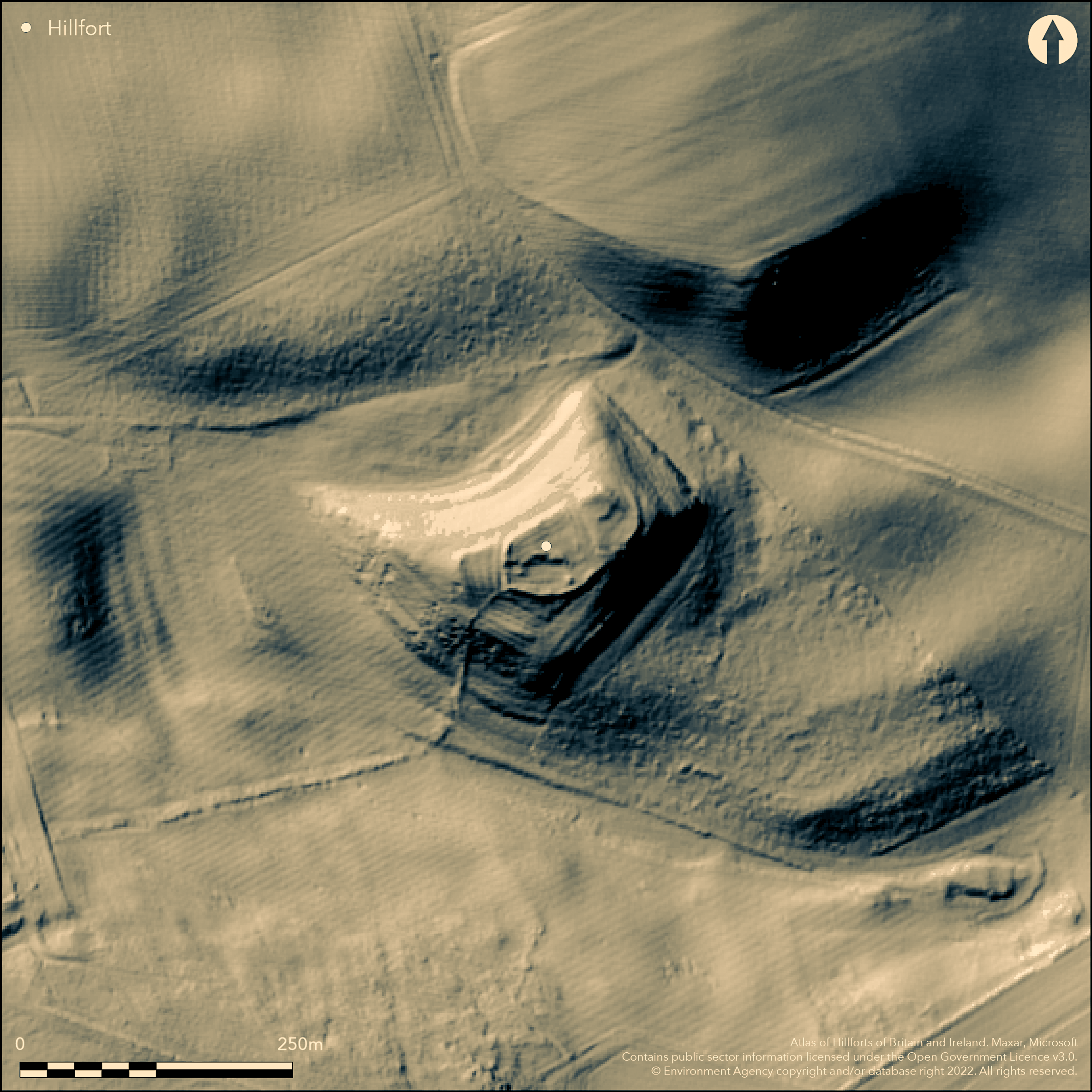
LiDAR 1m DTM Hillshade
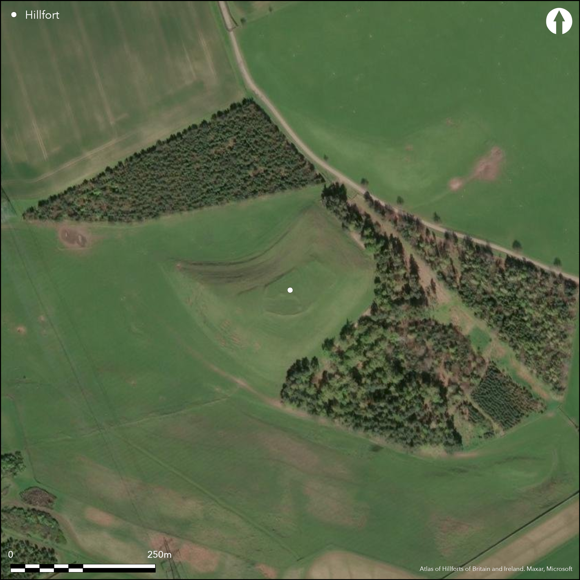
Satellite Imagery
LiDAR 1m DTM Hillshade
Satellite Imagery
Scroll left/right to view further images.
HER: Northumberland 3487 (None)
NMR: NU 02 SW 11 (5880)
SM: 1018067
NGR: NU 00485 23071
X: 400485 Y: 623071 (OSGB36)
An enclosure lying 740m to the SE of South Middleton, included in Hogg (1979) as a univallate hillfort of 0.2ha. Lies in a dominant position at 157m OD at the E end of Foxes Knoll with the ground dropping away sharply in E and N and commanding extensive views in these directions. Irregular in form with an annex in the W, its overall measurement is 103m W-S-W by 51m N-S enclosing 0.2ha within a single earth and stone rampart with a stone facing. The rampart stands at 3m wide and 0.5m high and where enhanced by the natural hillslope 1-2m high. No evidence of ditches. An in-turned entrance lies in the N. An annex measures approximately 29m N-S by 23m E-W and is defined by a bank 0.3m high. Internally the enclosure is divided into two areas by a bank, in the E there is a sub-circular platform 8m in diameter, a scooped area 9m in diameter enclosed by a slight bank and a possible hut circle. In the W a sub-rectangular enclosure with an internal dividing bank and a yard have been recorded. The internal compounds possibly relate to secondary, Romano-British occupation. A field bank, 1m wide and 0.5m high constructed of facing stones with a rubble core is possibly contemporary with the settlement. It runs from the south side of the enclosure down the hillside and diagonally up the opposite hillside. The walls are tumbled and spread. The site is shown on 1856-65 OS mapping. Minimal investigations and undated. Scheduled as a defended settlement.
Citizen Science: ✗
Reliability of Data: Confirmed
Reliability of Interpretation: Confirmed
X: -221957 Y: 7459802 (EPSG: 3857)
Longitude: -1.9938704922050525 Latitude: 55.50145277582193 (EPSG:4326)
Country: England
Current County or Unitary Authority: Northumberland
Historic County: Northumberland
Current Parish/Community/Council/Townland: Ilderton
None
| Extant | ✓ |
| Cropmark | ✗ |
| Likely Destroyed | ✗ |
None
| Woodland | ✗ |
| Commercial Forestry Plantation | ✗ |
| Parkland | ✗ |
| Pasture (Grazing) | ✓ |
| Arable | ✗ |
| Scrub/Bracken | ✗ |
| Bare Outcrop | ✗ |
| Heather/Moorland | ✗ |
| Heath | ✗ |
| Built-up | ✗ |
| Coastal Grassland | ✗ |
| Other | ✗ |
A univallate contour fort of 0.2ha lying on level ground at 157m OD at the eastern end of a prominent knoll
| Contour Fort | ✓ |
| Partial Contour Fort | ✗ |
| Promontory Fort | ✗ |
| Hillslope Fort | ✗ |
| Level Terrain Fort | ✗ |
| Marsh Fort | ✗ |
| Multiple Enclosure Fort | ✗ |
| Hilltop | ✗ |
| Coastal Promontory | ✗ |
| Inland Promontory | ✗ |
| Valley Bottom | ✗ |
| Knoll/Hillock/Outcrop | ✓ |
| Ridge | ✗ |
| Cliff/Plateau-edge/Scarp | ✗ |
| Hillslope | ✗ |
| Lowland | ✗ |
| Spur | ✗ |
Dominant Topographic Feature: Prominent knoll
| North | ✗ |
| Northeast | ✗ |
| East | ✗ |
| Southeast | ✗ |
| South | ✗ |
| Southwest | ✗ |
| West | ✗ |
| Northwest | ✗ |
| Level | ✓ |
Altitude: 157.0m
N/A
Undated, presumed Iron Age. Possible Romano-British settlement
Reliability: D - None
| Pre 1200BC | ✗ |
| 1200BC - 800BC | ✗ |
| 800BC - 400BC | ✗ |
| 400BC - AD50 | ✗ |
| AD50 - AD400 | ✗ |
| AD400 - AD 800 | ✗ |
| Post AD800 | ✗ |
| Unknown | ✓ |
| Pre Hillfort: | None |
| Post Hillfort: | Possible Romano-British settlement |
| Morphology/Earthwork/Typology: | None |
Recorded by the OS on 1856-65 mapping, general reference in MacLauchlan (1867). Field investigations in 1955, 1969 and 1974. First scheduled in 1966.
| 1st Identified Written Reference (1867): | None |
| Other (1955): | Field investigation |
| Other (1966): | Scheduled |
| Other (1969): | Field investigation |
| Other (1974): | Field investigation |
| 1st Identified Map Depiction (None): | None |
Internally the enclosure is divided into two areas by a bank; in the E there is a sub-circular platform 8m in diameter, a scooped area 9m in diameter enclosed by a slight bank, and a possible hut circle. In the W a sub-rectangular enclosure with an internal dividing bank and a yard have been recorded.
Lilburn Burn to the E
| None | ✓ |
| Spring | ✗ |
| Stream | ✗ |
| Pool | ✗ |
| Flush | ✗ |
| Well | ✗ |
| Other | ✗ |
Sub-circular platform 8m in diameter, a scooped area 9m in diameter enclosed by a slight bank and a possible hut circle. In the W a sub-rectangular enclosure with an internal dividing bank and a yard. The internal compounds possibly relate to secondary, Romano-British occupation
| No Known Features | ✗ |
| Round Stone Structures | ✓ |
| Rectangular Stone Structures | ✓ |
| Curvilinear Platforms | ✗ |
| Other Roundhouse Evidence | ✗ |
| Pits | ✗ |
| Quarry Hollows | ✗ |
| Other | ✓ |
None
| No Known Excavation | ✓ |
| Pits | ✗ |
| Postholes | ✗ |
| Roundhouses | ✗ |
| Rectangular Structures | ✗ |
| Roads/Tracks | ✗ |
| Quarry Hollows | ✗ |
| Other | ✗ |
| Nothing Found | ✗ |
None
| No Known Geophysics | ✓ |
| Pits | ✗ |
| Roundhouses | ✗ |
| Rectangular Structures | ✗ |
| Roads/Tracks | ✗ |
| Quarry Hollows | ✗ |
| Other | ✗ |
| Nothing Found | ✗ |
None
| No Known Finds | ✓ |
| Pottery | ✗ |
| Metal | ✗ |
| Metalworking | ✗ |
| Human Bones | ✗ |
| Animal Bones | ✗ |
| Lithics | ✗ |
| Environmental | ✗ |
| Other | ✗ |
None
| APs Not Checked | ✓ |
| None | ✗ |
| Roundhouses | ✗ |
| Rectangular Structures | ✗ |
| Pits | ✗ |
| Postholes | ✗ |
| Roads/Tracks | ✗ |
| Other | ✗ |
A single in-turned entrance lies in the N
| 1: | None |
| 2: | None |
Guard Chambers: ✗
Chevaux de Frise: ✗
| 1. In-turned (North): | None |
Irregular in form with an annex in the W, its overall measurement is 103m W-S-W by 51m N-S. It is enclosed by a single earth and stone rampart with a stone facing. The rampart stands at 3m wide and 0.5m high and where enhanced by the natural hillslope 1-2m high. No evidence of ditches.
| Area 1: | 0.2ha. |
| Total: | 0.2ha. |
Total Footprint Area: 0.38ha.
None
| ✗ | Whole site footprint approximate, measured from satellite imagery |
| ✓ | None |
| NE Quadrant: | 1 |
| SE Quadrant: | 1 |
| SW Quadrant: | 1 |
| NW Quadrant: | 1 |
| Total: | 1 |
| Partial Univallate | ✗ |
| Univallate | ✓ |
| Partial Bivallate | ✗ |
| Bivallate | ✗ |
| Partial Multivallate | ✗ |
| Multivallate | ✗ |
| Unknown | ✗ |
| Partial Univallate | ✗ |
| Univallate | ✗ |
| Partial Bivallate | ✗ |
| Bivallate | ✗ |
| Partial Multivallate | ✗ |
| Multivallate | ✗ |
None
| None | ✗ |
| Earthen Bank | ✓ |
| Stone Wall | ✓ |
| Rubble | ✓ |
| Wall-walk | ✗ |
| Evidence of Timber | ✗ |
| Vitrification | ✗ |
| Other Burning | ✗ |
| Palisade | ✗ |
| Counter Scarp Bank | ✗ |
| Berm | ✗ |
| Unfinished | ✗ |
| Other | ✗ |
None
| None | ✗ |
| Earthen Bank | ✗ |
| Stone Wall | ✗ |
| Murus Duplex | ✗ |
| Timber-framed | ✗ |
| Timber-laced | ✗ |
| Vitrification | ✗ |
| Other Burning | ✗ |
| Palisade | ✗ |
| Counter Scarp Bank | ✗ |
| Berm | ✗ |
| Unfinished | ✗ |
| No Known Excavation | ✓ |
| Other | ✗ |
| ✗ | None |
| ✗ | None recorded |
Number of Ditches: None
| ✓ | The annex lies to the W of the main enclosure and is defined by a bank 0.3m high. It measures approximately 29m N-S by 23m E-W |
Hogg, A.H.A. 1979. British Hill-Forts. An Index. British Archaeological Reports, British Series 62, 124
Jobey, G. 1965. Hillforts and Settlements in Northumberland. Archaeol Aeliana (4th Series) 43
MacLauchlan, H. 1867. Notes not included in the memoirs already published on Roman roads in Northumberland (London), 43 and note.
Atlas of Hillforts:
Wikidata:
This work is licensed under CC BY-SA 4.0![]()
![]()
![]() and should be cited as:
and should be cited as:
Lock, Gary and Ralston, Ian. 2024. Atlas of Hillforts of Britain and Ireland. Available at: https://hillforts.arch.ox.ac.uk
Document Version 1.1