LiDAR 1m DTM Hillshade
Satellite Imagery
LiDAR 1m DTM Hillshade
Satellite Imagery
Scroll left/right to view further images.
HER: Northumberland 3786 (None)
NMR: NU 03 SW 9 (6221)
SM: 1006587
NGR: NU 01387 31832
X: 401387 Y: 631832 (OSGB36)
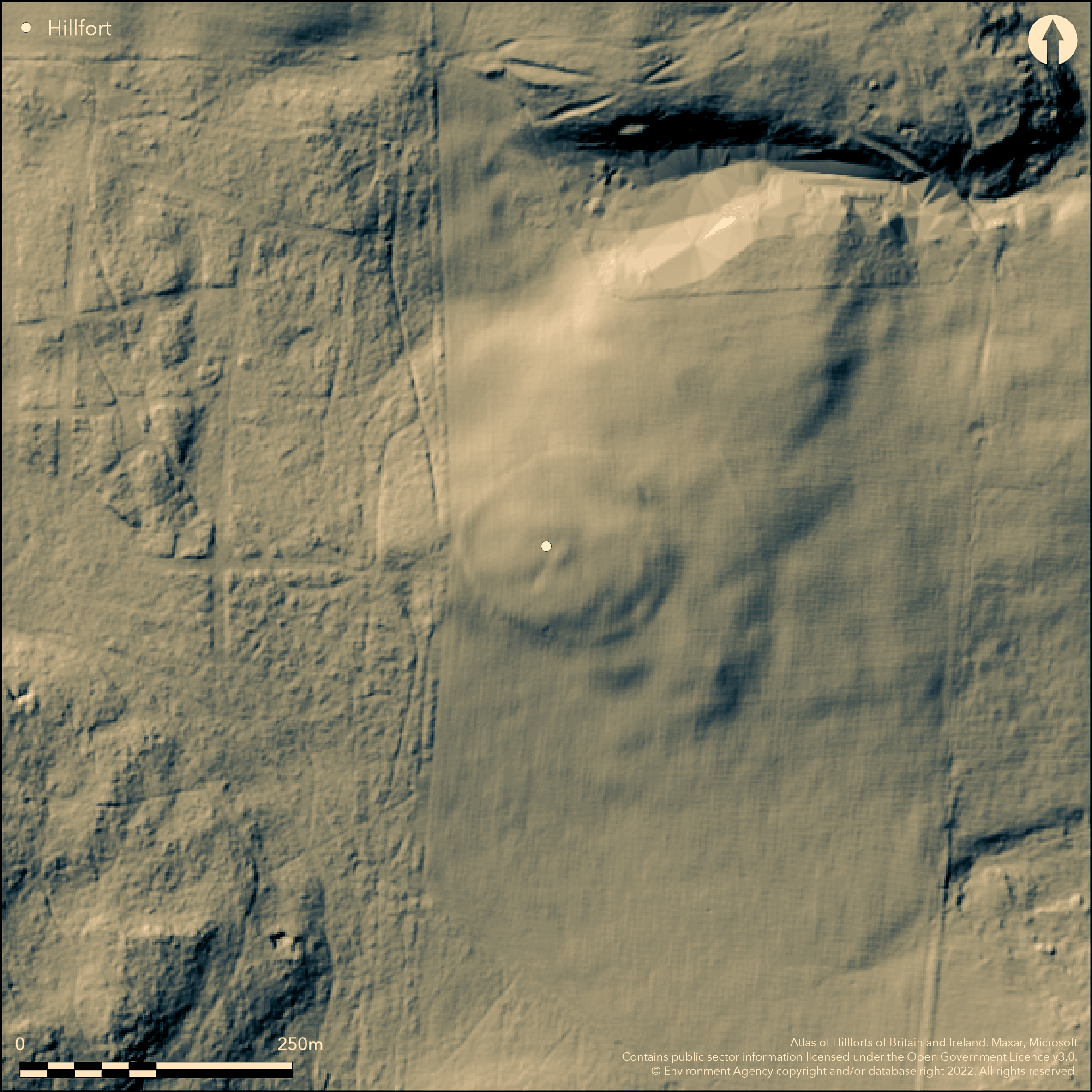
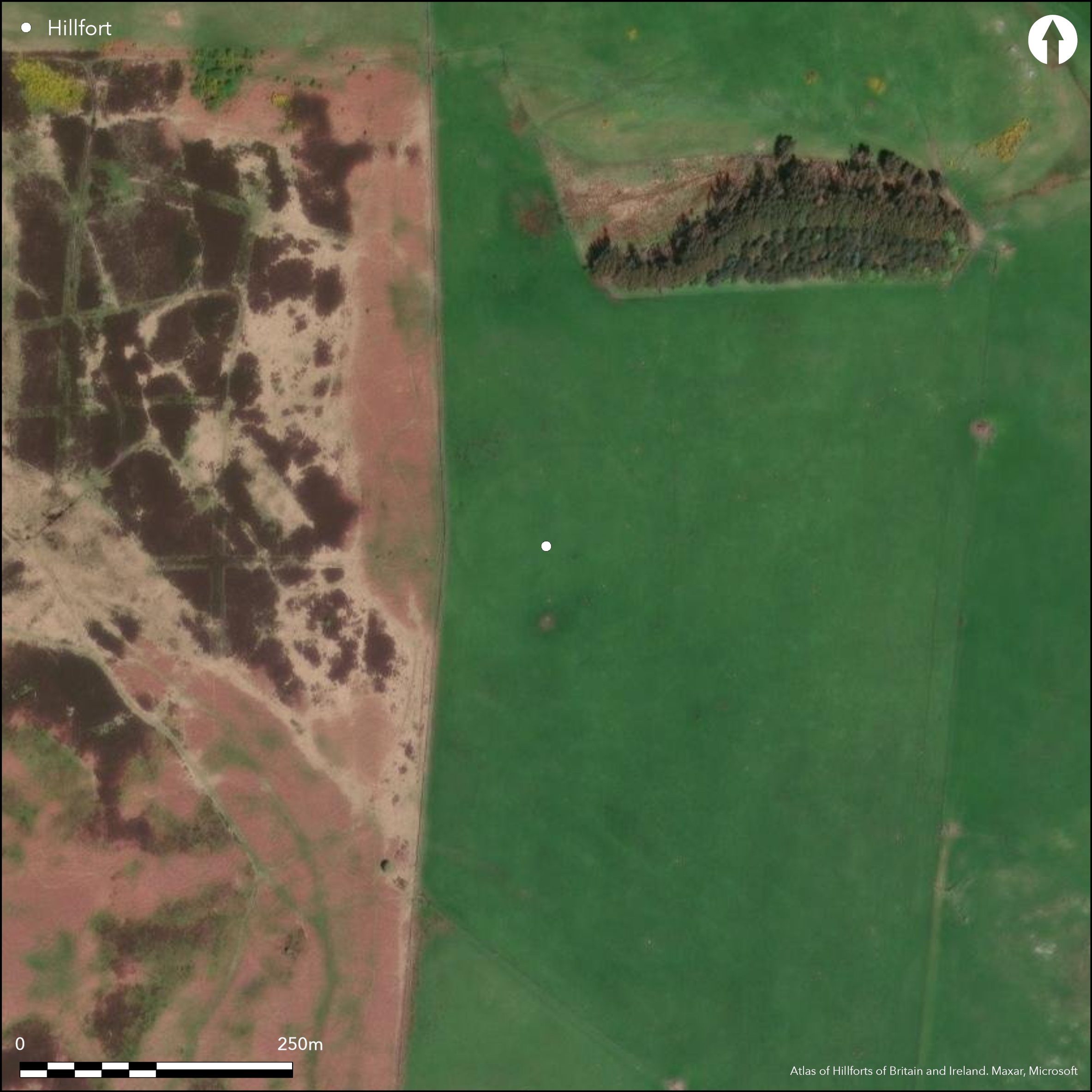
Lying to the N of Doddington Moor Standing Stones, an enclosure, probably a hillfort listed by Hogg (1979, 125) as Horton Moor. Now ploughed out. It lies on the summit of a slight rise at 160m OD. Circular in plan enclosing 0.6ha, it comprised a single earth and stone rampart and an outer ditch. An OS field investigation in 1955 recorded the rampart as 4m wide and 0.7m high internally and 2m above the bottom of the ditch. The width of the ditch averaged 6m with a maximum depth of 0.7m. Faint traces of a counterscarp were also recorded. Several gaps in the ramparts were observed but no entrance could be determined. No internal features were recorded but bracken prevented close inspection. A mound 12m by 9m and 0.4m high within the enclosure was said to be a burial mound but this was never verified. A cup marked stone was recorded in the interior. The site is shown on 1856-65 OS mapping but no investigation is known. It can be seen as a cropmark on 2006 Google earth imagery, though the ditch is no more than 3m wide, enclosing an area measuring 110m from E to W by 100m transversely. Undated, scheduled.
Citizen Science: ✗
Reliability of Data: Confirmed
Reliability of Interpretation: Unconfirmed
X: -220363 Y: 7475290 (EPSG: 3857)
Longitude: -1.9795504868884652 Latitude: 55.58017353702593 (EPSG:4326)
Country: England; None
Current County or Unitary Authority: Northumberland
Historic County: Northumberland
Current Parish/Community/Council/Townland: Chatton; Doddington
None
| Extant | ✗ |
| Cropmark | ✓ |
| Likely Destroyed | ✗ |
None
| Woodland | ✗ |
| Commercial Forestry Plantation | ✗ |
| Parkland | ✗ |
| Pasture (Grazing) | ✓ |
| Arable | ✗ |
| Scrub/Bracken | ✓ |
| Bare Outcrop | ✗ |
| Heather/Moorland | ✗ |
| Heath | ✗ |
| Built-up | ✗ |
| Coastal Grassland | ✗ |
| Other | ✗ |
A former contour fort lying on level ground on the summit of a slight rise at 160m OD
| Contour Fort | ✓ |
| Partial Contour Fort | ✗ |
| Promontory Fort | ✗ |
| Hillslope Fort | ✗ |
| Level Terrain Fort | ✗ |
| Marsh Fort | ✗ |
| Multiple Enclosure Fort | ✗ |
| Hilltop | ✓ |
| Coastal Promontory | ✗ |
| Inland Promontory | ✗ |
| Valley Bottom | ✗ |
| Knoll/Hillock/Outcrop | ✗ |
| Ridge | ✗ |
| Cliff/Plateau-edge/Scarp | ✗ |
| Hillslope | ✗ |
| Lowland | ✗ |
| Spur | ✗ |
Dominant Topographic Feature: Summit of a slight rise
| North | ✗ |
| Northeast | ✗ |
| East | ✓ |
| Southeast | ✗ |
| South | ✗ |
| Southwest | ✗ |
| West | ✗ |
| Northwest | ✗ |
| Level | ✗ |
Altitude: 160.0m
Lies within Chatton on the eastern parish boundary of Doddington
Boundary Type: Parish/Townland
Undated
Reliability: D - None
| Pre 1200BC | ✗ |
| 1200BC - 800BC | ✗ |
| 800BC - 400BC | ✗ |
| 400BC - AD50 | ✗ |
| AD50 - AD400 | ✗ |
| AD400 - AD 800 | ✗ |
| Post AD800 | ✗ |
| Unknown | ✓ |
| Pre Hillfort: | None |
| Post Hillfort: | None |
Shown on 1856-65 OS mapping and recorded by McLauchlan, 1864. Field investigations in 1955, 1964 and 1968. Scheduled. Cropmarks visible on 2006 satellite imagery
| 1st Identified Written Reference (1864): | None |
| Other (1955): | Field investigation |
| Other (1964): | Field investigation |
| Other (1968): | Field investigation |
| 1st Identified Map Depiction (None): | None |
| Other (None): | Scheduled |
No features recorded
None
| None | ✓ |
| Spring | ✗ |
| Stream | ✗ |
| Pool | ✗ |
| Flush | ✗ |
| Well | ✗ |
| Other | ✗ |
Mound
| No Known Features | ✗ |
| Round Stone Structures | ✗ |
| Rectangular Stone Structures | ✗ |
| Curvilinear Platforms | ✗ |
| Other Roundhouse Evidence | ✗ |
| Pits | ✗ |
| Quarry Hollows | ✗ |
| Other | ✓ |
None
| No Known Excavation | ✓ |
| Pits | ✗ |
| Postholes | ✗ |
| Roundhouses | ✗ |
| Rectangular Structures | ✗ |
| Roads/Tracks | ✗ |
| Quarry Hollows | ✗ |
| Other | ✗ |
| Nothing Found | ✗ |
None
| No Known Geophysics | ✓ |
| Pits | ✗ |
| Roundhouses | ✗ |
| Rectangular Structures | ✗ |
| Roads/Tracks | ✗ |
| Quarry Hollows | ✗ |
| Other | ✗ |
| Nothing Found | ✗ |
None
| No Known Finds | ✓ |
| Pottery | ✗ |
| Metal | ✗ |
| Metalworking | ✗ |
| Human Bones | ✗ |
| Animal Bones | ✗ |
| Lithics | ✗ |
| Environmental | ✗ |
| Other | ✗ |
None
| APs Not Checked | ✗ |
| None | ✓ |
| Roundhouses | ✗ |
| Rectangular Structures | ✗ |
| Pits | ✗ |
| Postholes | ✗ |
| Roads/Tracks | ✗ |
| Other | ✗ |
No entrances could be identified, three breaks through the ramparts
| 3: | None |
| 2: | None |
Guard Chambers: ✗
Chevaux de Frise: ✗
Circular in plan enclosing 0.6ha. It comprised a single earth and stone rampart and an outer ditch. An RCHME field investigation in 1955 recorded the rampart as 4m wide and 0.7m high internally and 2m above the bottom of the ditch. The width of the ditch averaged 6m with a maximum depth of 0.7m. Faint traces of a counterscarp were also recorded. Cropmarks on satellite imagery from 2006, however, show a ditch no more than 3m broad.
| Area 1: | 0.6ha. |
| Total: | 0.6ha. |
Total Footprint Area: Noneha.
None
| ✗ | None |
| ✓ | None |
| NE Quadrant: | 1 |
| SE Quadrant: | 1 |
| SW Quadrant: | 1 |
| NW Quadrant: | 1 |
| Total: | 1 |
| Partial Univallate | ✗ |
| Univallate | ✓ |
| Partial Bivallate | ✗ |
| Bivallate | ✗ |
| Partial Multivallate | ✗ |
| Multivallate | ✗ |
| Unknown | ✗ |
| Partial Univallate | ✗ |
| Univallate | ✗ |
| Partial Bivallate | ✗ |
| Bivallate | ✗ |
| Partial Multivallate | ✗ |
| Multivallate | ✗ |
None
| None | ✗ |
| Earthen Bank | ✓ |
| Stone Wall | ✗ |
| Rubble | ✓ |
| Wall-walk | ✗ |
| Evidence of Timber | ✗ |
| Vitrification | ✗ |
| Other Burning | ✗ |
| Palisade | ✗ |
| Counter Scarp Bank | ✓ |
| Berm | ✗ |
| Unfinished | ✗ |
| Other | ✗ |
None
| None | ✗ |
| Earthen Bank | ✗ |
| Stone Wall | ✗ |
| Murus Duplex | ✗ |
| Timber-framed | ✗ |
| Timber-laced | ✗ |
| Vitrification | ✗ |
| Other Burning | ✗ |
| Palisade | ✗ |
| Counter Scarp Bank | ✗ |
| Berm | ✗ |
| Unfinished | ✗ |
| No Known Excavation | ✓ |
| Other | ✗ |
| ✗ | None |
| ✓ | None |
Number of Ditches: 1
| ✗ | None |
Hogg, A.H.A.1979. British Hill-Forts. An Index. British Archaeological Reports, British Series 62. 125
Jobey, G. 1965. Hillforts and Settlements in Northumberland. Archaeol Aeliana (4th Series) 43
MacLauchlan, H. 1864. Memoir written during a survey of the eastern branch of the Watling Street (London)
Atlas of Hillforts:
Wikidata:
This work is licensed under CC BY-SA 4.0![]()
![]()
![]() and should be cited as:
and should be cited as:
Lock, Gary and Ralston, Ian. 2024. Atlas of Hillforts of Britain and Ireland. Available at: https://hillforts.arch.ox.ac.uk
Document Version 1.1