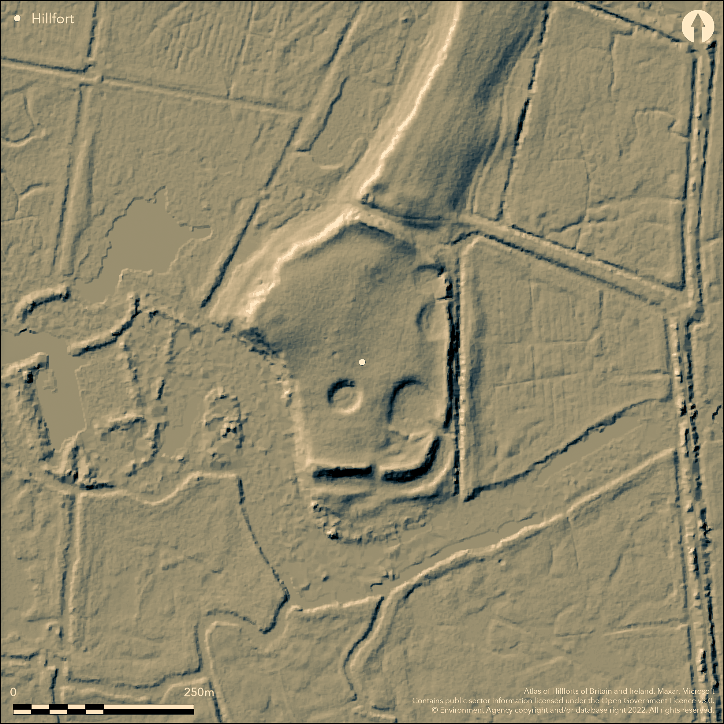
LiDAR 1m DTM Hillshade
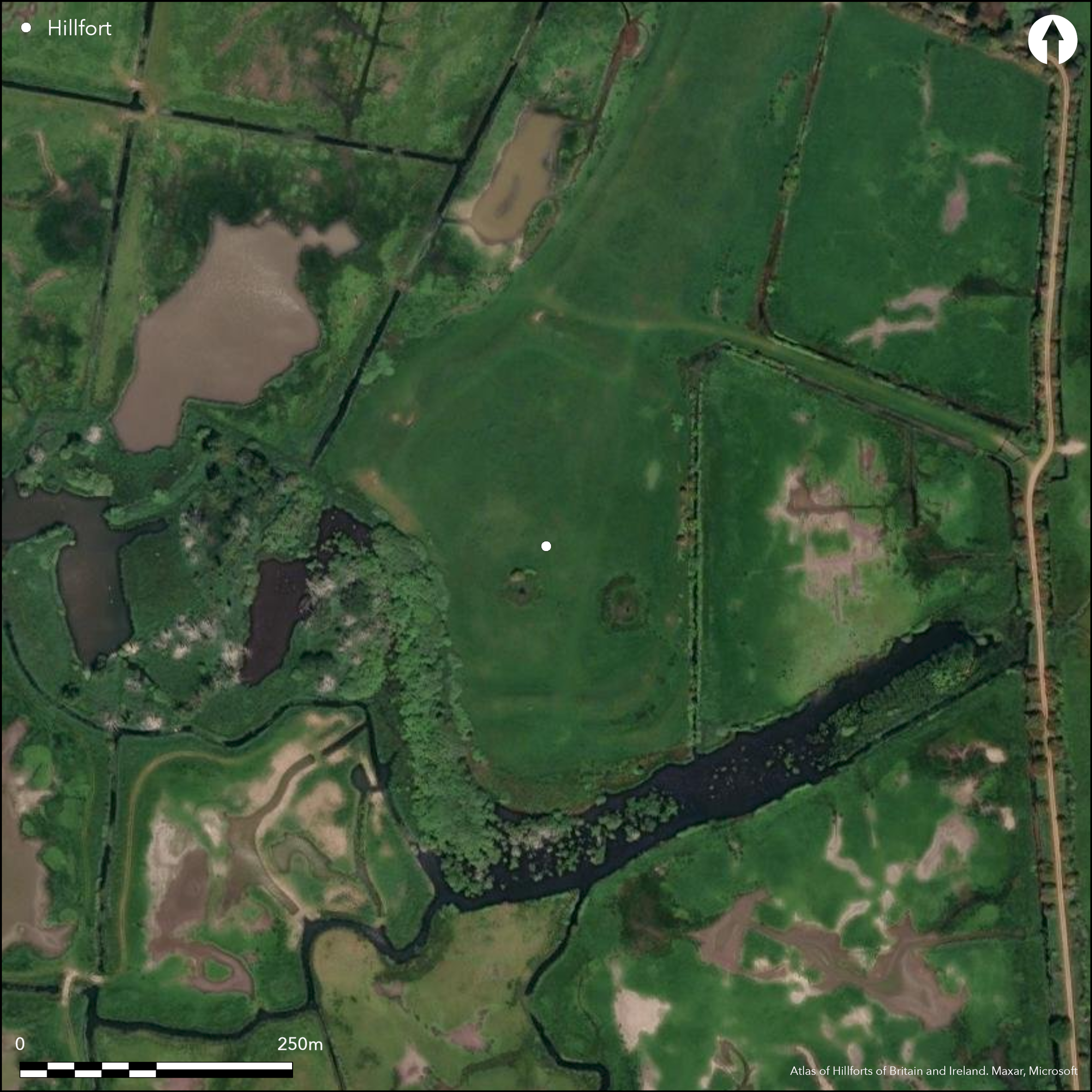
Satellite Imagery
LiDAR 1m DTM Hillshade
Satellite Imagery
Scroll left/right to view further images.
HER: Norfolk 1776 (None)
NMR: TF 8 4 SE 1 (358409)
SM: 1018014
NGR: TF 874 447
X: 587430 Y: 344730 (OSGB36)
Located NW of Holkham on the southern end of a sand and gravel plateau/spit which extends S from the coastal dunes known as Holkham Meals and surrounded on three sides by a former tidal salt marsh, now drained. First described in the 17th century, on a map of 1826, on 1st Ed OS map (1885-1900). A sub-oval enclosure approximately 375m N-Sh by 255m E-W, enclosing 2.5ha, earthwork survey in 1976 (Rickett 1991). It is bounded on the W by a steep natural scarp approximately 3m high above the level of the marsh, and on the N, E and S by an earthen bank and outer ditch. On the W and S sides, where the natural slope of the ground is more gentle, there is also an outer counterscarp bank. The inner bank stands between 1m and 2m in height and the counterscarp bank between 0.4m and 1.4m. The ditch, which has become partly infilled but remains open to a depth of up to 1m, is between 10m and 17m in width. A gap approximately 9m wide in the banks on the S side is thought to mark an original entrance, and beyond the gap, to the S and E, are slight earthworks which probably represent the remains of an outwork protecting this entrance. Three other gaps through the inner bank on the E side are associated with overflow channels from three later roughly circular, shallow ponds on the E side of the interior. Surface finds of two sherds of Iron Age pottery, flints and medieval pottery. May be the site that Tacitus describes, where the Romans under the command of Ostorius Scapula defeated a rebellious faction of the local tribe, the Iceni, in AD 47.
Citizen Science: ✓
Reliability of Data: Confirmed
Reliability of Interpretation: Confirmed
X: 87894 Y: 6976921 (EPSG: 3857)
Longitude: 0.7895643590682784 Latitude: 52.967136373126806 (EPSG:4326)
Country: England
Current County or Unitary Authority: Norfolk
Historic County: Norfolk
Current Parish/Community/Council/Townland: Holkham
None
| Extant | ✓ |
| Cropmark | ✗ |
| Likely Destroyed | ✗ |
None
| Woodland | ✗ |
| Commercial Forestry Plantation | ✗ |
| Parkland | ✗ |
| Pasture (Grazing) | ✓ |
| Arable | ✗ |
| Scrub/Bracken | ✗ |
| Bare Outcrop | ✗ |
| Heather/Moorland | ✗ |
| Heath | ✗ |
| Built-up | ✗ |
| Coastal Grassland | ✓ |
| Other | ✗ |
On the southern end of a sand and gravel plateau/spit which extends S from the coastal dunes, surrounded on three sides by coastal marsh
| Contour Fort | ✗ |
| Partial Contour Fort | ✗ |
| Promontory Fort | ✗ |
| Hillslope Fort | ✗ |
| Level Terrain Fort | ✗ |
| Marsh Fort | ✓ |
| Multiple Enclosure Fort | ✗ |
| Hilltop | ✗ |
| Coastal Promontory | ✗ |
| Inland Promontory | ✗ |
| Valley Bottom | ✗ |
| Knoll/Hillock/Outcrop | ✗ |
| Ridge | ✗ |
| Cliff/Plateau-edge/Scarp | ✓ |
| Hillslope | ✗ |
| Lowland | ✗ |
| Spur | ✗ |
Dominant Topographic Feature: On the southern end of a sand and gravel spit which extends S from the coastal dunes, surrounded on three sides by coastal marsh
| North | ✗ |
| Northeast | ✗ |
| East | ✗ |
| Southeast | ✗ |
| South | ✗ |
| Southwest | ✗ |
| West | ✗ |
| Northwest | ✗ |
| Level | ✓ |
Altitude: 5.0m
N/A
Probably Iron Age based on morphology and surface finds of Iron Age pottery. Later ponds in the interior, surface finds of medieval pottery.
Reliability: C - Low
| Pre 1200BC | ✗ |
| 1200BC - 800BC | ✗ |
| 800BC - 400BC | ✗ |
| 400BC - AD50 | ✓ |
| AD50 - AD400 | ✗ |
| AD400 - AD 800 | ✗ |
| Post AD800 | ✗ |
| Unknown | ✗ |
| Pre Hillfort: | None |
| Post Hillfort: | None |
| Artefactual: | None |
| Morphology/Earthwork/Typology: | None |
In Sire Hery Spelman's 'Icenia' published in 1698 but written a century before. On Bryant's map of 1826 and 1st Ed OS map (1885-1900). Earthwork survey 1976. Aerial photographs (HER).
| 1st Identified Written Reference (1698): | None |
| 1st Identified Map Depiction (1826): | None |
| Earthwork Survey (1976): | None |
No evidence for internal features other than post Iron Age ponds.
None
| None | ✓ |
| Spring | ✗ |
| Stream | ✗ |
| Pool | ✗ |
| Flush | ✗ |
| Well | ✗ |
| Other | ✗ |
Post Iron Age ponds
| No Known Features | ✗ |
| Round Stone Structures | ✗ |
| Rectangular Stone Structures | ✗ |
| Curvilinear Platforms | ✗ |
| Other Roundhouse Evidence | ✗ |
| Pits | ✗ |
| Quarry Hollows | ✗ |
| Other | ✓ |
None
| No Known Excavation | ✓ |
| Pits | ✗ |
| Postholes | ✗ |
| Roundhouses | ✗ |
| Rectangular Structures | ✗ |
| Roads/Tracks | ✗ |
| Quarry Hollows | ✗ |
| Other | ✗ |
| Nothing Found | ✗ |
None
| No Known Geophysics | ✓ |
| Pits | ✗ |
| Roundhouses | ✗ |
| Rectangular Structures | ✗ |
| Roads/Tracks | ✗ |
| Quarry Hollows | ✗ |
| Other | ✗ |
| Nothing Found | ✗ |
None
| No Known Finds | ✗ |
| Pottery | ✓ |
| Metal | ✗ |
| Metalworking | ✗ |
| Human Bones | ✗ |
| Animal Bones | ✗ |
| Lithics | ✗ |
| Environmental | ✗ |
| Other | ✗ |
NO APPARENT FEATURES
| APs Not Checked | ✗ |
| None | ✓ |
| Roundhouses | ✗ |
| Rectangular Structures | ✗ |
| Pits | ✗ |
| Postholes | ✗ |
| Roads/Tracks | ✗ |
| Other | ✗ |
A gap approximately 9m wide in the banks on the S side is thought to mark an original entrance, and beyond the gap, to the S and E, are slight earthworks which probably represent the remains of an outwork protecting this entrance. Three other gaps through the inner bank on the E side are modern.
| 5: | None |
| 2: | None |
Guard Chambers: ✗
Chevaux de Frise: ✗
| 1. Outworks (South): | None |
| 1. Simple Gap (South): | None |
On the W no rampart but a steep natural scarp approximately 3m high above the level of the marsh, and on the N, E and S by an earthen bank and outer ditch. On the W and S sides, where the natural slope of the ground is more gentle, there is also an outer counterscarp bank. The inner bank stands between 1m and 2m in height and the counterscarp bank between 0.4m and 1.4m. The ditch, which has become partly infilled but remains open to a depth of up to 1m, is between 10m and 17m in width.
| Area 1: | 2.5ha. |
| Total: | 2.5ha. |
Total Footprint Area: Noneha.
None
| ✗ | None |
| ✗ | None |
| NE Quadrant: | 1 |
| SE Quadrant: | 1 |
| SW Quadrant: | 0 |
| NW Quadrant: | 0 |
| Total: | 1 |
| Partial Univallate | ✓ |
| Univallate | ✗ |
| Partial Bivallate | ✗ |
| Bivallate | ✗ |
| Partial Multivallate | ✗ |
| Multivallate | ✗ |
| Unknown | ✗ |
| Partial Univallate | ✗ |
| Univallate | ✗ |
| Partial Bivallate | ✗ |
| Bivallate | ✗ |
| Partial Multivallate | ✗ |
| Multivallate | ✗ |
None
| None | ✗ |
| Earthen Bank | ✓ |
| Stone Wall | ✗ |
| Rubble | ✗ |
| Wall-walk | ✗ |
| Evidence of Timber | ✗ |
| Vitrification | ✗ |
| Other Burning | ✗ |
| Palisade | ✗ |
| Counter Scarp Bank | ✓ |
| Berm | ✗ |
| Unfinished | ✗ |
| Other | ✗ |
None
| None | ✗ |
| Earthen Bank | ✗ |
| Stone Wall | ✗ |
| Murus Duplex | ✗ |
| Timber-framed | ✗ |
| Timber-laced | ✗ |
| Vitrification | ✗ |
| Other Burning | ✗ |
| Palisade | ✗ |
| Counter Scarp Bank | ✗ |
| Berm | ✗ |
| Unfinished | ✗ |
| No Known Excavation | ✓ |
| Other | ✗ |
| ✗ | None |
| ✓ | None |
Number of Ditches: 1
| ✗ | None |
Rickett, R. 1991. The other forts of Norfolk, in The Iron Age forts of Norfolk, E Anglian Archaeol Rep. No. 54, 64-5.
Atlas of Hillforts:
Wikidata:
This work is licensed under CC BY-SA 4.0

 and should be cited as:
Lock, Gary and Ralston, Ian. 2024. Atlas of Hillforts of Britain and Ireland. Available at: https://hillforts.arch.ox.ac.uk
Document Version 1.1