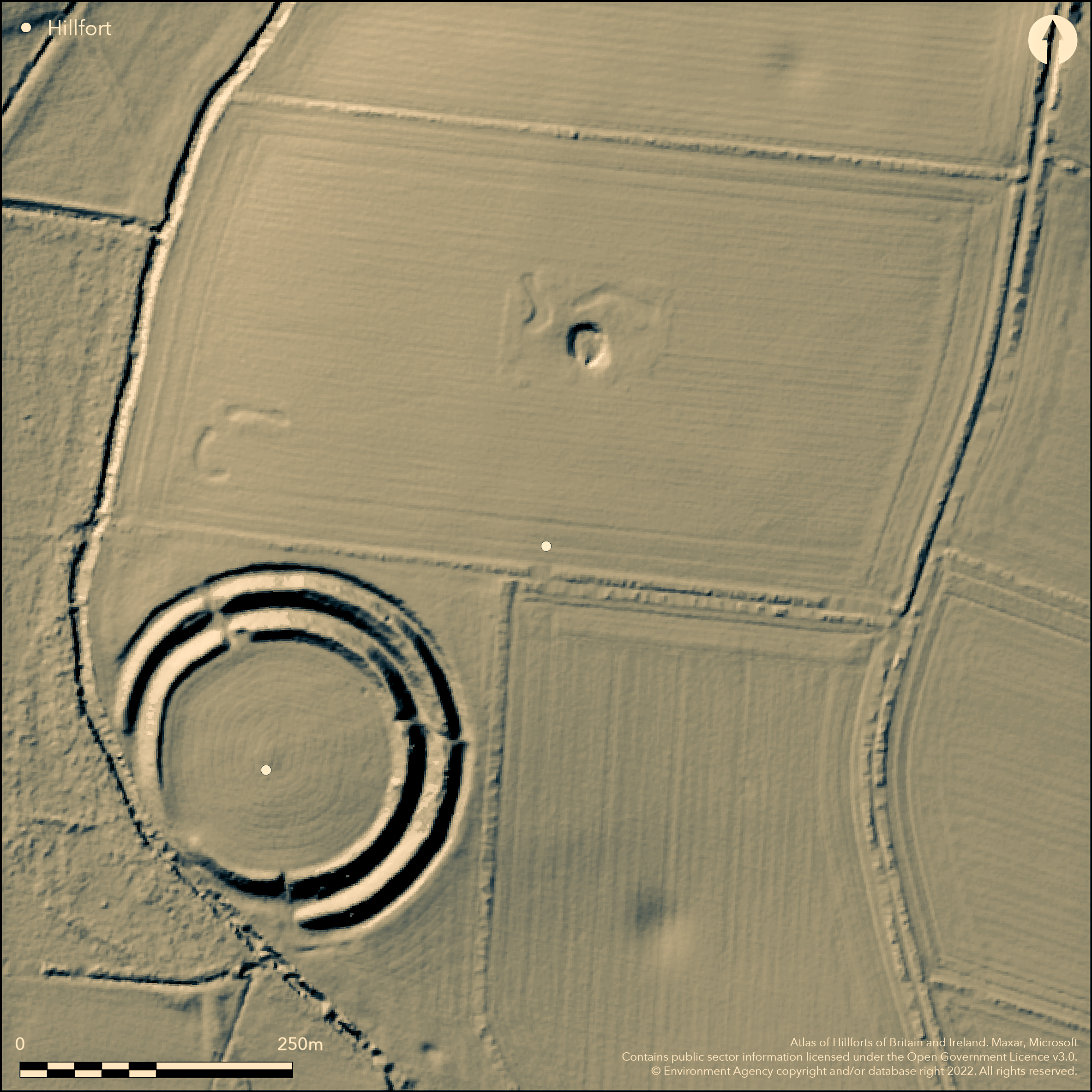
LiDAR 1m DTM Hillshade
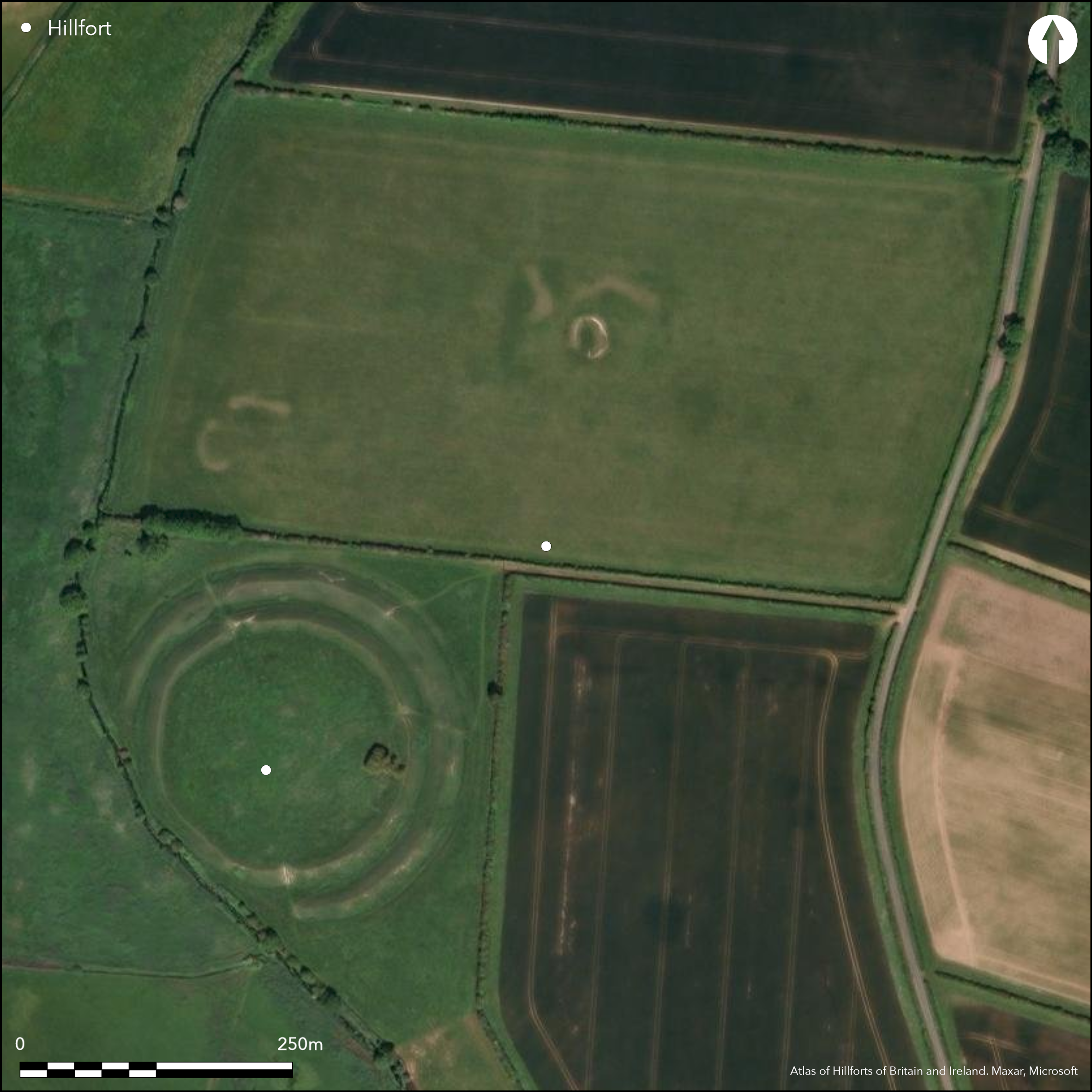
Satellite Imagery
LiDAR 1m DTM Hillshade
Satellite Imagery
Scroll left/right to view further images.
HER: Norfolk 1827 (None)
NMR: TF 9 4 SW 6 (359245)
SM: 1018016
NGR: TF 9455 4105
X: 594510 Y: 341010 (OSGB36)
Located S of Warham St. Mary on a hilltop overlooking the River Stiffkey, 80m NE of Warham Camp (Atlas No. 2419). Shown on an estate map of 1783 as an earthwork, now ploughed flat and rediscovered as a cropmark by aerial photography in 1953. A nearly rectangular univallate enclosure measuring 70m N-S by 67m E-W, c.0.3ha. Limited excavations carried out in 1959 (Gregory 1986) have shown the ditch was V-shaped in section and between 1.7m and 2m deep measured from the present surface of the ploughsoil. On the W and N sides of the enclosure and around the NE corner it is approximately 2m wide, and on the S side and the E side S of the entrance it is approximately 5.8m wide. The earlier smaller ditch was replaced by a later larger one, the result of re-cutting after the original ditch had become partly infilled. An entrance in the middle of the E side, c.14m wide, a possible second entrance in the W side suggested on aerial photograph. Both phases of the enclosure are poorly dated by late Iron Age and Romano-British pottery from the excavation but 3rd century BC to 1st century AD seems likely. No evidence for internal activity. The excavator (Clarke) suggests this is an unfinished hillfort replaced by nearby Warham Camp but this is disputed by Gregory (1986). A possible hillfort.
Citizen Science: ✗
Reliability of Data: Confirmed
Reliability of Interpretation: Unconfirmed
X: 99366 Y: 6970285 (EPSG: 3857)
Longitude: 0.8926177679390033 Latitude: 52.9312191222386 (EPSG:4326)
Country: England
Current County or Unitary Authority: Norfolk
Historic County: Norfolk
Current Parish/Community/Council/Townland: Wareham
None
| Extant | ✗ |
| Cropmark | ✓ |
| Likely Destroyed | ✗ |
None
| Woodland | ✗ |
| Commercial Forestry Plantation | ✗ |
| Parkland | ✗ |
| Pasture (Grazing) | ✗ |
| Arable | ✓ |
| Scrub/Bracken | ✗ |
| Bare Outcrop | ✗ |
| Heather/Moorland | ✗ |
| Heath | ✗ |
| Built-up | ✗ |
| Coastal Grassland | ✗ |
| Other | ✗ |
On a hilltop overlooking the River Stiffkey valley
| Contour Fort | ✗ |
| Partial Contour Fort | ✓ |
| Promontory Fort | ✗ |
| Hillslope Fort | ✗ |
| Level Terrain Fort | ✗ |
| Marsh Fort | ✗ |
| Multiple Enclosure Fort | ✗ |
| Hilltop | ✓ |
| Coastal Promontory | ✗ |
| Inland Promontory | ✗ |
| Valley Bottom | ✗ |
| Knoll/Hillock/Outcrop | ✗ |
| Ridge | ✗ |
| Cliff/Plateau-edge/Scarp | ✗ |
| Hillslope | ✗ |
| Lowland | ✗ |
| Spur | ✗ |
Dominant Topographic Feature: On a hilltop overlooking the River Stiffkey valley
| North | ✗ |
| Northeast | ✗ |
| East | ✗ |
| Southeast | ✗ |
| South | ✗ |
| Southwest | ✗ |
| West | ✗ |
| Northwest | ✗ |
| Level | ✓ |
Altitude: 15.0m
N/A
Pottery from excavation suggests 3rd century BC to 1st century AD. Neolithic and Beaker pottery, Romano-British pottery
Reliability: B - Medium
| Pre 1200BC | ✗ |
| 1200BC - 800BC | ✗ |
| 800BC - 400BC | ✗ |
| 400BC - AD50 | ✓ |
| AD50 - AD400 | ✓ |
| AD400 - AD 800 | ✗ |
| Post AD800 | ✗ |
| Unknown | ✗ |
| Pre Hillfort: | None |
| Post Hillfort: | None |
| Artefactual: | None |
Shown on an estate map of 1783 as an earthwork, now ploughed flat and rediscovered as a cropmark by aerial photography in 1953. geophysics and excavation in 1959
| 1st Identified Map Depiction (1783): | None |
| Other (1953): | None |
| Geophysical Survey (1959): | None |
| Excavation (1959): | None |
No evidence for interior activity, pottery and animal bone from excavation.
None
| None | ✓ |
| Spring | ✗ |
| Stream | ✗ |
| Pool | ✗ |
| Flush | ✗ |
| Well | ✗ |
| Other | ✗ |
None
| No Known Features | ✓ |
| Round Stone Structures | ✗ |
| Rectangular Stone Structures | ✗ |
| Curvilinear Platforms | ✗ |
| Other Roundhouse Evidence | ✗ |
| Pits | ✗ |
| Quarry Hollows | ✗ |
| Other | ✗ |
None
| No Known Excavation | ✗ |
| Pits | ✗ |
| Postholes | ✗ |
| Roundhouses | ✗ |
| Rectangular Structures | ✗ |
| Roads/Tracks | ✗ |
| Quarry Hollows | ✗ |
| Other | ✗ |
| Nothing Found | ✓ |
None
| No Known Geophysics | ✗ |
| Pits | ✗ |
| Roundhouses | ✗ |
| Rectangular Structures | ✗ |
| Roads/Tracks | ✗ |
| Quarry Hollows | ✗ |
| Other | ✓ |
| Nothing Found | ✗ |
None
| No Known Finds | ✗ |
| Pottery | ✓ |
| Metal | ✗ |
| Metalworking | ✗ |
| Human Bones | ✗ |
| Animal Bones | ✓ |
| Lithics | ✗ |
| Environmental | ✗ |
| Other | ✗ |
NO APPARENT FEATURES
| APs Not Checked | ✗ |
| None | ✓ |
| Roundhouses | ✗ |
| Rectangular Structures | ✗ |
| Pits | ✗ |
| Postholes | ✗ |
| Roads/Tracks | ✗ |
| Other | ✗ |
An entrance in the middle of the E side, c.14m wide, a possible second entrance in the W side suggested on aerial photograph.
| 2: | None |
| 2: | None |
Guard Chambers: ✗
Chevaux de Frise: ✗
| 1. Simple Gap (East): | None |
| 2. Simple Gap (West): | None |
A single bank and ditch, now ploughed flat. Excavation has shown the ditch to be two phased, V-shaped in section and between 1.7m and 2m deep measured from the present surface of the ploughsoil. On the W and N sides of the enclosure and around the NE corner it is approximately 2m wide, and on the S side and the E side S of the entrance it is approximately 5.8m wide.
| Area 1: | 0.3ha. |
| Total: | 0.3ha. |
Total Footprint Area: Noneha.
None
| ✗ | None |
| ✓ | None |
| NE Quadrant: | 1 |
| SE Quadrant: | 1 |
| SW Quadrant: | 1 |
| NW Quadrant: | 1 |
| Total: | 1 |
| Partial Univallate | ✗ |
| Univallate | ✓ |
| Partial Bivallate | ✗ |
| Bivallate | ✗ |
| Partial Multivallate | ✗ |
| Multivallate | ✗ |
| Unknown | ✗ |
| Partial Univallate | ✗ |
| Univallate | ✗ |
| Partial Bivallate | ✗ |
| Bivallate | ✗ |
| Partial Multivallate | ✗ |
| Multivallate | ✗ |
None
| None | ✓ |
| Earthen Bank | ✗ |
| Stone Wall | ✗ |
| Rubble | ✗ |
| Wall-walk | ✗ |
| Evidence of Timber | ✗ |
| Vitrification | ✗ |
| Other Burning | ✗ |
| Palisade | ✗ |
| Counter Scarp Bank | ✗ |
| Berm | ✗ |
| Unfinished | ✗ |
| Other | ✗ |
None
| None | ✓ |
| Earthen Bank | ✗ |
| Stone Wall | ✗ |
| Murus Duplex | ✗ |
| Timber-framed | ✗ |
| Timber-laced | ✗ |
| Vitrification | ✗ |
| Other Burning | ✗ |
| Palisade | ✗ |
| Counter Scarp Bank | ✗ |
| Berm | ✗ |
| Unfinished | ✗ |
| No Known Excavation | ✗ |
| Other | ✗ |
| ✗ | None |
| ✓ | None |
Number of Ditches: 1
| ✗ | None |
Gregory, T. 1986. Warham Burrows, in Excavations at Thornham, Warham, Wighton and Caister, Norfolk, E Anglian Archaeol Rep. No. 30, 17-21.
Atlas of Hillforts:
Wikidata:
This work is licensed under CC BY-SA 4.0

 and should be cited as:
Lock, Gary and Ralston, Ian. 2024. Atlas of Hillforts of Britain and Ireland. Available at: https://hillforts.arch.ox.ac.uk
Document Version 1.1