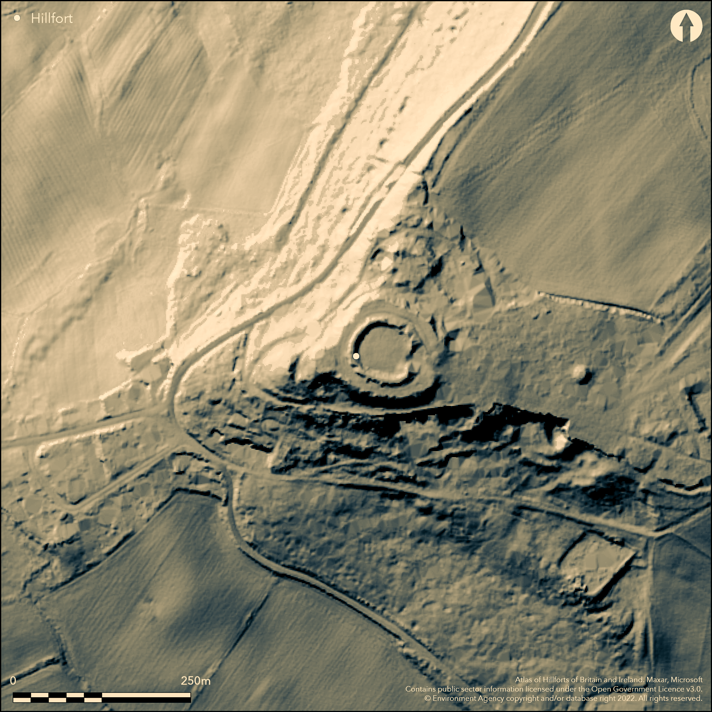
LiDAR 1m DTM Hillshade
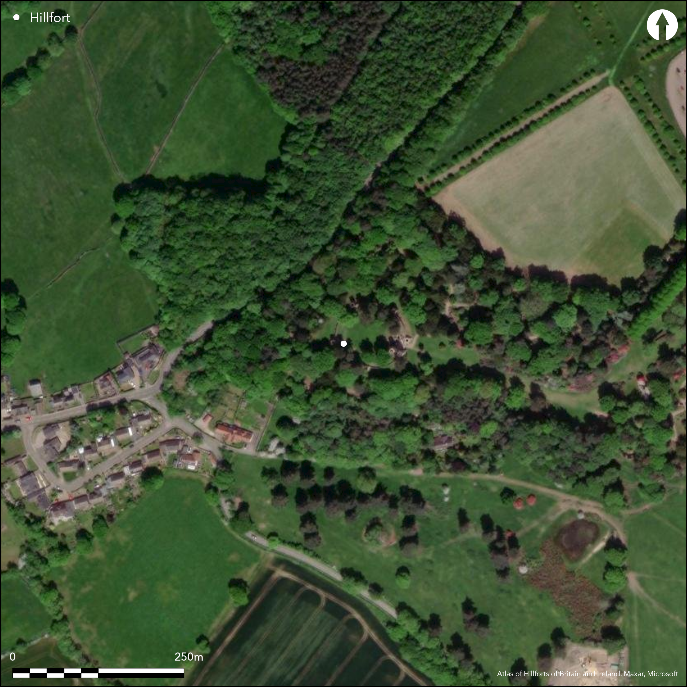
Satellite Imagery
LiDAR 1m DTM Hillshade
Satellite Imagery
Scroll left/right to view further images.
HER: South Yorkshire 00587/02 (None)
NMR: SE 30 SW 3 (52458)
SM: None
NGR: SE 3153 0305
X: 431530 Y: 403050 (OSGB36)
Lying at the end of a promontory on the summit of Stainborough Low with commanding views in all directions, a bank and ditched enclosure interpreted as a possible hillfort (Hunter 1831, Preston 1954, Birch 1980, Ashurst 1991). The earthworks that survive today are consistent with those of hillforts in the area, but might be medieval with further modifications resulting from the landscaping in the grounds of Wentworth Castle for an 18th century garden folly called Stainborough Castle. Today, the overlying earthworks have the form of a medieval mott 50m in diameter. In 1966 a 1m wide trench across what was believed to be the line of the defensive ditch recovered material from a ha-ha and revealed the bank of the ditch and a single fragment of Iron Age pottery. A further excavation in 1991 showed the ditch to have a V-shaped profile. The excavation of seven trenches in 2005 within the centre of Stainborough Castle failed to produce anything earlier than the construction of the 18th century folly (Rose and Prudhoe 2005). Geophysical surveys in 2006 recorded a linear anomaly on the line of the ditch. A topographical survey of Stainborough Castle (Pollington, 2006) suggests that the extensive earthwork terraces on which Stainborough Castle stands pre-date its construction although it remains inconclusive as to whether it was an Iron Age hillfort or a medieval fortification. During this survey a bank approximately 1.5m high an 9.5m wide, with a ditch approximately 2m deep and 9.5m wide on its eastern side was recorded to the N of the folly and a further section surviving as a slight depression 0.1-0.3m deep and approximately 4m wide. A possible fortification was first recorded on this site in the Domesday survey of 1086 and described in the Court Roll of James I (1613) as castle ruins called Staynbroughe Lowe. Eighteenth century engravings and an estate map appear to show multiple vallation (further discussion of the cartographic and documentary sources is given in Pollington 2006). The find of a single undated flint fragment from the W of the site, suggest possible prehistoric activity. It is listed in Hogg as 'Stainbrough Low' a univallate hillfort covering 0.80ha. Recorded on 1885-1900 OS mapping.
Citizen Science: ✗
Reliability of Data: Confirmed
Reliability of Interpretation: Unconfirmed
X: -169861 Y: 7080362 (EPSG: 3857)
Longitude: -1.5258860581337197 Latitude: 53.5231687341536 (EPSG:4326)
Country: England
Current County or Unitary Authority: South Yorkshire
Historic County: Yorkshire
Current Parish/Community/Council/Townland: Stainborough
Some destruction has occurred through landscaping
| Extant | ✓ |
| Cropmark | ✗ |
| Likely Destroyed | ✓ |
None
| Woodland | ✗ |
| Commercial Forestry Plantation | ✗ |
| Parkland | ✓ |
| Pasture (Grazing) | ✗ |
| Arable | ✗ |
| Scrub/Bracken | ✗ |
| Bare Outcrop | ✗ |
| Heather/Moorland | ✗ |
| Heath | ✗ |
| Built-up | ✗ |
| Coastal Grassland | ✗ |
| Other | ✗ |
Situated at 200m on level ground on the highest point of a promontory
| Contour Fort | ✓ |
| Partial Contour Fort | ✗ |
| Promontory Fort | ✗ |
| Hillslope Fort | ✗ |
| Level Terrain Fort | ✗ |
| Marsh Fort | ✗ |
| Multiple Enclosure Fort | ✗ |
| Hilltop | ✗ |
| Coastal Promontory | ✗ |
| Inland Promontory | ✓ |
| Valley Bottom | ✗ |
| Knoll/Hillock/Outcrop | ✗ |
| Ridge | ✗ |
| Cliff/Plateau-edge/Scarp | ✗ |
| Hillslope | ✗ |
| Lowland | ✗ |
| Spur | ✗ |
Dominant Topographic Feature: Natural promontory
| North | ✗ |
| Northeast | ✗ |
| East | ✗ |
| Southeast | ✗ |
| South | ✗ |
| Southwest | ✗ |
| West | ✗ |
| Northwest | ✗ |
| Level | ✓ |
Altitude: 200.0m
N/A
There is considerable uncertainty over the date of the bank and ditch features and could be prehistoric or medieval
Reliability: D - None
| Pre 1200BC | ✗ |
| 1200BC - 800BC | ✗ |
| 800BC - 400BC | ✗ |
| 400BC - AD50 | ✗ |
| AD50 - AD400 | ✗ |
| AD400 - AD 800 | ✗ |
| Post AD800 | ✗ |
| Unknown | ✓ |
| Pre Hillfort: | None |
| Post Hillfort: | Folly and garden landscaping |
Field investigation in 1964. In 1966 a 1m wide trench across the line of the defensive ditch revealed the bank of the ditch. A further excavation in 1991 showed the ditch to have a V-shaped profile. Seven trenches in 2005 within the centre of Stainborough Castle failed to produce anything earlier than the construction of the 18th century folly (Rose and Prudhoe 2005). Geophysical surveys in 2006 recorded a linear anomaly on the line of the ditch. A topographical survey of Stainborough Castle was carried out using a Total Station in 2006
| Domesday (1086): | None |
| 1st Identified Written Reference (1831): | None |
| Other (1964): | Field investigation |
| Excavation (1966): | None |
| Excavation (1981): | None |
| Earthwork Survey (2006): | ASWYAS |
| Geophysical Survey (2006): | None |
| 1st Identified Map Depiction (None): | None |
No evidence for interior features
None
| None | ✓ |
| Spring | ✗ |
| Stream | ✗ |
| Pool | ✗ |
| Flush | ✗ |
| Well | ✗ |
| Other | ✗ |
None
| No Known Features | ✓ |
| Round Stone Structures | ✗ |
| Rectangular Stone Structures | ✗ |
| Curvilinear Platforms | ✗ |
| Other Roundhouse Evidence | ✗ |
| Pits | ✗ |
| Quarry Hollows | ✗ |
| Other | ✗ |
None
| No Known Excavation | ✓ |
| Pits | ✗ |
| Postholes | ✗ |
| Roundhouses | ✗ |
| Rectangular Structures | ✗ |
| Roads/Tracks | ✗ |
| Quarry Hollows | ✗ |
| Other | ✗ |
| Nothing Found | ✗ |
None
| No Known Geophysics | ✓ |
| Pits | ✗ |
| Roundhouses | ✗ |
| Rectangular Structures | ✗ |
| Roads/Tracks | ✗ |
| Quarry Hollows | ✗ |
| Other | ✗ |
| Nothing Found | ✗ |
None
| No Known Finds | ✓ |
| Pottery | ✗ |
| Metal | ✗ |
| Metalworking | ✗ |
| Human Bones | ✗ |
| Animal Bones | ✗ |
| Lithics | ✗ |
| Environmental | ✗ |
| Other | ✗ |
NO APPARENT FEATURES
| APs Not Checked | ✗ |
| None | ✓ |
| Roundhouses | ✗ |
| Rectangular Structures | ✗ |
| Pits | ✗ |
| Postholes | ✗ |
| Roads/Tracks | ✗ |
| Other | ✗ |
No evidence for entrances
| None: | None |
| 2: | None |
Guard Chambers: ✗
Chevaux de Frise: ✗
Evidence for Iron Age enclosing works is confused by medieval activity
| Area 1: | 0.8ha. |
| Total: | 0.8ha. |
Total Footprint Area: Noneha.
None
| ✗ | None |
| ✗ | None |
| NE Quadrant: | None |
| SE Quadrant: | None |
| SW Quadrant: | None |
| NW Quadrant: | None |
| Total: | None |
| Partial Univallate | ✗ |
| Univallate | ✗ |
| Partial Bivallate | ✗ |
| Bivallate | ✗ |
| Partial Multivallate | ✗ |
| Multivallate | ✗ |
| Unknown | ✓ |
| Partial Univallate | ✗ |
| Univallate | ✗ |
| Partial Bivallate | ✗ |
| Bivallate | ✗ |
| Partial Multivallate | ✗ |
| Multivallate | ✗ |
None
| None | ✗ |
| Earthen Bank | ✓ |
| Stone Wall | ✗ |
| Rubble | ✗ |
| Wall-walk | ✗ |
| Evidence of Timber | ✗ |
| Vitrification | ✗ |
| Other Burning | ✗ |
| Palisade | ✗ |
| Counter Scarp Bank | ✗ |
| Berm | ✗ |
| Unfinished | ✗ |
| Other | ✗ |
Ditch excavated
| None | ✗ |
| Earthen Bank | ✗ |
| Stone Wall | ✗ |
| Murus Duplex | ✗ |
| Timber-framed | ✗ |
| Timber-laced | ✗ |
| Vitrification | ✗ |
| Other Burning | ✗ |
| Palisade | ✗ |
| Counter Scarp Bank | ✗ |
| Berm | ✗ |
| Unfinished | ✗ |
| No Known Excavation | ✗ |
| Other | ✓ |
| ✗ | None |
| ✓ | None |
Number of Ditches: 1
| ✗ | None |
Ashurst, D., 1991, Stainborough Lowe, Trans Hunter Archaeol Soc, 16, 33-8
Birch, J., 1980, Stainborough Castle, Archaeol J 137, 448-9
Hunter, J., 1831. South Yorkshire: the History and Topography of the Deanery of Doncaster, Volume I. London: J.B. Nichols and Son.
Pollington, M. 2006. Stainborough Castle, Wentworth Castle, Barnsley, South Yorkshire: Archaeological Topographical Survey. Morley: Archaeological Services WYAS, Report No. 1529. Unpublished
Preston, F.L., 1954. Hillforts of the Peak, Derbyshire Archaeol J , 74, 14
Rose, M. and Prudhoe, J., 2005. Stainborough Castle: Archaeological Evaluation and Fabric Survey, ASWYAS report no. 1360. Unpublished
Hogg, A.H.A.1979. British Hill-Forts. An Index. British Archaeological Reports, British Series 62
Atlas of Hillforts:
Wikidata:
This work is licensed under CC BY-SA 4.0

 and should be cited as:
Lock, Gary and Ralston, Ian. 2024. Atlas of Hillforts of Britain and Ireland. Available at: https://hillforts.arch.ox.ac.uk
Document Version 1.1