LiDAR 1m DTM Hillshade
Satellite Imagery
LiDAR 1m DTM Hillshade
Satellite Imagery
Scroll left/right to view further images.
HER: North Yorkshire MNY21030 (None)
NMR: SE 27 NE 15 (52079)
SM: 1017467
NGR: SE 2913 7558
X: 429130 Y: 475580 (OSGB36)
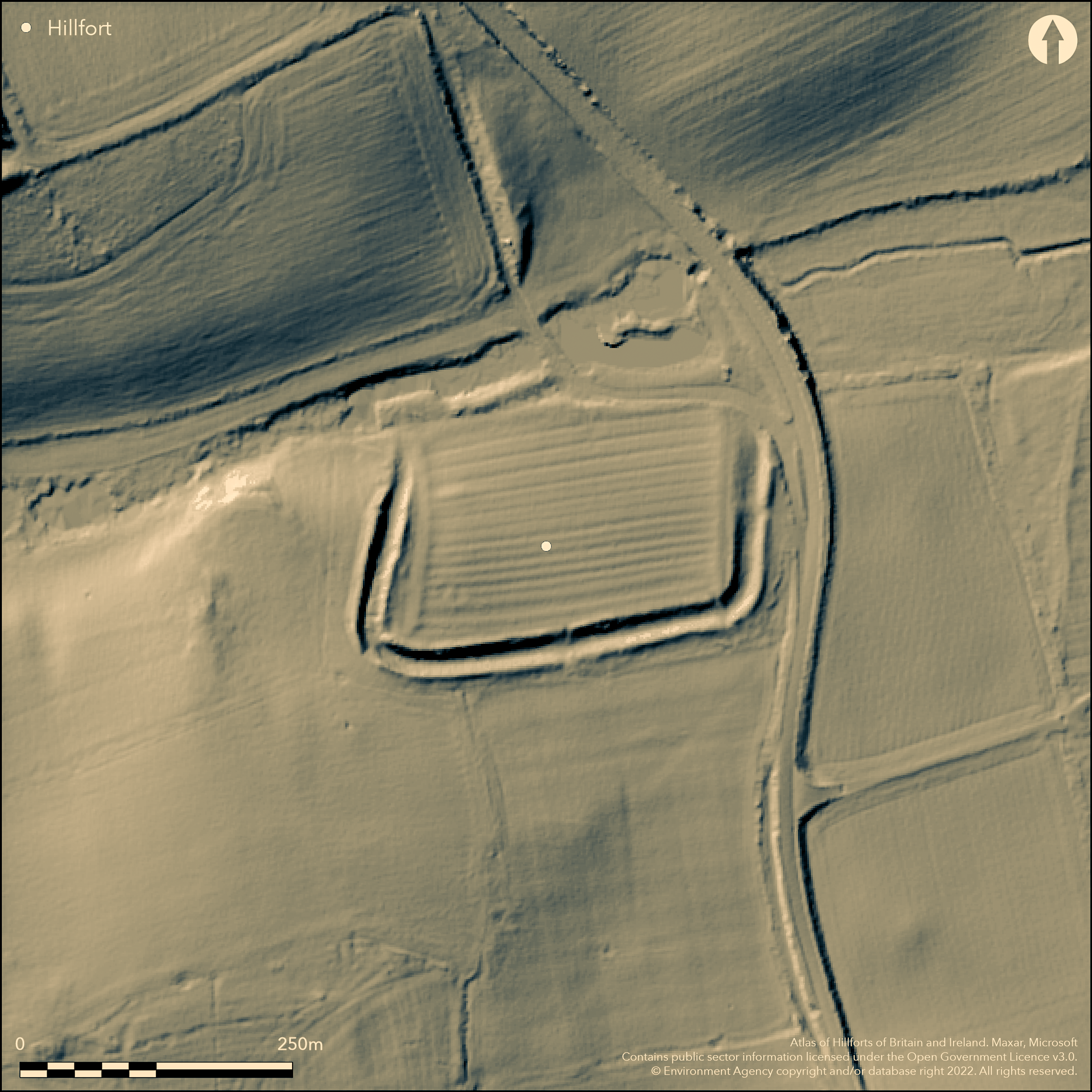
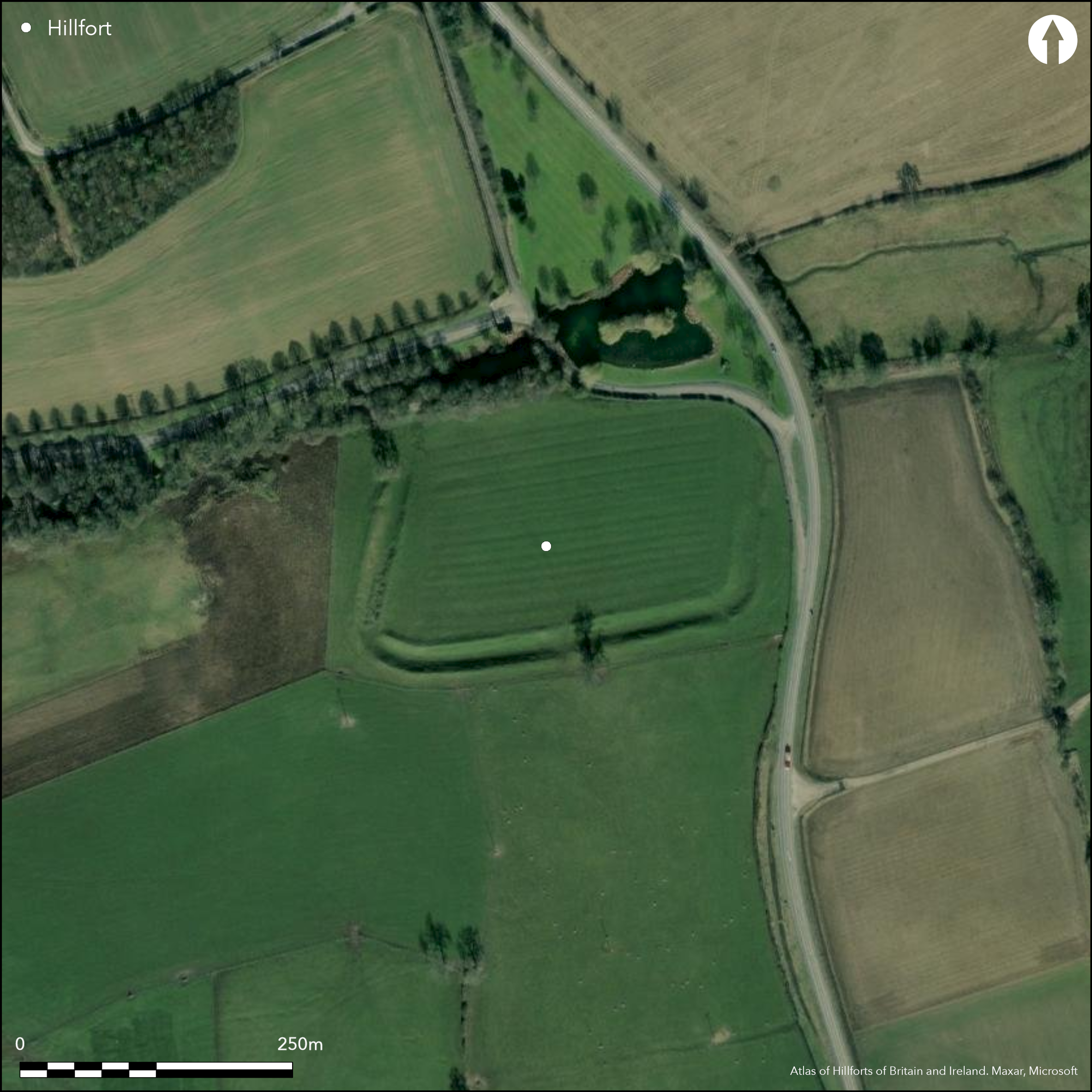
Lying 1km to the SE of North Stanley, an enclosure of 2ha, possibly an Iron Age hillfort. The site was considered to be the defensive enclosure of a Roman villa constructed and occupied c. AD 120 into the late 3rd century, which is visible as parchmarks within the interior. Road widening in 1929 showed further unsuspected foundations that are probably contemporary with the villa. Three circular features are also visible, one of which is complete. An RCHME survey in 1963 concluded that the earthworks were not Roman in character and possibly an adaptation in the Roman period of an Iron Age hillfort, but could be an early post Roman addition. The enclosure measures 200m E-W by 110m transversely and is bounded in the E, S and W by a pair of earth and stone built banks separated by a deep ditch. The outer bank is up to 8m wide and 1m high, the inner bank up to 3.5m wide and 1.5m high, possibly a counterscarp. The ditch is 11m wide and up to 2.9m deep. Any earthworks in the N were destroyed by the construction of the modern road, but it might originally have been protected by marshy ground and the Light Water stream. Lowered sections of banks in the E and S sides are considered to be the remains of entrances. The site is scheduled as Castle Dikes defended Roman villa. It is recorded on 1885-1900 OS mapping as Castle Dikes Camp.
Citizen Science: ✗
Reliability of Data: Confirmed
Reliability of Interpretation: Unconfirmed
X: -173127 Y: 7203406 (EPSG: 3857)
Longitude: -1.5552283716560165 Latitude: 54.175191756174456 (EPSG:4326)
Country: England
Current County or Unitary Authority: North Yorkshire
Historic County: Yorkshire
Current Parish/Community/Council/Townland: North Stainley with Sleningford
Extant in the E, S and W.
| Extant | ✓ |
| Cropmark | ✗ |
| Likely Destroyed | ✗ |
Plough lines seen on satellite imagery seem to be contained within the interior
| Woodland | ✗ |
| Commercial Forestry Plantation | ✗ |
| Parkland | ✗ |
| Pasture (Grazing) | ✗ |
| Arable | ✓ |
| Scrub/Bracken | ✗ |
| Bare Outcrop | ✗ |
| Heather/Moorland | ✗ |
| Heath | ✗ |
| Built-up | ✗ |
| Coastal Grassland | ✗ |
| Other | ✗ |
A lowland, level terrain fort. The site lies on almost level ground at 53m OD, with the ground rising in the SW angle of the enclosure
| Contour Fort | ✗ |
| Partial Contour Fort | ✗ |
| Promontory Fort | ✗ |
| Hillslope Fort | ✗ |
| Level Terrain Fort | ✓ |
| Marsh Fort | ✗ |
| Multiple Enclosure Fort | ✗ |
| Hilltop | ✗ |
| Coastal Promontory | ✗ |
| Inland Promontory | ✗ |
| Valley Bottom | ✗ |
| Knoll/Hillock/Outcrop | ✗ |
| Ridge | ✗ |
| Cliff/Plateau-edge/Scarp | ✗ |
| Hillslope | ✗ |
| Lowland | ✓ |
| Spur | ✗ |
Dominant Topographic Feature: Almost level ground
| North | ✗ |
| Northeast | ✗ |
| East | ✗ |
| Southeast | ✗ |
| South | ✗ |
| Southwest | ✗ |
| West | ✗ |
| Northwest | ✗ |
| Level | ✓ |
Altitude: 53.0m
N/A
Only the Roman period villa has been dated, the date of the enclosing works is unknown.
Reliability: D - None
| Pre 1200BC | ✗ |
| 1200BC - 800BC | ✗ |
| 800BC - 400BC | ✗ |
| 400BC - AD50 | ✗ |
| AD50 - AD400 | ✗ |
| AD400 - AD 800 | ✗ |
| Post AD800 | ✗ |
| Unknown | ✓ |
| Pre Hillfort: | None |
| Post Hillfort: | Roman villa |
Recorded on 1885-1900 OS mapping. RCHME field investigations in 1962 and 1963. Scheduled as an enclosure defending a Roman villa
| Other (1926): | Scheduled |
| Other (1962): | Field investigation |
| Other (1963): | Field investigation |
| 1st Identified Map Depiction (None): | None |
The parchmarks of a Roman villa can be seen within the interior. Three circular features are also visible, one of which is complete
The Light Water stream lies to the N.
| None | ✓ |
| Spring | ✗ |
| Stream | ✗ |
| Pool | ✗ |
| Flush | ✗ |
| Well | ✗ |
| Other | ✗ |
Roman villa
| No Known Features | ✗ |
| Round Stone Structures | ✗ |
| Rectangular Stone Structures | ✗ |
| Curvilinear Platforms | ✓ |
| Other Roundhouse Evidence | ✗ |
| Pits | ✗ |
| Quarry Hollows | ✗ |
| Other | ✓ |
None
| No Known Excavation | ✓ |
| Pits | ✗ |
| Postholes | ✗ |
| Roundhouses | ✗ |
| Rectangular Structures | ✗ |
| Roads/Tracks | ✗ |
| Quarry Hollows | ✗ |
| Other | ✗ |
| Nothing Found | ✗ |
None
| No Known Geophysics | ✓ |
| Pits | ✗ |
| Roundhouses | ✗ |
| Rectangular Structures | ✗ |
| Roads/Tracks | ✗ |
| Quarry Hollows | ✗ |
| Other | ✗ |
| Nothing Found | ✗ |
None
| No Known Finds | ✓ |
| Pottery | ✗ |
| Metal | ✗ |
| Metalworking | ✗ |
| Human Bones | ✗ |
| Animal Bones | ✗ |
| Lithics | ✗ |
| Environmental | ✗ |
| Other | ✗ |
None
| APs Not Checked | ✓ |
| None | ✗ |
| Roundhouses | ✗ |
| Rectangular Structures | ✗ |
| Pits | ✗ |
| Postholes | ✗ |
| Roads/Tracks | ✗ |
| Other | ✗ |
Lowered sections of banks in the E and S sides are considered to be the remains of entrances
| 2: | None |
| 2: | None |
Guard Chambers: ✗
Chevaux de Frise: ✗
| 1. Other Forms (East): | None |
| 2. Other Forms (South): | None |
Rectilinear enclosure 200m E-W by 110m transversely. Bounded in the E, S and W by a double bank and a wide intermediate ditch. Any defences in the N were destroyed by the construction of the modern road, but originally it might have been protected by marshy ground and the Light Water Stream. The ramparts consist of a pair of earth and stone banks separated by a deep ditch. The outer bank is up to 8m wide and 1m high, the inner bank up to 3.5m wide and 1.5m high. The ditch is 11m wide and up to 2.9m deep.
| Area 1: | 2.0ha. |
| Total: | 2.0ha. |
Total Footprint Area: Noneha.
None
| ✗ | None |
| ✗ | None |
| NE Quadrant: | 2 |
| SE Quadrant: | 2 |
| SW Quadrant: | 2 |
| NW Quadrant: | None |
| Total: | 2 |
| Partial Univallate | ✗ |
| Univallate | ✗ |
| Partial Bivallate | ✓ |
| Bivallate | ✗ |
| Partial Multivallate | ✗ |
| Multivallate | ✗ |
| Unknown | ✗ |
| Partial Univallate | ✗ |
| Univallate | ✗ |
| Partial Bivallate | ✗ |
| Bivallate | ✗ |
| Partial Multivallate | ✗ |
| Multivallate | ✗ |
Possible counterscarp
| None | ✗ |
| Earthen Bank | ✓ |
| Stone Wall | ✓ |
| Rubble | ✗ |
| Wall-walk | ✗ |
| Evidence of Timber | ✗ |
| Vitrification | ✗ |
| Other Burning | ✗ |
| Palisade | ✗ |
| Counter Scarp Bank | ✓ |
| Berm | ✗ |
| Unfinished | ✗ |
| Other | ✗ |
None
| None | ✗ |
| Earthen Bank | ✗ |
| Stone Wall | ✗ |
| Murus Duplex | ✗ |
| Timber-framed | ✗ |
| Timber-laced | ✗ |
| Vitrification | ✗ |
| Other Burning | ✗ |
| Palisade | ✗ |
| Counter Scarp Bank | ✗ |
| Berm | ✗ |
| Unfinished | ✗ |
| No Known Excavation | ✓ |
| Other | ✗ |
| ✗ | None |
| ✓ | None |
Number of Ditches: 1
| ✗ | None |
Luckis, W. C. 1875. Castle-Dykes. Archaeol J. Vol 32, 134-154
Atlas of Hillforts:
Wikidata:
This work is licensed under CC BY-SA 4.0![]()
![]()
![]() and should be cited as:
and should be cited as:
Lock, Gary and Ralston, Ian. 2024. Atlas of Hillforts of Britain and Ireland. Available at: https://hillforts.arch.ox.ac.uk
Document Version 1.1