LiDAR 1m DTM Hillshade
Satellite Imagery
LiDAR 1m DTM Hillshade
Satellite Imagery
Scroll left/right to view further images.
HER: Yorkshire Dales National Park MYD5144 (30652*0 (NT))
NMR: SE 18 NW 16 (50913)
SM: 1009321
NGR: SE 1200 8540
X: 412000 Y: 485400 (OSGB36)
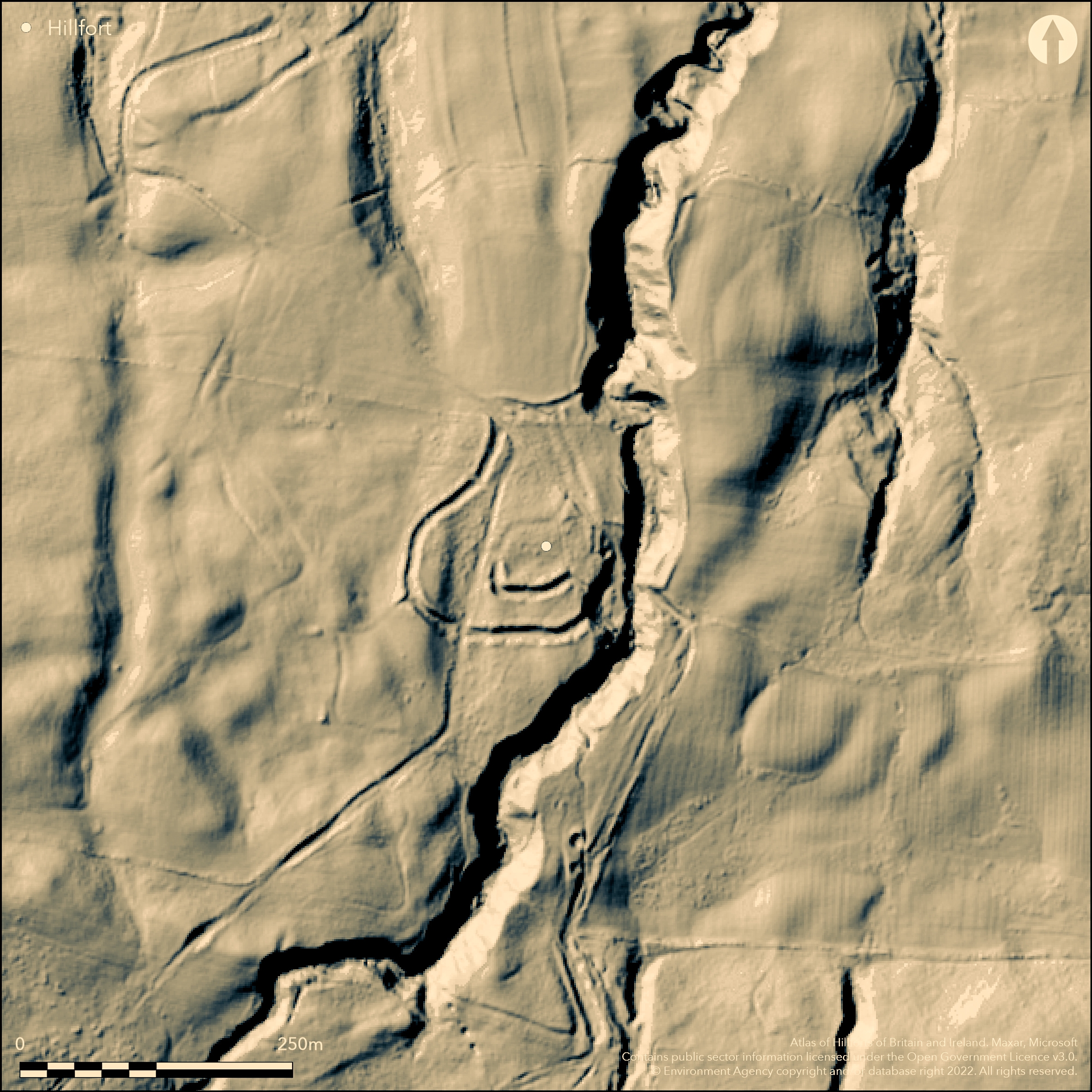
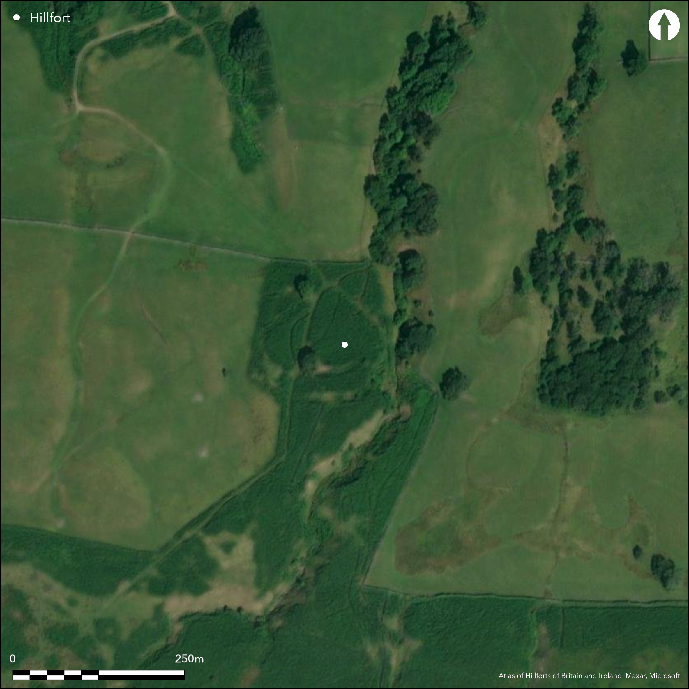
Lying on a N-facing slope at approximately 262m OD on Braithwaite Banks, to the W of Braithwaite Wood, an enclosure scheduled as a slight univallate hillfort. Approximately pear-shaped and widest in the S, the site is defended in the N S and W by a bank and outer ditch enclosing 0.9ha. Red Beck Gill lies to the E. A further bank or counterscarp has been recorded in the N and W. Its location offers extensive views to the E and N and more limited views to the W. The banks are slight, less than 2m high and constructed with a stone core with entrances in the NW corner and in the middle of the S side. The entrance in the S is reported to be revetted on the W side with large boulders and infilled and widened on the E to carry a modern track. Bowden (1996.) believes the revetting to be the remains of an old field wall which crosses the site. This entrance was considered during scheduling to have a more modern appearance, however Bowden suggests neither of these entrances are original, with the original entrance possibly lying within what is now a quarried area. Internally a sub-rectangular ditched and banked enclosure 45m square and probably unfinished on the northern side, with an entrance in the W, lies towards the SW corner. No hut platforms have been recorded. The interior has been ploughed in the past and disturbed by later trackways and drains, and quarrying has destroyed the SE corner. The site is considered by Bowden to be indefensible, having slight banks and he suggests it is a later prehistoric enclosed settlement. Recorded on 1883-1913 OS mapping.
Citizen Science: ✗
Reliability of Data: Confirmed
Reliability of Interpretation: Confirmed
X: -202297 Y: 7220339 (EPSG: 3857)
Longitude: -1.817267259833914 Latitude: 54.26413176691891 (EPSG:4326)
Country: England
Current County or Unitary Authority: North Yorkshire
Historic County: Yorkshire
Current Parish/Community/Council/Townland: East Witton
Owned by the National Trust (Mon no. 30652*0) within the Yorkshire Dales National Park
| Extant | ✓ |
| Cropmark | ✗ |
| Likely Destroyed | ✓ |
None
| Woodland | ✗ |
| Commercial Forestry Plantation | ✗ |
| Parkland | ✗ |
| Pasture (Grazing) | ✗ |
| Arable | ✗ |
| Scrub/Bracken | ✓ |
| Bare Outcrop | ✗ |
| Heather/Moorland | ✗ |
| Heath | ✗ |
| Built-up | ✗ |
| Coastal Grassland | ✗ |
| Other | ✗ |
A hillslope fort lying on a N-facing hillslope at between 255m and 271m OD
| Contour Fort | ✗ |
| Partial Contour Fort | ✗ |
| Promontory Fort | ✗ |
| Hillslope Fort | ✓ |
| Level Terrain Fort | ✗ |
| Marsh Fort | ✗ |
| Multiple Enclosure Fort | ✗ |
| Hilltop | ✗ |
| Coastal Promontory | ✗ |
| Inland Promontory | ✗ |
| Valley Bottom | ✗ |
| Knoll/Hillock/Outcrop | ✗ |
| Ridge | ✗ |
| Cliff/Plateau-edge/Scarp | ✗ |
| Hillslope | ✓ |
| Lowland | ✗ |
| Spur | ✗ |
Dominant Topographic Feature: N-facing hillslope
| North | ✓ |
| Northeast | ✗ |
| East | ✓ |
| Southeast | ✗ |
| South | ✗ |
| Southwest | ✗ |
| West | ✗ |
| Northwest | ✗ |
| Level | ✗ |
Altitude: 262.0m
N/A
Undated
Reliability: D - None
| Pre 1200BC | ✗ |
| 1200BC - 800BC | ✗ |
| 800BC - 400BC | ✗ |
| 400BC - AD50 | ✗ |
| AD50 - AD400 | ✗ |
| AD400 - AD 800 | ✗ |
| Post AD800 | ✗ |
| Unknown | ✓ |
| Pre Hillfort: | None |
| Post Hillfort: | None |
Recorded on 1883-1913 OS mapping. Plan in VCH Yorks. Vol 2 (1912). OS Field investigation in 1977. Earthwork survey 1996. Scheduled
| 1st Identified Written Reference (1912): | None |
| Earthwork Survey (1912): | VCH Yorks |
| Other (1947): | Scheduled |
| Other (1977): | Field investigation |
| Earthwork Survey (1996): | None |
| 1st Identified Map Depiction (None): | None |
Towards the SW corner, a sub-rectangular ditched and banked enclosure 45m square and probably unfinished on the northern side with an entrance in the W.
Red Beck Gill to the E
| None | ✓ |
| Spring | ✗ |
| Stream | ✗ |
| Pool | ✗ |
| Flush | ✗ |
| Well | ✗ |
| Other | ✗ |
Sub-rectangular ditched and banked enclosure
| No Known Features | ✗ |
| Round Stone Structures | ✗ |
| Rectangular Stone Structures | ✗ |
| Curvilinear Platforms | ✗ |
| Other Roundhouse Evidence | ✗ |
| Pits | ✗ |
| Quarry Hollows | ✗ |
| Other | ✓ |
None
| No Known Excavation | ✓ |
| Pits | ✗ |
| Postholes | ✗ |
| Roundhouses | ✗ |
| Rectangular Structures | ✗ |
| Roads/Tracks | ✗ |
| Quarry Hollows | ✗ |
| Other | ✗ |
| Nothing Found | ✗ |
None
| No Known Geophysics | ✓ |
| Pits | ✗ |
| Roundhouses | ✗ |
| Rectangular Structures | ✗ |
| Roads/Tracks | ✗ |
| Quarry Hollows | ✗ |
| Other | ✗ |
| Nothing Found | ✗ |
None
| No Known Finds | ✓ |
| Pottery | ✗ |
| Metal | ✗ |
| Metalworking | ✗ |
| Human Bones | ✗ |
| Animal Bones | ✗ |
| Lithics | ✗ |
| Environmental | ✗ |
| Other | ✗ |
None
| APs Not Checked | ✓ |
| None | ✗ |
| Roundhouses | ✗ |
| Rectangular Structures | ✗ |
| Pits | ✗ |
| Postholes | ✗ |
| Roads/Tracks | ✗ |
| Other | ✗ |
Breaks in the NW corner and in the middle of the S side. The entrance in the S considered a later addition, has been widened on the E to carry a modern track. Bowden (1996) believes neither of these entrances to be original, with the original entrance possibly lying within what is now a quarried area.
| 2: | None |
| 2: | Doubtful |
Guard Chambers: ✗
Chevaux de Frise: ✗
Approximately pear-shaped and widest in the S. The site is defended in the N S and W by a bank and outer ditch enclosing 0.9ha. A further bank or counterscarp has been recorded in the N and W. The banks are slight, less than 2m high and constructed with a stone core.
| Area 1: | 0.9ha. |
| Total: | 0.9ha. |
Total Footprint Area: Noneha.
None
| ✗ | None |
| ✗ | Only in N, S and W. Red Beck Gill lies to the E. A second bank in the N and W is possibly a counterscarp |
| NE Quadrant: | None |
| SE Quadrant: | 1 |
| SW Quadrant: | 1 |
| NW Quadrant: | 1 |
| Total: | 1 |
| Partial Univallate | ✓ |
| Univallate | ✗ |
| Partial Bivallate | ✗ |
| Bivallate | ✗ |
| Partial Multivallate | ✗ |
| Multivallate | ✗ |
| Unknown | ✗ |
| Partial Univallate | ✗ |
| Univallate | ✗ |
| Partial Bivallate | ✗ |
| Bivallate | ✗ |
| Partial Multivallate | ✗ |
| Multivallate | ✗ |
Appears to be turf covered. Reports describe the banks as having a stone core.
| None | ✗ |
| Earthen Bank | ✓ |
| Stone Wall | ✓ |
| Rubble | ✗ |
| Wall-walk | ✗ |
| Evidence of Timber | ✗ |
| Vitrification | ✗ |
| Other Burning | ✗ |
| Palisade | ✗ |
| Counter Scarp Bank | ✓ |
| Berm | ✗ |
| Unfinished | ✗ |
| Other | ✗ |
None
| None | ✗ |
| Earthen Bank | ✗ |
| Stone Wall | ✗ |
| Murus Duplex | ✗ |
| Timber-framed | ✗ |
| Timber-laced | ✗ |
| Vitrification | ✗ |
| Other Burning | ✗ |
| Palisade | ✗ |
| Counter Scarp Bank | ✗ |
| Berm | ✗ |
| Unfinished | ✗ |
| No Known Excavation | ✓ |
| Other | ✗ |
| ✗ | None |
| ✓ | None |
Number of Ditches: 1
| ✗ | None |
Bowden, M. 1996. Maiden Castle Swaledale Survey. RCHME/16-JUL-1996/
Page, W. 1912 The Victoria History of the County of York, II .pp.7-8
Atlas of Hillforts:
Wikidata:
This work is licensed under CC BY-SA 4.0![]()
![]()
![]() and should be cited as:
and should be cited as:
Lock, Gary and Ralston, Ian. 2024. Atlas of Hillforts of Britain and Ireland. Available at: https://hillforts.arch.ox.ac.uk
Document Version 1.1