LiDAR 1m DTM Hillshade
Satellite Imagery
LiDAR 1m DTM Hillshade
Satellite Imagery
Scroll left/right to view further images.
HER: National Trust 13001 (None)
NMR: NZ 08 NW 2 (20972)
SM: None
NGR: NZ 0422 8850
X: 404221 Y: 588505 (OSGB36)
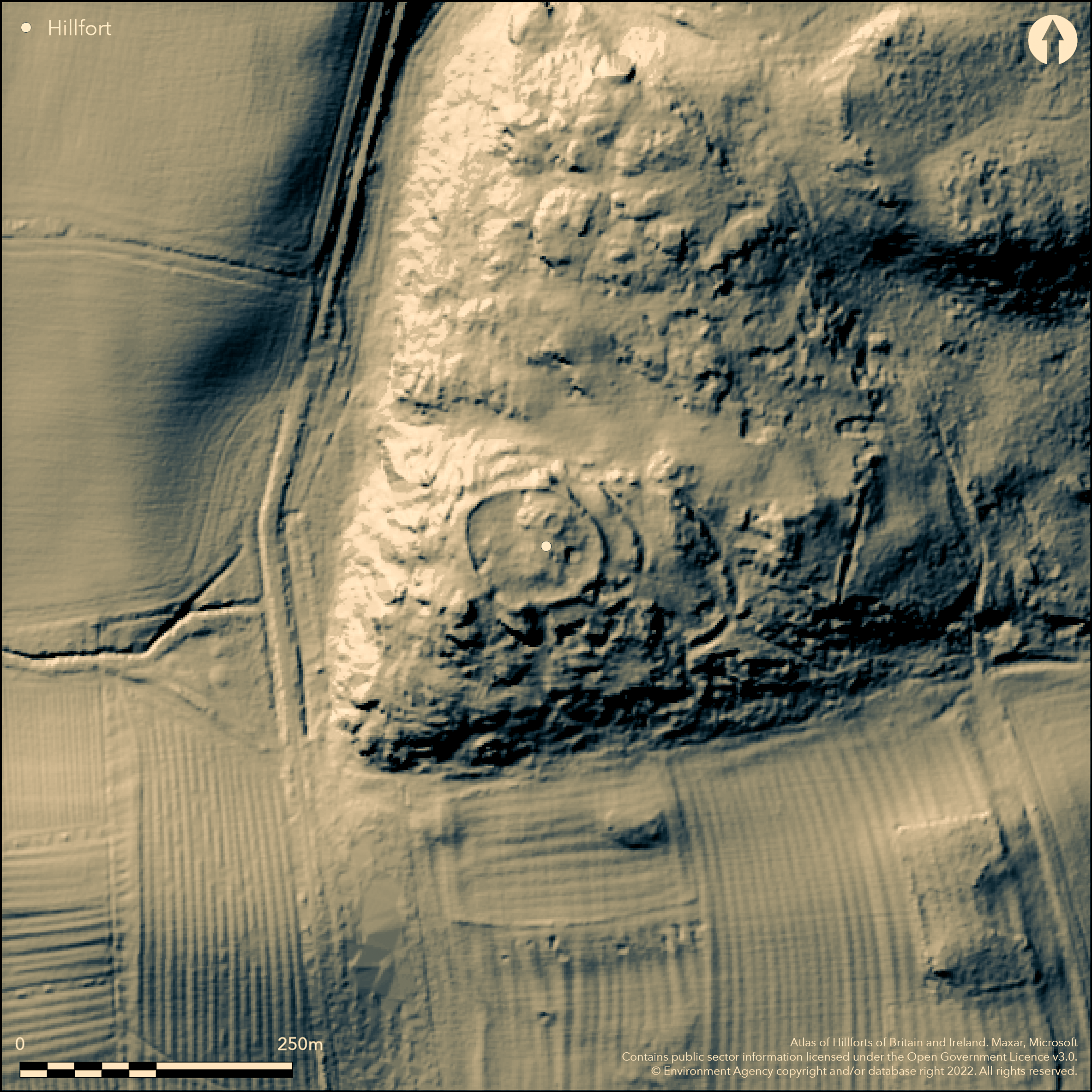
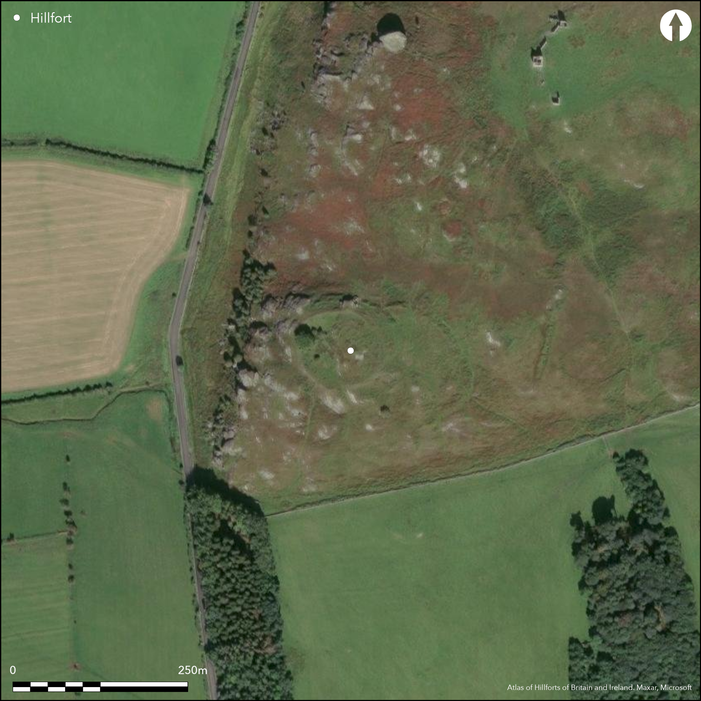
To the N of Rothley on Rothley Crags, a multivallate hillfort of 0.37ha. The enclosure is elliptical in form measuring 64m N-S by 73m E-W. It occupies a naturally prominent position at 229m OD, precipitious in the W offering extensive views in all but the NW. The inner enclosure was utilised as a sheep stell and an18th century ashlar wall has been constructed over the original ramparts. Two additional banks and ditches lie in the N and E terminating at the edge of the cliffs, with those in the E having a maximum of 23m separation. A counterscarp bank lies to the N. A break in the S where the terminal banks turn inwards is considered to be the original entrance. This is approached by a partially rock-cut holloway. It was blocked by rubble at some time in the past. A further, probably later break lies in the SE. Internally two stone-founded huts have been identified 12.7m and 11.6m in diameter. They are believed to represent secondary occupation contemporary with an annex in the E which cuts across the outer ditch and counterscarp in the N and therefore post-dates the construction of the main enclosure. The annex was constructed as a single bank and ditch 7.5m wide and 1.5m deep with an entrance in the E. The hillfort is breached by a modern track and quarries in the S, but otherwise survives in good condition. It is recorded on 1885-1900 OS mapping. Minimal investigations, undated. The levelling of a rock outcrop on the S side of the hillfort is possibly a platform for a beacon. Unpublished survey by Jobey held in the Museum of Antiquities archive (now the Great North Museum).
Citizen Science: ✗
Reliability of Data: Confirmed
Reliability of Interpretation: Confirmed
X: -215430 Y: 7398991 (EPSG: 3857)
Longitude: -1.9352362336984132 Latitude: 55.19083162310069 (EPSG:4326)
Country: England
Current County or Unitary Authority: Northumberland
Historic County: Northumberland
Current Parish/Community/Council/Townland: Rothley
None
| Extant | ✓ |
| Cropmark | ✗ |
| Likely Destroyed | ✗ |
None
| Woodland | ✗ |
| Commercial Forestry Plantation | ✗ |
| Parkland | ✗ |
| Pasture (Grazing) | ✗ |
| Arable | ✗ |
| Scrub/Bracken | ✗ |
| Bare Outcrop | ✗ |
| Heather/Moorland | ✓ |
| Heath | ✗ |
| Built-up | ✗ |
| Coastal Grassland | ✗ |
| Other | ✗ |
Multivallate hillslope fort occupying a naturally strong position on ground that slopes to the SW. Precipitous in the W offering extensive views in all but the NW.
| Contour Fort | ✗ |
| Partial Contour Fort | ✗ |
| Promontory Fort | ✗ |
| Hillslope Fort | ✓ |
| Level Terrain Fort | ✗ |
| Marsh Fort | ✗ |
| Multiple Enclosure Fort | ✗ |
| Hilltop | ✗ |
| Coastal Promontory | ✗ |
| Inland Promontory | ✗ |
| Valley Bottom | ✗ |
| Knoll/Hillock/Outcrop | ✗ |
| Ridge | ✗ |
| Cliff/Plateau-edge/Scarp | ✓ |
| Hillslope | ✓ |
| Lowland | ✗ |
| Spur | ✗ |
Dominant Topographic Feature: Summit of Rothley Hill
| North | ✗ |
| Northeast | ✗ |
| East | ✗ |
| Southeast | ✗ |
| South | ✗ |
| Southwest | ✓ |
| West | ✗ |
| Northwest | ✗ |
| Level | ✗ |
Altitude: 229.0m
N/A
Undated.
Reliability: D - None
| Pre 1200BC | ✗ |
| 1200BC - 800BC | ✗ |
| 800BC - 400BC | ✗ |
| 400BC - AD50 | ✗ |
| AD50 - AD400 | ✗ |
| AD400 - AD 800 | ✗ |
| Post AD800 | ✗ |
| Unknown | ✓ |
| Pre Hillfort: | None |
| Post Hillfort: | Stone founded huts and are annex are possibly Roman. 18th century sheep stell |
General reference in Hodgson (1827). Recorded on 1885-1900 OS mapping. Unpublished survey by G. Jobey. Field investigation in 1968
| 1st Identified Written Reference (1827): | None |
| Other (1968): | Field investigation |
| 1st Identified Map Depiction (None): | None |
| Earthwork Survey (None): | G. Jobey (Unpublished) |
Two stone-founded huts 12.7m and 11.6m in diameter.
Delf Burn lies to the W
| None | ✓ |
| Spring | ✗ |
| Stream | ✗ |
| Pool | ✗ |
| Flush | ✗ |
| Well | ✗ |
| Other | ✗ |
None
| No Known Features | ✗ |
| Round Stone Structures | ✓ |
| Rectangular Stone Structures | ✗ |
| Curvilinear Platforms | ✗ |
| Other Roundhouse Evidence | ✗ |
| Pits | ✗ |
| Quarry Hollows | ✗ |
| Other | ✗ |
None
| No Known Excavation | ✓ |
| Pits | ✗ |
| Postholes | ✗ |
| Roundhouses | ✗ |
| Rectangular Structures | ✗ |
| Roads/Tracks | ✗ |
| Quarry Hollows | ✗ |
| Other | ✗ |
| Nothing Found | ✗ |
None
| No Known Geophysics | ✓ |
| Pits | ✗ |
| Roundhouses | ✗ |
| Rectangular Structures | ✗ |
| Roads/Tracks | ✗ |
| Quarry Hollows | ✗ |
| Other | ✗ |
| Nothing Found | ✗ |
None
| No Known Finds | ✓ |
| Pottery | ✗ |
| Metal | ✗ |
| Metalworking | ✗ |
| Human Bones | ✗ |
| Animal Bones | ✗ |
| Lithics | ✗ |
| Environmental | ✗ |
| Other | ✗ |
None
| APs Not Checked | ✓ |
| None | ✗ |
| Roundhouses | ✗ |
| Rectangular Structures | ✗ |
| Pits | ✗ |
| Postholes | ✗ |
| Roads/Tracks | ✗ |
| Other | ✗ |
A break in the S where the terminal banks turn inwards is considered to be the original entrance. It was later blocked by rubble. A second break lies in the SE which is modern.
| 2: | None |
| 2: | None |
Guard Chambers: ✗
Chevaux de Frise: ✗
| 1. In-turned (South): | None |
| 1. Hollow Way (South): | None |
| 1. Blocked (South): | None |
Elliptical in form measuring 64m N-S by 73m E-W. The inner enclosure was utilised as a sheep stell and an 18th century ashlar wall overlies the original ramparts. Two further banks and ditches lie in the N and E terminating at the edge of the cliffs, with those in the E having a maximum of 23m separation. A counterscarp lies to the N
| Area 1: | 0.37ha. |
| Total: | 0.37ha. |
Total Footprint Area: Noneha.
None
| ✗ | Area estimated from dimensions |
| ✓ | None |
| NE Quadrant: | 3 |
| SE Quadrant: | 1 |
| SW Quadrant: | 1 |
| NW Quadrant: | 1 |
| Total: | 3 |
| Partial Univallate | ✓ |
| Univallate | ✗ |
| Partial Bivallate | ✗ |
| Bivallate | ✗ |
| Partial Multivallate | ✓ |
| Multivallate | ✗ |
| Unknown | ✗ |
| Partial Univallate | ✗ |
| Univallate | ✗ |
| Partial Bivallate | ✗ |
| Bivallate | ✗ |
| Partial Multivallate | ✗ |
| Multivallate | ✗ |
None
| None | ✗ |
| Earthen Bank | ✗ |
| Stone Wall | ✓ |
| Rubble | ✓ |
| Wall-walk | ✗ |
| Evidence of Timber | ✗ |
| Vitrification | ✗ |
| Other Burning | ✗ |
| Palisade | ✗ |
| Counter Scarp Bank | ✓ |
| Berm | ✗ |
| Unfinished | ✗ |
| Other | ✗ |
None
| None | ✗ |
| Earthen Bank | ✗ |
| Stone Wall | ✗ |
| Murus Duplex | ✗ |
| Timber-framed | ✗ |
| Timber-laced | ✗ |
| Vitrification | ✗ |
| Other Burning | ✗ |
| Palisade | ✗ |
| Counter Scarp Bank | ✗ |
| Berm | ✗ |
| Unfinished | ✗ |
| No Known Excavation | ✓ |
| Other | ✗ |
| ✗ | None |
| ✓ | None |
Number of Ditches: 2
| ✓ | To the E of the main enclosure. The annex cuts across the outer ditch and counterscarp of the main enclosure in the N and therefore post-dates its construction. Single bank and ditch 7.5m wide and 1.5m deep with an entrance in the E. |
Hodgson, J C, 1827. History of Northumberland, part 2, vol 1. (306) (2)
Jobey, G. 1965. Hillforts and Settlements in Northumberland. Archaeol Aeliana (4th Series) 43
Atlas of Hillforts:
Wikidata:
This work is licensed under CC BY-SA 4.0![]()
![]()
![]() and should be cited as:
and should be cited as:
Lock, Gary and Ralston, Ian. 2024. Atlas of Hillforts of Britain and Ireland. Available at: https://hillforts.arch.ox.ac.uk
Document Version 1.1