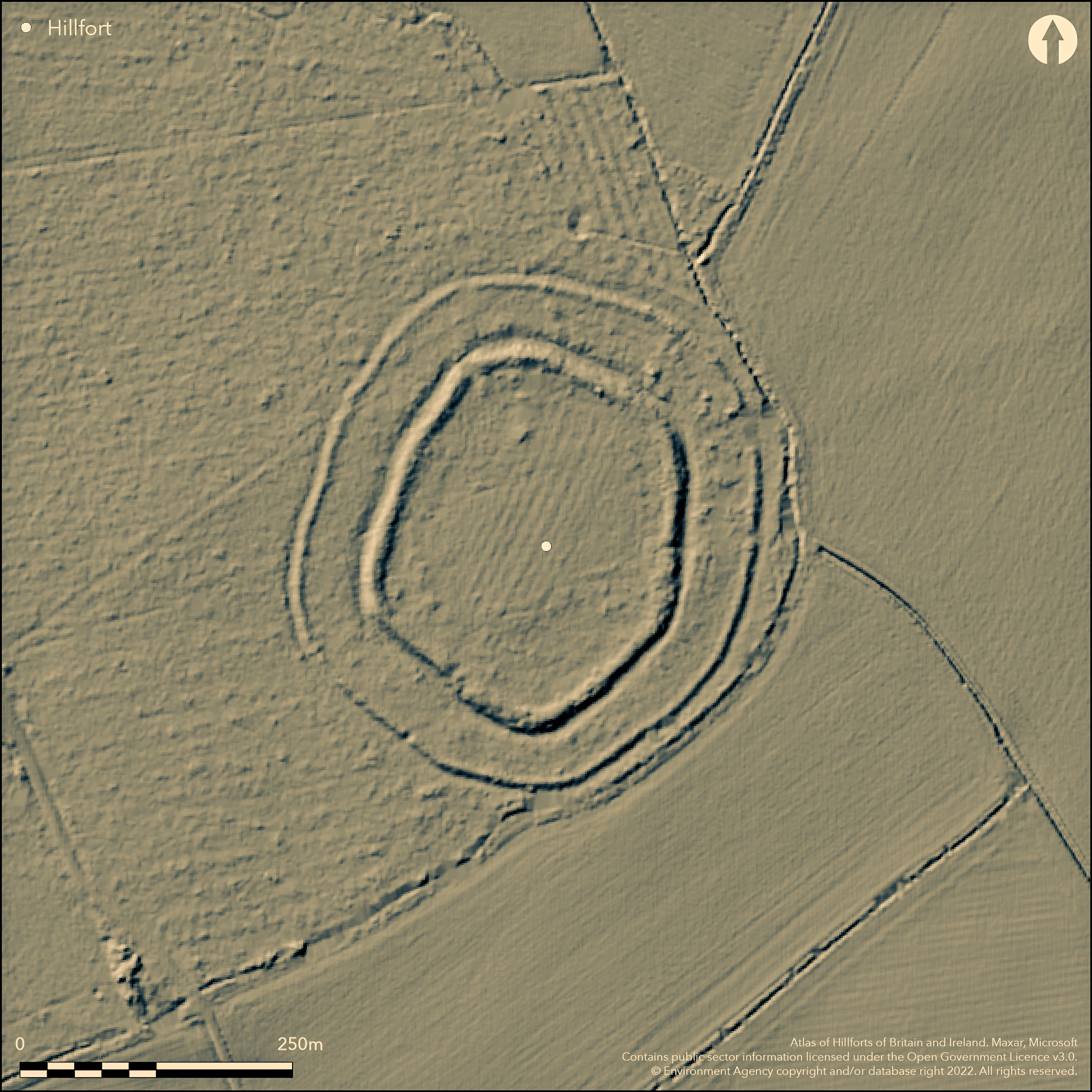
LiDAR 1m DTM Hillshade
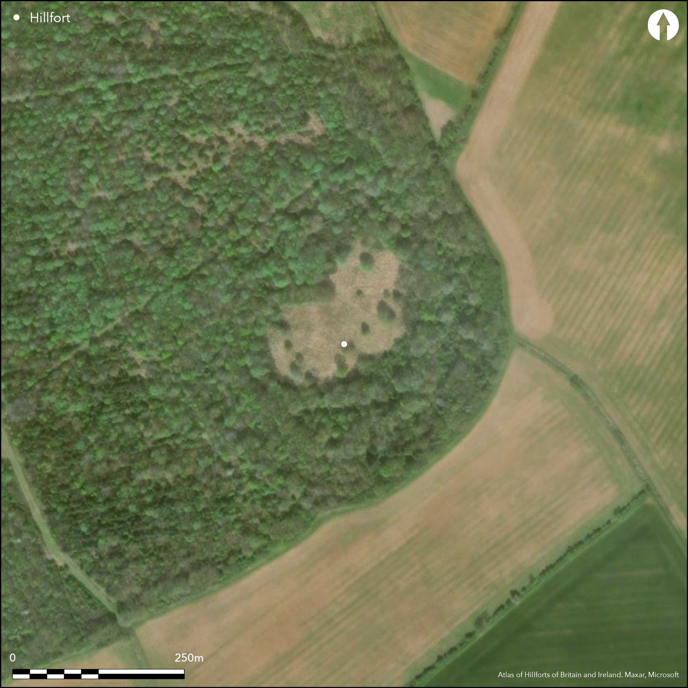
Satellite Imagery
LiDAR 1m DTM Hillshade
Satellite Imagery
Scroll left/right to view further images.
HER: Lincolnshire 30057 (None)
NMR: TF 01 NW 4 (348223)
SM: 1003613
NGR: TF 04004 15601
X: 504004 Y: 315601 (OSGB36)
A bivallate hillfort lying at 53m OD, 1.7km to the SE of Careby. Oval in form measuring 331m NE-SW by 271m transversely enclosing 5ha. It comprises two banks, and two ditches. The inner bank stands at approximately 0.9m high and 1.5m above the bottom of the ditch. The outer bank, which is separated from the inner bank by approximately 40m, is slighter at approximately 0.3m. A simple gap entrance lies at the northern end of the enclosure across the inner ditch with further breaks in the SW and E, although no associated causeway has been recorded and they are probably not original. An inspection in 1971 showed the enclosing works survived in good condition. Historic OS mapping from 1885 shows it lying entirely within Careby Wood. Satellite imagery shows the wood has been cleared although trees remain on the enclosing bank with some regeneration of the woodland in the surrounding fields. Some damage has occurred to the ramparts through animal burrowing. Recorded on 1885-1900 OS mapping. It remains undated but is considered Iron Age.
Citizen Science: ✗
Reliability of Data: Confirmed
Reliability of Interpretation: Confirmed
X: -51355 Y: 6932849 (EPSG: 3857)
Longitude: -0.46132709675586053 Latitude: 52.72803442775712 (EPSG:4326)
Country: England; None
Current County or Unitary Authority: Lincolnshire
Historic County: Lincolnshire
Current Parish/Community/Council/Townland: Careby Aunby and Holywell; Witham on the Hill
None
| Extant | ✓ |
| Cropmark | ✗ |
| Likely Destroyed | ✗ |
Woodland appears to be regenerating
| Woodland | ✗ |
| Commercial Forestry Plantation | ✓ |
| Parkland | ✗ |
| Pasture (Grazing) | ✗ |
| Arable | ✗ |
| Scrub/Bracken | ✗ |
| Bare Outcrop | ✗ |
| Heather/Moorland | ✗ |
| Heath | ✗ |
| Built-up | ✗ |
| Coastal Grassland | ✗ |
| Other | ✗ |
On level ground at 53m OD on a south-easterly facing spur
| Contour Fort | ✗ |
| Partial Contour Fort | ✗ |
| Promontory Fort | ✗ |
| Hillslope Fort | ✗ |
| Level Terrain Fort | ✓ |
| Marsh Fort | ✗ |
| Multiple Enclosure Fort | ✗ |
| Hilltop | ✓ |
| Coastal Promontory | ✗ |
| Inland Promontory | ✗ |
| Valley Bottom | ✗ |
| Knoll/Hillock/Outcrop | ✗ |
| Ridge | ✗ |
| Cliff/Plateau-edge/Scarp | ✗ |
| Hillslope | ✗ |
| Lowland | ✓ |
| Spur | ✓ |
Dominant Topographic Feature: Level ground on a south-easterly facing spur
| North | ✗ |
| Northeast | ✗ |
| East | ✗ |
| Southeast | ✓ |
| South | ✗ |
| Southwest | ✗ |
| West | ✗ |
| Northwest | ✗ |
| Level | ✗ |
Altitude: 53.0m
The parish boundaries of Witham on the Hill and Careby Aunby and Holywell lie to the E and the parish boundaries of Careby Aunby and Holywell and Carlby a short distance to the S
Boundary Type: Parish/Townland
Undated but probably Iron Age based on morphology
Reliability: D - None
| Pre 1200BC | ✗ |
| 1200BC - 800BC | ✗ |
| 800BC - 400BC | ✓ |
| 400BC - AD50 | ✓ |
| AD50 - AD400 | ✗ |
| AD400 - AD 800 | ✗ |
| Post AD800 | ✗ |
| Unknown | ✗ |
| Pre Hillfort: | None |
| Post Hillfort: | None |
| Morphology/Earthwork/Typology: | None |
Recorded in 1885-1900 OS mapping. Inspection by Archaeological Project Services in 2001. Field investigations in 1965 and 1977. Scheduled
| Other (1965): | Field investigation |
| Other (1977): | Field investigation |
| Other (2001): | None |
| 1st Identified Map Depiction (None): | None |
| Other (None): | Scheduled |
No internal features recorded
None
| None | ✓ |
| Spring | ✗ |
| Stream | ✗ |
| Pool | ✗ |
| Flush | ✗ |
| Well | ✗ |
| Other | ✗ |
None
| No Known Features | ✓ |
| Round Stone Structures | ✗ |
| Rectangular Stone Structures | ✗ |
| Curvilinear Platforms | ✗ |
| Other Roundhouse Evidence | ✗ |
| Pits | ✗ |
| Quarry Hollows | ✗ |
| Other | ✗ |
None
| No Known Excavation | ✓ |
| Pits | ✗ |
| Postholes | ✗ |
| Roundhouses | ✗ |
| Rectangular Structures | ✗ |
| Roads/Tracks | ✗ |
| Quarry Hollows | ✗ |
| Other | ✗ |
| Nothing Found | ✗ |
None
| No Known Geophysics | ✓ |
| Pits | ✗ |
| Roundhouses | ✗ |
| Rectangular Structures | ✗ |
| Roads/Tracks | ✗ |
| Quarry Hollows | ✗ |
| Other | ✗ |
| Nothing Found | ✗ |
None
| No Known Finds | ✓ |
| Pottery | ✗ |
| Metal | ✗ |
| Metalworking | ✗ |
| Human Bones | ✗ |
| Animal Bones | ✗ |
| Lithics | ✗ |
| Environmental | ✗ |
| Other | ✗ |
None
| APs Not Checked | ✓ |
| None | ✗ |
| Roundhouses | ✗ |
| Rectangular Structures | ✗ |
| Pits | ✗ |
| Postholes | ✗ |
| Roads/Tracks | ✗ |
| Other | ✗ |
A simple gap entrance lies at the northern end of the enclosure across the inner ditch, with further breaks in the SW and E, although no associated causeway has been recorded and they are probably not original
| 3: | At least three |
| 2: | None |
Guard Chambers: ✗
Chevaux de Frise: ✗
| 1. Simple Gap (North): | Inner rampart |
Oval in form measuring 331m NE-SW by 271m transversely enclosing 5ha. It comprises two banks, and two ditches. The inner bank stands at approximately 0.9m high and 1.5m above the bottom of the ditch, the outer bank which is separated from the inner bank by approximately 40m is slighter at approximately 0.3m.
| Area 1: | 5.0ha. |
| Total: | 5.0ha. |
Total Footprint Area: Noneha.
None
| ✗ | None |
| ✓ | None |
| NE Quadrant: | 2 |
| SE Quadrant: | 2 |
| SW Quadrant: | 2 |
| NW Quadrant: | 2 |
| Total: | 2 |
| Partial Univallate | ✗ |
| Univallate | ✗ |
| Partial Bivallate | ✗ |
| Bivallate | ✓ |
| Partial Multivallate | ✗ |
| Multivallate | ✗ |
| Unknown | ✗ |
| Partial Univallate | ✗ |
| Univallate | ✗ |
| Partial Bivallate | ✗ |
| Bivallate | ✗ |
| Partial Multivallate | ✗ |
| Multivallate | ✗ |
None
| None | ✗ |
| Earthen Bank | ✓ |
| Stone Wall | ✗ |
| Rubble | ✗ |
| Wall-walk | ✗ |
| Evidence of Timber | ✗ |
| Vitrification | ✗ |
| Other Burning | ✗ |
| Palisade | ✗ |
| Counter Scarp Bank | ✗ |
| Berm | ✗ |
| Unfinished | ✗ |
| Other | ✗ |
None
| None | ✗ |
| Earthen Bank | ✗ |
| Stone Wall | ✗ |
| Murus Duplex | ✗ |
| Timber-framed | ✗ |
| Timber-laced | ✗ |
| Vitrification | ✗ |
| Other Burning | ✗ |
| Palisade | ✗ |
| Counter Scarp Bank | ✗ |
| Berm | ✗ |
| Unfinished | ✗ |
| No Known Excavation | ✓ |
| Other | ✗ |
| ✗ | None |
| ✓ | None |
Number of Ditches: 2
| ✗ | None |
Forest Enterprise Woodlands in Lincolnshire. 2001. Archaeological Project Services, 2001, Careby Wood. (Intervention Report). Unpublished
Aguire M, 1995. Careby Camp in its Local Context. Unpublished.
Atlas of Hillforts:
Wikidata:
This work is licensed under CC BY-SA 4.0

 and should be cited as:
Lock, Gary and Ralston, Ian. 2024. Atlas of Hillforts of Britain and Ireland. Available at: https://hillforts.arch.ox.ac.uk
Document Version 1.1