LiDAR 1m DTM Hillshade
Satellite Imagery
LiDAR 1m DTM Hillshade
Satellite Imagery
Scroll left/right to view further images.
HER: Lancashire MLA224 (None)
NMR: SD 83 NE 7 (45247)
SM: 1007404
NGR: SD 88486 38386
X: 388486 Y: 438386 (OSGB36)
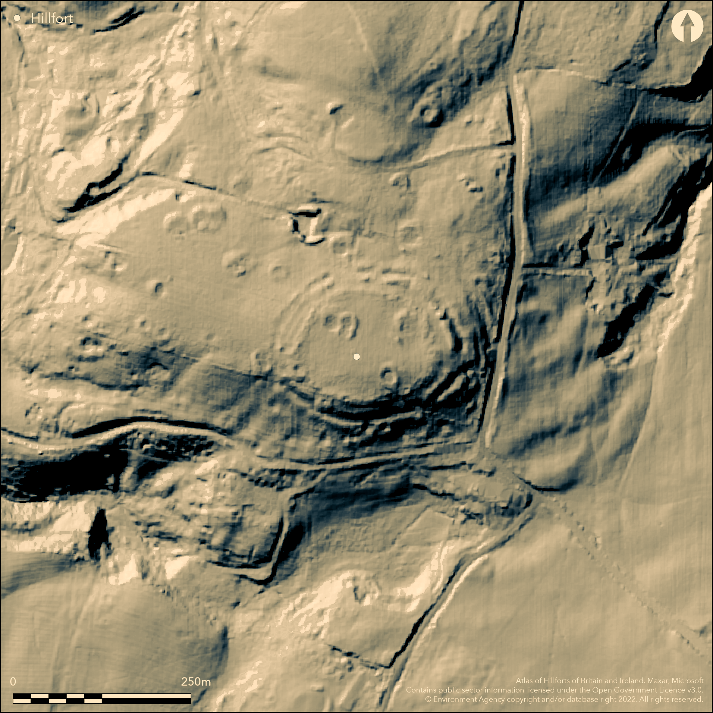
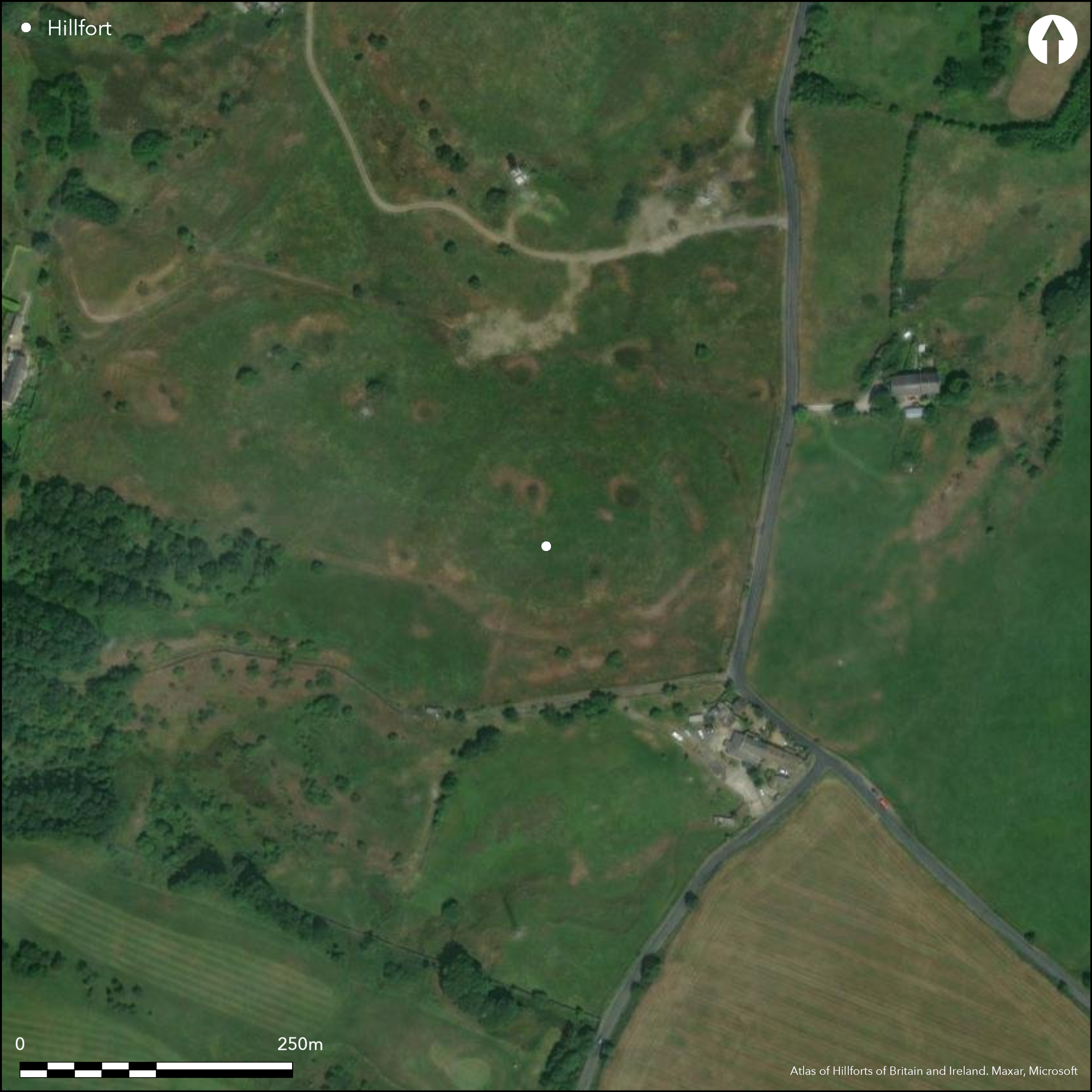
Lying in open land 660m to the E of the outskirts of Nelson, a small, oval multivallate hillfort of 0.8ha. It occupies an area of high ground overlooking the Calder Valley. Three concentric rubble ramparts follow the contours around a level plateau measuring 115m by 76m. In the N there is a single complete rampart with two further interrupted stretches of rampart and ditch interspersed with areas of undisturbed ground. Forde-Johnson (1976) concluded that this was evidence for two phases of construction, the first being a single bank without a ditch, with a bank and ditch between and traces of a counterscarp. Later a further outer bank and ditch which was never completed. The area of undisturbed ground was confirmed through excavation (Coombs 1982). Excavation of the central rampart revealed continuous bedding trenches to the front and rear 1.8m apart, in which were set post holes up to 0.9cm deep and approximately 1.8m apart. The ramparts now survive up to 1.5m high, each with external rock-cut ditches 1.5m deep and 0.9m wide and a counterscarp with an overall width to the defences of 46m. Internally there is level plateau but no features are recorded. Large quantities of stone removed from the inner rampart in the 19th century was said to be heavily vitrified. Damage to the ramparts has also occurred through open cast mining and bellpits. Uncalibrated radiocarbon dates of 510+/-70bc and 510+/-60bc were obtained from the outer and inner ramparts. The site is shown on 1848 1:10,560 OS mapping.
Citizen Science: ✗
Reliability of Data: Confirmed
Reliability of Interpretation: Confirmed
X: -242284 Y: 7140212 (EPSG: 3857)
Longitude: -2.176474688964704 Latitude: 53.84159002693213 (EPSG:4326)
Country: England; None
Current County or Unitary Authority: Lancashire
Historic County: Lancashire
Current Parish/Community/Council/Townland: Nelson; Colne
Some damage has occurred to the ramparts through open-cast mineral extraction and bell-pits.
| Extant | ✓ |
| Cropmark | ✗ |
| Likely Destroyed | ✗ |
None
| Woodland | ✗ |
| Commercial Forestry Plantation | ✗ |
| Parkland | ✗ |
| Pasture (Grazing) | ✓ |
| Arable | ✗ |
| Scrub/Bracken | ✗ |
| Bare Outcrop | ✗ |
| Heather/Moorland | ✗ |
| Heath | ✗ |
| Built-up | ✗ |
| Coastal Grassland | ✗ |
| Other | ✗ |
A contour fort occupying high ground at 274m OD overlooking the Calder Valley.
| Contour Fort | ✓ |
| Partial Contour Fort | ✗ |
| Promontory Fort | ✗ |
| Hillslope Fort | ✗ |
| Level Terrain Fort | ✗ |
| Marsh Fort | ✗ |
| Multiple Enclosure Fort | ✗ |
| Hilltop | ✓ |
| Coastal Promontory | ✗ |
| Inland Promontory | ✗ |
| Valley Bottom | ✗ |
| Knoll/Hillock/Outcrop | ✗ |
| Ridge | ✗ |
| Cliff/Plateau-edge/Scarp | ✗ |
| Hillslope | ✗ |
| Lowland | ✗ |
| Spur | ✗ |
Dominant Topographic Feature: Area of high ground overlooking the Calder Valley.
| North | ✗ |
| Northeast | ✗ |
| East | ✗ |
| Southeast | ✗ |
| South | ✗ |
| Southwest | ✗ |
| West | ✗ |
| Northwest | ✗ |
| Level | ✓ |
Altitude: 274.0m
The northern extent lies on the parish boundaries of Nelson and Colne
Boundary Type: Parish/Townland
Uncalibrated radiocarbon dates of 510+/-70bc and 510+/-60bc obtained from the outer and inner ramparts
Reliability: B - Medium
| Pre 1200BC | ✗ |
| 1200BC - 800BC | ✗ |
| 800BC - 400BC | ✓ |
| 400BC - AD50 | ✗ |
| AD50 - AD400 | ✗ |
| AD400 - AD 800 | ✗ |
| Post AD800 | ✗ |
| Unknown | ✗ |
| Pre Hillfort: | None |
| Post Hillfort: | None |
| C14: | None |
Described as Castell Clif in 1515, Castyclyff 1533 (Ekwall 1922) meaning 'castle on a cliff', Recorded on 1848 1:10,560 OS mapping. Plan by Ford-Johnston 1962 and Coombs 1971. Limited excavations in 1958-60 (unpublished, reported in Coombs (1982). Excavated in 1971 (Coombs 1982). Scheduled.
| 1st Identified Written Reference (1515): | None |
| 1st Identified Map Depiction (1848): | None |
| Other (1925): | Scheduled |
| Earthwork Survey (1962): | None |
| Excavation (1971): | Coombs (1982) |
| Earthwork Survey (1971): | None |
| Excavation (None): | None |
No internal features are recorded
None
| None | ✓ |
| Spring | ✗ |
| Stream | ✗ |
| Pool | ✗ |
| Flush | ✗ |
| Well | ✗ |
| Other | ✗ |
None
| No Known Features | ✓ |
| Round Stone Structures | ✗ |
| Rectangular Stone Structures | ✗ |
| Curvilinear Platforms | ✗ |
| Other Roundhouse Evidence | ✗ |
| Pits | ✗ |
| Quarry Hollows | ✗ |
| Other | ✗ |
None
| No Known Excavation | ✗ |
| Pits | ✗ |
| Postholes | ✗ |
| Roundhouses | ✗ |
| Rectangular Structures | ✗ |
| Roads/Tracks | ✗ |
| Quarry Hollows | ✗ |
| Other | ✗ |
| Nothing Found | ✓ |
None
| No Known Geophysics | ✓ |
| Pits | ✗ |
| Roundhouses | ✗ |
| Rectangular Structures | ✗ |
| Roads/Tracks | ✗ |
| Quarry Hollows | ✗ |
| Other | ✗ |
| Nothing Found | ✗ |
None
| No Known Finds | ✓ |
| Pottery | ✗ |
| Metal | ✗ |
| Metalworking | ✗ |
| Human Bones | ✗ |
| Animal Bones | ✗ |
| Lithics | ✗ |
| Environmental | ✗ |
| Other | ✗ |
None
| APs Not Checked | ✓ |
| None | ✗ |
| Roundhouses | ✗ |
| Rectangular Structures | ✗ |
| Pits | ✗ |
| Postholes | ✗ |
| Roads/Tracks | ✗ |
| Other | ✗ |
Numerous breaks around the ramparts. The location of entrances is not recorded although Coombs (1982) observed evidence for a free standing palisade or possibly a chevaux de Frise outside the ditch
| None: | None |
| 2: | None |
Guard Chambers: ✗
Chevaux de Frise: ✓
An oval, multivallate and possibly multiphase hillfort. Three concentric rubble ramparts follow the contours around a level plateau measuring 115m by 76m. In the N there is a single complete rampart with two further interrupted stretches of rampart and ditch interspersed with areas of undisturbed ground. Excavation of the central rampart revealed continuous bedding trenches to the front and rear 1.8m apart, in which were set post holes up to 0.9cm deep and about 1.8m apart. The ramparts now survive up to 1.5m high, each with external rock-cut ditches 1.5m deep and 0.9m wide and a counterscarp with an overall width to the defences of 46m. Large quantities of stone removed from the inner rampart in the 19th century was said to be heavily vitrified.
| Area 1: | 0.8ha. |
| Total: | 0.8ha. |
Total Footprint Area: Noneha.
None
| ✓ | None |
| ✓ | Present, but interrupted in the N where they comprise a single rampart and ditch with some traces of a triple rampart and ditch. Possibly unfinished |
| NE Quadrant: | 1 |
| SE Quadrant: | 3 |
| SW Quadrant: | 3 |
| NW Quadrant: | 1 |
| Total: | 3 |
| Partial Univallate | ✓ |
| Univallate | ✗ |
| Partial Bivallate | ✗ |
| Bivallate | ✗ |
| Partial Multivallate | ✓ |
| Multivallate | ✗ |
| Unknown | ✗ |
| Partial Univallate | ✗ |
| Univallate | ✗ |
| Partial Bivallate | ✗ |
| Bivallate | ✓ |
| Partial Multivallate | ✓ |
| Multivallate | ✗ |
None
| None | ✗ |
| Earthen Bank | ✗ |
| Stone Wall | ✗ |
| Rubble | ✓ |
| Wall-walk | ✗ |
| Evidence of Timber | ✗ |
| Vitrification | ✗ |
| Other Burning | ✗ |
| Palisade | ✗ |
| Counter Scarp Bank | ✓ |
| Berm | ✗ |
| Unfinished | ✓ |
| Other | ✗ |
Inner rampart stone revetted and timber-laced
| None | ✗ |
| Earthen Bank | ✗ |
| Stone Wall | ✓ |
| Murus Duplex | ✗ |
| Timber-framed | ✗ |
| Timber-laced | ✓ |
| Vitrification | ✓ |
| Other Burning | ✗ |
| Palisade | ✗ |
| Counter Scarp Bank | ✗ |
| Berm | ✗ |
| Unfinished | ✓ |
| No Known Excavation | ✗ |
| Other | ✗ |
| ✗ | None |
| ✓ | None |
Number of Ditches: 3
| ✗ | None |
Coombs, D. G. 1982. Excavations at the hillfort of Castercliff, Nelson, Lancashire, 1970-71. Trans Lancashire Cheshire Antiq Soc 81, 1982 111-30
Ekwall, E. 1922. The Placenames of Lancashire. Manchester University Press.
Forde-Johnson, J. 1962. The Hillforts of Lancashire and Cheshire. Trans Lancashire Cheshire Antiq Soc
Forde-Johnson, J. 1976. Hillforts of the Iron Age in England & Wales, 106, 122.
Whittaker, T.D. 1801. History of Whalley, 26-7
Atlas of Hillforts:
Wikidata:
This work is licensed under CC BY-SA 4.0![]()
![]()
![]() and should be cited as:
and should be cited as:
Lock, Gary and Ralston, Ian. 2024. Atlas of Hillforts of Britain and Ireland. Available at: https://hillforts.arch.ox.ac.uk
Document Version 1.1