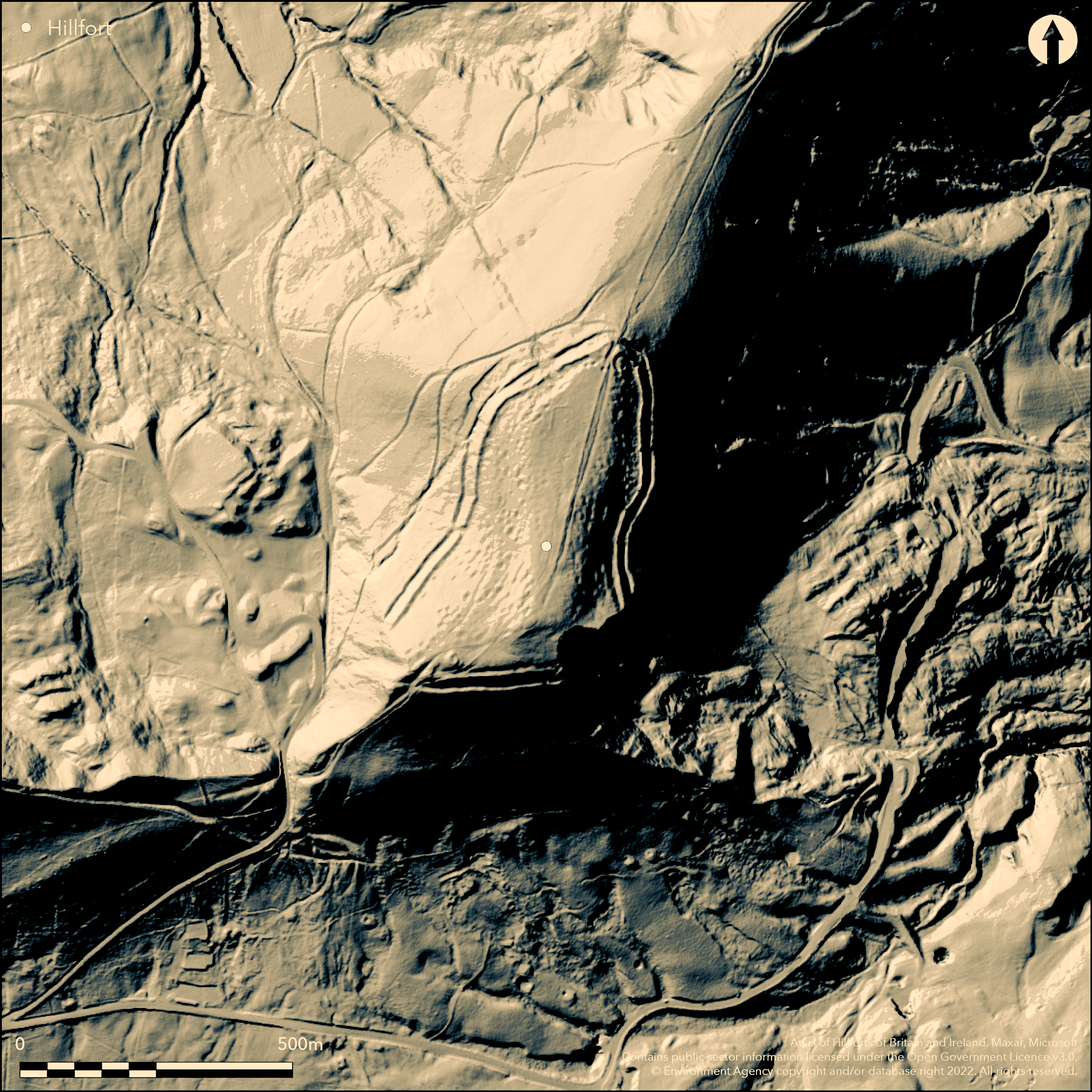
LiDAR 1m DTM Hillshade
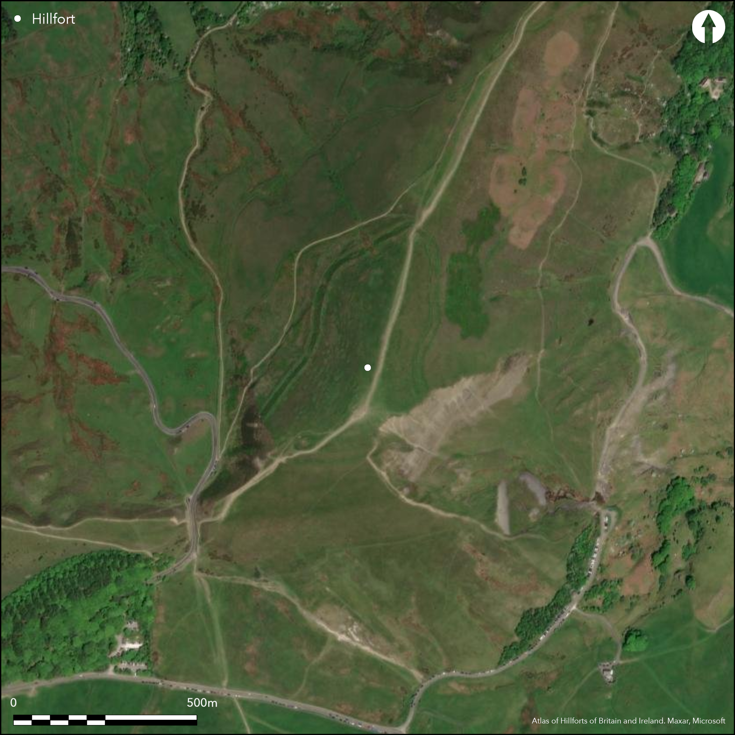
Satellite Imagery
LiDAR 1m DTM Hillshade
Satellite Imagery
Scroll left/right to view further images.
HER: Derbyshire 3319 (None)
NMR: SK 18 SW 1 (309590)
SM: 1011206
NGR: SK 12784 83696
X: 412784 Y: 383696 (OSGB36)
Lying at the head of the Hope Valley, 2km to the NW of Castleton, a univallate hillfort of approximately 6ha. It comprises a bank, ditch and counterscarp bank which follow the 480m contour, from which the interior rises to 517m along the central ridge. Its location commands views in all directions and it is surrounded by almost precipitous slopes except in the N where it is connected to the ridge of Lose Hill. Ramparts are absent in the SE and SW in the area of the landslips, at least one of which is is over 4000 years old (Waltham and Dixon 2000), pre-dating the construction of the hillfort and suggesting they were never present in these areas. Excavation and radiocarbon dating has shown the hillfort had more than one phase of construction with its origins possibly in the late Bronze Age with a possible palisade prior to the bank and ditch (Coombs and Thompson 1979). A trench placed across the width of the earthworks to the S of the entrance in the NW, which extended from the inside of the rampart to the outside of the counterscarp bank showed that in this region, the rampart had been built on a level platform cut into the slope. It was constructed as a box rampart using layers of soil, clay and stones, and rubble. A slight retaining wall had been constructed behind the rampart, which was further strengthened by a dump of material. At the front of the rampart was a stronger wall constructed with larger stones. The existence of a turf line between the layers showed that the rampart had been heightened at least once. The rampart survived up to 3m high above the old land surface and was 5.4m wide and the ditch 2.4m wide at the top with a U-shaped profile and between 1.6-1.8m deep, which with the gradient of the hillside gives a height of 9m from the bottom of the ditch to the top of the rampart. The counterscarp, which was approximately 2m wide and 1m high was composed of material dumped directly onto the old land surface and covered with rubble. A second trench further to the N, placed across the rampart on much steeper ground showed that although of similar construction, the ground surface had not been levelled and there was no evidence for subsequent heightening of the rampart. A circular posthole was observed in front of the revetment wall. In-turned entrances lie in the NW and SW on the easiest points of access. Internally, hut platforms are visible on both the W and E-facing slopes and these and other features were further elucidated through geophysics and excavation. The excavations showed the house platforms had been created by terracing into the side of the hill. Hearths, postholes, stakeholes, storage pits and gullies were all uncovered along with four whetstones, fragments of shale bracelets and a large assemblage of late Bronze Age-early Iron Age locally produced pottery. A fragment from a socketed axe found within one of the huts was dated typologically to c.600 BC. A later reappraisal found it is made of lead rather than bronze - a rare find in Britain and possibly the earliest indication of exploitation of the resources of lead in the nearby White Peak (Guilbert 1996). Two radiocarbon dates obtained from charcoal from the house platforms gave possible dates of later Bronze Age. A Neolithic polished stone axe, also recovered during the excavations might indicate an earlier use of the site. Two bowl barrows lie in the S of the hillfort, at least one of which has been excavated (Bevan 2001). Mam Tor is formed from sandstones with underlying shales and there is an active landslip on its SE and SW sides almost to the summit. Further erosion is being caused by visitors. The site is recorded on 1880 1:2,500 OS mapping. Scheduled
Citizen Science: ✗
Reliability of Data: Confirmed
Reliability of Interpretation: Confirmed
X: -201424 Y: 7048001 (EPSG: 3857)
Longitude: -1.8094221143542026 Latitude: 53.34998948190821 (EPSG:4326)
Country: England; None
Current County or Unitary Authority: Derbyshire
Historic County: Derbyshire
Current Parish/Community/Council/Townland: Castleton; Edale
Active landslips in the SE and SW which have possibly removed the ramparts in this area. Interior and N entrance damaged by visitor erosion but surviving in good condition elsewhere.
| Extant | ✓ |
| Cropmark | ✗ |
| Likely Destroyed | ✓ |
Lies within the Peak District National Park
| Woodland | ✗ |
| Commercial Forestry Plantation | ✗ |
| Parkland | ✗ |
| Pasture (Grazing) | ✓ |
| Arable | ✗ |
| Scrub/Bracken | ✗ |
| Bare Outcrop | ✗ |
| Heather/Moorland | ✗ |
| Heath | ✗ |
| Built-up | ✗ |
| Coastal Grassland | ✗ |
| Other | ✗ |
A contour fort lying on a ridge at 517m OD. The Tor is composed of sandstone and shale and active landslips have resulted in small hills forming around the lower slopes, with Mam Tor meaning 'mother hill'. It is also known as 'shivering mountain.
| Contour Fort | ✓ |
| Partial Contour Fort | ✗ |
| Promontory Fort | ✗ |
| Hillslope Fort | ✗ |
| Level Terrain Fort | ✗ |
| Marsh Fort | ✗ |
| Multiple Enclosure Fort | ✗ |
| Hilltop | ✗ |
| Coastal Promontory | ✗ |
| Inland Promontory | ✗ |
| Valley Bottom | ✗ |
| Knoll/Hillock/Outcrop | ✗ |
| Ridge | ✓ |
| Cliff/Plateau-edge/Scarp | ✗ |
| Hillslope | ✗ |
| Lowland | ✗ |
| Spur | ✗ |
Dominant Topographic Feature: Hogback ridge
| North | ✗ |
| Northeast | ✓ |
| East | ✗ |
| Southeast | ✓ |
| South | ✗ |
| Southwest | ✓ |
| West | ✗ |
| Northwest | ✓ |
| Level | ✗ |
Altitude: 517.0m
Parish boundary of Edale and Castleton runs centrally through the hillfort
Boundary Type: Parish/Townland
Two radiocarbon dates of 1180 +/- 132bc and 1130+/- 115bc were obtained. However they were from composite collections of charcoal fragments and the samples were not securely sealed. The possibility of contamination by charcoal of different dates could not be ruled out.
Reliability: B - Medium
| Pre 1200BC | ✗ |
| 1200BC - 800BC | ✓ |
| 800BC - 400BC | ✓ |
| 400BC - AD50 | ✓ |
| AD50 - AD400 | ✗ |
| AD400 - AD 800 | ✗ |
| Post AD800 | ✗ |
| Unknown | ✗ |
| Pre Hillfort: | None |
| Post Hillfort: | None |
| Artefactual: | None |
| C14: | None |
| Morphology/Earthwork/Typology: | None |
In Aubrey's Monumenta Britannica (1665-1693). Description and plan (Bray 1783). Recorded on 1880 1:2,500 OS mapping. Ordnance Survey Field Report 1965. Excavation and geophysical survey by Manchester University between 1965-69 (Coombs and Thompson 1979). Excavation and survey work in 1993-95 to accompany a programme of erosion repairs; excavation of one of the two summit barrows showed that its lower portion survived intact beneath stone capping. Excavation of a small trench was also undertaken around a findspot where a sherd of Iron Age pottery had been found. (Unpublished report and Guilbert & Vince 1996). Archaeological watching brief of repair groundworks in 1998 which included the recording of the base of a drystone wall. A further stretch had been recorded in 1993. The banks are presumed to represent robbed cross-ridge walls that were possibly dismantled for the construction of a ridge-top wall in existence in 1783 (Guilbert 2001). Included in a National Trust management survey in 2001 (Bevan 2001). In November 2013, the National Trust commissioned an archaeological watching brief during a programme of footpath improvements at the north-eastern gateway. No artefacts were encountered. A cluster of gritstone blocks uncovered at the gateway, 150 to 200mm below the ground surface were considered to be anthropgenic. Not fully-investigated (Mora-Ottomano 2014). Scheduled.
| Other (1936): | Scheduled |
| Geophysical Survey (1965): | None |
| Other (1965): | Field investigation |
| Other (1979): | Visit by Hillfort Study Group |
| Other (1998): | Watching Brief |
| Other (1999): | Visited by Hillfort Study Group |
| Other (2001): | Watching Brief |
| Other (2013): | Watching brief |
| 1st Identified Written Reference (None): | None |
| 1st Identified Map Depiction (None): | None |
| Excavation (None): | None |
| Excavation (None): | None |
Hut platforms, one containing an internal hearth, storage pits, postholes and gulleys. Large quantities of pottery including jars both coarse and fine wares. Polished stone axe; socketed axe fragment, of the Sompting type (post 650 BC). four whetstones, shale bracelet fragments. Charcoal used for radiocarbon dating.
A spring is shown on OS mapping originating near the rampart in the NW
| None | ✗ |
| Spring | ✓ |
| Stream | ✗ |
| Pool | ✗ |
| Flush | ✗ |
| Well | ✗ |
| Other | ✗ |
None
| No Known Features | ✗ |
| Round Stone Structures | ✗ |
| Rectangular Stone Structures | ✗ |
| Curvilinear Platforms | ✓ |
| Other Roundhouse Evidence | ✗ |
| Pits | ✗ |
| Quarry Hollows | ✗ |
| Other | ✗ |
Possible hut platforms terraced into the hillside, pits, post holes, hearths and gulleys
| No Known Excavation | ✗ |
| Pits | ✓ |
| Postholes | ✓ |
| Roundhouses | ✗ |
| Rectangular Structures | ✗ |
| Roads/Tracks | ✗ |
| Quarry Hollows | ✗ |
| Other | ✓ |
| Nothing Found | ✗ |
Anomalies detected by Proton Magnetometer survey
| No Known Geophysics | ✗ |
| Pits | ✗ |
| Roundhouses | ✗ |
| Rectangular Structures | ✗ |
| Roads/Tracks | ✗ |
| Quarry Hollows | ✗ |
| Other | ✓ |
| Nothing Found | ✗ |
Large quantities of pottery including jars both coarse and fine wares. Polished stone axe; socketed axe fragment, of the Sompting type (post 650 BC). four whetstones, shale bracelet fragments. Charcoal used for radiocarbon dating.
| No Known Finds | ✗ |
| Pottery | ✓ |
| Metal | ✓ |
| Metalworking | ✓ |
| Human Bones | ✗ |
| Animal Bones | ✗ |
| Lithics | ✗ |
| Environmental | ✓ |
| Other | ✗ |
None
| APs Not Checked | ✓ |
| None | ✗ |
| Roundhouses | ✗ |
| Rectangular Structures | ✗ |
| Pits | ✗ |
| Postholes | ✗ |
| Roads/Tracks | ✗ |
| Other | ✗ |
Six breaches including two at the landslips in the SW and SE, two with inturned banks (genuine hillfort entrances, SW and NW) at the easiest point of access, one which may be secondary in the mid W, and one which coincides with a spring in the NW.
| 6: | Including breaches at the two landslips in the SE and SW |
| 2: | None |
Guard Chambers: ✗
Chevaux de Frise: ✗
| 1. In-turned (North west): | None |
| 2. In-turned (South west): | None |
| 3. Simple Gap (North west): | Coincides with the spring |
Constructed as a box rampart using layers of soil, clay and stones, and rubble. A slight retaining wall had been constructed behind the rampart, which was further strengthened by a dump of material. At the front of the rampart was a stronger wall constructed with larger stones. The existence of a turf line between the layers showed that the rampart had been heightened at least once. The rampart survived up to 3m high above the old land surface and was 5.4m wide; the berm approximately 7.5m wide, and the ditch 2.4m wide at the top with a U-shaped profile and between 1.6-1.8m deep, which with the gradient of the hillside gives a height of 9m from the bottom of the ditch to the top of the rampart. The counterscarp, which was approximately 2m wide and 1m high was composed of material dumped directly onto the old land surface and covered with rubble.
| Area 1: | 6.4ha. |
| Total: | 6.4ha. |
Total Footprint Area: Noneha.
None
| ✓ | Possible palisade prior to bank and ditch |
| ✗ | Destroyed in SE |
| NE Quadrant: | 1 |
| SE Quadrant: | None |
| SW Quadrant: | 1 |
| NW Quadrant: | 1 |
| Total: | 1 |
| Partial Univallate | ✓ |
| Univallate | ✗ |
| Partial Bivallate | ✗ |
| Bivallate | ✗ |
| Partial Multivallate | ✗ |
| Multivallate | ✗ |
| Unknown | ✗ |
| Partial Univallate | ✗ |
| Univallate | ✓ |
| Partial Bivallate | ✗ |
| Bivallate | ✗ |
| Partial Multivallate | ✗ |
| Multivallate | ✗ |
None
| None | ✗ |
| Earthen Bank | ✓ |
| Stone Wall | ✗ |
| Rubble | ✗ |
| Wall-walk | ✗ |
| Evidence of Timber | ✗ |
| Vitrification | ✗ |
| Other Burning | ✗ |
| Palisade | ✗ |
| Counter Scarp Bank | ✓ |
| Berm | ✗ |
| Unfinished | ✗ |
| Other | ✗ |
Constructed as a box rampart using layers of soil, clay and stones, and rubble. A slight retaining wall had been constructed behind the rampart, which was further strengthened by a dump of material
| None | ✗ |
| Earthen Bank | ✗ |
| Stone Wall | ✓ |
| Murus Duplex | ✗ |
| Timber-framed | ✗ |
| Timber-laced | ✗ |
| Vitrification | ✗ |
| Other Burning | ✗ |
| Palisade | ✓ |
| Counter Scarp Bank | ✓ |
| Berm | ✗ |
| Unfinished | ✗ |
| No Known Excavation | ✗ |
| Other | ✓ |
| ✗ | None |
| ✓ | None |
Number of Ditches: 1
| ✗ | None |
Bateman, T. 1849 Vestiges of the Antiquities of Derbyshire, 9, 124
Bevan, B, 2001. National Trust High Peak Estate: Archaeological Survey. Unpublished
Bray, W. 1783. Sketch of a tour into Derbyshire and Yorkshire. 2nd edition. London.
Burgess, C. B. 1969. Some Decorated Socketed Axes in Canon Greenwell's Collection. Yorkshire Archaeol J. 42, 267-272
Coombs, D. G. and Thompson, F. H. 1979. Excavation of the Hill Fort of Mam Tor, Derbyshire 1965-69, Derbyshire Archaeol J. 99, 7-51
Guilbert, G. 1996. The oldest artefact of lead in the Peak: new evidence from Mam Tor. Mining History, 13, 12-18
Guilbert, G. 2001. Some Fieldwork in Derbyshire by Trent & Peak Archaeological Unit in 1998-99. 13. Mam Tor', Derbyshire Archaeol J. 121 216-220
Guilbert, G. & Vince, A, 1996. Petrology of some prehistoric pottery from Mam Tor. Derbyshire Archaeol J. 116, 49-59
Mora-Ottomano, A. (ARS Ltd), 2014. Mam Tor, Derbyshire: Archaeological Watching Brief. Unpublished
Waltham, T. and Dixon, N. 2000. Movement of the Mam Tor landslide, Derbyshire, UK, Quarterly Journal of Engineering Geology & Hydrogeology 33 (2),105-123.
Atlas of Hillforts:
Wikidata:
This work is licensed under CC BY-SA 4.0

 and should be cited as:
Lock, Gary and Ralston, Ian. 2024. Atlas of Hillforts of Britain and Ireland. Available at: https://hillforts.arch.ox.ac.uk
Document Version 1.1