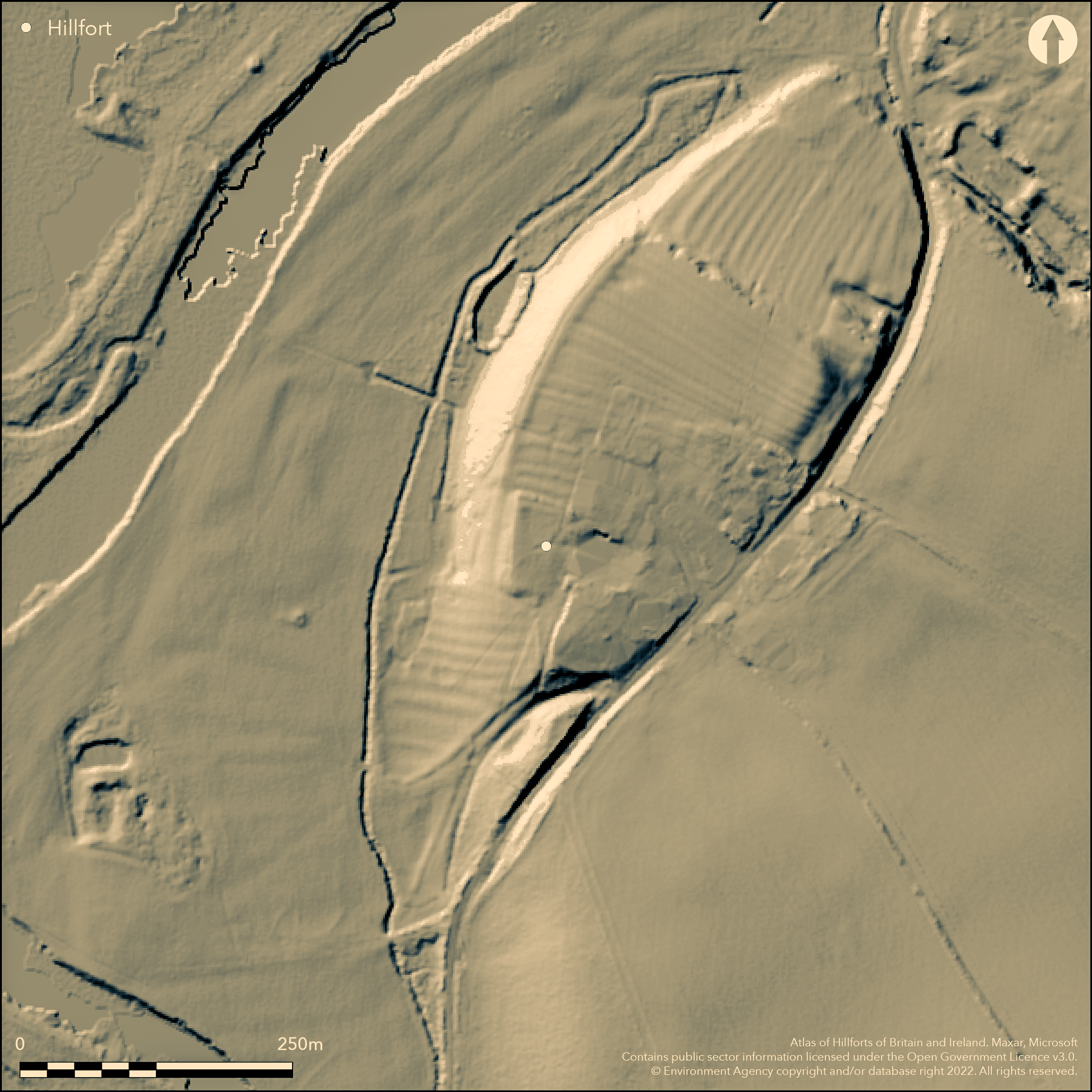
LiDAR 1m DTM Hillshade
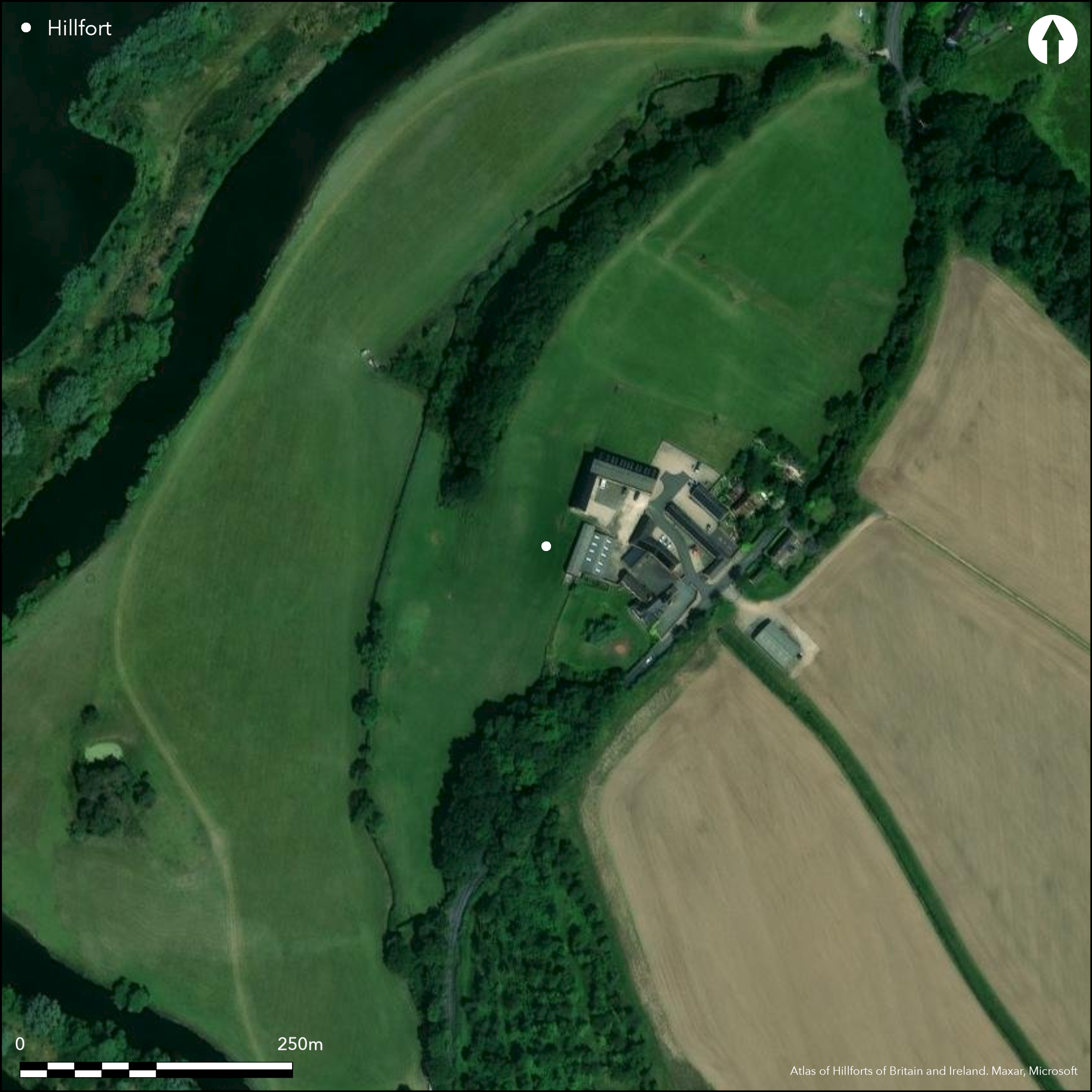
Satellite Imagery
LiDAR 1m DTM Hillshade
Satellite Imagery
Scroll left/right to view further images.
HER: Derbyshire 27506 (None)
NMR: SK 21 NW 4 (921465)
SM: 1017742
NGR: SK 20919 17406
X: 420919 Y: 317406 (OSGB36)
Lying 230m SW of Old Hall Cottage, a series of banks and terraces scheduled as a slight univallate hillfort. It lies on a level, naturally raised terrace at 61m OD, on the N, S and W sides are steep natural slopes and commanding views of the Trent flood plain. It is defined in the E by a sunken track. Approximately oval in form it measures 375m by 150m, encompassing 3.0ha. In the southern part of the hillfort are low banks constructed along the top edge of the natural slope in the W and S. Internally the ground is divided into two areas across the width of a steep slope. The land in the N, which was possibly terraced, is set 1m lower than in the S and occupies one-third of the internal area. An entrance in the E, which gives access to the northern section, carries a sunken corridor which continues for approximately 50m into the interior. A further entrance lies in the S. An L-shaped terrace stands 0.5m above the southern bank of the corridor running parallel to it before turning 90 degrees to run S along the eastern edge of the enclosure and into the southern section of the hillfort. A slight terrace cut into a natural break in the slope in the S was possibly a further entrance that provided access to the floodplain. The northern end of the terrace joins the bank in the S and E. Traces of medieval ridge and furrow now masks any internal features although slight terracing running E-W which divides the southern part of the enclosure into three terraces have been observed. Human remains were discovered in the southernmost section during the construction of modern farm buildings. Although currently scheduled as a hillfort, the site is undated and a review in 2004 offered a number of alternatives including a Roman fortification, a Mercian burh and a manorial precursor to Walton Old Hall (Guilbert 2004). Recorded on 1883 1:2,500 mapping.
Citizen Science: ✗
Reliability of Data: Confirmed
Reliability of Interpretation: Unconfirmed
X: -188297 Y: 6937594 (EPSG: 3857)
Longitude: -1.6915010296775355 Latitude: 52.7538416928589 (EPSG:4326)
Country: England
Current County or Unitary Authority: Derbyshire
Historic County: Derbyshire
Current Parish/Community/Council/Townland: Walton upon Trent
Modern farm buildings have resulted in some damage to the earthworks.
| Extant | ✓ |
| Cropmark | ✗ |
| Likely Destroyed | ✓ |
None
| Woodland | ✗ |
| Commercial Forestry Plantation | ✗ |
| Parkland | ✗ |
| Pasture (Grazing) | ✓ |
| Arable | ✗ |
| Scrub/Bracken | ✗ |
| Bare Outcrop | ✗ |
| Heather/Moorland | ✗ |
| Heath | ✗ |
| Built-up | ✗ |
| Coastal Grassland | ✗ |
| Other | ✗ |
A partial contour fort lying on a level, naturally raised terraced at 61m OD
| Contour Fort | ✗ |
| Partial Contour Fort | ✓ |
| Promontory Fort | ✗ |
| Hillslope Fort | ✗ |
| Level Terrain Fort | ✗ |
| Marsh Fort | ✗ |
| Multiple Enclosure Fort | ✗ |
| Hilltop | ✗ |
| Coastal Promontory | ✗ |
| Inland Promontory | ✗ |
| Valley Bottom | ✗ |
| Knoll/Hillock/Outcrop | ✗ |
| Ridge | ✗ |
| Cliff/Plateau-edge/Scarp | ✓ |
| Hillslope | ✗ |
| Lowland | ✓ |
| Spur | ✗ |
Dominant Topographic Feature: Naturally raised terrace
| North | ✗ |
| Northeast | ✗ |
| East | ✗ |
| Southeast | ✗ |
| South | ✗ |
| Southwest | ✗ |
| West | ✗ |
| Northwest | ✗ |
| Level | ✓ |
Altitude: 61.0m
N/A
The site is undated and from its morphology it could have been created in the Roman or later periods
Reliability: D - None
| Pre 1200BC | ✗ |
| 1200BC - 800BC | ✗ |
| 800BC - 400BC | ✗ |
| 400BC - AD50 | ✗ |
| AD50 - AD400 | ✗ |
| AD400 - AD 800 | ✗ |
| Post AD800 | ✗ |
| Unknown | ✓ |
| Pre Hillfort: | None |
| Post Hillfort: | Medieval ridge and furrow is still visible within the interior. Modern farm buildings |
General reference in Bulmer (1895). Recorded on 1883 1:2,500 mapping; RCHME field investigations in 1962 and 1966; 1993 RCHME National Forest Project.1985 Measured Survey. 2001 watching brief for replacement water pipe that runs across the enclosure. Part of the section of a cultivation bank was recorded and two small sections of deposits described as relating to the hillfort (Trebliug and Garton 2001).
| 1st Identified Written Reference (1895): | Bulmer (1895) |
| Other (1962): | Field investigation |
| Other (1966): | Field investigation |
| Earthwork Survey (1985): | South Derbyshire Archaeological Survey |
| Other (1998): | Scheduled |
| Other (2001): | Watching brief for replacement water pipe (Trebliug & Garton 2001) |
| 1st Identified Map Depiction (None): | None |
Traces of terracing running E-W divide the southern part of the hillfort into three terraces. Human remains discovered during the construction of the farm buildings
River Trent lies to the N, S and W
| None | ✓ |
| Spring | ✗ |
| Stream | ✗ |
| Pool | ✗ |
| Flush | ✗ |
| Well | ✗ |
| Other | ✗ |
Terracing
| No Known Features | ✗ |
| Round Stone Structures | ✗ |
| Rectangular Stone Structures | ✗ |
| Curvilinear Platforms | ✗ |
| Other Roundhouse Evidence | ✗ |
| Pits | ✗ |
| Quarry Hollows | ✗ |
| Other | ✓ |
None
| No Known Excavation | ✓ |
| Pits | ✗ |
| Postholes | ✗ |
| Roundhouses | ✗ |
| Rectangular Structures | ✗ |
| Roads/Tracks | ✗ |
| Quarry Hollows | ✗ |
| Other | ✗ |
| Nothing Found | ✗ |
None
| No Known Geophysics | ✓ |
| Pits | ✗ |
| Roundhouses | ✗ |
| Rectangular Structures | ✗ |
| Roads/Tracks | ✗ |
| Quarry Hollows | ✗ |
| Other | ✗ |
| Nothing Found | ✗ |
None
| No Known Finds | ✗ |
| Pottery | ✗ |
| Metal | ✗ |
| Metalworking | ✗ |
| Human Bones | ✓ |
| Animal Bones | ✗ |
| Lithics | ✗ |
| Environmental | ✗ |
| Other | ✗ |
None
| APs Not Checked | ✗ |
| None | ✓ |
| Roundhouses | ✗ |
| Rectangular Structures | ✗ |
| Pits | ✗ |
| Postholes | ✗ |
| Roads/Tracks | ✗ |
| Other | ✗ |
The entrance in the E, which gives access to the northern section carries a sunken corridor which continues for approximately 50m into the interior. A further gap entrance lies in the S cut into the terrace.
| 2: | None |
| 2: | None |
Guard Chambers: ✗
Chevaux de Frise: ✗
| 1. Hollow Way (East): | Outer bank |
| 2. Simple Gap (South): | Outer bank |
Recorded as a series of banks and terraces described as: Single linear earthwork rampart maximum length 30m, centred at SK 21081765. Single linear earthwork rampart maximum length 40m, centred at SK 21041752. Single linear earthwork rampart maximum length 70m, centred at 20901742. Single linear feature defined by one ditch and one bank maximum length of 30m, centred at SK 21091752 (summarised from Morph database)
| Area 1: | 3.0ha. |
| Total: | 3.0ha. |
Total Footprint Area: Noneha.
None
| ✗ | None |
| ✗ | None |
| NE Quadrant: | 2 |
| SE Quadrant: | 1 |
| SW Quadrant: | 1 |
| NW Quadrant: | 1 |
| Total: | 2 |
| Partial Univallate | ✓ |
| Univallate | ✗ |
| Partial Bivallate | ✓ |
| Bivallate | ✗ |
| Partial Multivallate | ✗ |
| Multivallate | ✗ |
| Unknown | ✗ |
| Partial Univallate | ✗ |
| Univallate | ✗ |
| Partial Bivallate | ✗ |
| Bivallate | ✗ |
| Partial Multivallate | ✗ |
| Multivallate | ✗ |
Recorded as a series of banks and terraces.
| None | ✗ |
| Earthen Bank | ✓ |
| Stone Wall | ✗ |
| Rubble | ✗ |
| Wall-walk | ✗ |
| Evidence of Timber | ✗ |
| Vitrification | ✗ |
| Other Burning | ✗ |
| Palisade | ✗ |
| Counter Scarp Bank | ✗ |
| Berm | ✗ |
| Unfinished | ✗ |
| Other | ✓ |
None
| None | ✗ |
| Earthen Bank | ✗ |
| Stone Wall | ✗ |
| Murus Duplex | ✗ |
| Timber-framed | ✗ |
| Timber-laced | ✗ |
| Vitrification | ✗ |
| Other Burning | ✗ |
| Palisade | ✗ |
| Counter Scarp Bank | ✗ |
| Berm | ✗ |
| Unfinished | ✗ |
| No Known Excavation | ✓ |
| Other | ✗ |
| ✗ | None |
| ✓ | None |
Number of Ditches: 1
| ✗ | None |
Bulmer, T. and Co., 1895. History, Topography and Directory of Derbyshire
Guilbert, G, 2004, Borough Hill, Walton-upon-Trent - if not a hillfort, then what? Derbyshire Archaeol J. 124, 242-257.
Trebliug, E. & Garton, D. 2001. Borough Hill, Walton on Trent. Trent and Peak Archaeological Unit. Unpublished
Atlas of Hillforts:
Wikidata:
This work is licensed under CC BY-SA 4.0

 and should be cited as:
Lock, Gary and Ralston, Ian. 2024. Atlas of Hillforts of Britain and Ireland. Available at: https://hillforts.arch.ox.ac.uk
Document Version 1.1