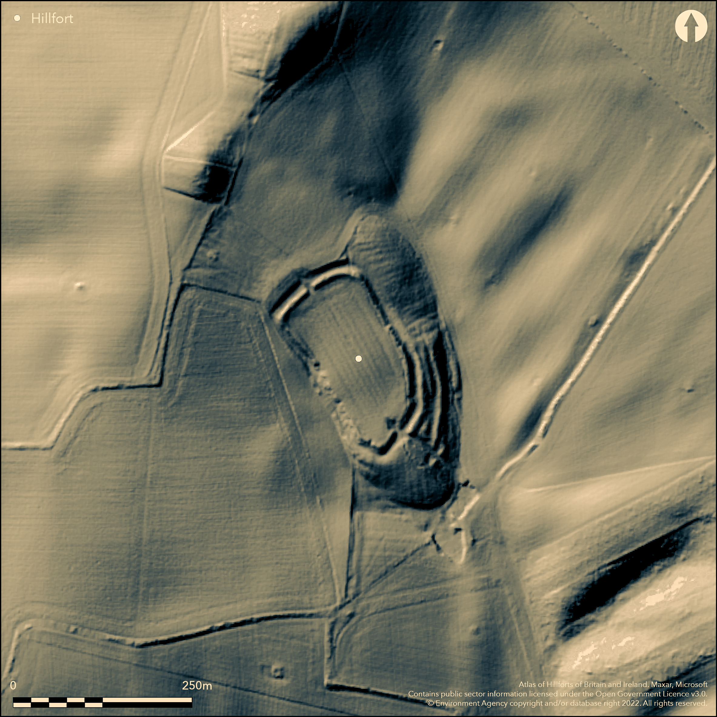
LiDAR 1m DTM Hillshade
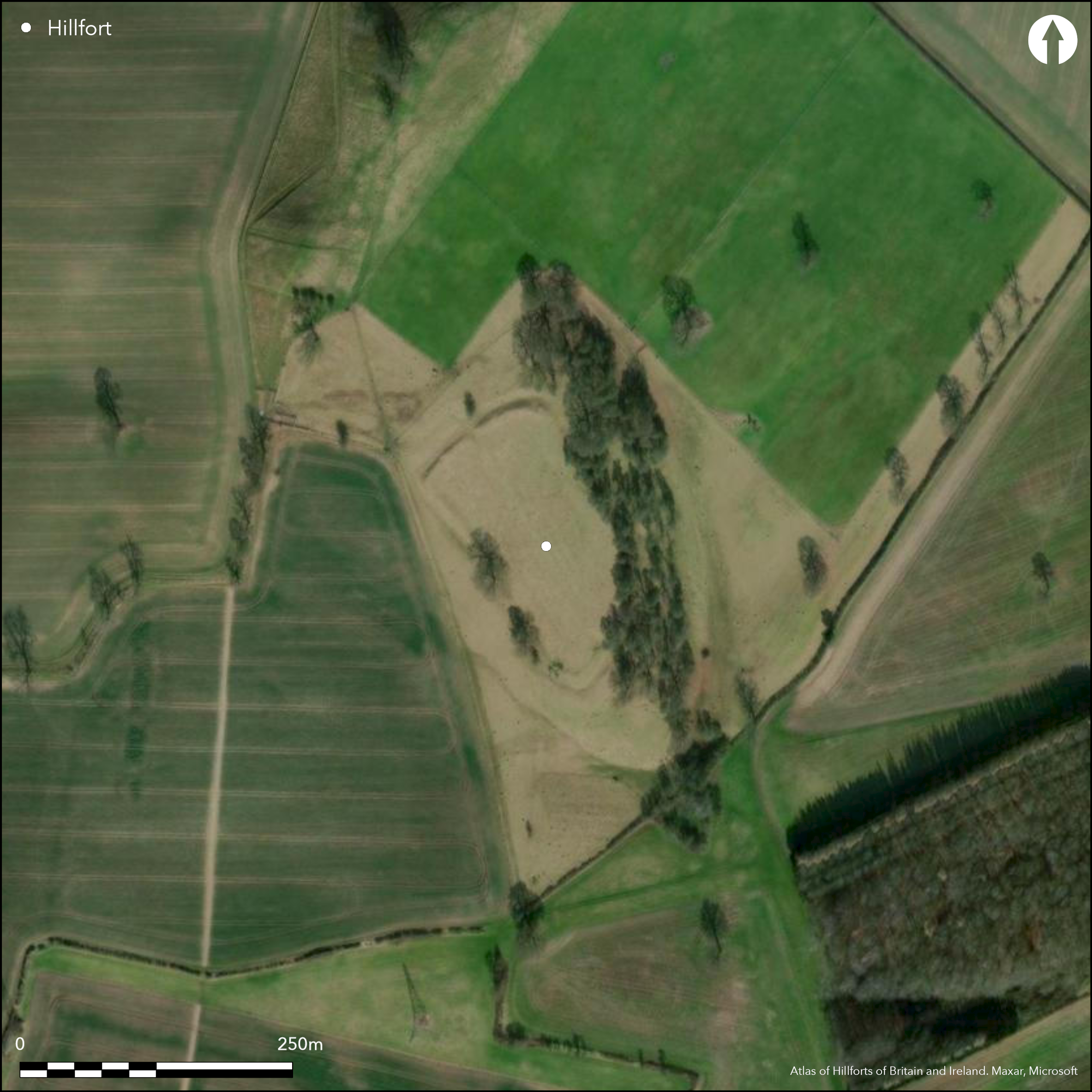
Satellite Imagery
LiDAR 1m DTM Hillshade
Satellite Imagery
Scroll left/right to view further images.
HER: Nottinghamshire 2772 (None)
NMR: SK 65 SW 7 (320283)
SM: 1003480
NGR: SK 6341 5319
X: 463418 Y: 353198 (OSGB36)
Lying at 105m OD to the NE of Oxton, a well preserved multivallate possible hillfort covering 0.8ha. The site occupies a gentle elongated Çbump' of land at the head of hollow or valley which extends away to the S and is overlooked by the summit. An elongated sub-oval in plan, it is multivallate in the SE, with two ditches, and was once bivallate to the SW, although the outer bank was virtually plough-levelled along the SW side during the course of the 20th century. Univallate at the NW end although it is unknown if an outer bank in this area was removed prior to its recording in the 20th century. Its location, in a hollow between two hills provides both seclusion and shelter but ensures the site is dominated by higher ground on all sides except in the SE where it is open. A simple causewayed entrance lies in the N and a more elaborate funnel-shaped entrance in the SE; the latter possibly a later feature contemporary with what might have been the strengthening of the bank and ditch to the N and W, as evidenced by a pronounced counterscarp which is mainly absent elsewhere. To the S of the SE entrance is a spring-fed pond although it is unknown if this was contemporary with the use of the enclosure. No internal features have been identified and the interior is overlain with ridge and furrow. Both its interpretation as a hillfort and its date as Iron Age have been questioned by Simmons (1963) and Bishop (East Midlands Archaeological Research Framework). The site is recorded on 1884-91 1:10,560 OS mapping. Scheduled
Citizen Science: ✗
Reliability of Data: Confirmed
Reliability of Interpretation: Unconfirmed
X: -117430 Y: 6996372 (EPSG: 3857)
Longitude: -1.0548949942474435 Latitude: 53.07224138091343 (EPSG:4326)
Country: England
Current County or Unitary Authority: Nottinghamshire
Historic County: Nottinghamshire
Current Parish/Community/Council/Townland: Oxton
None
| Extant | ✓ |
| Cropmark | ✗ |
| Likely Destroyed | ✗ |
Deciduous woodland along the ramparts in the SE
| Woodland | ✓ |
| Commercial Forestry Plantation | ✗ |
| Parkland | ✗ |
| Pasture (Grazing) | ✓ |
| Arable | ✗ |
| Scrub/Bracken | ✗ |
| Bare Outcrop | ✗ |
| Heather/Moorland | ✗ |
| Heath | ✗ |
| Built-up | ✗ |
| Coastal Grassland | ✗ |
| Other | ✗ |
A multivallate hillfort lying at 105m OD on a gentle elongated Çbump of land at the head of hollow or valley which extends away to the SE at and is overlooked by the summit.
| Contour Fort | ✗ |
| Partial Contour Fort | ✗ |
| Promontory Fort | ✗ |
| Hillslope Fort | ✓ |
| Level Terrain Fort | ✗ |
| Marsh Fort | ✗ |
| Multiple Enclosure Fort | ✗ |
| Hilltop | ✗ |
| Coastal Promontory | ✗ |
| Inland Promontory | ✗ |
| Valley Bottom | ✗ |
| Knoll/Hillock/Outcrop | ✗ |
| Ridge | ✗ |
| Cliff/Plateau-edge/Scarp | ✗ |
| Hillslope | ✓ |
| Lowland | ✗ |
| Spur | ✗ |
Dominant Topographic Feature: On a slope towards the top of a ridge known as Old Ox
| North | ✗ |
| Northeast | ✗ |
| East | ✗ |
| Southeast | ✓ |
| South | ✗ |
| Southwest | ✗ |
| West | ✗ |
| Northwest | ✗ |
| Level | ✗ |
Altitude: 105.0m
N/A
The site is undated.
Reliability: D - None
| Pre 1200BC | ✗ |
| 1200BC - 800BC | ✗ |
| 800BC - 400BC | ✗ |
| 400BC - AD50 | ✗ |
| AD50 - AD400 | ✗ |
| AD400 - AD 800 | ✗ |
| Post AD800 | ✗ |
| Unknown | ✓ |
| Pre Hillfort: | None |
| Post Hillfort: | Ridge and furrow ploughing |
Described in Rooke (1789) with earthwork plan, Recorded on 1884-91 1:10,560 OS mapping
| 1st Identified Written Reference (1789): | None |
| Earthwork Survey (1789): | None |
| 1st Identified Map Depiction (None): | None |
| Other (None): | Scheduled |
No internal features are recorded
A spring-fed pool lies to the S of the entrance in the SE
| None | ✓ |
| Spring | ✗ |
| Stream | ✗ |
| Pool | ✗ |
| Flush | ✗ |
| Well | ✗ |
| Other | ✗ |
None
| No Known Features | ✓ |
| Round Stone Structures | ✗ |
| Rectangular Stone Structures | ✗ |
| Curvilinear Platforms | ✗ |
| Other Roundhouse Evidence | ✗ |
| Pits | ✗ |
| Quarry Hollows | ✗ |
| Other | ✗ |
None
| No Known Excavation | ✓ |
| Pits | ✗ |
| Postholes | ✗ |
| Roundhouses | ✗ |
| Rectangular Structures | ✗ |
| Roads/Tracks | ✗ |
| Quarry Hollows | ✗ |
| Other | ✗ |
| Nothing Found | ✗ |
None
| No Known Geophysics | ✓ |
| Pits | ✗ |
| Roundhouses | ✗ |
| Rectangular Structures | ✗ |
| Roads/Tracks | ✗ |
| Quarry Hollows | ✗ |
| Other | ✗ |
| Nothing Found | ✗ |
None
| No Known Finds | ✓ |
| Pottery | ✗ |
| Metal | ✗ |
| Metalworking | ✗ |
| Human Bones | ✗ |
| Animal Bones | ✗ |
| Lithics | ✗ |
| Environmental | ✗ |
| Other | ✗ |
None
| APs Not Checked | ✓ |
| None | ✗ |
| Roundhouses | ✗ |
| Rectangular Structures | ✗ |
| Pits | ✗ |
| Postholes | ✗ |
| Roads/Tracks | ✗ |
| Other | ✗ |
Simple causewayed entrance in the N and a more elaborate funnel-shaped entrance in the SE; the latter possibly a later feature
| 2: | None |
| 2: | One of the entrances is possibly later, but contemporary with the use of the hillfort |
Guard Chambers: ✗
Chevaux de Frise: ✗
| 1. Simple Gap (North): | Causeway across ditch |
| 2. Passage-way/Corridor (South east): | Funnel-shaped |
Multivallate hillfort of 0.8ha. Elongated sub-oval in plan, it is multivallate in the SE, and was once bivallate to the SW, although the outer bank was virtually plough-levelled along the SW side during the course of the 20th century. Univallate at the NW end although it is unknown if an outer bank in this area was removed prior to its recording in the 20th century.
| Area 1: | 0.2ha. |
| Total: | 0.2ha. |
Total Footprint Area: 0.8ha.
None
| ✗ | Enclosed area of 0.2ha estimated by Hogg |
| ✓ | None |
| NE Quadrant: | 1 |
| SE Quadrant: | 3 |
| SW Quadrant: | 2 |
| NW Quadrant: | 1 |
| Total: | 3 |
| Partial Univallate | ✓ |
| Univallate | ✗ |
| Partial Bivallate | ✓ |
| Bivallate | ✗ |
| Partial Multivallate | ✓ |
| Multivallate | ✗ |
| Unknown | ✗ |
| Partial Univallate | ✗ |
| Univallate | ✗ |
| Partial Bivallate | ✗ |
| Bivallate | ✗ |
| Partial Multivallate | ✗ |
| Multivallate | ✗ |
None
| None | ✗ |
| Earthen Bank | ✓ |
| Stone Wall | ✗ |
| Rubble | ✗ |
| Wall-walk | ✗ |
| Evidence of Timber | ✗ |
| Vitrification | ✗ |
| Other Burning | ✗ |
| Palisade | ✗ |
| Counter Scarp Bank | ✓ |
| Berm | ✗ |
| Unfinished | ✗ |
| Other | ✗ |
None
| None | ✗ |
| Earthen Bank | ✗ |
| Stone Wall | ✗ |
| Murus Duplex | ✗ |
| Timber-framed | ✗ |
| Timber-laced | ✗ |
| Vitrification | ✗ |
| Other Burning | ✗ |
| Palisade | ✗ |
| Counter Scarp Bank | ✗ |
| Berm | ✗ |
| Unfinished | ✗ |
| No Known Excavation | ✓ |
| Other | ✗ |
| ✗ | None |
| ✓ | Two ditches in the SE. Rooke notes two ditch in the NE |
Number of Ditches: 2
| ✗ | None |
Bishop, M. East Midlands Archaeological Research Framework: Resource Assessment of 1st Millennium BC Nottinghamshire. www.le.ac.uk/ulas/publications/documents/20nott1stmill-000.pdf accessed May 2015
Rooke, H. 1789. Mr Rooke on the Roman Roads and Camps. Archaeologia 9, 201+ pl. XI.5
Simmons, B.B. 1963. Iron Age hill forts in Nottinghamshire. Trans Thoroton Soc Nottinghamshire, 67, 15-17
Atlas of Hillforts:
Wikidata:
This work is licensed under CC BY-SA 4.0

 and should be cited as:
Lock, Gary and Ralston, Ian. 2024. Atlas of Hillforts of Britain and Ireland. Available at: https://hillforts.arch.ox.ac.uk
Document Version 1.1