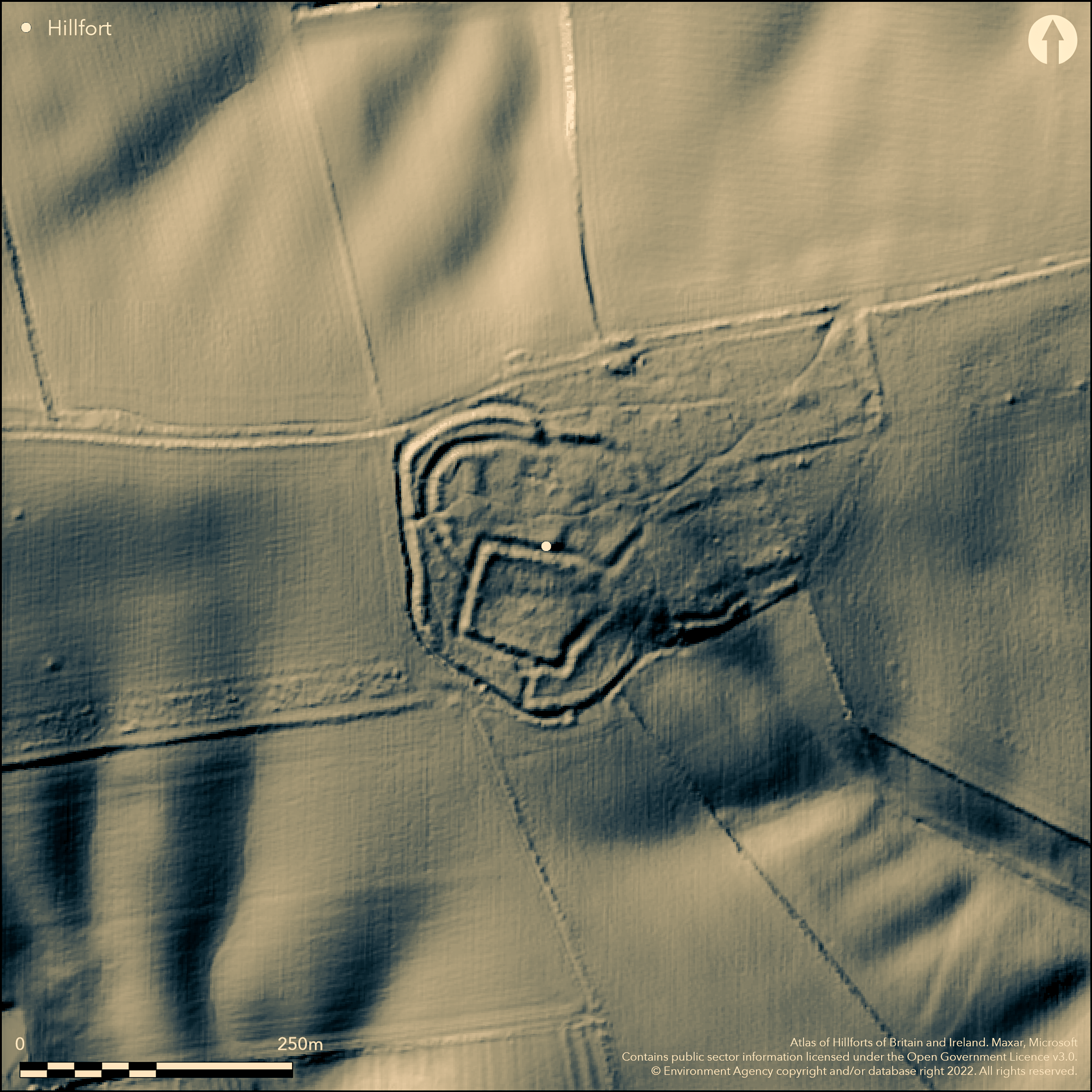
LiDAR 1m DTM Hillshade
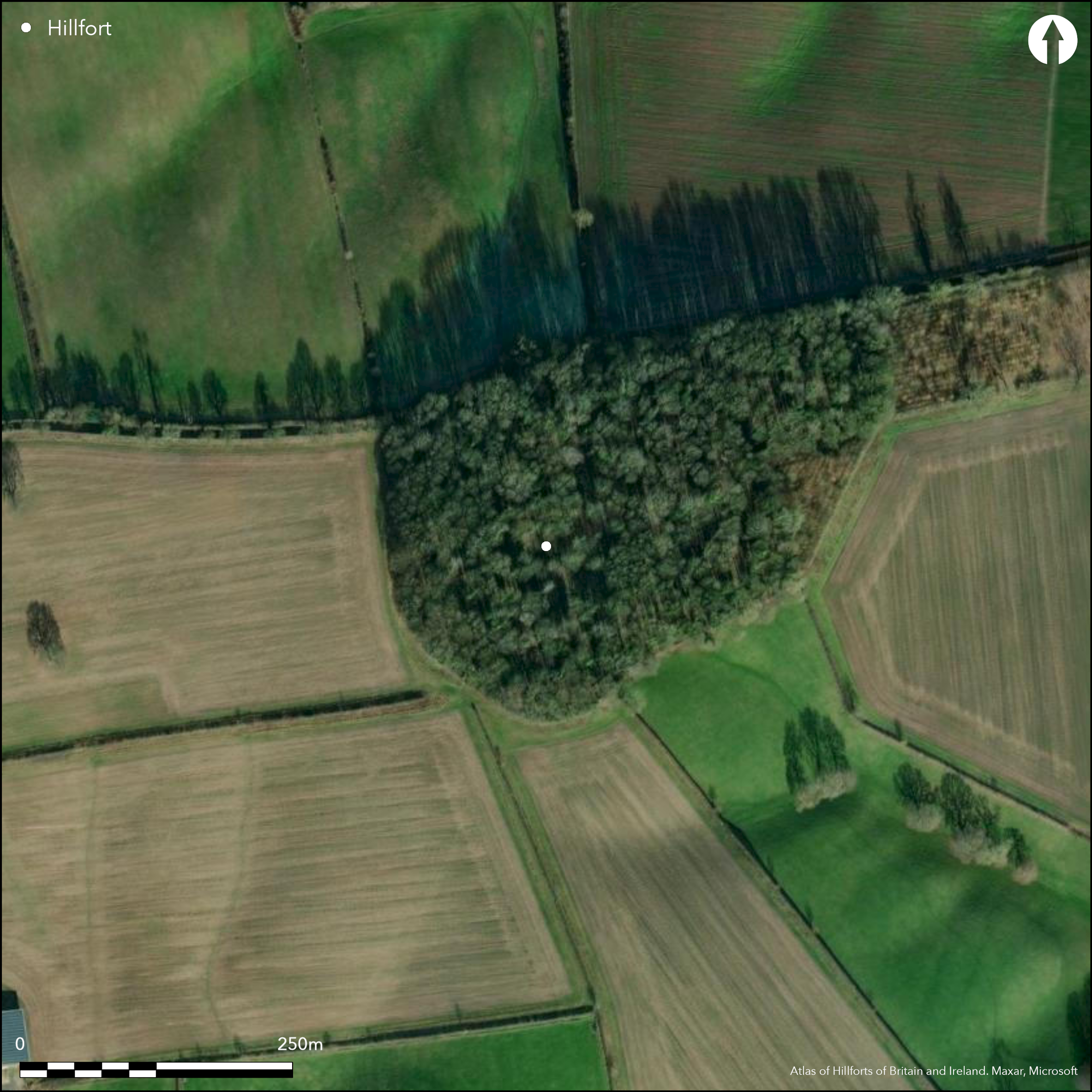
Satellite Imagery
LiDAR 1m DTM Hillshade
Satellite Imagery
Scroll left/right to view further images.
HER: Nottinghamshire 1752 (None)
NMR: SK 64 NW 10 (320019)
SM: 1006398
NGR: SK 61320 48404
X: 461320 Y: 348404 (OSGB36)
Lying approximately 500m to the S of the outskirts of Calverton and to the W of Bonner Hill, a multivallate system of banks and ditches straddling a long ridge within Fox Wood which may form part of a possible hillfort. The site lies on a SE-facing slope at 115m OD occupying approximately 3.6ha (earthwork plan in Chalkley Gould 1907). Multivallate except in the E where the earthworks appeared open with no evidence that any ever existed in this area. Within the main set of earthworks is a smaller enclosure of a different construction to the outer earthworks and probably later but which also appeared open to the E. The outer ditch and a bank 3-4m high survive on the N side in the wood, the inner bank and ditch can still be discerned at the SW corner. A funnel-shaped entrance lies in the N leading to what was possibly an early E-W ridgeway road. An interpretation of the earthworks from 2m Environment Agency lidar by Keyworth (2012, 73-4) appears to show a sub-rectangular enclosure of 65m by 55m enclosing approximately 0.4ha. This overlies a larger, sub-oval enclosure measuring 115m by 55m, enclosing 0.49ha. Both appear to be complete with entrances in the E and with antennae ditches extending northeastwards to the ridgeway from the larger enclosure. Both are enclosed within a larger ditch. The site is considered to have begun as a simple defended enclosure with strengthening of the defences during two later phases. Single sherds of both Roman and Iron Age pottery have been recovered from Fox Wood. The site is scheduled but no designation is given. Oswald (1939) reported an extension of the earthworks to the E, from which Iron Age and 3rd century Roman pottery has been recovered from the ploughland. These have since been plotted as cropmarks by English Heritage. It is uncertain if or how these relate to the earthworks within Fox Wood. The eastern cropmarks were investigated by Pre-Construct Archaeology and local volunteers in 2005 (Hamilton 2007) using fieldwalking, metal detecting and excavation which produced finds from all periods. A gold 'I' Stater 100-200 BC and a single fragment of decorated pottery was recovered during field walking. A combined plot of the earthworks and fieldwalking results are shown in Keyworth (2012, 27). The earthworks are recorded on 1885 1:2,500 OS mapping. Scheduled
Citizen Science: ✗
Reliability of Data: Unconfirmed
Reliability of Interpretation: Unconfirmed
X: -121017 Y: 6988437 (EPSG: 3857)
Longitude: -1.087115965385941 Latitude: 53.02939683795001 (EPSG:4326)
Country: England; None
Current County or Unitary Authority: Nottinghamshire
Historic County: Nottinghamshire
Current Parish/Community/Council/Townland: Woodborough; Calverton
Cropmarks outside the wood are possibly related to the features in Fox Wood
| Extant | ✓ |
| Cropmark | ✓ |
| Likely Destroyed | ✗ |
Broadleaf woodland; Entry Level plus Higher Level Stewardship - AG00592051
| Woodland | ✓ |
| Commercial Forestry Plantation | ✗ |
| Parkland | ✗ |
| Pasture (Grazing) | ✗ |
| Arable | ✗ |
| Scrub/Bracken | ✗ |
| Bare Outcrop | ✗ |
| Heather/Moorland | ✗ |
| Heath | ✗ |
| Built-up | ✗ |
| Coastal Grassland | ✗ |
| Other | ✗ |
A multiple-ditched system(s) lying on a SE-facing slope at 115m OD.
| Contour Fort | ✗ |
| Partial Contour Fort | ✗ |
| Promontory Fort | ✗ |
| Hillslope Fort | ✓ |
| Level Terrain Fort | ✗ |
| Marsh Fort | ✗ |
| Multiple Enclosure Fort | ✗ |
| Hilltop | ✗ |
| Coastal Promontory | ✗ |
| Inland Promontory | ✗ |
| Valley Bottom | ✗ |
| Knoll/Hillock/Outcrop | ✗ |
| Ridge | ✗ |
| Cliff/Plateau-edge/Scarp | ✗ |
| Hillslope | ✓ |
| Lowland | ✗ |
| Spur | ✗ |
Dominant Topographic Feature: SE-facing slope
| North | ✗ |
| Northeast | ✗ |
| East | ✗ |
| Southeast | ✓ |
| South | ✗ |
| Southwest | ✗ |
| West | ✗ |
| Northwest | ✗ |
| Level | ✗ |
Altitude: 115.0m
The parish boundary between Woodborough and Calverton lies to the N
Boundary Type: Parish/Townland
Roman pottery recovered from Fox Wood (Bishop 2001) suggests a later or continued use of the monument.
Reliability: D - None
| Pre 1200BC | ✗ |
| 1200BC - 800BC | ✗ |
| 800BC - 400BC | ✗ |
| 400BC - AD50 | ✗ |
| AD50 - AD400 | ✗ |
| AD400 - AD 800 | ✗ |
| Post AD800 | ✗ |
| Unknown | ✓ |
| Pre Hillfort: | None |
| Post Hillfort: | Roman pottery |
| Artefactual: | None |
Earthwork plan (Chalkley Gould 1907). An unauthorised excavation by Peverel Archaeological Group in 1946 was stopped due to it being a scheduled site. Field investigation 1975. 2007 Investigation of cropmarks outside of Fox wood through fieldwalking, metal detecting and excavation by Pre-Construct Archaeology. Lidar survey c. 2012
| 1st Identified Written Reference (1907): | None |
| Other (1975): | Field investigation |
| Other (2007): | Field work |
| Excavation (None): | None |
| LiDAR Survey (None): | None |
| Other (None): | Scheduled |
No internal features have been identified. Single sherds of both Roman and Iron Age pottery
None
| None | ✓ |
| Spring | ✗ |
| Stream | ✗ |
| Pool | ✗ |
| Flush | ✗ |
| Well | ✗ |
| Other | ✗ |
None
| No Known Features | ✓ |
| Round Stone Structures | ✗ |
| Rectangular Stone Structures | ✗ |
| Curvilinear Platforms | ✗ |
| Other Roundhouse Evidence | ✗ |
| Pits | ✗ |
| Quarry Hollows | ✗ |
| Other | ✗ |
None
| No Known Excavation | ✓ |
| Pits | ✗ |
| Postholes | ✗ |
| Roundhouses | ✗ |
| Rectangular Structures | ✗ |
| Roads/Tracks | ✗ |
| Quarry Hollows | ✗ |
| Other | ✗ |
| Nothing Found | ✗ |
None
| No Known Geophysics | ✓ |
| Pits | ✗ |
| Roundhouses | ✗ |
| Rectangular Structures | ✗ |
| Roads/Tracks | ✗ |
| Quarry Hollows | ✗ |
| Other | ✗ |
| Nothing Found | ✗ |
Single sherds of both Roman and Iron pottery recovered from Fox Wood
| No Known Finds | ✗ |
| Pottery | ✓ |
| Metal | ✗ |
| Metalworking | ✗ |
| Human Bones | ✗ |
| Animal Bones | ✗ |
| Lithics | ✗ |
| Environmental | ✗ |
| Other | ✗ |
Woodland
| APs Not Checked | ✓ |
| None | ✗ |
| Roundhouses | ✗ |
| Rectangular Structures | ✗ |
| Pits | ✗ |
| Postholes | ✗ |
| Roads/Tracks | ✗ |
| Other | ✗ |
A simple gap entrance with antennae ditches lies in the E
| 1: | None |
| 2: | None |
Guard Chambers: ✗
Chevaux de Frise: ✗
| 1. Other Forms (East): | Antennae ditches |
Multivallate system of banks and ditches. The sub-oval enclosure measures 0.49ha
| Area 1: | Noneha. |
| Total: | Noneha. |
Total Footprint Area: 0.49ha.
None
| ✗ | Area estimated from dimensions given in Keyworth (2012) |
| ✗ | None |
| NE Quadrant: | 1 |
| SE Quadrant: | 1 |
| SW Quadrant: | 1 |
| NW Quadrant: | 1 |
| Total: | 1 |
| Partial Univallate | ✗ |
| Univallate | ✓ |
| Partial Bivallate | ✗ |
| Bivallate | ✗ |
| Partial Multivallate | ✗ |
| Multivallate | ✗ |
| Unknown | ✗ |
| Partial Univallate | ✗ |
| Univallate | ✗ |
| Partial Bivallate | ✗ |
| Bivallate | ✗ |
| Partial Multivallate | ✗ |
| Multivallate | ✗ |
None
| None | ✗ |
| Earthen Bank | ✓ |
| Stone Wall | ✗ |
| Rubble | ✗ |
| Wall-walk | ✗ |
| Evidence of Timber | ✗ |
| Vitrification | ✗ |
| Other Burning | ✗ |
| Palisade | ✗ |
| Counter Scarp Bank | ✗ |
| Berm | ✗ |
| Unfinished | ✗ |
| Other | ✗ |
None
| None | ✓ |
| Earthen Bank | ✗ |
| Stone Wall | ✗ |
| Murus Duplex | ✗ |
| Timber-framed | ✗ |
| Timber-laced | ✗ |
| Vitrification | ✗ |
| Other Burning | ✗ |
| Palisade | ✗ |
| Counter Scarp Bank | ✗ |
| Berm | ✗ |
| Unfinished | ✗ |
| No Known Excavation | ✗ |
| Other | ✗ |
| ✗ | None |
| ✓ | Lidar appears to show a sub-oval ditch |
Number of Ditches: 1
| ✗ | None |
Chalkley Gould, I. 1907. Some Nottinghamshire Strongholds. J of the British Archaeol Ass, Second series, 13, 1907, 51-64. https://www.nottshistory.org.uk/articles/misc/nottsstrongholds1.htm. Accessed Jun 2015
Hamilton, L. 2007. Archaeological Excavation Report: Foxwood, Nottinghamshire. Pre-Construct Archaeology report (PCA-05-184). Unpublished
Keyworth, T. 2012. An Archaeological Synthesis and Landscape Investigation of Iron Age and Romano-British Central Nottinghamshire. MA dissertation, University of Leicester. https://www.academia.edu/7064496/MA-Dissertation-An-Archaeological-Synthesis-and-Landscape-Investigation-of-Iron-Age-and-Romano-British-Central-Nottinghamshire. Accessed Jun 2015.
Oswald, A. 1939. Some Unrecorded Earthworks in Nottinghamshire. Trans Thoroton Soc Nottinghamshire. XLIII. 15
Simmons, B.B. 1963. Iron Age Hill Forts in Nottinghamshire. Trans Thoroton Soc Nottinghamshire. LXVII. 17-18
Atlas of Hillforts:
Wikidata:
This work is licensed under CC BY-SA 4.0

 and should be cited as:
Lock, Gary and Ralston, Ian. 2024. Atlas of Hillforts of Britain and Ireland. Available at: https://hillforts.arch.ox.ac.uk
Document Version 1.1