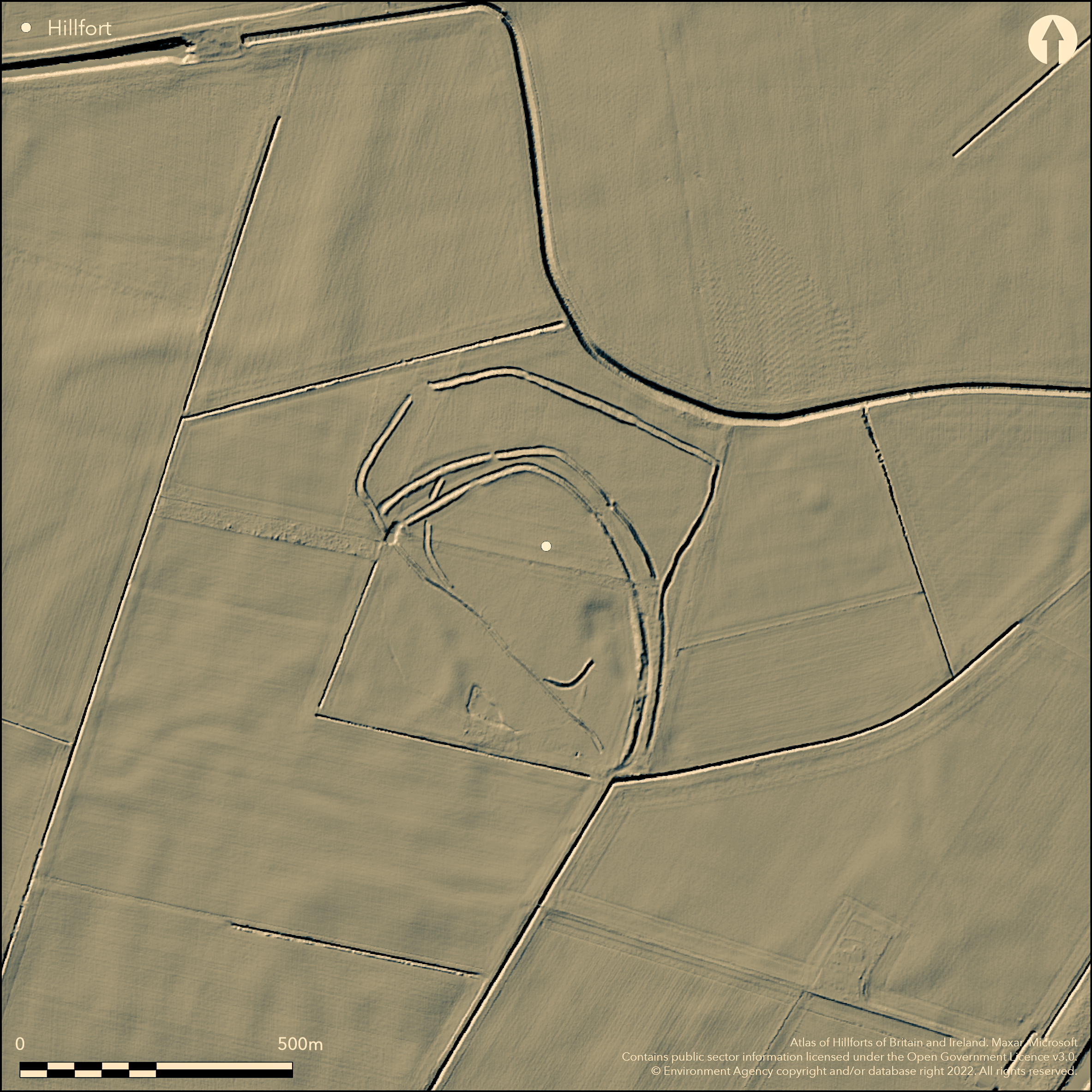
LiDAR 1m DTM Hillshade
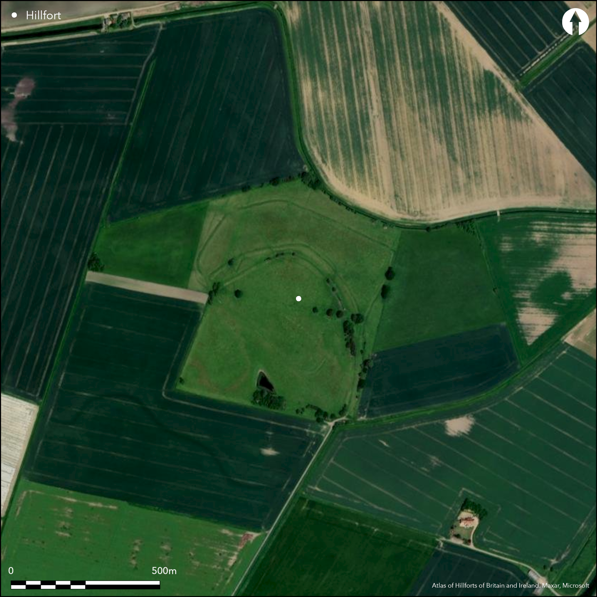
Satellite Imagery
LiDAR 1m DTM Hillshade
Satellite Imagery
Scroll left/right to view further images.
HER: Cambridgeshire 6033 (None)
NMR: TL 4 9 SW 1 (372473)
SM: 1012539
NGR: TL 4480 9301
X: 544788 Y: 293087 (OSGB36)
Situated to the NE of Wimblington, low lying on an island of gravel in the Fens with the S and SW sides of the enclosure originally being at the Fen edge. Aerial photography and excavation suggest that the earthworks had also been complemented by a network of now extinct water channels. The whole site was virtually ploughed away by the 1960s but parts have subsequently been reconstructed. A complex site of at least four phases (Malim 2005) with the two most distinct phases enclosing 9.6 hectares and 4.0 hectares respectively. The larger accepted phase 1 earthworks are a univallate enclosure still ploughed out but visible as broad light coloured soil marks on the line of the banks. About 250m length of 6.0m wide ditch extends N-S on the extreme E side, the only extant remains of phase 1. The final works comprise a bivallate arc forming a D-shape cutting off the 'promontory' against the fen edge. About 100m length of rampart and ditch to the NW is the only remains of the outer work, while the inner earthwork survives largely as a re-shaped ditch about 6.0m wide and 1-2m deep, except on the E side where the work is best preserved and rampart and ditch are largely complete, although mutilated, the rampart being 7m wide and 1m high. All of the connecting cross-works to the SW have been ploughed out, but again, their Fen contoured course can be traced as soil marks. The Phase 2 enclosure makes little attempt to incorporate or utilise the earlier works. Original entrances are unclear as there are many breaks through the ramparts although early maps record two gaps, one adjacent to the modern quarry in the SE and at least 30m wide, whilst a second, smaller gap was only 5m wide. The interior is uneven mainly due to 19th century gravel quarrying. Small scale excavations in 1959, 1980 (Jackson and Potter 1996) and 1990-92 (Malim 1992; 2005). In 1980 a section was cut through the inner rampart and ditch on the NW (best preserved) side and a limited area of the interior was excavated showing an earthen rampart and U-shaped ditch. The rampart was of simple `dump' construction. The lower fill of the ditch consisted of a solid mass of peat turves, still individually identifiable, preserved stakes in the ditch from rampart revetment. There was no silting beneath these turves and no evidence for cleaning out of the ditch. The turves themselves probably represent the upper part of the rampart, deliberately thrown back into the ditch. The lack of silting beneath the turves suggest this destruction occurred comparatively soon after the building of the defence. Finds from the excavation, surface collections and C14 dates ranging from 410 cal BC to cal 10 AD show that the camp was first constructed in the Middle Iron Age (3rd/2nd centuries BC) and continued until the 1st century AD. In 1990 a programme of work to prevent further damage to the site resulted in trial excavation of the enclosure banks and survey which indicated the former existence of additional ditches, and demonstrated the presence of well preserved organic remains, including human remains . A range of finds including Iron Age and Roman pottery, shell and burnt flint have been recovered during fieldwalking and metal detecting. This also includes a hoard with gold coins of Cunobelin and silver coins of the Coritani/Coieltauvi; a hoard of silver coins of the Iceni along with some denarii; a hoard of aes with some of Claudian date; plus numerous individual or small groups of coins, many Iceni, but also including potin coins and Roman coins of which the latest belong to the late 4th century AD. The Roman town of Stonea was developed nearby and it has been suggested that Stonea Camp was part of a wider oppidum of the Iceni. The site is unparalleled in Cambridgeshire and the surrounding area. There is little evidence for occupation of the interior. Between one and three ploughed out round barrows within the enclosure, Palaeolithic handaxe, evidence of Neolithic and Bronze age activity. On 1st Ed OS map (1885-1900).
Citizen Science: ✓
Reliability of Data: Confirmed
Reliability of Interpretation: Confirmed
X: 14735 Y: 6894042 (EPSG: 3857)
Longitude: 0.13236454276783294 Latitude: 52.516406248921434 (EPSG:4326)
Country: England
Current County or Unitary Authority: Cambridgeshire
Historic County: Cambridgeshire
Current Parish/Community/Council/Townland: Wimblington
None
| Extant | ✓ |
| Cropmark | ✓ |
| Likely Destroyed | ✗ |
None
| Woodland | ✗ |
| Commercial Forestry Plantation | ✗ |
| Parkland | ✗ |
| Pasture (Grazing) | ✓ |
| Arable | ✗ |
| Scrub/Bracken | ✗ |
| Bare Outcrop | ✗ |
| Heather/Moorland | ✗ |
| Heath | ✗ |
| Built-up | ✗ |
| Coastal Grassland | ✗ |
| Other | ✗ |
A complex site of multiple phases, low lying on an island of gravel in the Fens.
| Contour Fort | ✗ |
| Partial Contour Fort | ✗ |
| Promontory Fort | ✗ |
| Hillslope Fort | ✗ |
| Level Terrain Fort | ✓ |
| Marsh Fort | ✓ |
| Multiple Enclosure Fort | ✗ |
| Hilltop | ✗ |
| Coastal Promontory | ✗ |
| Inland Promontory | ✗ |
| Valley Bottom | ✗ |
| Knoll/Hillock/Outcrop | ✗ |
| Ridge | ✗ |
| Cliff/Plateau-edge/Scarp | ✗ |
| Hillslope | ✗ |
| Lowland | ✓ |
| Spur | ✗ |
Dominant Topographic Feature: low lying on an island of gravel in the Fens.
| North | ✗ |
| Northeast | ✗ |
| East | ✗ |
| Southeast | ✗ |
| South | ✗ |
| Southwest | ✗ |
| West | ✗ |
| Northwest | ✗ |
| Level | ✓ |
Altitude: 2.0m
N/A
Four C14 dates and Iron Age pottery suggest construction in the 3rd-2nd centuries BC continuing into 1st century AD. Between one and three ploughed out round barrows within the enclosure, Palaeolithic handaxe, evidence of Neolithic activity. Roman pottery and coins. Possible Viking use. Civil War use.
Reliability: B - Medium
| Pre 1200BC | ✗ |
| 1200BC - 800BC | ✗ |
| 800BC - 400BC | ✗ |
| 400BC - AD50 | ✓ |
| AD50 - AD400 | ✗ |
| AD400 - AD 800 | ✗ |
| Post AD800 | ✗ |
| Unknown | ✗ |
| Pre Hillfort: | None |
| Post Hillfort: | None |
| Artefactual: | None |
| C14: | None |
On 1st Ed OS map (1885-1900). Small scale excavations in 1959, 1980 with geophysics (Jackson and Potter 1996) and 1990-92 (Malim 1992).
| Excavation (1959): | None |
| 1st Identified Map Depiction (None): | None |
| Excavation (None): | None |
| Geophysical Survey (None): | None |
| Excavation (None): | None |
No evidence for internal features. A range of finds including Iron Age and Roman pottery, shell and burnt flint have been recovered during fieldwalking and metal detecting. This also includes a hoard with gold coins of Cunobelin and silver coins of the Coritani/Coieltauvi; a hoard of silver coins of the Iceni along with some denarii; a hoard of aes with some of Claudian date; plus numerous individual or small groups of coins, many Iceni, but also including potin coins and Roman coins of which the latest belong to the late 4th century AD.
Surrounded by Fen
| None | ✓ |
| Spring | ✗ |
| Stream | ✗ |
| Pool | ✗ |
| Flush | ✗ |
| Well | ✗ |
| Other | ✗ |
None
| No Known Features | ✓ |
| Round Stone Structures | ✗ |
| Rectangular Stone Structures | ✗ |
| Curvilinear Platforms | ✗ |
| Other Roundhouse Evidence | ✗ |
| Pits | ✗ |
| Quarry Hollows | ✗ |
| Other | ✗ |
None
| No Known Excavation | ✗ |
| Pits | ✗ |
| Postholes | ✗ |
| Roundhouses | ✗ |
| Rectangular Structures | ✗ |
| Roads/Tracks | ✗ |
| Quarry Hollows | ✗ |
| Other | ✗ |
| Nothing Found | ✓ |
None
| No Known Geophysics | ✗ |
| Pits | ✗ |
| Roundhouses | ✗ |
| Rectangular Structures | ✗ |
| Roads/Tracks | ✗ |
| Quarry Hollows | ✗ |
| Other | ✗ |
| Nothing Found | ✓ |
None
| No Known Finds | ✗ |
| Pottery | ✓ |
| Metal | ✓ |
| Metalworking | ✗ |
| Human Bones | ✓ |
| Animal Bones | ✓ |
| Lithics | ✓ |
| Environmental | ✓ |
| Other | ✗ |
NO APPARENT FEATURES
| APs Not Checked | ✓ |
| None | ✗ |
| Roundhouses | ✗ |
| Rectangular Structures | ✗ |
| Pits | ✗ |
| Postholes | ✗ |
| Roads/Tracks | ✗ |
| Other | ✗ |
Numerous breaks through the ramparts, possible original entrance to SE, a 30m wide gap
| None: | None |
| 2: | None |
Guard Chambers: ✗
Chevaux de Frise: ✗
| 1. Simple Gap (South east): | None |
A complex site of at least four phases (Malim 2005) with the two most distinct phases enclosing 9.6 hectares and 4.0 hectares respectively. The larger accepted phase 1 earthworks are a univallate enclosure still ploughed out but visible as broad light coloured soil marks on the line of the banks. About 250m length of 6.0m wide ditch extends N-S on the extreme E side, the only extant remains of phase 1. The final works comprise a bivallate arc forming a D-shape cutting off the 'promontory' against the fen edge. About 100m length of rampart and ditch to the NW is the only remains of the outer work, while the inner earthwork survives largely as a re-shaped ditch about 6.0m wide and 1-2m deep, except on the E side where the work is best preserved and rampart and ditch are largely complete, although mutilated, the rampart being 7m wide and 1m high. All of the connecting cross-works to the SW have been ploughed out, but again, their Fen contoured course can be traced as soil marks. The Phase 2 enclosure makes little attempt to incorporate or utilise the earlier works.
| Area 1: | 9.6ha. |
| Area 2: | 4.0ha. |
| Total: | 9.6ha. |
Total Footprint Area: Noneha.
None
| ✓ | None |
| ✓ | None |
| NE Quadrant: | 3 |
| SE Quadrant: | 2 |
| SW Quadrant: | 2 |
| NW Quadrant: | 3 |
| Total: | 3 |
| Partial Univallate | ✗ |
| Univallate | ✗ |
| Partial Bivallate | ✓ |
| Bivallate | ✗ |
| Partial Multivallate | ✓ |
| Multivallate | ✗ |
| Unknown | ✗ |
| Partial Univallate | ✗ |
| Univallate | ✓ |
| Partial Bivallate | ✓ |
| Bivallate | ✗ |
| Partial Multivallate | ✗ |
| Multivallate | ✗ |
None
| None | ✗ |
| Earthen Bank | ✓ |
| Stone Wall | ✗ |
| Rubble | ✗ |
| Wall-walk | ✗ |
| Evidence of Timber | ✗ |
| Vitrification | ✗ |
| Other Burning | ✗ |
| Palisade | ✗ |
| Counter Scarp Bank | ✗ |
| Berm | ✗ |
| Unfinished | ✗ |
| Other | ✗ |
Turf rampart collapsed into ditch, stakes for revetment
| None | ✗ |
| Earthen Bank | ✓ |
| Stone Wall | ✗ |
| Murus Duplex | ✗ |
| Timber-framed | ✗ |
| Timber-laced | ✗ |
| Vitrification | ✗ |
| Other Burning | ✗ |
| Palisade | ✗ |
| Counter Scarp Bank | ✗ |
| Berm | ✗ |
| Unfinished | ✗ |
| No Known Excavation | ✗ |
| Other | ✓ |
| ✗ | None |
| ✓ | None |
Number of Ditches: 3
| ✗ | None |
Jackson, R.P.J and Potter, T.W. 1996. Excavations at Stonea, Cambridgeshire 1980-85. London: British Museum Press.
Malim, T. 1992. Stonea Camp, Wimblington. An Iron Age Fort in the Fens. Interim report. Cambridgeshire County Council Archaeological Field Unit Report No. 71.
Malim, T. 2005. Stonea and the Roman Fens. Tempus.
Salzman, L.F. (ed). 1948. The Victoria history of the county of Cambridge and the Isle of Ely. Volume two, 46-7.
Atlas of Hillforts:
Wikidata:
This work is licensed under CC BY-SA 4.0

 and should be cited as:
Lock, Gary and Ralston, Ian. 2024. Atlas of Hillforts of Britain and Ireland. Available at: https://hillforts.arch.ox.ac.uk
Document Version 1.1