LiDAR 1m DTM Hillshade
Satellite Imagery
LiDAR 1m DTM Hillshade
Satellite Imagery
Scroll left/right to view further images.
HER: Cambridgeshire 4636 (None)
NMR: TL 4 5 SE 2 (371612)
SM: 1009395
NGR: TL 4940 5343
X: 549415 Y: 253429 (OSGB36)
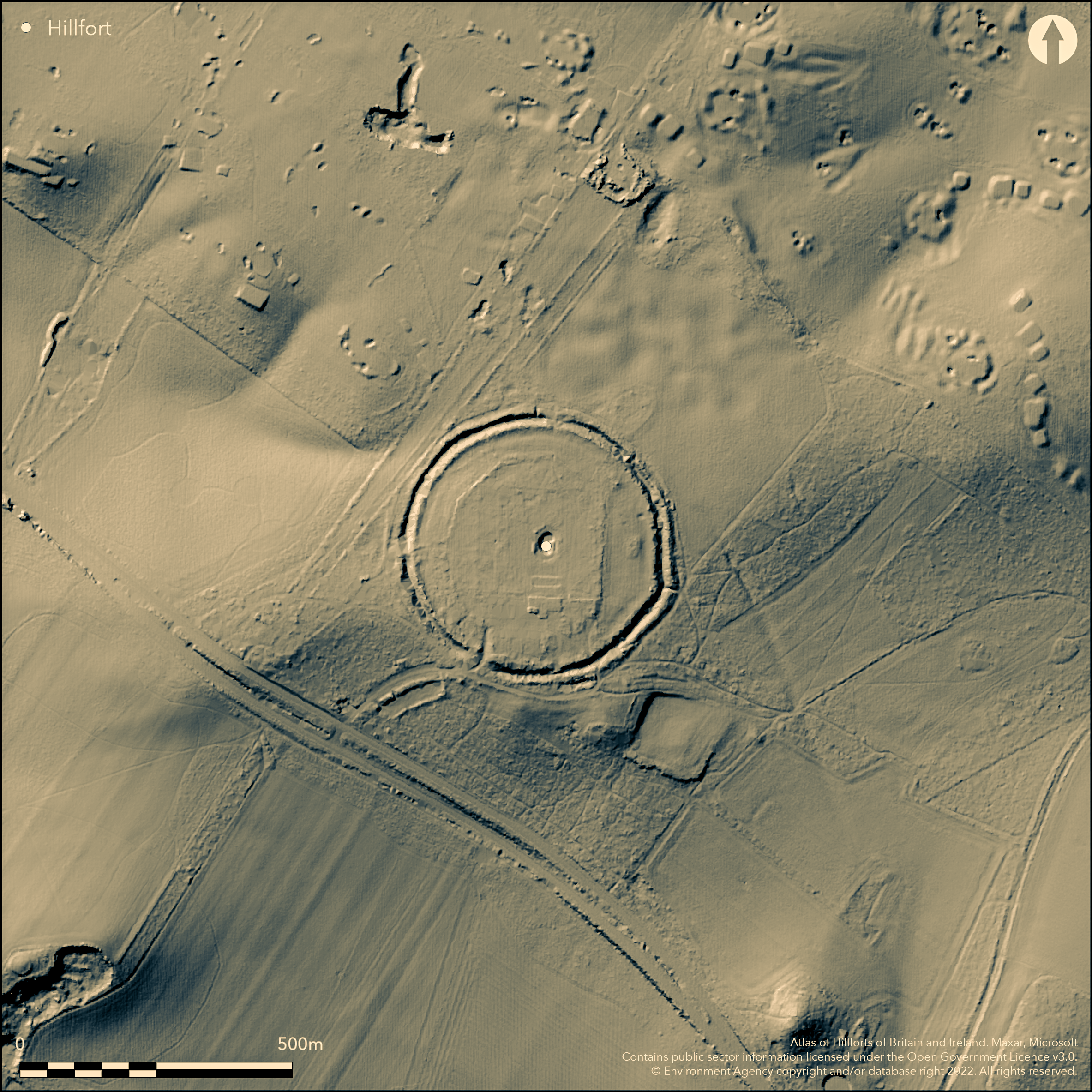
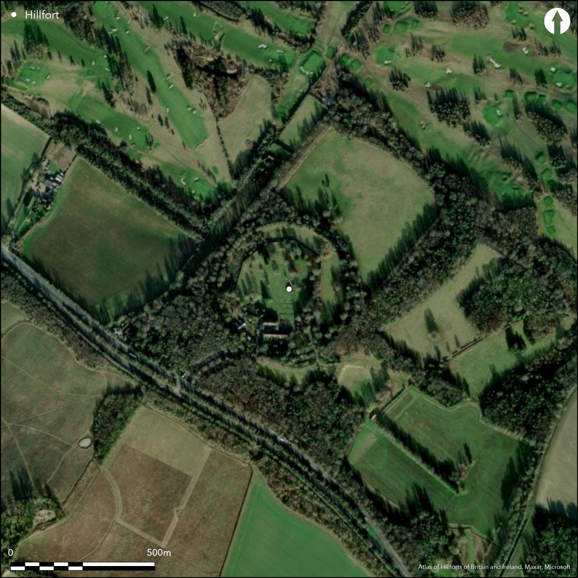
Situated SE of Cambridge on the Gog Magog Hills, a circular multivallate hillfort. It was originally encircled by a triple bank and ditch, but the inner bank and ditch were destroyed in 1694 when the ground was landscaped for the house, stables and formal gardens built within the enclosure by Lord Godolphin. The earthwork now consists of a double bank and ditch, the ditch being 2 to 3m deep and the ramparts up to 2m above ground level, the entire fort is c. 300m in diameter. Slight traces of the destroyed inner bank are apparent inside the existing works. Excavations in 1955-56 (Hartley 1957) showed the surviving ditch belongs to the earliest period of the fort and together with a timber revetted rampart 4.3m wide, was constructed in the 5th/4th century BC. The outer ditch had steep sides and was 4.6m deep and 2.4m wide across the bottom. This early phase univallate fort enclosed 6.25ha. The fort fell into disrepair and was abandoned for a lengthy period, but was refortified in the 1st century BC in its multivallate form reducing the enclosed area to 3.7ha (French 2004). The ditch was widened to 11.5m and 5m deep, the rampart was reconstructed of chalk rubble with a counter-scarp bank. A new inner V-shaped ditch and rampart were also constructed at this time. The interior was intensively occupied with evidence for roundhouse foundations and storage pits with grain as well as 'closing deposits' including fragments of human skeletons. There was evidence of some occupation during the Roman period, probably from the 2nd century AD, but no structures of this period were seen. Earthwork survey in 1994-95 (Pattison and Oswald 1996) identified a blocked entrance to the SE, probably the original entrance. A causeway across the ditch to the SW may be another entrance or medieval as one of the four causeways currently providing access. Further excavation and geophysical survey in 1994-7 (French 2004), both inside and outside the enclosure, showed evidence for a pre-hillfort settlement possibly a post built enclosure of the Late Bronze/Early Iron Age and then an open settlement of the 5th century BC, confirmed intensive occupation in the 4th century BC with lesser occupation through the late Iron Age and Roman periods, also confirmed the timber box rampart. At least seven skeletons found outside the SE entrance suggest an Iron Age cemetery there. Described in the 10th century Chronicle of Ramsey Abbey and then by Camden (1772), on 1st Ed OS map (1885-1900).
Citizen Science: ✓
Reliability of Data: Confirmed
Reliability of Interpretation: Confirmed
X: 20358 Y: 6828904 (EPSG: 3857)
Longitude: 0.1828799067883381 Latitude: 52.15887971591702 (EPSG:4326)
Country: England
Current County or Unitary Authority: Cambridgeshire
Historic County: Cambridgeshire
Current Parish/Community/Council/Townland: Stapleford
On Heritage at Risk Register (2015).
| Extant | ✓ |
| Cropmark | ✗ |
| Likely Destroyed | ✓ |
None
| Woodland | ✓ |
| Commercial Forestry Plantation | ✗ |
| Parkland | ✓ |
| Pasture (Grazing) | ✗ |
| Arable | ✗ |
| Scrub/Bracken | ✗ |
| Bare Outcrop | ✗ |
| Heather/Moorland | ✗ |
| Heath | ✗ |
| Built-up | ✓ |
| Coastal Grassland | ✗ |
| Other | ✗ |
A partial contour fort on a spur looking S
| Contour Fort | ✗ |
| Partial Contour Fort | ✓ |
| Promontory Fort | ✗ |
| Hillslope Fort | ✗ |
| Level Terrain Fort | ✗ |
| Marsh Fort | ✗ |
| Multiple Enclosure Fort | ✗ |
| Hilltop | ✗ |
| Coastal Promontory | ✗ |
| Inland Promontory | ✗ |
| Valley Bottom | ✗ |
| Knoll/Hillock/Outcrop | ✗ |
| Ridge | ✗ |
| Cliff/Plateau-edge/Scarp | ✗ |
| Hillslope | ✗ |
| Lowland | ✗ |
| Spur | ✓ |
Dominant Topographic Feature: on a spur
| North | ✗ |
| Northeast | ✗ |
| East | ✗ |
| Southeast | ✗ |
| South | ✓ |
| Southwest | ✗ |
| West | ✗ |
| Northwest | ✗ |
| Level | ✗ |
Altitude: 69.0m
N/A
Excavations have shown pre-hillfort Late Bronze Age/ Early Iron Age occupation. Hillfort constructed 4th century BC, abandonment then rebuilding 1st century BC. Occupation into Roman period. Landscaped for a house, stables and formal gardens in 1694.
Reliability: B - Medium
| Pre 1200BC | ✗ |
| 1200BC - 800BC | ✗ |
| 800BC - 400BC | ✓ |
| 400BC - AD50 | ✓ |
| AD50 - AD400 | ✗ |
| AD400 - AD 800 | ✗ |
| Post AD800 | ✗ |
| Unknown | ✗ |
| Pre Hillfort: | None |
| Post Hillfort: | None |
| Artefactual: | None |
Described in the 10th century Chronicle of Ramsey Abbey, and by Camden (1772), in Aubrey's Monumenta Britannica (1665-1693), on 1st Ed OS map (1885-1900). Excavations in 1955-56 (Hartley 1957), 1975-76 and 1994-97 (French 2004), geophysical survey in 1994 and 1998, earthwork survey in 1994-95, ref. no. 1079020 (Pattison and Oswald 1996).
| Geophysical Survey (1994): | None |
| Earthwork Survey (1994): | None |
| Geophysical Survey (1998): | None |
| 1st Identified Written Reference (None): | None |
| 1st Identified Map Depiction (None): | None |
| Excavation (None): | None |
| Excavation (None): | None |
| Excavation (None): | None |
A large range of domestic material culture from excavations, together with human skeletons, pits, postholes and houses.
None
| None | ✓ |
| Spring | ✗ |
| Stream | ✗ |
| Pool | ✗ |
| Flush | ✗ |
| Well | ✗ |
| Other | ✗ |
None
| No Known Features | ✓ |
| Round Stone Structures | ✗ |
| Rectangular Stone Structures | ✗ |
| Curvilinear Platforms | ✗ |
| Other Roundhouse Evidence | ✗ |
| Pits | ✗ |
| Quarry Hollows | ✗ |
| Other | ✗ |
None
| No Known Excavation | ✗ |
| Pits | ✓ |
| Postholes | ✓ |
| Roundhouses | ✓ |
| Rectangular Structures | ✓ |
| Roads/Tracks | ✗ |
| Quarry Hollows | ✗ |
| Other | ✗ |
| Nothing Found | ✗ |
None
| No Known Geophysics | ✗ |
| Pits | ✓ |
| Roundhouses | ✓ |
| Rectangular Structures | ✓ |
| Roads/Tracks | ✗ |
| Quarry Hollows | ✗ |
| Other | ✗ |
| Nothing Found | ✗ |
None
| No Known Finds | ✗ |
| Pottery | ✓ |
| Metal | ✗ |
| Metalworking | ✗ |
| Human Bones | ✓ |
| Animal Bones | ✓ |
| Lithics | ✗ |
| Environmental | ✓ |
| Other | ✓ |
NO APPARENT FEATURES
| APs Not Checked | ✓ |
| None | ✗ |
| Roundhouses | ✗ |
| Rectangular Structures | ✗ |
| Pits | ✗ |
| Postholes | ✗ |
| Roads/Tracks | ✗ |
| Other | ✗ |
Four causeways into the interior, probably medieval although SW may be original. Original blocked entrance to SE.
| 4: | None |
| 2: | None |
Guard Chambers: ✗
Chevaux de Frise: ✗
| 1. Blocked (South east): | None |
| 2. Simple Gap (South west): | None |
First phase univallate (6.25ha), remodelled to multivallate with three ramparts and ditches (3.7ha). Excavation has shown timber box rampart for first phase.
| Area 1: | 6.25ha. |
| Area 2: | 3.7ha. |
| Total: | 6.25ha. |
Total Footprint Area: Noneha.
None
| ✓ | None |
| ✓ | None |
| NE Quadrant: | 3 |
| SE Quadrant: | 3 |
| SW Quadrant: | 3 |
| NW Quadrant: | 3 |
| Total: | 3 |
| Partial Univallate | ✗ |
| Univallate | ✗ |
| Partial Bivallate | ✗ |
| Bivallate | ✗ |
| Partial Multivallate | ✗ |
| Multivallate | ✓ |
| Unknown | ✗ |
| Partial Univallate | ✗ |
| Univallate | ✓ |
| Partial Bivallate | ✗ |
| Bivallate | ✗ |
| Partial Multivallate | ✗ |
| Multivallate | ✓ |
None
| None | ✗ |
| Earthen Bank | ✓ |
| Stone Wall | ✗ |
| Rubble | ✗ |
| Wall-walk | ✗ |
| Evidence of Timber | ✗ |
| Vitrification | ✗ |
| Other Burning | ✗ |
| Palisade | ✗ |
| Counter Scarp Bank | ✗ |
| Berm | ✗ |
| Unfinished | ✗ |
| Other | ✗ |
None
| None | ✗ |
| Earthen Bank | ✓ |
| Stone Wall | ✗ |
| Murus Duplex | ✗ |
| Timber-framed | ✓ |
| Timber-laced | ✗ |
| Vitrification | ✗ |
| Other Burning | ✗ |
| Palisade | ✗ |
| Counter Scarp Bank | ✗ |
| Berm | ✗ |
| Unfinished | ✗ |
| No Known Excavation | ✗ |
| Other | ✗ |
| ✗ | None |
| ✓ | None |
Number of Ditches: 3
| ✗ | None |
Chaitlow, E.. 2004. A Bioarchaeological study of skeletons from Wandlebury Iron Age Hill Fort. Unpublished
French, C.. 2004. Evaluation survey and excavation at Wandlebury ringwork, Cambridgeshire, 1994-7. Proc Cambridge Antiq Soc, 93: 15-65.
Hartley, B.R.. 1957. The Wandlebury Iron Age Hill-Fort, Excavations of 1955-6. Proc Cambridge Antiq Soc, 50:1-27.
Pattison, P. and Oswald, A.. 1996. Wandlebury Hillfort, Cambridgeshire. RCHME Report Field Survey Report, NMR Number TL 45 SE 2. Unpublished.
Taylor, A.. 1977. Skeletons at Wandlebury Hill-fort. Proc Cambridge Antiq Soc, 67: 1.
Webley, L., 2005 Wandlebury Ringwork, Cambridgeshire 1994-97 Part II, The Iron Age Pottery. Proc Cambridge Antiq Soc, XCIV, 39-45.
Atlas of Hillforts:
Wikidata:
This work is licensed under CC BY-SA 4.0![]()
![]()
![]() and should be cited as:
and should be cited as:
Lock, Gary and Ralston, Ian. 2024. Atlas of Hillforts of Britain and Ireland. Available at: https://hillforts.arch.ox.ac.uk
Document Version 1.1