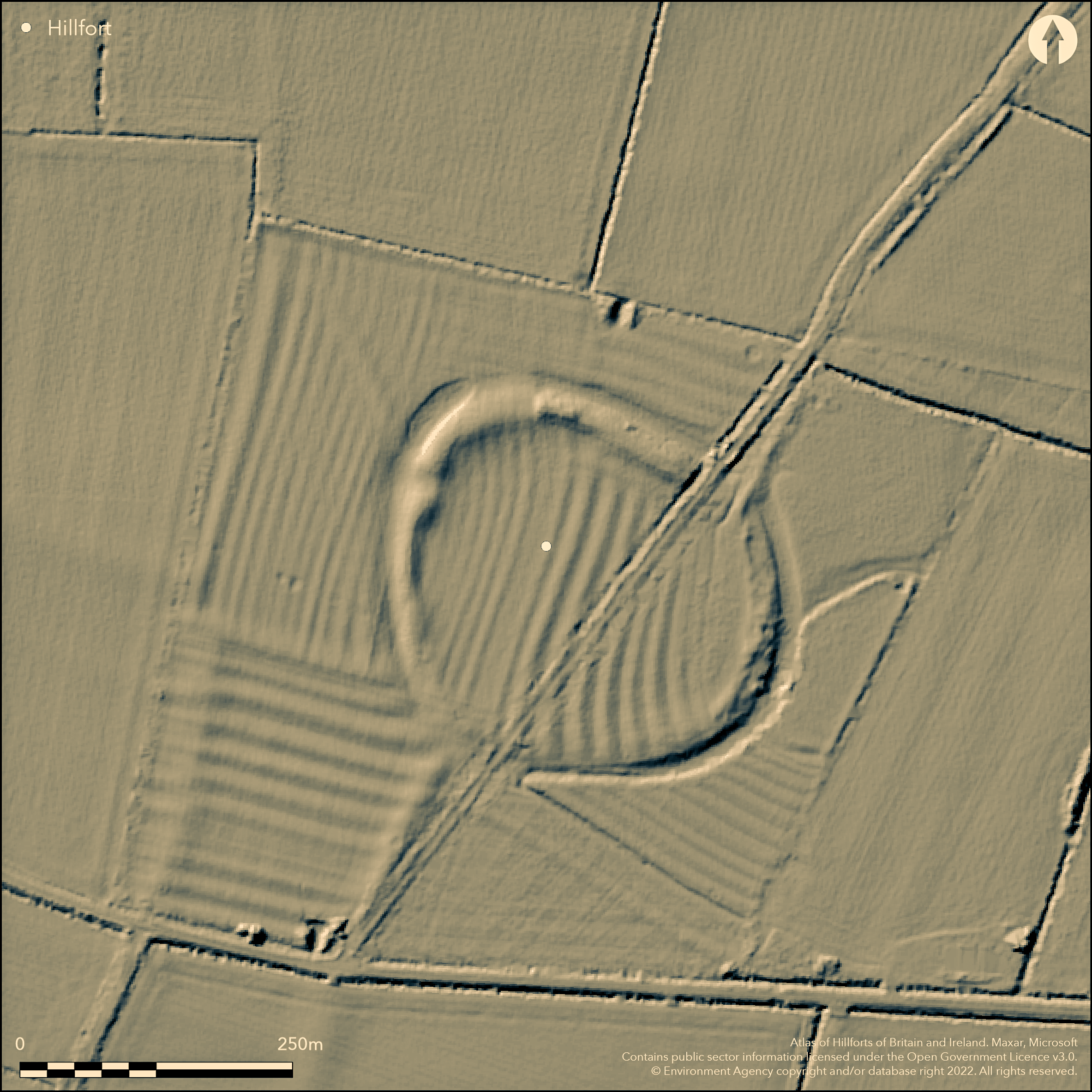
LiDAR 1m DTM Hillshade
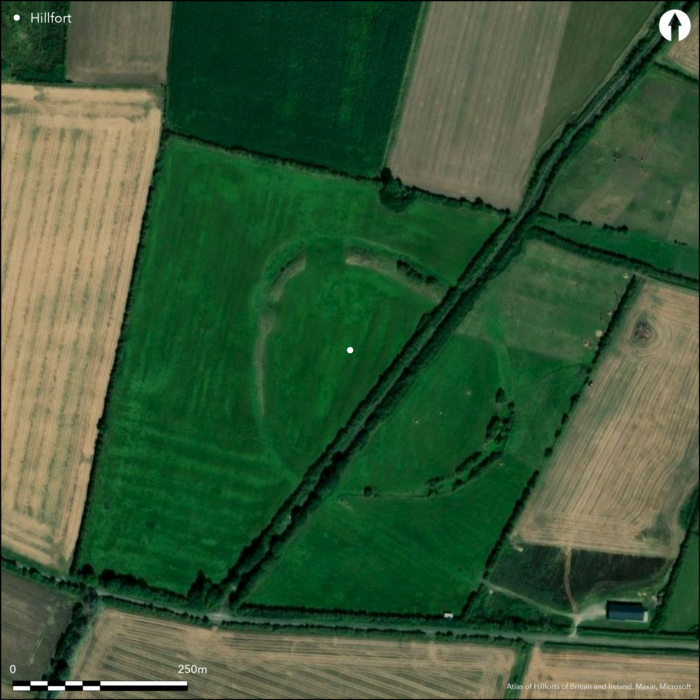
Satellite Imagery
LiDAR 1m DTM Hillshade
Satellite Imagery
Scroll left/right to view further images.
HER: Cambridgeshire 01770a (None)
NMR: TL 4 7 SW 24 (372192)
SM: 1010368
NGR: TL 4221 7029
X: 542282 Y: 270309 (OSGB36)
Situated E of Willingham, low lying on the Fen edge. A much reduced univallate circular plateau hillfort enclosing 2.57ha. The site was probably re-used in Norman times, ridge and furrow is around and across the site, a droveway, the Aldreth Causeway bisects the site, NW-SE, into two fields. There is a well preserved bank and ditch on the W side, more denuded on E side. The NW portion presents a bank approximately 5m in height from ditch bottom to top of bank, which is 9m across the top at the widest point. Ridge and furrow in the interior running N - S appears to have flattened the bank. The ditch holds water. S of the site the ridge and furrow runs E - W. Here the bank is more flattened and spread. The ditch is wet and very broad to E being approximately 6m wide and 1.5m high to top of bank. Along the E side the ditch broadens into a pond. Possible simple gap original entrance on N side where a causeway goes over ditch. Traditionally this site was used by William the Conqueror in his attack on Ely. It has never been excavated nor have any finds been recorded. On 1st Ed OS map (1885-1900).
Citizen Science: ✓
Reliability of Data: Confirmed
Reliability of Interpretation: Confirmed
X: 9549 Y: 6856814 (EPSG: 3857)
Longitude: 0.08577822205215979 Latitude: 52.31242234488028 (EPSG:4326)
Country: England
Current County or Unitary Authority: Cambridgeshire
Historic County: Cambridgeshire
Current Parish/Community/Council/Townland: Willingham
None
| Extant | ✓ |
| Cropmark | ✗ |
| Likely Destroyed | ✗ |
None
| Woodland | ✗ |
| Commercial Forestry Plantation | ✗ |
| Parkland | ✗ |
| Pasture (Grazing) | ✓ |
| Arable | ✗ |
| Scrub/Bracken | ✗ |
| Bare Outcrop | ✗ |
| Heather/Moorland | ✗ |
| Heath | ✗ |
| Built-up | ✗ |
| Coastal Grassland | ✗ |
| Other | ✗ |
Low lying on the Fen edge
| Contour Fort | ✗ |
| Partial Contour Fort | ✗ |
| Promontory Fort | ✗ |
| Hillslope Fort | ✗ |
| Level Terrain Fort | ✓ |
| Marsh Fort | ✓ |
| Multiple Enclosure Fort | ✗ |
| Hilltop | ✗ |
| Coastal Promontory | ✗ |
| Inland Promontory | ✗ |
| Valley Bottom | ✗ |
| Knoll/Hillock/Outcrop | ✗ |
| Ridge | ✗ |
| Cliff/Plateau-edge/Scarp | ✗ |
| Hillslope | ✗ |
| Lowland | ✓ |
| Spur | ✗ |
Dominant Topographic Feature: None
| North | ✗ |
| Northeast | ✗ |
| East | ✗ |
| Southeast | ✗ |
| South | ✗ |
| Southwest | ✗ |
| West | ✗ |
| Northwest | ✗ |
| Level | ✓ |
Altitude: 5.0m
N/A
Undated but probably Iron Age based on the relationship on ridge and furrow.. Re-used in Norman times..
Reliability: D - None
| Pre 1200BC | ✗ |
| 1200BC - 800BC | ✗ |
| 800BC - 400BC | ✗ |
| 400BC - AD50 | ✗ |
| AD50 - AD400 | ✗ |
| AD400 - AD 800 | ✗ |
| Post AD800 | ✗ |
| Unknown | ✓ |
| Pre Hillfort: | None |
| Post Hillfort: | None |
| Morphology/Earthwork/Typology: | None |
On 1st Ed OS map (1885-1900). 1993 RCHME earthwork survey (ref. no. 762602).
| Earthwork Survey (1993): | None |
| 1st Identified Map Depiction (None): | None |
No evidence for interior.
On Fen edge.
| None | ✓ |
| Spring | ✗ |
| Stream | ✗ |
| Pool | ✗ |
| Flush | ✗ |
| Well | ✗ |
| Other | ✗ |
None
| No Known Features | ✓ |
| Round Stone Structures | ✗ |
| Rectangular Stone Structures | ✗ |
| Curvilinear Platforms | ✗ |
| Other Roundhouse Evidence | ✗ |
| Pits | ✗ |
| Quarry Hollows | ✗ |
| Other | ✗ |
None
| No Known Excavation | ✓ |
| Pits | ✗ |
| Postholes | ✗ |
| Roundhouses | ✗ |
| Rectangular Structures | ✗ |
| Roads/Tracks | ✗ |
| Quarry Hollows | ✗ |
| Other | ✗ |
| Nothing Found | ✗ |
None
| No Known Geophysics | ✓ |
| Pits | ✗ |
| Roundhouses | ✗ |
| Rectangular Structures | ✗ |
| Roads/Tracks | ✗ |
| Quarry Hollows | ✗ |
| Other | ✗ |
| Nothing Found | ✗ |
None
| No Known Finds | ✓ |
| Pottery | ✗ |
| Metal | ✗ |
| Metalworking | ✗ |
| Human Bones | ✗ |
| Animal Bones | ✗ |
| Lithics | ✗ |
| Environmental | ✗ |
| Other | ✗ |
NO APPARENT FEATURES
| APs Not Checked | ✓ |
| None | ✗ |
| Roundhouses | ✗ |
| Rectangular Structures | ✗ |
| Pits | ✗ |
| Postholes | ✗ |
| Roads/Tracks | ✗ |
| Other | ✗ |
Possible simple gap original entrance on N side where a causeway goes over ditch. Other gaps associated with medieval green lane.
| 3: | None |
| 2: | None |
Guard Chambers: ✗
Chevaux de Frise: ✗
| 1. Simple Gap (North east): | None |
Univallate with ditch, the ramparts are best preserved on the N and W sides where they reach 2m, ploughing has reduced the S and E ramparts, the ditch is shallow reaching a maximum depth of 1m in the S-E.
| Area 1: | 2.57ha. |
| Total: | 2.57ha. |
Total Footprint Area: Noneha.
None
| ✗ | None |
| ✓ | None |
| NE Quadrant: | 1 |
| SE Quadrant: | 1 |
| SW Quadrant: | 1 |
| NW Quadrant: | 1 |
| Total: | 1 |
| Partial Univallate | ✗ |
| Univallate | ✓ |
| Partial Bivallate | ✗ |
| Bivallate | ✗ |
| Partial Multivallate | ✗ |
| Multivallate | ✗ |
| Unknown | ✗ |
| Partial Univallate | ✗ |
| Univallate | ✗ |
| Partial Bivallate | ✗ |
| Bivallate | ✗ |
| Partial Multivallate | ✗ |
| Multivallate | ✗ |
None
| None | ✗ |
| Earthen Bank | ✓ |
| Stone Wall | ✗ |
| Rubble | ✗ |
| Wall-walk | ✗ |
| Evidence of Timber | ✗ |
| Vitrification | ✗ |
| Other Burning | ✗ |
| Palisade | ✗ |
| Counter Scarp Bank | ✗ |
| Berm | ✗ |
| Unfinished | ✗ |
| Other | ✗ |
None
| None | ✗ |
| Earthen Bank | ✗ |
| Stone Wall | ✗ |
| Murus Duplex | ✗ |
| Timber-framed | ✗ |
| Timber-laced | ✗ |
| Vitrification | ✗ |
| Other Burning | ✗ |
| Palisade | ✗ |
| Counter Scarp Bank | ✗ |
| Berm | ✗ |
| Unfinished | ✗ |
| No Known Excavation | ✓ |
| Other | ✗ |
| ✗ | None |
| ✓ | None |
Number of Ditches: 1
| ✗ | None |
Fox, C. 1948. The archaeology of the Cambridge region : a topographical study of the bronze, early iron, Roman, and Anglo-Saxon ages with an introductory note on the neolithic age. Cambridge: Cambridge University Press, 137.
Kenney J. and Oswold A: 1995, Belsars Hill, Willingham, Cambridgeshire: A Survey by the Royal Commission on the Historical Monuments of England. Proc Cambridge Antiq Soc, 84, 5-14.
Salzman, L.F (ed). 1948. The Victoria County History of Cambridgeshire and the Isle of Ely. Volume 2, 45-6..
Atlas of Hillforts:
Wikidata:
This work is licensed under CC BY-SA 4.0

 and should be cited as:
Lock, Gary and Ralston, Ian. 2024. Atlas of Hillforts of Britain and Ireland. Available at: https://hillforts.arch.ox.ac.uk
Document Version 1.1