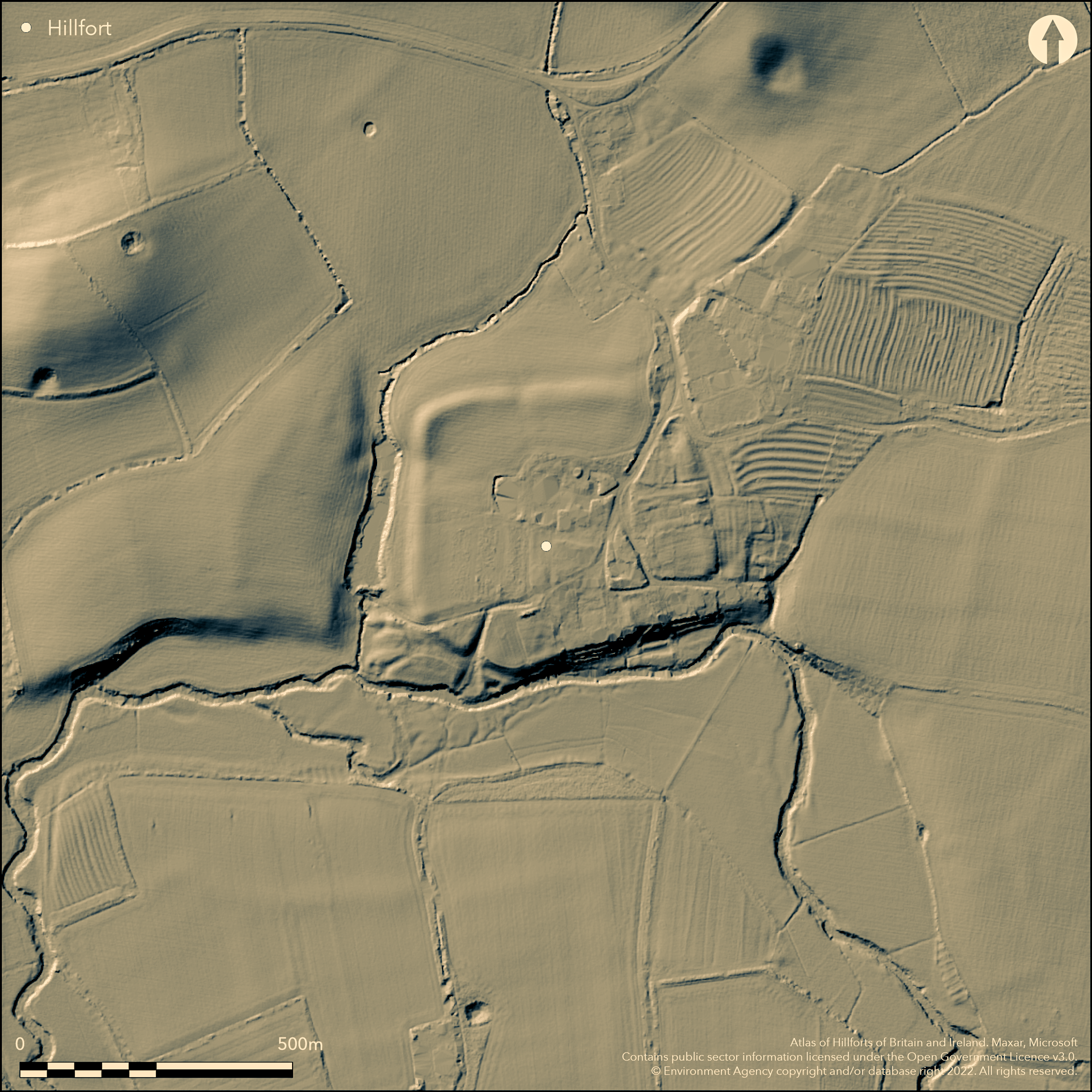
LiDAR 1m DTM Hillshade
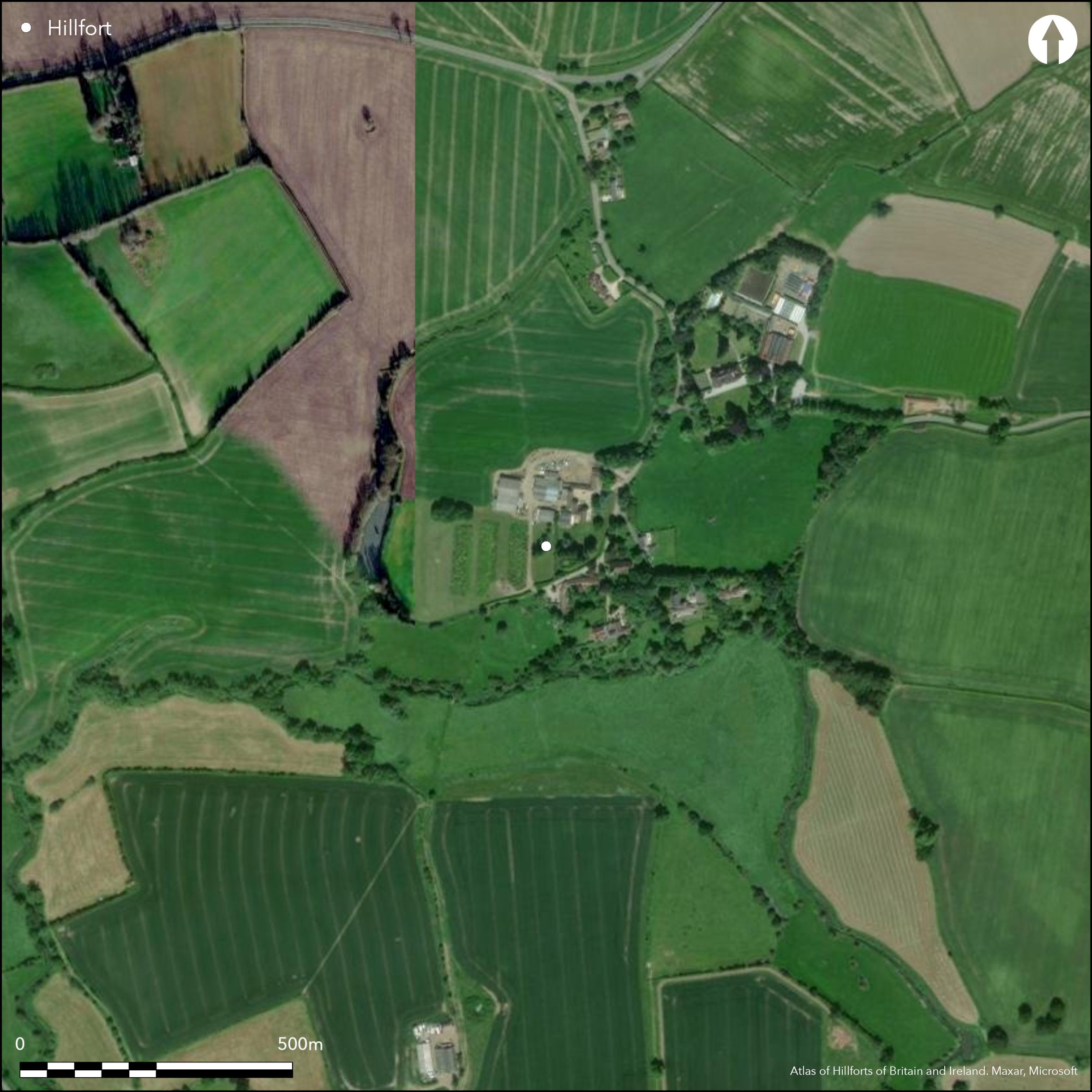
Satellite Imagery
LiDAR 1m DTM Hillshade
Satellite Imagery
Scroll left/right to view further images.
HER: Warwickshire 1840 (None)
NMR: SP 36 NE 3 (335465)
SM: 1009817
NGR: SP 3772 6931
X: 437720 Y: 269310 (OSGB36)
Located on a knoll on the N side of the River Leam, a univallate hillfort enclosing 9ha which encompasses the village of Wappenbury. The site is naturally defined by scarps formed by the River Leam and a tributary to the W. An excavation across the eastern rampart showed it to be 12m wide and constructed of sand and gravel and revetted in clay. The inner edge of the ditch is also lined with clay (Stanley and Stanley 1960). The rampart which is dated to the later Iron Age overlies an earlier Iron Age occupation layer. Deep ploughing and other activity has greatly reduced the rampart. In the N it remains as a break in slope and the infilled ditch can be traced as a slight depression. In the W the site is defined by a scarp bank and a break in the rampart is considered to be the outflow of an adjacent pond, which is possibly contemporary, as seen at Midsummer Hill (Atlas No. 0024). In the S the central part of the rampart has been modified by the construction of Leam Bank Farmhouse and its gardens. River erosion has also caused damage in this area. A 10m wide inturned entrance lies at the south west edge. Causeways across the northern and eastern ramparts are considered to be later. The central part of the interior is occupied by the modern village and associated buildings. Daub found beneath the ramparts suggest structures contemporary with the hillfort construction were present. Iron Age pottery sherds, a perforated stone hammer and a flint leaf arrowhead have been recovered from the interior. Fragments of Roman pottery and kiln debris recovered from the ditch silts and field drains indicate Roman activity in the vicinity of the site during the third and fourth centuries AD. The remains of part of a medieval settlement lie in the E of the enclosure defined by the eastern rampart. The earthwork remains of the settlement include two house platforms which have been built alongside the inner edge of the rampart and a third platform to the NW. A re-examination of the Wappenbury pottery sherds suggests that the few 'Belgic' type sherds give at least an Early Roman terminus post quem for the Wappenbury rampart and it is likely that the hillfort is Middle Iron Age in date, comparable with other similar sites in the Warwickshire region (Booth 1989-90). Recorded on 1885-1900 OS mapping. Scheduled
Citizen Science: ✗
Reliability of Data: Confirmed
Reliability of Interpretation: Confirmed
X: -161194 Y: 6858297 (EPSG: 3857)
Longitude: -1.4480265338200833 Latitude: 52.32056764998366 (EPSG:4326)
Country: England; None
Current County or Unitary Authority: Warwickshire
Historic County: Warwickshire
Current Parish/Community/Council/Townland: Wappenbury; Hunningham
Google Earth historic imagery shows the bank was still visible in the N in 1945
| Extant | ✓ |
| Cropmark | ✗ |
| Likely Destroyed | ✓ |
None
| Woodland | ✓ |
| Commercial Forestry Plantation | ✓ |
| Parkland | ✗ |
| Pasture (Grazing) | ✓ |
| Arable | ✓ |
| Scrub/Bracken | ✗ |
| Bare Outcrop | ✗ |
| Heather/Moorland | ✗ |
| Heath | ✗ |
| Built-up | ✓ |
| Coastal Grassland | ✗ |
| Other | ✗ |
A partial contour fort located on a prominent knoll on the N side of the River Leam at 68m OD
| Contour Fort | ✗ |
| Partial Contour Fort | ✓ |
| Promontory Fort | ✗ |
| Hillslope Fort | ✗ |
| Level Terrain Fort | ✗ |
| Marsh Fort | ✗ |
| Multiple Enclosure Fort | ✗ |
| Hilltop | ✗ |
| Coastal Promontory | ✗ |
| Inland Promontory | ✗ |
| Valley Bottom | ✗ |
| Knoll/Hillock/Outcrop | ✓ |
| Ridge | ✗ |
| Cliff/Plateau-edge/Scarp | ✗ |
| Hillslope | ✗ |
| Lowland | ✗ |
| Spur | ✗ |
Dominant Topographic Feature: Knoll
| North | ✗ |
| Northeast | ✗ |
| East | ✗ |
| Southeast | ✗ |
| South | ✗ |
| Southwest | ✗ |
| West | ✗ |
| Northwest | ✗ |
| Level | ✓ |
Altitude: 68.0m
The parish boundary between Wappenbury and Hunningham is defined by the River in the S
Boundary Type: Parish/Townland
The pottery from Wappenbury suggests the few 'Belgic' type sherds give at least an Early Roman terminus post quem for the Wappenbury rampart and it is likely that the hillfort is Middle Iron Age in date (Booth 1989-90)
Reliability: B - Medium
| Pre 1200BC | ✗ |
| 1200BC - 800BC | ✗ |
| 800BC - 400BC | ✓ |
| 400BC - AD50 | ✓ |
| AD50 - AD400 | ✓ |
| AD400 - AD 800 | ✗ |
| Post AD800 | ✗ |
| Unknown | ✗ |
| Pre Hillfort: | None |
| Post Hillfort: | None |
| Artefactual: | Pottery |
Recorded on 1885-1900 OS mapping. Plan and description in VCH for Warwickshire 1904. Excavated in the 1950's (Stanley and Stanley 1960). Field investigation in 1967. Scheduled
| 1st Identified Written Reference (1904): | None |
| Other (1925): | Scheduled |
| Other (1967): | Field investigation |
| 1st Identified Map Depiction (None): | None |
| Excavation (None): | None |
The site is now occupied by the modern village and associated buildings. The earthwork remains of a medieval settlement lie in the E, and an area of ridge and furrow cultivation also lies within the interior. Daub found within ditch fills suggests buildings contemporary with the hillfort construction. Pottery, spindle whorl, oblong bone dice, bone weaving spear, lead armlet, fragments of Saxo-Norman pottery, including some St. Neots ware perforated stone hammer, possibly of Scottish origin, very similar to one found with a cremation at Stonehenge, leaf arrowhead, incised bronze sheet
Streams in the N, S and W
| None | ✓ |
| Spring | ✗ |
| Stream | ✗ |
| Pool | ✗ |
| Flush | ✗ |
| Well | ✗ |
| Other | ✗ |
None
| No Known Features | ✗ |
| Round Stone Structures | ✗ |
| Rectangular Stone Structures | ✗ |
| Curvilinear Platforms | ✓ |
| Other Roundhouse Evidence | ✗ |
| Pits | ✗ |
| Quarry Hollows | ✗ |
| Other | ✗ |
Ramparts only excavated
| No Known Excavation | ✗ |
| Pits | ✗ |
| Postholes | ✗ |
| Roundhouses | ✗ |
| Rectangular Structures | ✗ |
| Roads/Tracks | ✗ |
| Quarry Hollows | ✗ |
| Other | ✓ |
| Nothing Found | ✗ |
None
| No Known Geophysics | ✓ |
| Pits | ✗ |
| Roundhouses | ✗ |
| Rectangular Structures | ✗ |
| Roads/Tracks | ✗ |
| Quarry Hollows | ✗ |
| Other | ✗ |
| Nothing Found | ✗ |
None
| No Known Finds | ✗ |
| Pottery | ✓ |
| Metal | ✓ |
| Metalworking | ✗ |
| Human Bones | ✗ |
| Animal Bones | ✗ |
| Lithics | ✓ |
| Environmental | ✗ |
| Other | ✓ |
None
| APs Not Checked | ✓ |
| None | ✗ |
| Roundhouses | ✗ |
| Rectangular Structures | ✗ |
| Pits | ✗ |
| Postholes | ✗ |
| Roads/Tracks | ✗ |
| Other | ✗ |
A 10m wide in-turned entrance lies in the SW. Causeways across the defences in the N and E are considered to be later
| 3: | None |
| 2: | None |
Guard Chambers: ✗
Chevaux de Frise: ✗
| 1. In-turned (South west): | None |
Large univallate hillfort enclosing 9ha. Excavation across the eastern defences showed the 12m wide rampart had been constructed of sand and gravel and revetted in clay. The inner edge of the ditch is also lined with clay (Stanley and Stanley 1958).
| Area 1: | 9.0ha. |
| Total: | 9.0ha. |
Total Footprint Area: Noneha.
None
| ✓ | The rampart which is dated to the later Iron Age overlies an earlier Iron Age occupation layer |
| ✓ | None |
| NE Quadrant: | 1 |
| SE Quadrant: | 1 |
| SW Quadrant: | 1 |
| NW Quadrant: | 1 |
| Total: | 1 |
| Partial Univallate | ✗ |
| Univallate | ✓ |
| Partial Bivallate | ✗ |
| Bivallate | ✗ |
| Partial Multivallate | ✗ |
| Multivallate | ✗ |
| Unknown | ✗ |
| Partial Univallate | ✗ |
| Univallate | ✗ |
| Partial Bivallate | ✗ |
| Bivallate | ✗ |
| Partial Multivallate | ✗ |
| Multivallate | ✗ |
None
| None | ✗ |
| Earthen Bank | ✓ |
| Stone Wall | ✗ |
| Rubble | ✗ |
| Wall-walk | ✗ |
| Evidence of Timber | ✗ |
| Vitrification | ✗ |
| Other Burning | ✗ |
| Palisade | ✗ |
| Counter Scarp Bank | ✗ |
| Berm | ✗ |
| Unfinished | ✗ |
| Other | ✗ |
Sand and gravel bank revetted with clay
| None | ✗ |
| Earthen Bank | ✗ |
| Stone Wall | ✗ |
| Murus Duplex | ✗ |
| Timber-framed | ✗ |
| Timber-laced | ✗ |
| Vitrification | ✗ |
| Other Burning | ✗ |
| Palisade | ✗ |
| Counter Scarp Bank | ✗ |
| Berm | ✗ |
| Unfinished | ✗ |
| No Known Excavation | ✗ |
| Other | ✓ |
| ✗ | None |
| ✓ | None |
Number of Ditches: 1
| ✗ | None |
Booth, P. 1989-90. Late Iron Age pottery and the date of Wappenbury Camp. Trans Birmingham & Warwickshire Archaeol Soc. 96, 1-3
Doubleday, H. A. and Page, W. (eds) 1904. Victoria County History, Warwickshire, Vol 1, 400-2
Stanley, M. and Stanley, B. 1960. Defences of the Iron Age Camp at Wappenbury. Trans Birmingham & Warwickshire Archaeol Soc. 76, 1-9
Atlas of Hillforts:
Wikidata:
This work is licensed under CC BY-SA 4.0

 and should be cited as:
Lock, Gary and Ralston, Ian. 2024. Atlas of Hillforts of Britain and Ireland. Available at: https://hillforts.arch.ox.ac.uk
Document Version 1.1