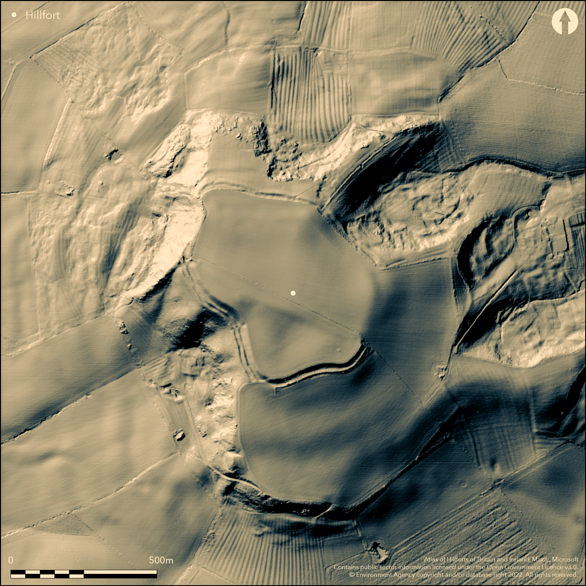
LiDAR 1m DTM Hillshade
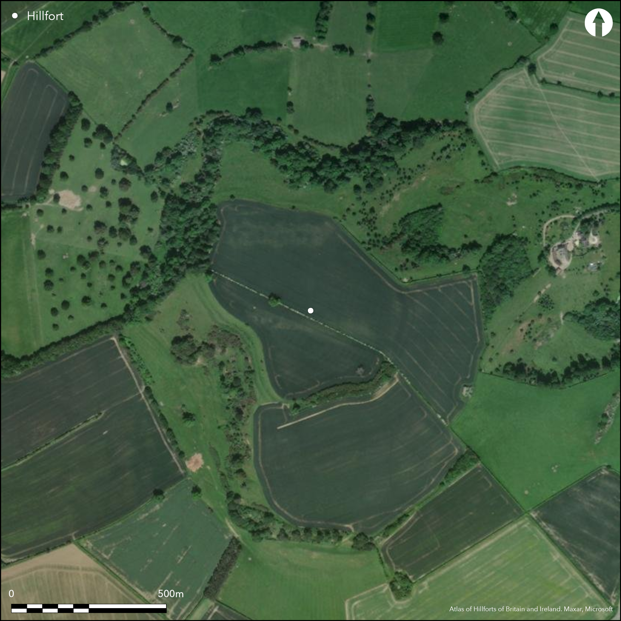
Satellite Imagery
LiDAR 1m DTM Hillshade
Satellite Imagery
Scroll left/right to view further images.
HER: Warwickshire 1825 (None)
NMR: SP 14 NE 6 (330738)
SM: 1011372
NGR: SP 1769 4532
X: 417695 Y: 245325 (OSGB36)
To the S of Upper Quinton, a multivallate contour fort lying at 192m OD on the prominent summit of Meon Hill. The hill is visible in the landscape for several miles. Described as an earthwork with triple ramparts in the 17th century, a map of 1884 shows two ramparts and three ditches along the southern and eastern sides of the site. Today two banks, three ditches and a counterscarp bank survive intermittently around the summit of the hill enclosing 10.4ha. In the S they include an inner rampart, 16m wide ditch, outer bank and further ditch, now infilled. In the SW a double-ditched rampart and counterscarp bank with medial ditches, the inner ditch 16m wide and the outer 9m wide. Only a single bank and 10m wide ditch in the WNW where the slopes are precipitous. In the N the innermost bank and ditch are ploughed out. The banks are now lost in the E but the two infilled ditches survive as buried features. Causeways at the NW and SE edges of the site might mark the site of original entrances. In 1824, 394 spit-shaped currency bars dated to the 3rd century BC were found behind the rampart in the N of the camp, approximately 1.2m beneath the ground surface. Within the interior six round depressions, probably huts, were observed in the S in the early 20th century, one of which was excavated in 1906 (Hodges 1906). It was found to be 4.9m in diameter and 1.1m deep with an encircling stone wall which had collapsed inwards. Iron Age and Romano-British pottery sherds, a broken spearhead and flint flakes were recovered. The site is now continually ploughed and the depressions are no longer visible, although a number of surface finds have been made. An excavation at the site in 1922 (Andrews 1923) recovered pottery, flint and two bronzes. In 1957 an Anglo-Saxon inhumation accompanied by a shield boss, spearhead and ferrule was found within the hillfort (included in Meaney 1964). The site is recorded on 1885 1,2500 OS mapping. Scheduled.
Citizen Science: ✓
Reliability of Data: Confirmed
Reliability of Interpretation: Confirmed
X: -194037 Y: 6819303 (EPSG: 3857)
Longitude: -1.7430650797741971 Latitude: 52.10593880490571 (EPSG:4326)
Country: England
Current County or Unitary Authority: Warwickshire
Historic County: Warwickshire
Current Parish/Community/Council/Townland: Quinton
Included in the 2015 Heritage at Risk Register with principal vulnerability from arable ploughing. On Heritage at Risk Register (2015).
| Extant | ✓ |
| Cropmark | ✓ |
| Likely Destroyed | ✗ |
None
| Woodland | ✓ |
| Commercial Forestry Plantation | ✗ |
| Parkland | ✗ |
| Pasture (Grazing) | ✗ |
| Arable | ✓ |
| Scrub/Bracken | ✗ |
| Bare Outcrop | ✗ |
| Heather/Moorland | ✗ |
| Heath | ✗ |
| Built-up | ✗ |
| Coastal Grassland | ✗ |
| Other | ✗ |
A contour fort lying at 192m OD on the prominent level summit of Meon Hill
| Contour Fort | ✓ |
| Partial Contour Fort | ✗ |
| Promontory Fort | ✗ |
| Hillslope Fort | ✗ |
| Level Terrain Fort | ✗ |
| Marsh Fort | ✗ |
| Multiple Enclosure Fort | ✗ |
| Hilltop | ✓ |
| Coastal Promontory | ✗ |
| Inland Promontory | ✗ |
| Valley Bottom | ✗ |
| Knoll/Hillock/Outcrop | ✗ |
| Ridge | ✗ |
| Cliff/Plateau-edge/Scarp | ✗ |
| Hillslope | ✗ |
| Lowland | ✗ |
| Spur | ✗ |
Dominant Topographic Feature: Summit of Meon Hill
| North | ✗ |
| Northeast | ✗ |
| East | ✗ |
| Southeast | ✗ |
| South | ✗ |
| Southwest | ✗ |
| West | ✗ |
| Northwest | ✗ |
| Level | ✓ |
Altitude: 192.0m
N/A
Finds dating from the Neolithic to the Roman period have been found, some of which are stratified. A Saxon burial has also been found. A hoard of 394 currency bars found in 1824
Reliability: B - Medium
| Pre 1200BC | ✗ |
| 1200BC - 800BC | ✗ |
| 800BC - 400BC | ✓ |
| 400BC - AD50 | ✓ |
| AD50 - AD400 | ✗ |
| AD400 - AD 800 | ✗ |
| Post AD800 | ✗ |
| Unknown | ✗ |
| Pre Hillfort: | None |
| Post Hillfort: | None |
| Artefactual: | None |
| Morphology/Earthwork/Typology: | None |
In Aubrey's Monumenta Britannica (1665-1693). Recorded on 1885 1,2500 OS mapping. Excavated in 1906 (Hodges 1906) and in 1922 (Andrews 1923). Survey in the 1980's recorded the topography of the ramparts and included fieldwalking of the interior and cataloguing and publishing previous finds (Price and Watson 1982). Field investigation in 1968. Scheduled
| 1st Identified Map Depiction (1885): | None |
| Excavation (1906): | None |
| Excavation (1922): | None |
| Other (1927): | Scheduled |
| Other (1968): | Field investigation |
| 1st Identified Written Reference (None): | None |
| Earthwork Survey (None): | None |
Six depressions, one of which was shown by excavation to be a probable roundhouses were visible in undisturbed grassland in the 1920. They are now plough levelled. A number of finds have been recovered from the excavations and fieldwalking and as topsoil finds after ploughing. A hoard of 394 currency bars found in 1824 dated to the 3rd century BC. Neolithic and Bronze Age material including pottery and flints has also been recovered. Iron Age finds include a rotary beehive quern, scatters of Iron Age pottery, animal bone, fired clay/daub, fire-cracked pebbles and possible sling stones. Two Roman coins and a Saxon burial has also been found
Springs and wells on SW slope
| None | ✓ |
| Spring | ✗ |
| Stream | ✗ |
| Pool | ✗ |
| Flush | ✗ |
| Well | ✗ |
| Other | ✗ |
Saucer-shaped depressions, now ploughed out
| No Known Features | ✗ |
| Round Stone Structures | ✗ |
| Rectangular Stone Structures | ✗ |
| Curvilinear Platforms | ✗ |
| Other Roundhouse Evidence | ✓ |
| Pits | ✗ |
| Quarry Hollows | ✗ |
| Other | ✗ |
None
| No Known Excavation | ✗ |
| Pits | ✗ |
| Postholes | ✗ |
| Roundhouses | ✓ |
| Rectangular Structures | ✗ |
| Roads/Tracks | ✗ |
| Quarry Hollows | ✗ |
| Other | ✗ |
| Nothing Found | ✗ |
None
| No Known Geophysics | ✓ |
| Pits | ✗ |
| Roundhouses | ✗ |
| Rectangular Structures | ✗ |
| Roads/Tracks | ✗ |
| Quarry Hollows | ✗ |
| Other | ✗ |
| Nothing Found | ✗ |
None
| No Known Finds | ✗ |
| Pottery | ✓ |
| Metal | ✓ |
| Metalworking | ✗ |
| Human Bones | ✓ |
| Animal Bones | ✓ |
| Lithics | ✓ |
| Environmental | ✗ |
| Other | ✗ |
Partial woodland
| APs Not Checked | ✓ |
| None | ✗ |
| Roundhouses | ✗ |
| Rectangular Structures | ✗ |
| Pits | ✗ |
| Postholes | ✗ |
| Roads/Tracks | ✗ |
| Other | ✗ |
Causeways at the NW and SE edges of the site might mark the site of original entrances.
| 2: | None |
| 2: | None |
Guard Chambers: ✗
Chevaux de Frise: ✗
| 1. Other Forms (North west): | None |
| 2. Other Forms (South east): | None |
Multivallate contour fort described as an earthwork with triple ramparts in the 17th century, a map of 1884 shows two ramparts and three ditches along the southern and eastern sides of the site. Today two banks, three ditches and a counterscarp bank survive intermittently around the summit of the hill enclosing 10.4ha. In the S they include an inner rampart, 16m wide ditch, outer bank and further ditch, now infilled. In the SW a double-ditched rampart and counterscarp bank with medial ditches, the inner ditch 16m wide and the outer 9m wide. Only a single bank and 10m wide ditch in the WNW where the slopes are precipitous. In the N the innermost bank and ditch are ploughed out. The banks are now lost in the E but the two infilled ditches survive as buried features.
| Area 1: | 10.4ha. |
| Total: | 10.4ha. |
Total Footprint Area: Noneha.
None
| ✗ | None |
| ✓ | Two banks, three ditches and a counterscarp bank survive intermittently around the summit of the hill. Three ditches in the S and E |
| NE Quadrant: | 1 |
| SE Quadrant: | 3 |
| SW Quadrant: | 2 |
| NW Quadrant: | 1 |
| Total: | 3 |
| Partial Univallate | ✓ |
| Univallate | ✗ |
| Partial Bivallate | ✓ |
| Bivallate | ✗ |
| Partial Multivallate | ✓ |
| Multivallate | ✗ |
| Unknown | ✗ |
| Partial Univallate | ✗ |
| Univallate | ✗ |
| Partial Bivallate | ✗ |
| Bivallate | ✗ |
| Partial Multivallate | ✗ |
| Multivallate | ✗ |
None
| None | ✗ |
| Earthen Bank | ✓ |
| Stone Wall | ✗ |
| Rubble | ✗ |
| Wall-walk | ✗ |
| Evidence of Timber | ✗ |
| Vitrification | ✗ |
| Other Burning | ✗ |
| Palisade | ✗ |
| Counter Scarp Bank | ✓ |
| Berm | ✗ |
| Unfinished | ✗ |
| Other | ✗ |
No excavation of the ramparts
| None | ✗ |
| Earthen Bank | ✗ |
| Stone Wall | ✗ |
| Murus Duplex | ✗ |
| Timber-framed | ✗ |
| Timber-laced | ✗ |
| Vitrification | ✗ |
| Other Burning | ✗ |
| Palisade | ✗ |
| Counter Scarp Bank | ✗ |
| Berm | ✗ |
| Unfinished | ✗ |
| No Known Excavation | ✓ |
| Other | ✗ |
| ✗ | None |
| ✓ | None |
Number of Ditches: 3
| ✗ | None |
Andrews, F. B. 1923. Meon Hill. Birmingham Archaeol Soc. 49, 57
Hodges, T R, 1906 Meon Hill and its treasures, Trans Birm Archaeol Soc 32, 111-125.
Meaney, A. 1964. Gazetteer of Early Anglo Saxon Burial Sites. Allen & Unwin, 217
Price, E A, and Watson, B, 1982 Meon Hill, Warwickshire: interim report on field survey of the Iron Age hillfort, West Mids Archaeol 25, 77-82.
Thomas, N. 1974. An archaeological gazetteer for Warwickshire: Neolithic to Iron Age. Trans Birm Warwicks Archaeol Soc, 86, 16-48.
Atlas of Hillforts:
Wikidata:
This work is licensed under CC BY-SA 4.0

 and should be cited as:
Lock, Gary and Ralston, Ian. 2024. Atlas of Hillforts of Britain and Ireland. Available at: https://hillforts.arch.ox.ac.uk
Document Version 1.1